Sed Strat Week 10
1/26
Earn XP
Description and Tags
estuaries
Name | Mastery | Learn | Test | Matching | Spaced | Call with Kai |
|---|
No analytics yet
Send a link to your students to track their progress
27 Terms
Estuary influences
Fluvial, wave, and tidal influence
Estuary
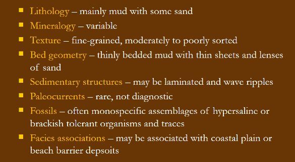
Brackish, semi-enclosed body of water with connection to the open sea where fresh water is mixed with saline water. Most are transgressive (drowned river mouth) and temporary, as when water recedes again the area becomes a delta. Margins are often sand/mud flats
Link between estuaries and incised valleys
Regression (low BL) exposes river valleys, allowing for gradients to steepen and rivers to break their channels, carving out valley walls to make them wider. Ocean water then fills this space when BL rises, creating the estuary
Base level
lowest elevation to which a river can erode. Lowers with regression and raises with transgression
Lagoon
Has no strong river-valley association, filled entirely with marine water and sediment. Not the same as an estuary
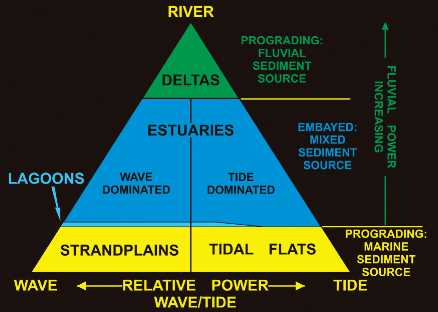
Coastal classification chart
image
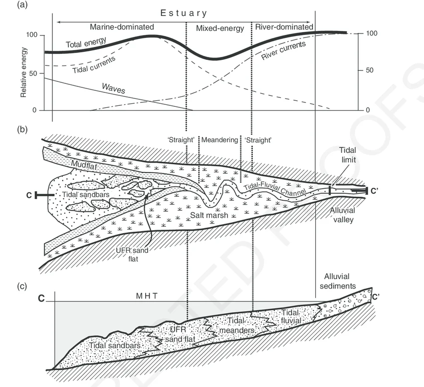
Estuary energy
Fluvial energy decreases moving closer to the coast due to proximity to the ocean, decrease in gradient, and widening of river channel
Marine energy decreases moving up-river due to increased fluvial input, steepening of gradient, and narrowing of river channel
Outer estuary
High energy zone dominated by marine processes
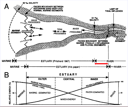
Central estuary
relatively low-energy central zone, where marine and river currents are approximately equal in strength. Calm, tends to be finest grained

Inner estuary
High energy, inland zone dominated by fluvial processes

Wave dominated estuary
One maxima occurs at the estuary mouth due to wave energy, and another at the head, due to river current. A central energy minimum occurs between, becoming less pronounced as the estuary fills
Marine, horizontal sand bodies occur at the mouth, which are cut by tidal inlets flowing into the central estuary (calm, muddy area). Limit of the shoreface is the marine limit of the estuary
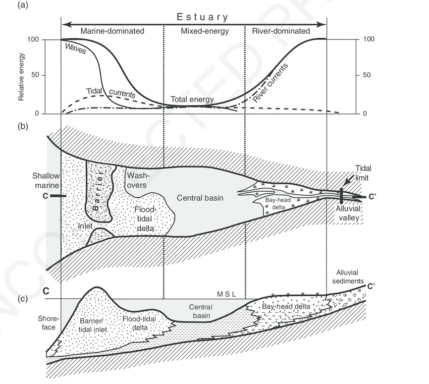
Bayhead delta
Sand and gravel are deposited at the head (top) of the estuary; typical deltaic form. Often river-dominated

Tide dominated estuary
Mostly macrotidal; sediment is finest close to shore. Flood tide inundates coastal mud flats. Sand bodies occur in elongate, submarine channels at the mouth rather than long, horizontal bars. Bayhead delta is not present at estuary head
May be marked by mud drapes, herringbone cross-strat (rare), and reactivation surfaces. Areas of strongest current are marked by upper plane bed flow
Heterolithic (IHS)
Consist of more than one grain size, like sand and mud (tidal estuary channel sands and PB deposits)
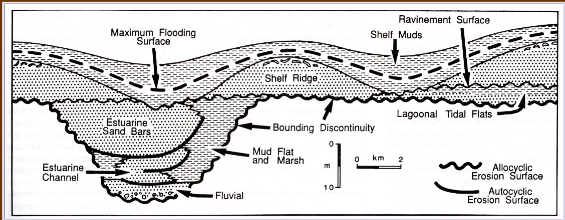
Sequence stratigraphy
At the low stand (regressive), there is an erosional unconformity, in which the water was at its lowest and after this point began to rise (fluvial deposits, sand)
At the high stand (transgressive), there is a maximum flooding surface, in which the water was at its deepest and after this point began to lower (muddy deposits, shale, silt)
Submarine canyon
Steep-walled canyon cutting across the continental shelf that funnels coarse sediment into deeper water (turbidity currents). Often formed by river incision during LSTs
often several km deep and 10s of km wide
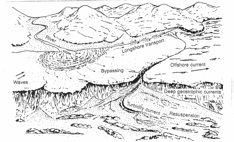
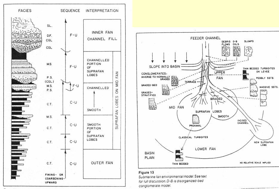
Submarine fan
Sediment that submarine canyons transport into deeper water extends out onto the continental rise, forming underwater fans that extend in a similar manner to an alluvial fan
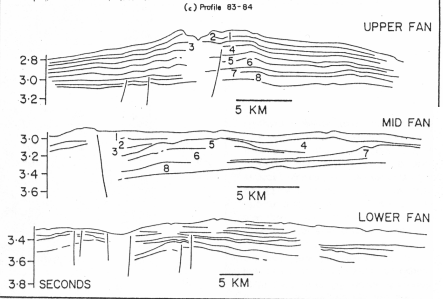
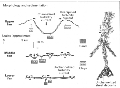
Submarine fan stacking pattern
Suprafan lobes prograde similarly to a delta. An upward coarsening sequence is present, but lobe switching is difficult to define (unlike a delta)
upward fining packages occur in fan channels due to lateral accretion
Passive margin types
Normal clastic, carbonate (steep), delta w/ tectonic features (growth faults), salt tectonics (diapirs)
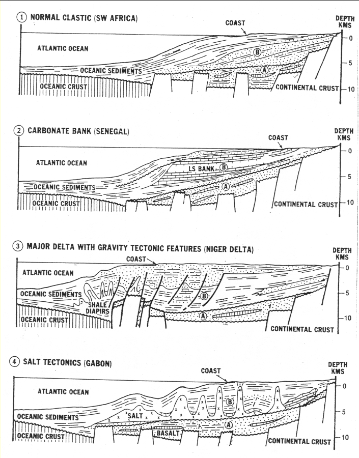
Breakup unconformity
major erosional surface separating older faulted rift sediments (syn-rift) from younger, undisturbed post-rift sediments. Marks transition from rifting to spreading
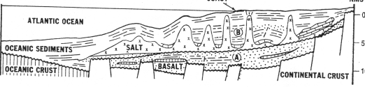
Salt tectonics
Salt tends to flow upwards due to density imbalance; it is lighter than surrounding material. As a result, it pierces upper layers of sediment and may become exposed as a diapir at the surface, with strata subsiding between diapirs and creating mini basins
Bouma sequence
Upward fining sequence describing the flow of a turbidite; distal sediments are finer while proximal sediments are coarser. Often not fully preserved

Flow stripping
The top of the turbidity current is separated from the heavier underlying sediment as it runs over an underwater feeder channel, which captures that coarser sediment. The finer overlying sediment runs into the outer fan
4 flow types (and their mechanisms)
debris flows (internal strength of matrix), liquefied flows (upward escape of fluid), grain flows (grain-to-grain impacts), turbidity currents (turbulence of flow)
Pelagic (biogenic)
Biogenic sediment not derived from weathering
Hemi-pelgaic (non-biogenic)
Fine, clay sized sediment from continental weathering that can stay in suspension for long periods of time
Neap vs spring tide
Neap is tidal minimum; moon is directly above/below the earth and the sun is on the left
Spring is tidal maximum; moon is to the left or right of the earth and sun is on opposing side
