EQ2 - How do characteristic coastal landforms contribute to coastal landscapes?
1/28
Earn XP
Description and Tags
still need to do sediment cell including negative + positive feedback + case study
Name | Mastery | Learn | Test | Matching | Spaced |
|---|
No study sessions yet.
29 Terms
What is a wave?
A medium through which energy is transferred.
They’re created by the wind blowing across the surface of the sea.
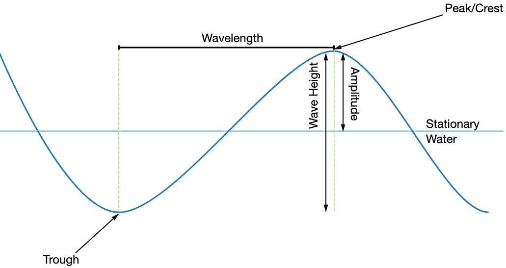
What does wave size depend on? (how can a wave be large)
the stronger the wind
the longer it blows for
the longer the fetch(distance the wind blows over)
the more shallow the water is
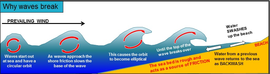
How does a wave break?
in open water, little horizontal movement of water; moves up and down(vertical).
as waves approach coastline, it encounters increasing contact with shelving sea bed, which exerts frictional force on base of wave.
this changes normal circular orbit of wave into elliptical.
as wave gets closer to coast, impact of friction grows, with top of wave moving faster than the base of the wave.
eventually, a critical point is reached where top of the wave(crest) cuves over and creates a breaking wave
water flows up the beach as swash, and loses energy so gravity pulls water back down as backwash.
Swash aligned coast
Produced when waves break parallel to the coast.
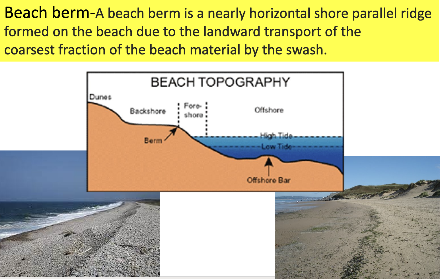
Beach berms, cusps, ridges + runnels.
Beach sediment profile: beach berm
Destructive waves carry large coarse material.
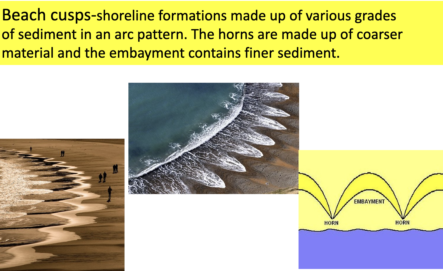
Beach sediment profile: beach cusp
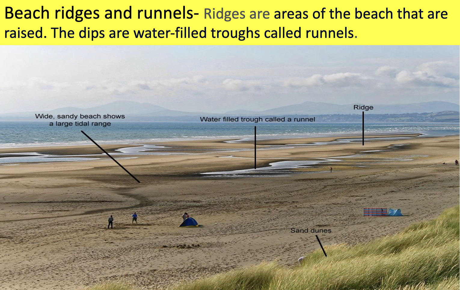
Beach sediment profile: beach ridges + runnels
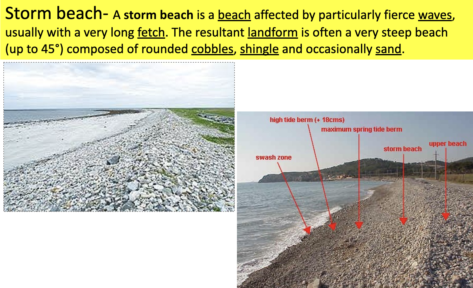
Beach sediment profile: storm beach
How does the type of wave influence beach morphology + beach sediment profiles
Constructive waves: Build wide, gentle sloped beaches by moving sediment up beach + deposition (strong swash + weak backwash). Typically sandy beaches as larger sediment is heavier + more difficult to carry- constructive waves do not have the energy + strength to transport them.
Destructive waves: Build smaller, steeper beaches due to weak swash + strong backwash, so more sediment is transported back into sea by waves. Pebbles aren’t moved far up the beach (weak swash), resulting in steeper profiles. Pebble beaches: Have strength + energy to transport heavier + larger sediment.
Short term(daily) influences of waves on beach morphology + beach sediment profiles
storms
produces strong destructive waves pushing large sediment up the beach and picking up smaller sediment, creating steep beach profile.
tides
can create a tidal berm at the back of a beach or storm shingle ridge deposited by storm waves at high tide.
Long term/ seasonal influences of waves on beach morphology + beach sediment profiles
seasons
Destructive, high-energy waves dominate winter, lowering angle of beach profile and spreading shingle over the whole beach. Offshore ridges/bars formed by destructive wave erosion and subsequent deposition of sand and shingle offshore.
In summer, constructive, low-energy waves dominate, steepening beach angle and sorting particles by size, with larger shingle particles towards back of beach. In summer, constructive waves build berm ridges, typically of gravel/shingle at high tide mark
long-shore drift
causes some beaches to be more built up by net deposition and others to be vulnerable to erosion.
climate change
could cause more extreme weather events + create winter beach profiles more often.
Erosional processes
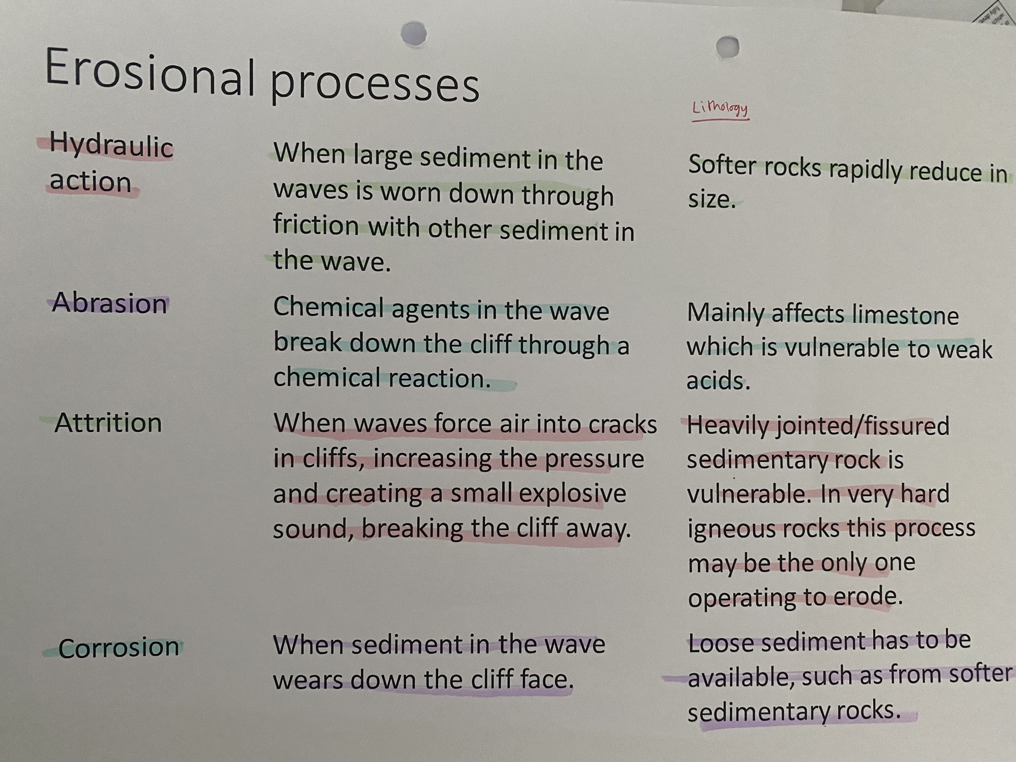
Landforms created by erosion
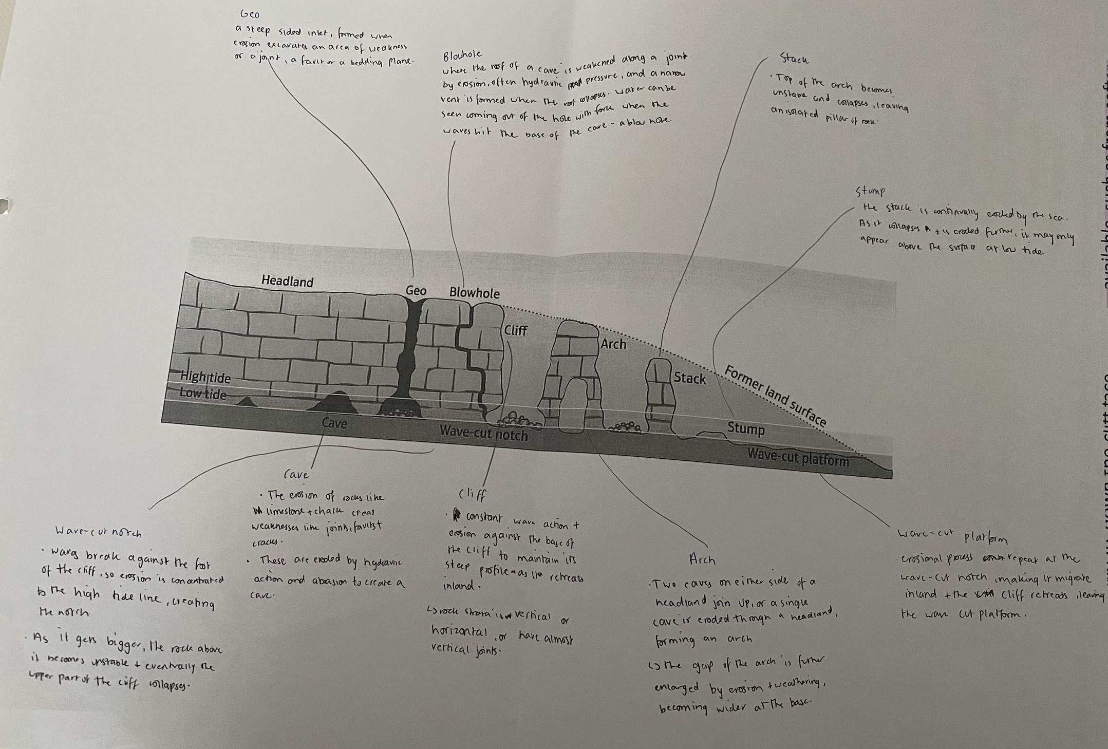
Wave cut notches + platforms
-seven sisters cliff has a wave cut notch
-white cliffs of dover have wave cut platform
Cave, arch, stack, stump
-old Harry’s Rocks-stacks
-old Harry’s Wife- stump
Transportation processes
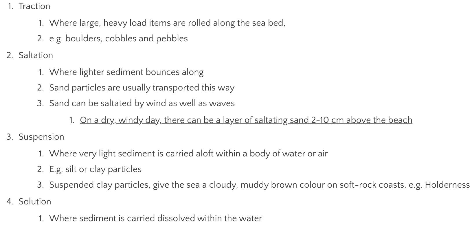
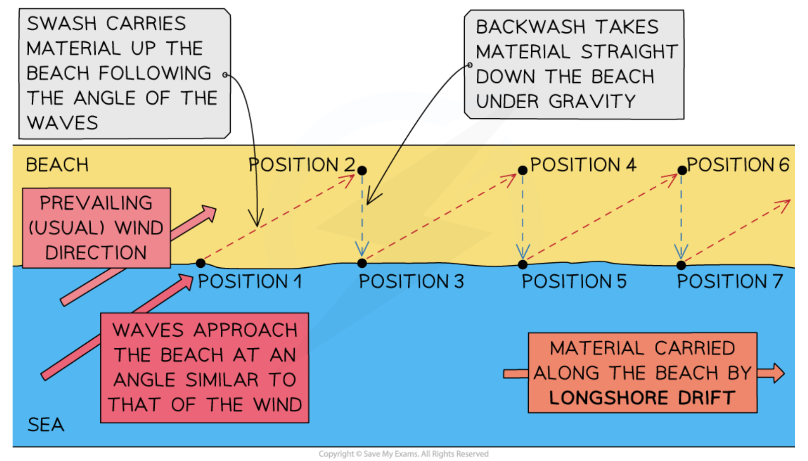
Longshore drift
The net movement of sediment along the coastline when waves approach the coast at an angle, driven by swash and backwash.
How do tides + currents affect LSD + transport of sediment?
Currents: The flow of water in a particular direction driven by winds.
transport sediment in nearshore + offshore zones
rip (underwater) currents on beach transport sediment a few metres out to sea
Tides: Changes in sea level produced by the gravitational pull of the moon + sun.
large tidal ranges (difference between high+low tide) produce larger tidal currents in near+offshore zones which transport more sediment
Drift aligned coast
Produced where waves break at an angle to the coast.
Spits
Bars + tombolos
Deposition
Waves lose energy, dropping all the sediment and particles it was transporting.
-may take place in sheltered areas where there is reduced energy, e.g. a cove
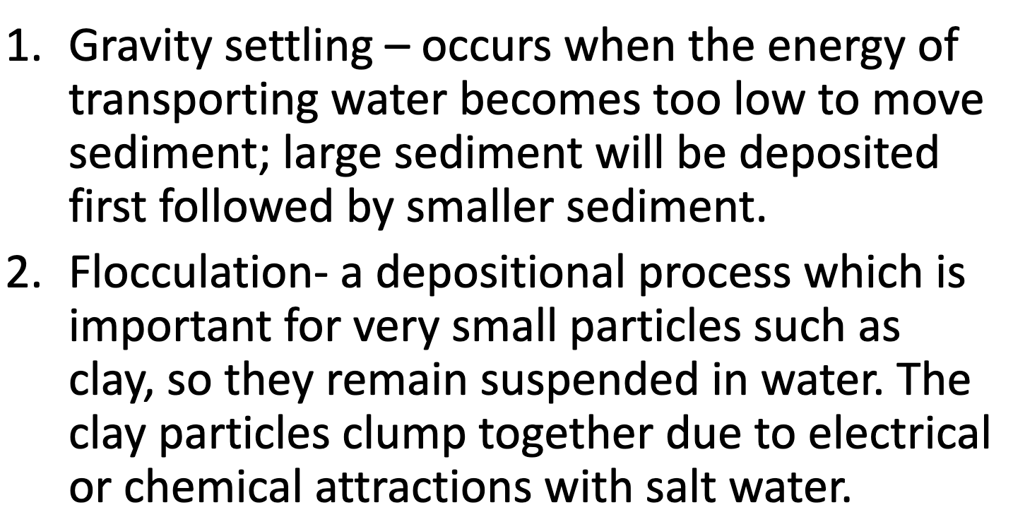
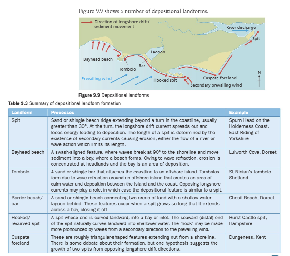
Deopositional landforms
Weathering
Weathering is the breakdown of rock in situ(without movement).
Physical/ mechanical weathering
Freeze thaw weathering
rainwater/snow collect in the rock.
during the day, ice melts + water seeps deeper into the cracks
at night, temp drops and water freezes and expands in volume
the increase in volume of ice puts pressure on cracks in the rock, causing them to split further open
Chemical weathering
Solution: acidic rain/seawater removes rock in solution
Oxidation: minerals are weakened when exposed to air
Hydrolysis: acid rain reacts with minerals to produce soluble material (easily washed away)
Biological weathering
Breakdown of rock due to vegetation/ animals
plant roots grow into small cracks in the rock
as the roots grow, the crack becomes larger
this causes small pieces of rock to break away
How does weathering affect rate of recession
Weathering increases rate of recession
It weakens rocks, making them more vulnerable to mass movement and cliff retreat
Rocks weathered in the foreshore zone (between the high and low tide mark) are more rapidly eroded by marine erosion or hydraulic action
For example, in some more vulnerable strata wave-cut notch forms and deepens more rapidly in weathered rock, leading to faster recession through undercutting and mass movement collapse
What is mass movement + the 3 types of mass movement
Downhill movement of material under influence of gravity.
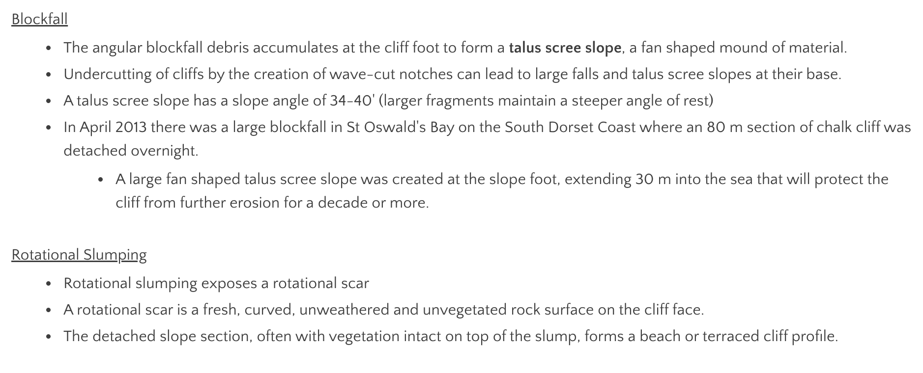
blockfall, rotational slumping, landslides.
Blockfall/ rockfall
Where a rock fragment breaks away and either drops vertically (so it isn't in contact with the cliff) or bounces downslope
occurs on steep slopes ( >40°)
caused by: hot weather dries + shrinks soil which allows rocks to fall, extreme weathering loosens rocks which become unstable + collapses, rainfall softens surface leading to collapse of slope
Rotational slumping
In dry weather, soil above sand cracks, funnelling water into permeable sand
Water accumulates in the lower sand as it is unable to to percolate into the impermeable clay.
The weight of the water adds to the downslope gravitational force, while wave erosion created a notch at the cliff foot, removing support
eventually slumping occurs
occurs in:
weak rocks e.g. clays and shales
unconsolidated material e.g. boulder clay, sands, gravel
rocks with complex geology
Landslides
the downslope movement of discrete blocks of rock down a flat/linear slip plane, maintaining contact with the cliff surface throughout.
-discrete blocks are released by mechanical weathering of well jointed rocks(limestone). gravity then pulls them down
occur in consolidated rocks with with joints or bedding planes sloping seawards
Landforms created by mass movement
talus scree slopes: a fan shaped mound of material formed from the angular blockfall debris accumulating at the cliff foot. e.g. Lizard Point, Cornwall
rotational scars: exposed by rotational slumping- a fresh, curved, unweathered + unvegetated rock surface on the cliff face. e.g. Lyme Regis, Jurassic coast
terraced cliff profiles: the detached slope section, often with vegetation intact on top of the slump. e.g. White cliffs of Dover