FAA ATC system and NAS
1/37
Earn XP
Description and Tags
Name | Mastery | Learn | Test | Matching | Spaced | Call with Kai |
|---|
No analytics yet
Send a link to your students to track their progress
38 Terms
FAA MISSION
Provide the safest, most efficient aerospace system in the world.
Regions
9 Regions
9 regional offices and the Mike Monroney Aeronautical Center in OK
ATO (Air Traffic Organization)
Is responsible for ensuring the safety, efficiency, and security of air traffic operations across the entire National Aerospace System (NAS)
Under the Chief Operating Officer (COO)
Air Traffic Service Areas
3 Service Areas
Western
Central
Eastern
RESPONSIBLE FOR:
En Route Services
Terminal Services
Capabilities
Performance Metrics
Finances
Administrative Communication
organization Communication
overall services
Operations Measure
ATC System
Primary purpose:
prevent a collision between aircraft operating in the system
Provide a safe, orderly, and expeditious flow of traffic
Provide support for National Security and Homeland Defense
Positive Control
The separation of all air traffic within designated airspace by ATC
ATC provides positive control among aircraft under its control.
STANDARDS: are established by the FEDERAL GOVERNMENT
DESIGNATED IN:
miles
Altitude (feet)
Minutes
Duty Priority
Separate aircraft and issue safety alerts
Other Duties
Support National Security
Provide and Solicit Weather
Provide additional services
Procedural Preference
Automated Procedures:
Over non-automation procedures When workload, communications, and equipment capabilities permit
Radar Separation:
Over non-radar when it will be an operational advantage and workload, communications, and equipment permit.
Nonradar Separation:
Over radar when an operational advantage will be gained.
Operational Priority
1- Good judgment must be used in each situation to facilitate the most expeditious movement priority aircraft
2- ATC service is provided to aircraft on a “first come, first served” basis as circumstances permit, EXCEPT
aircraft in Distress
Civilian air ambulance flights (MEDEVAC)
Presidential aircraft
SAR (search & rescue)
Special military and civilians operations
Flight check aircraft
Instrument Flight Rules (IFR) aircraft over Special Visual Rules (SVR) aircraft
Diverted flights
Additional services
Are advisory info provided by ATC
NOT optional
Air Traffic Control Facility Types
Flight Service Station FSS
Terminal ATC facilities
Airport Traffic Control Towers ATCT
Terminal Radar Approach Controls TRACON
Air Route Traffic Control Center ARTCC (En Route facilities)
Complexity
Organizational structure of ea ATC facility varies depending on complexity
determined by many factors
# of aircraft operations a facility handles
Runway configuration
Facility Classification
Factors that determine a facility’s level
traffic volume
Fleet mix
Proximity to airports
Class of airspace
Terrain
# of runways
Runway configuration
Air Traffic Facility Organization (ATO) Chart
Controller-In-Charge (CIC) assumes operational responsibilities for the Operational Supervisor (OS) when a supervisor is unavailable
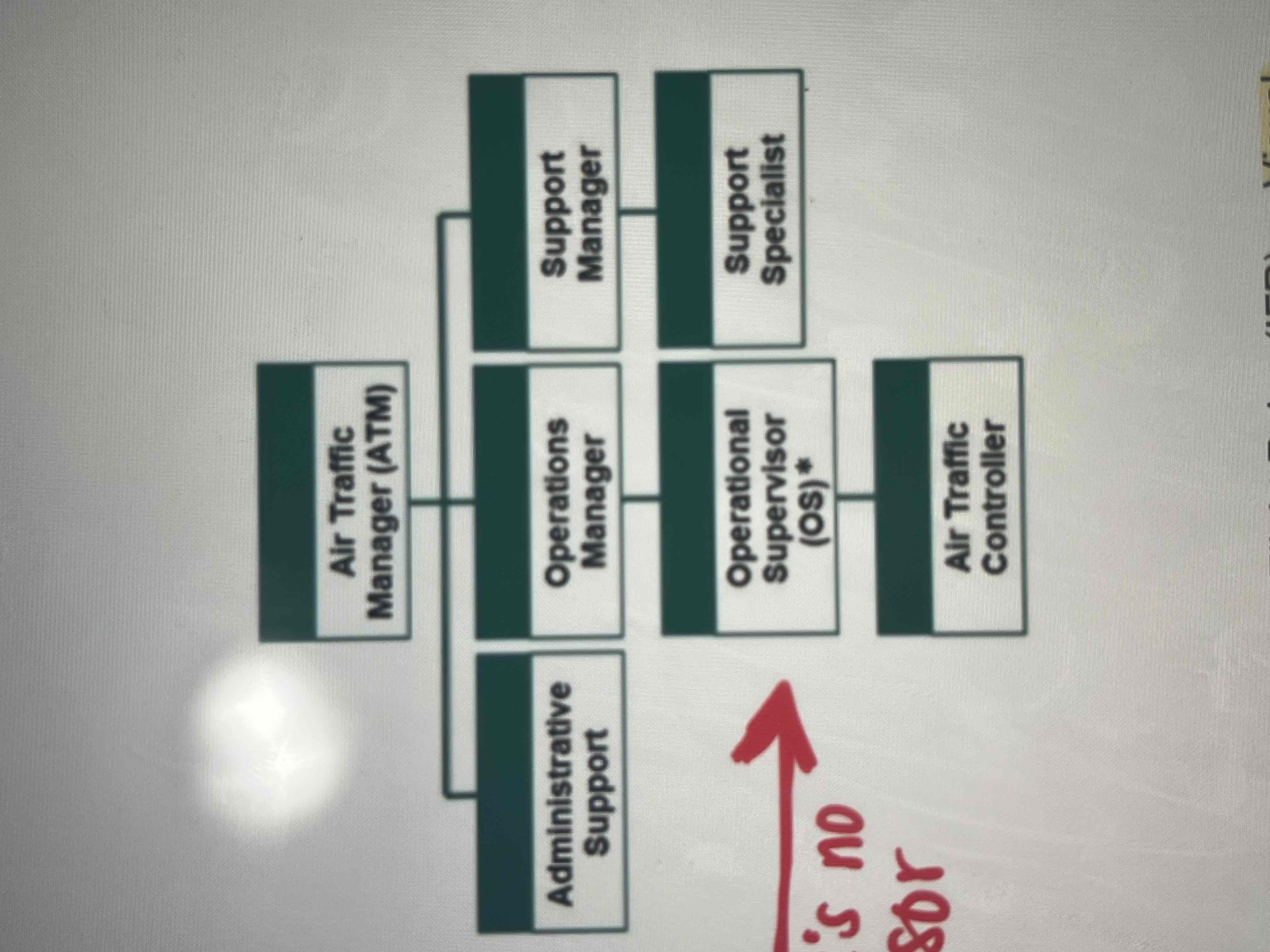
CENTERS are divided into AREAS then subdivided into SECTORS
Four basic positions in an FSS ( Flight Service Station)
1) Flight Data/ NOTAM Coordinator :
compile, evaluate, record, and disseminate NOTAMs and flight movement data
Initiate required SAR situations
2) Broadcast :
compile, evaluate, record and disseminate weather and flight info through the Automatic Flight Information Service (AFIS - Alaska only)
3) Preflight:
brief and translate to pilots:
current and forecast weather
NOTAMs
Flow control restrictions that the pilot might encounter along the route of flight
Apply VFR Not Recommended procedures as prescribed
4) Inflight:
provides services to airborne pilots
Terminal Facilities Types
ATCTS (Towers) - provide ATC service to aircraft operating on or in the vicinity of the airport
TRACONs - provide radar service to arriving, departing , and some en route aircraft
Airport Control Tower (ATCT) services
(terminal facility)
Controllers:
use air/ground communications, visual signaling, and other devices to provide ATC services to aircraft operating in the vicinity of or an airport
Authorize aircraft to land or take off at the airport controlled by the tower or to transit tower-controlled airspace
May also provide approach control services (radar or nonradar)
ATCT 6 positions:
1- flight data:
assists the other air traffic controllers and performs clerical duties
Compiles statistical data
2- Clearance Delivery (CD):
Normally the FIRST controller a pilot talks to when departing and airport
3- Ground Control (GC):
responsible for ensuring that aircraft are separated from other aircraft, ground vehicles and obstructions while taxiing
4- Local control (LC)
Responsible for separating and providing safety alerts to aircraft in the airspace surrounding the airport and aircraft on the active runways
5- Tower Coordinator:
Works to ensure that the overall operation is at its greatest capacity while maintaining safety standards
Managing traffic flow
6- Tower Associate
“assistant” to either or both of the “Tower positions” including monitoring the situation for anything Local or Ground may NOT be aware of
Terminal Radar Approach Controls (TRACONs) Facility
An ATC facility that uses radar and nonradar capabilities to provide control services to aircraft arriving, departing, and transiting airspace in a terminal areas
may serve one or more airfields, and control is exercised primarily by direct pilot and controller communications
TRACONs are divided into SECTORS of airspace
Combined ATCT / TRACON - in smaller metro areas, the TRACON may be located within or near the same structure as the Tower for the primary airport it serves =
“Up/Down Facility”
No TRACON- the ARTCC (Air Route Traffic Control Center provides approach control services
Terminal Radar Team
the team as a whole has responsibility for the safe and efficient operation of that facility/sector
Four Basic Positions
1- Flight Data:
similar to tower
processing and forwarding flight plan info
Compiling statistical data
2- Radar Associate
ensure separation
3- Radar Controller
Uses the radar display and air-to-ground frequencies to separate and sequence aircraft in the sector’s airspace
4- Radar Coordinator
perform INTERfacility/ sector/ position coordination of traffic actions
Advise the radar position and the Radar Associate position of facility/sector actions required to accomplish the safe and efficient operation of the sector
Perform and of the functions of the radar team that will assist in meeting situation objectives
Radar Position: has the responsibility of managing the overall sector operations, including radar separation and traffic flows
Air Route Traffic Control Centers (ATCC)
Facility commonly referred to as a center. Provides en route ATC service to IFR/ VFR aircraft principally during en route phase of flight
En Route phase flight: the segment of flight between departure and destination terminal areas
center divide into area divide into sectors
En Route Sector Team
4 Basic positions in the ARTCC
1- Radar Flight Data :
responsible for compiling statistical data and forwarding flight plan
2- Radar Associate
often called “D side”
Ensure seperaration
Initiate control instructions
Managing flight strip info
Assisting the radar position w coordination
3- Radar
often called “R side”
Communicates directly w the aircraft and uses radar info as the primary means of separation
4- Radar Coordinator
- referred to as “Tracker” of “Handoff controller”
Perform INTERfacility/ INTRAfacility/ sector/ position coordination of traffic actions
Traffic Management (TM) System
Mission: to balance air traffic DEMAND with system CAPACITY to ensure the Mac efficient utilization of the National Airspace (NAS)
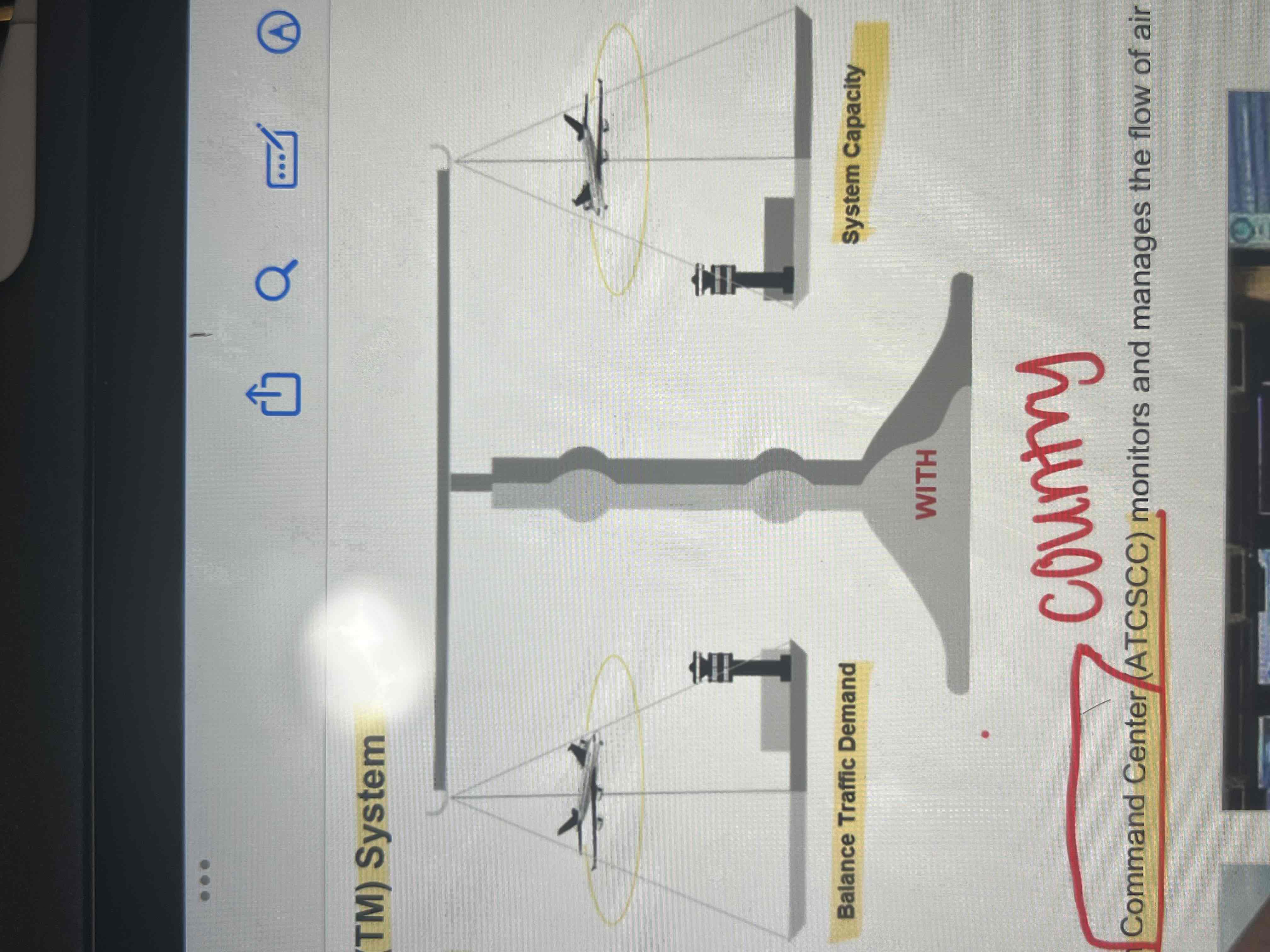
Managing the flow
Air Traffic Control System Command Center (ATCSCC) monitors and manages the flow of air traffic through the NAS
Traffic Management Units (TMU) monitor and balance traffic flows within their area of responsibility in accordance w traffic management directives
Traffic Management Initiatives (TMI)
Are techniques used to manage demand w capacity in the NAS
TYPES:
Altitude:
Tunneling: traffic will be descended prior to the normal descent point at the arrival airport to remain clear of an airspace situation
Capping: aircraft will be cleared to an altitude lower than their requested altitude until they are clear of a particular airspace
Miles-in-Trail (MIT) or Minutes-in Trail (MINIT) :
MIT is the number of miles required between aircraft that meet specific criteria, such as similar operating speeds
MINIT is the number of minutes required between successive aircraft
Fix Balancing or Airborne Holding
Fix Balancing is assigning and aircraft a fix other than in the field flight plan in the arrival or departure phase of the flight to distribute the demand
Airborne holding is planned holding normally done when the operating environment supports holding and the weather conditions are expected to improve shortly
Sequencing Programs
designed to achieve a specified interval between aircraft
assigns a departure time that to achieve a constant flow of traffic over a common point
En route sequencing assigns a departure time that will facilitate intervention in the en route stream
Assigns fix crossing times to aircraft destined to the same airport
Reroutes
routings other than the filed flight plan
Ensure aircraft “flow”
Remain clear of Special Use Airspace (SUA)
Avoid congest airspace
Avoid areas of known weather or where aircraft are deviating or refusing to fly
Ground Delay Programs (GDP)
aircraft are held on the ground in order to manage
Capacity and demand at a specific location be assigning arrival slots
Aircraft’s are assigned an Expect Departure Clearance Time (EDCT)
Ground Stops (GSs)
override all other traffic management initiatives
Most restrictive method
Aircraft must not be released w/o the approval of the originator of the GS
National Airspace System (NAS)
Is the airspace navigation facilities, and airports of the US along with their associated info, services, rules, regulations, policies, procedures, personnel, and equipment
Current NAS modernization program is known as NextGen
NAS components
airspace and Routes
Navigational Aids (NAVAIDs)
Airport and Landing Areas
Aeronautical Charts
Rules, Regulations, and Procedures
Personnel and Equipment
Airspace
Class A : airspace is reserved for high altitude travel en route from airport to airport
Class B: airspace surrounds the nation’s busiest airport
Air Traffic Service (ATS) Routes
Term used to identify the various types of routes and airways used by pilots for navigation.
VOR Airways and RNAV Tango Routes: used for navigation below 18,000 feet mean sea level (MSL)
Jet and RNAV Q Routes: used for navigation between Flight Level (FL) 180 and FL 450
NAVAIDs (Navigational AIDS)
Used for:
navigate from point to point
Provide approach aids landing
Can be:
ground based
Satellite-based
Primary NAVAIDs for the nations airway:
VOR
VORTAC
Tupes of Flight Rules
Visual Flight Rules (VFR)
Instrument Flight Rules (IFR)
VFR/IFR describe:
flight rules that pilots must follow
Flight plans that pilots should file
Weather conditions
Visual Flight Rules (VFR)
Conducting flight under visual conditions.
aircraft must remain clear of clouds to ensure good visibility
Instrument Flight Rules (IFR)
Govern the procedures for conducting instrument flight.
Under IFR:
ATC maintains separation from other aircraft, terrain, and man-made objects on the ground
IFR is required when weather conditions are below VFR minimums
pilots must be IFR certified