EESC 313 - Management of Watersheds (after Midterm)
1/124
There's no tags or description
Looks like no tags are added yet.
Name | Mastery | Learn | Test | Matching | Spaced | Call with Kai |
|---|
No analytics yet
Send a link to your students to track their progress
125 Terms
Watershed
An area of land bounded by topographic features that drains water to a shared destination such as lakes, streams, estuaries, and oceans. It captures precipitation, filters and stores water, and determines its release.
Advantages of a watersheds approach
- Natural unit of the landscapes Nested watersheds form landscape hierarchy
- Delineates biophysical units that are recognizable and function as unique input/output system
- Ideal unit for monitoring and measuring change Facilitates modeling, mass balance calculation and determining fluxes
- Process focus: quantity, quality, sediments etc.
- Integration tool: interaction between users & stakeholders can be examined
- Cumulative impacts & indicators for ecosystem health
- Understanding of complex systems
- Planning and modelling tool
Hierarchy Theory
- "Decomposable" structure (different order)
- Slower behaviour at higher levels (because the size are bigger)
- Discontinuities are common (organizational, spatial and temporal scales)
ecosystem property
Structure: spatial heterogeneity, aquatic/terrestrial. Dynamics/variability: disturbance/recovery. Resilience/thresholds. The amount of disturbance as system can absorb and still remain within the same state or domain of attraction: control variables and thresholds and linkages and complexities.
Impediments of watershed approach
- Management and policy: need long-term management and policy commitment where political commitments are only over 3-5 yr horizons
- Boundary difficulty: political and watershed boundaries rarely coincide making water management decision difficult
- Extrapolation from one watershed to another is difficult: each watershed is unique
- Scale issues
- External issues: these issues affect water quality and flow regimes but can not be controlled from within the watershed. These include global climate change, unusual climatic events, water diversion (inter-basin transfer) and atmospheric pollutants
Multiple Use Concept
Refers to the management of various natural resource products or product combinations on a particular watershed. The relationship of several natural resource products to one another can be complementary, supplementary, or competitive. Conceivably, several products on a particular land management unit can be complementary, supplementary, and competitive with one another. Effective management should accommodate the full spectrum of today's needs while providing for tomorrow's requirements
To incorporate multiple use into management
- on-site measurements of yields of natural products for alternative systems
- knowledge of the benefits and costs associated with each alternative
- recognition of the externalities, the off-site impacts
Groundwater
water held underground in the soil or in pores and crevices in rock that are fully saturated
Aquifer
a body of porous rock or sediment saturated with groundwater
groundwater flow is controlled by
- subsurface topography
- distribution of hydraulic conductivity
- climate (determining recharge source)
resulting three types of flow systems
Local, intermediate, and regional: determined by the relative locations of the discharge and recharge areas
Event flow
Water that enters a surface-water body promptly in response to individual water input events (e.g. rain or snowmelt)
Interflow
Subsurface flow that enters streams quickly enough to contribute to event responses. Typically more slowly than surface runoff but more rapidly than baseflow.
Pre-event flow
subsurface-stored water, resulting from previous precipitation events
Baseflow
Water that enters a stream from persistent, slowly varying sources and maintains stream flow between water-input events. Most from groundwater flow, some from lakes or wetlands.
five mechanisms of fast subsurface contributions to streams
- return flow
- translatory flow
- groundwater ridging
- macropore flow
- soil-bedrock interface
return flow
interflow that encounters a seepage face and becomes overlandflow
translatory flow
Also known as plug flow/piston flow. Occurs when the antecedent conditions of soil reaches field capacity.
groundwater ridging
A process that occurs in sloped drainage basins where the water table begins to rise near the stream channel more quickly than it does further away, creating a groundwater ridge close to the stream.
Macropores
void spaces in the soil that provide preferential pathways fro water to escape from capillary force and move downslope.
soil-bedrock interface
Soil layer is considerably more permeable than the underlying bedrock. Rainwater or snowmelt infiltrates rapidly to the bedrock interface and then moves rapidly downslope along the interface.
water table
The upper surface of the zone of saturation. It is the most dynamic boundary of the groundwater flow system. The configuration of this changes continually in response to recharge to and discharge from the groundwater system.
capillary fringe
the subsurface layer in which groundwater seeps up from a water table by capillary action to fill pores
Larger-scale hydrologic exchange controlled by
- relation of stream stage to adjacent groundwater level
- geometry and position of the stream channel within alluvial plains
- distribution and magnitude of hydraulic conductivities within the channel and the associated alluvial-plain sediments
Large scale direction and rate depend on
____ of the exchange processes depends on the hydraulic head, ___ depends on the hydraulic conductivity
High precipitation
overland flow and interflow increase, infiltrating the banks and recharging the aquifer (i.e., water table lower than streamflow, influent mode)
low precipitation
baseflow in many streams constitutes the discharge for most of the year (i.e., water table higher than streamflow, effluent mode)
flooding
river loses water to bank infiltration, also infiltrating and recharging the aquifer, resulting in bank storage
dry seasons/drought
release of bank storage compensates for a decrease in stream discharge. Can exceed the groundwater discharge in some river reaches.
Perennial streams
Baseflow is more-or- less continuous, flowing and being effluent throughout the yea
intermitten streams
streams receive water
only at certain times of the year. Either effluent or influent
ephemeral streams
Groundwater level always beneath the channel
hyporheic zone
Biogeochemical activities,
permitting significant
mineralization of organic nutrients. Habitat of stream fauna.
Water Mining: concept
Water withdrawal from an aquifer is greater than the recharge for a long term, it is referred to as water mining. Because an aquifer is an underground body filled with water, water mining, therefore usually refers to groundwater mining. Other terms: overexploitation, overdraft, excessive use, over pumping
water mining impacts
- land subsidence
- lake area shrinking
- contamination
- stream baseflow decline
- salty baseflow decline
- etc.
What is Surface Water and Groundwater integration?
development or contamination of one commonly affects the other
why do we care about Surface Water and Groundwater Integrations?
- water resource assessment and management
- contamination transport or aquifer vulnerability to contamination
- location ot low recharge areas for water disposal sites
Water balance method
Surface--waterbody
- Channel--water budget, seepage meter, base-flow discharge
Unsaturated zone
- Lysimeters, Darcy's law
Saturated zone
- Water-table fluctuation, Darcy's law
environmental tracing
Surface water body
- Heat tracer
- isotopic tracers
Unsaturated zone
- Applied tracers: 3H, visible dyes
- Environmental tracers: chloride PCp = DCuz; D= PCp / Cuz P: precipitation; D: drainage
Saturated zone
- Environmental tracers: chloride
Numerical Modelling
- MIKE-SHE: MODFLOW / MIKE 11(DHI)
- FeeFlow--MIKE11(Germany)
- WATFLOW: University of Waterloo, Canada
- HydroGIS
Methods of quantifying Mountain System Recharge include
• Water balances
• Chloride mass balances
•Environmental tracers (Deuterium, Oxygen 18, etc)
• Temperature profiles
• Numerical modeling
Evapotranspiration
- Warming intensifies evaporation
- Warming accelerated transpiration for
cooling
- Warming climate prolongs growing season
Vapour Pressure Deficit
- a measure of how much more "room" there is for humidity (water vapor) in the air, at the current temperature.
- increases with rising T due to more "room"
carbon dioxide
- Elevated ___ generally leads to reduced stomatal conductance in most plants
- Subsequently reduced transpiration rates
- Physical mechanism remains unresolved
Variations in watershed responses
- Effects of multiple countering processes accumulate
- Polarized pattern resulting from climate changes (e.g., more precipitation in wet watersheds, while less in dry watersheds)
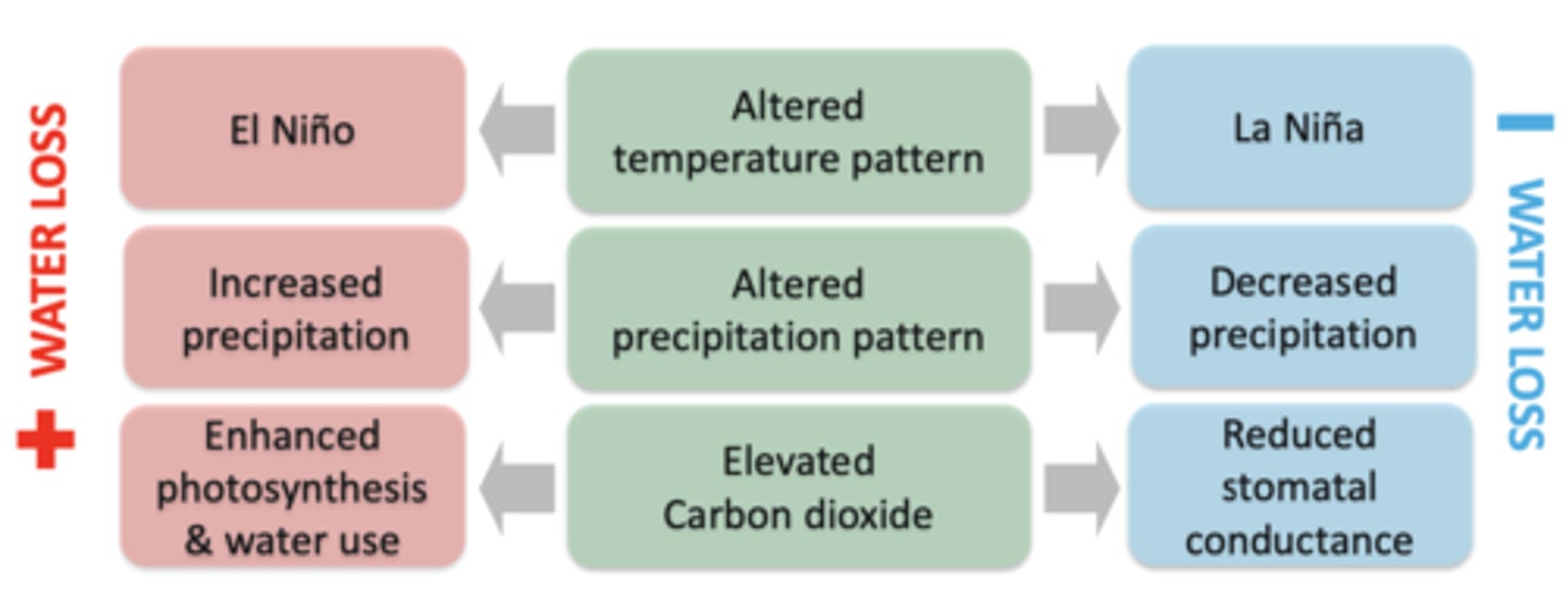
Decreased streamflow
- usually in snow-dominated watersheds or in water-limited
watersheds, especially in dry seasons
- Due to less precipitation (e.g., less snow accumulation and
rainfall due to warming) & increased ET
Increased streamflow
- in rain-dominated watersheds
- a greater increment in precipitation than in ET
climate change-induced disturbances
- amplified forest disturbances due to climate change
- Biotic disturbance, such as insect pathogens
- More fires, drought, and winds
- Induced forest disturbances interaction, which can worsen the situation
Forest composition and structure
- climate changes would change forest composition and structure
- Coniferous species more sensitive to moisture stress, rapidly reducing its transpiration
- In the example study, in 1970s the area is composed of mostly coniferous species took up 98% but in 2013, its becoming half coniferous and broad leaf and as a result of that there can be a significant increase in Datta flow as a result of the change in composition
Watershed Planning
is about integration of science, policy, and public participation in watershed management. It involves an integration of three major sets of elements: Objectives: based on problem analysis and directives from government and other stakeholders Constraints: budget, biophysical limitations, social, cultural and political conditions Techniques or methods
planning steps in watershed framework
- Involve relevant stakeholders or local partnerships
- Define watershed problems and management objectives
- Determine the appropriate watershed scales and collect data (data not always perfect)
- Identify management alternatives (option 1,2,3, etc.)
- Evaluate tradeoffs among alternative solutions and select the best option (cost/benefit analysis, risk assessment, multiple account evaluation and watershed computer models)
- Implement and monitor the plan
Planning Approaches
- top-down: governments oriented. Effective planning, but may not easily be implemented
- Bottom-up: grass-root communities oriented. Public participation and easy modification/ implementation, but planning is not effective (no expertise, no direction and limited funds)
- Integration: a better one
Emerging planning issues
- fragmented agency authorities and missions
- No integrated planning framework exists
- Agency roles in planning process are unclear
- Unclear tradeoffs definition for stakeholders
- Local resistance to "owning planning process"
- Science and technology shortcomings: Inadequate watershed and ecological science, and Fragmented data and models.
The role of science
- defining problems and objectives from a robust knowledge base
- Selecting alternatives and scientific data collection
- Evaluating tradeoffs and uncertainty among the alternatives
- Monitoring
- However, the incorporation of sound science in policymaking and planning is often easier said than done.
ten watershed lessons
- the best plans have clear visions, goals and action items
- Good leaders are committed and empower others
- Having a coordinator at the watershed level is desirable
- Environmental, economic, and social values are compatible
- Plans only succeed if implemented
- Partnership equal power
Good tools are available
- Measure, communicate, and account for progress
- Education and involvement drive action
Build on small successes
What is a watershed assessment?
is a process for evaluating how well a watershed is working. This process includes steps for identifying issues, examining the history of the watershed, describing it features and evaluating various resources within the watersheds. In a way, this is like a screening for human health
Features of watershed assessment
- problems and specific purposes
- An integrative nature: partnership and inter-disciplines
- Indicators: responsive and responsible, measurable
- Integration method: scoring, GIS, Models
- Scales: spatial and temporal
- Assessment results for decision-making or actions
- The most challenging task is the integration
Why watershed Assessment?
it can help us accomplish the following goals:
- Evaluate possible watershed impacts of proposed practices
- Identify opportunity for restoration activity
- Understand the cumulative impacts of land management practices over time
Watershed assessment in forested watershed in BC
- a brief history of the BC WAP Implementation of fresh practice code
- Concern over long-term sustainability
- WAP must be done before forestry activity in sensitive and community watersheds
Watershed assessment process (WAP)
- six components; WAP must be done by hydrologists
- Watershed advisory committee (technical group)
- Compilation of existing information
- Field assessment: peak flow and hydrological recovery; sediment source survey; reconnaissance channel assessment procedure; riparian assessment
- Watershed report card: a tabular summary of the filed assessment results
- Watershed report: a comprehensive report by the hydrologist
- Forest development plant recommendations
1. Peak flow and hydrological recover
Historical flood frequency, natural disturbance regime and implications on peak flow; opening (ECA) by elevation band: road network
2. Sediment source survey
Type of disturbance (landslides, gully, terrace bank etc.) location of disturbance; origin (road, clear-cut, natural); sediment delivery; degree of re-vegetation on disturbed areas
3. Reconnaissance channel assessment procedure
To select channel reaches to identify changes in stream morphology
4. Riparian assessment
Logged riparian areas; identification or reaches where riparian vegetation has a critical role in channel stability; presence or absence of large woody debris
1. Percentage of watershed harvested, corrected for ECA (%)
2. ECA by important elevation band
3. Total road density (km/km^2)
4. Length of road as high sediment source
5. Total number of landslides entering streams
6. Length of road as high sediment source
7. Number of streams crossing
8. Length of stream with non-functional riparian forests
9. Length of stream with distributed steam channel
Washington watershed analysis
- key steps: process overview; start-up; resource assessment; synthesis; prescription-writing; monitoring
- Course assessment: mass wasting; surface erosion; hydrology; riparian; stream channel; fish habitat; water quality; water supply/public work; routing
Oregon Assessment components
1. Start up and identification of issues
2. Historical conditions assessment
3. Channel habitat type classification
4. Hydrology and water use
5. Riparian/wetlands assessment
6. Sediment source assessment
7. Channel modification
8. Water qualify assessment
9. Fish and fish habitat assessment
10. And 11: condition evaluation and monitoring plan
Low Impact Development (LID)
is an innovative stormwater management approach with a basic principle that is modelled after nature: manage rainfall at the source using uniformly distributed decentralized micr-scale controls. It's goal is to mimic a sites' predevelopment hydrology by using design techniques that infiltrate, filters store, evaporated and detain runoff close to its source
Why watershed restoration in BC?
- An increasing incidence of landslides and debris flows to streams on the coast, and surface erosion and sediment transport from expanding road systems in the interior;
- An increasing incidence of eroding stream banks, and sediment-infilled stream channels
- A high frequency of culverts blocking or impairing passage of juvenile fish into seasonal off-channel refuge (tributaries, groundwater channels, ponds and wetlands); and
- An increasing loss of riparian functions and large woody debris
the importance of riparian zones
- LWD inputs
- Bank stability
- Shade
- Organic inputs
- Filtering
- Flood relief
Issues from previous forest practices
- initially the cutters are flat against the stream bed but the flow velocity increases with the culvert scoring out anything below
- So the height increases and the fish now have to jump up and move forwards
- This makes it very difficult for fish, so these culverts become fish barriers
- The fish cannot conduct spawning
Objectives of watershed restoration
watershed restoration is the process of returning a damaged watershed ecosystem to a close approximation of its condition prior to disturbance
- Although restoration can be used as an effective tool to return a damaged system to a pre-disturbance condition, it is also an important tool for preventing environmental degradation
- On many cases, restoring an ecosystem to an early pristine condition would be impossible
- Restoration is an internal part of a broad, watershed-based approach for achieving water resource management objectives
BC watershed restoration program
- the program funded through FRBC under forest practice code, was founded in 1995. It is a strategy to implement a program of rehabilitative and preventative measures, accelerating natural recovery process by restoring, protecting and maintaining fisheries, aquatic and forest resources adversely impacted by past logging practices, which would otherwise require several decades to recover naturally
- Ministry of environment and ministry of forest managed the stream and hill-slope components, respectively
Restoration Techniques
fish access: Log/debris jam removal, Debris/rockslide removal, Restoring access at culverts.
Stream banks: Rock method, vegetative methods, Integrated method.
Large woody debris-boulder complexes (log-jam habitat)
Boulder clusters
Pool-riffle reconstruction
Fertilization
Off-channel habitats
Large Woody debris Jams
- site specific
- Replace lost roughness elements
- Habitat oriented
- Rearing, spawning
- Triangular configuration
- Ballasted
- Stable channel requires
Boulder Clusters
- habitat focus
- Size rock to stream
- Place in riffles
- Rearing habitat
- Stable channel
- Diamond configuration
Riffle restoration
- process oriented
- Repeating units: riffle - pool
- Space according to size of stream (6 x W)
- Size of rock to size of stream
- Restore bed profile and habitat features
- Stable channel
Channel Restoration
- Floodplain included
- Longer term focus
- Not ballasted
- Dyke setback, re-meandering, roughness elements
- Stable or unstable channel
Off-channel restoration
- habitat oriented
- Surface or groundwater fed
- Engineered
- Spewing or reassuring focus
- Stable or unstable channel
- Maintenance intensive
Fish Passage restoration
- replacement or augmentation
- Engineered
- Can be very cost-effective
- Maintenance
- Ownership
Riparian Restoration
- long term
- Planning, thinning, brushing
- Key part to integrate with other approaches
- Maintenance
Paradigm Shift
- focus on key watersheds
- Conduct watershed system analysis
- Target at sources of problems
- perhaps the best restoration strategy is prevention
What is water?
- a unique resource
- because of this nature, an integrated ecosystem perspective is required for research and management
- our fragmented responsibilities against this nature (very limited coordination)
modern management approaches
- top-down versus bottom-up
- participator management
- supply versus demand management
- ecosystem management
- adaptive management
ecosystem management
- concept: integrating scientific knowledge of ecological relationships within a complex socio-political and values framework towards the general goal of protecting native ecosystem integrity over the long term
- too broad to be applied: who has mandate to implement this?
- studies are underway to make EM to be an operational management approach
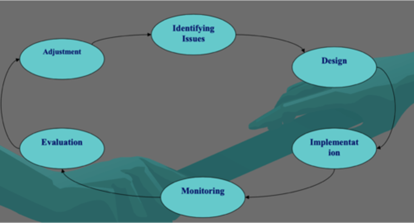
adaptive management
- identifying issues
- design
- implementation
- monitoring
- evaluation
- adjustment
IWM Five elements
- integrated basin-wide law and policy
- empowered provenance model
- improved basin-wide scene
- financial mechanism
- integrated information/data network
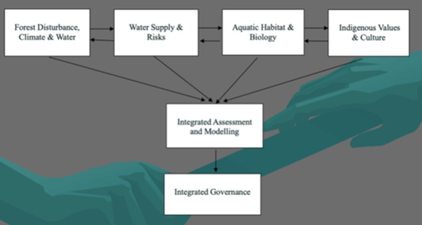
Watershed Ecosystem project: integrated science and governance
- forest disturbance, climate and water
- water supply and risks
- aquatic habitat and biology
- indigenous values and culture
- integrated assessment and modelling
- integrated governance
IWM five elements
- integrated basin-wide law and policy
- Empowered Governance model (organization, collaboration and participation)
- Improved basin wide-science
- Financial mechanism ($$)
Integrated
- information/ Data network
Okanagan Watershed
- dry, southern interior of BC
- connected to Columbia river
- Drainage area = 8,200 km^2 (in Canada)
- Mainsem lakes: 4
Okanagan lake: 120 x 7 km (largest lake)
- Four administrative districts
Hydrology of Okanagan Basin
- average annual precipitation: 300-450 mm
- Average annual net runoff: 76mm
- Majority of net annual runoff occurs during spring freshet as a result of melting winter snowpacks from elevations above 1200 meters
- Intra-annual climate: mismatching between energy and water
Key industry sectors of Okanagan
- Agriculture (75% of consumptive water use)
- Tourism
- Forestry and others
key concerns for Okanagan
- water
- ecosystem services
- future development opportunity
Science experience
- Okanagan basin study in 1969-1973; Canada-BC Okanagan Basin Implementation Agreement (1974) for the implementation of the particulars of 45 recommendations. This study provides key strategies for the basin-wide water management
- Okanagan basin water supply study (in 1994); the study estimated the limit of 61,000 dam^3 for future licensing
- Climate change study (2002—)
- Water supply demand analysis (2004—)
- Others: water quality, fish, groundwater, fire impact and forestry, fish-water management tool
Science gaps
- A new Okanagan basin study is overdue according to the recommendation from 1970'2 basin study
- Is a new Okanagan basin study needed??
- There are many knowledge gaps in specific processes
- There is also an important gap in integration methodology
- To a larger extent, the watershed is still treated as a "black box"
Legal mechanism experience
- Canada-bc Okanagan basin implementation agreement (1974)
- Various enforceable regulations (i.e. no new water licences for tributaries)
- Strategic and operational plans (LRMP, Regional Growth Strategy; OCPs)
Legal Mechanism gaps
- No full implementation of the 1974's agreement
- Lack of an Act for basin-wide management
Governance model haves:
- Okanagan water board
- Implementation for the recommendations of the basin study (1969-1974)
- Limited $$ and narrow work forces
- Limited power
- Fragmented regulations
Governance model needs:
- New Okanagan water board/council
- Implementation of basin-wide regulations
- Financial mechanism
- Appropriate representation and participation
- New basin-wide law
Information network haves:
- Discussion on establishment of the network
- Data of various formats and sources
information network needs:
- A GIS web-based information network
- Consistent formats
- Continuous upgrading
- Easy access
- A single location