Geophysical systems D1.1
1/51
Earn XP
Description and Tags
Name | Mastery | Learn | Test | Matching | Spaced |
|---|
No study sessions yet.
52 Terms
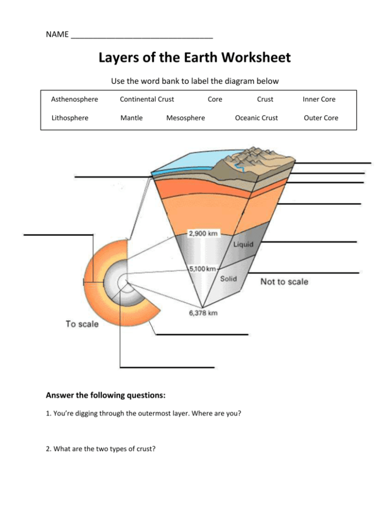
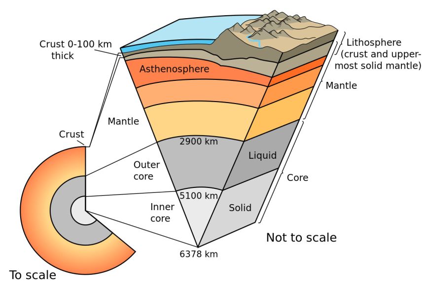
Earth Structure
Inner core
Solid metal (iron) and nickel
Outer core
Liquid metal (iron and nickel)
Spins around inner core to create earth magnetic field
Heat of core is result of frictional forces + radioactive decay of elements - generates 44 trillion watts of heat to flow away from core into mantle
Mantle
Solid rock
Upper mantle = asthenosphere
Is ductile/malleable and in places it is semi-molten
Crust
Made up of oceanic and continental plates
Varies in depth 3-70km
Oceanic crust = thin, young, dense, heavy - made from basalt rock
Continental crust = thicker, older, lighter - made from different rock types (mostly granite)
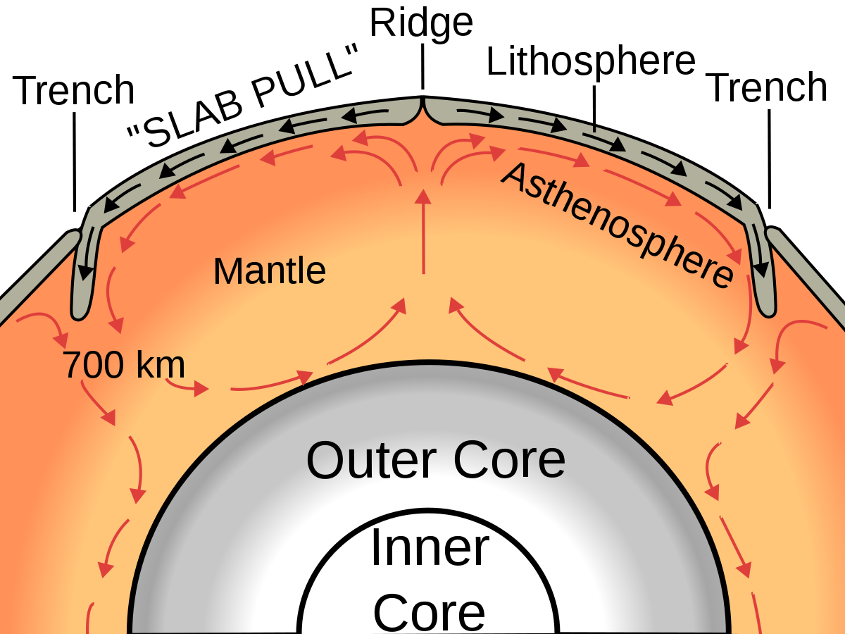
Plate movement
Earth crust = made from number of large plates + small plates
Plates are in constant movement - in a process called continental drift
Plates move at slow speed - 2-5cm a year
3 key factors that drive plate movement
convection cells
ridge push
slab pull
Convection cells
Mantle convection is slow creeping motion of earth solid rock caused by convection currents carrying heat from the interior to the planets surface
Earth surface + Lithosphere are dragged by frictional forces as convection moves sideways through the asthenosphere
Lithosphere
Made up of rigid crust and the more ductile upper part of the asthenosphere
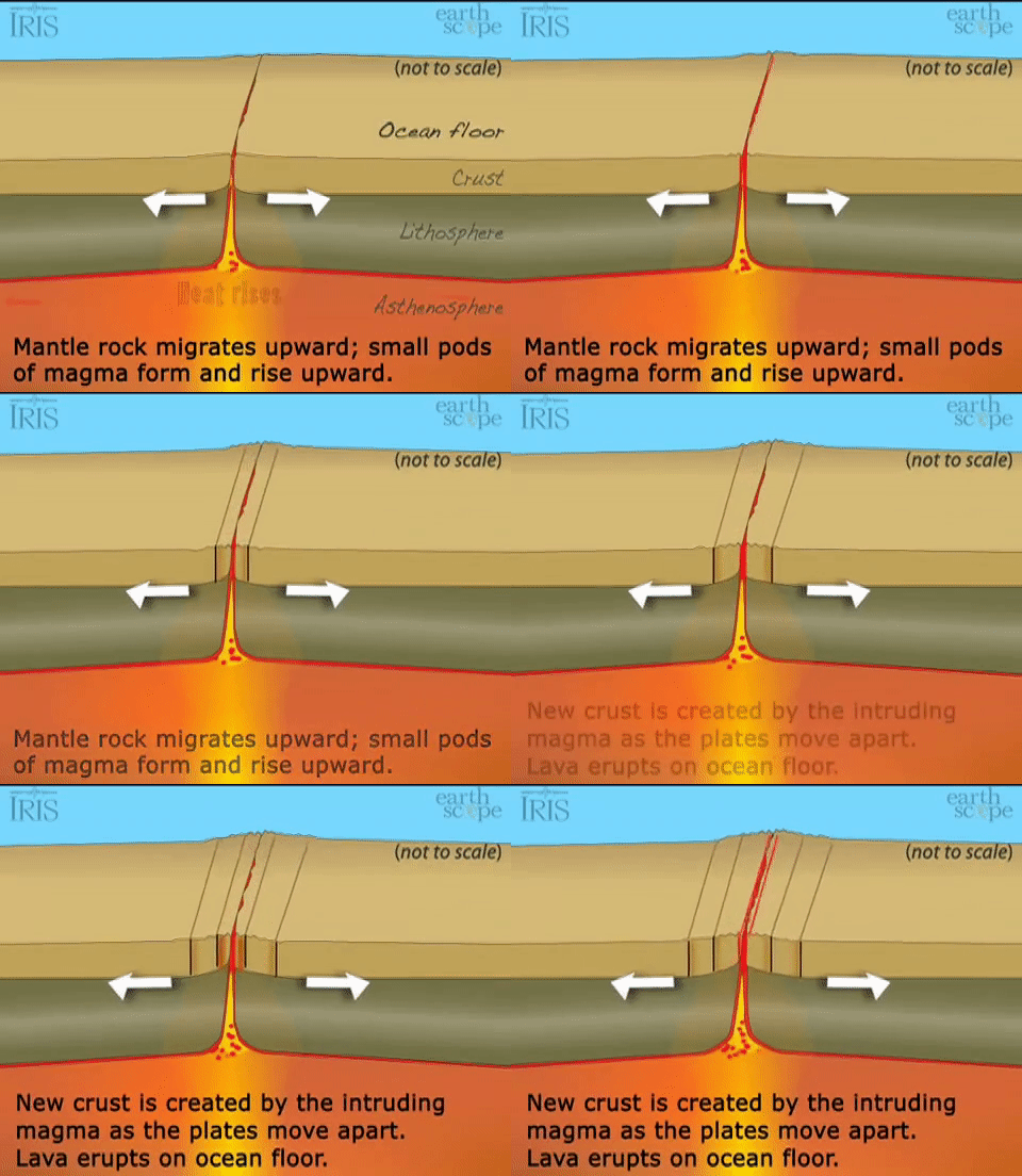
Ridge push
At rift zones, crust is moving apart under tensional stresses
The shearing of the crust reduces pressure on asthenosphere that allows mantle rock to form magma
Which rises upwards through the rift zone to form new ocean crust in the lithosphere
Lithosphere thickens with distance + time away from the mid-ocean ridge
This is because it cools as it moves away from the ridge + the boundary between the solid lithosphere and the plastic asthenosphere becomes deeper
Result of thickening away from ridge is a downward slope away from ridge
The weight of lithosphere on slope produces a downslope force allowing for it to push the older crust creating tis movement away from the ridge.
Rift zones
Found at ocean ridges and in continents
Rift zones are areas of weakness in the volcano which form early in its lifetime
likely due to spreading of the volcano as it settles
This linear area that is being rifted, or pulled apart, remains active through most of the volcano's building stages.
Mantle Plumes
In some locations in the mantle, there are upwellings of hot rock
Hotspots
As the heads of mantle plumes can partly melt when they reach shallow depths, they are thought to be the cause of volcanic centres known as hotspots and probably also to have caused flood basalts.
Flood Basalts
A flood basalt is the result of a giant volcanic eruption or series of eruptions that cover large stretches of land or the ocean floor with basalt lava
Many flood basalts have been attributed to the onset of a hotspot reaching the surface of the earth via a mantle plume
An example of a hotspot can be seen below in Hawaii.
Slab Pull
As lithospheric plates move away from mid-ocean ridges they cool and becom denser
Eventually they become denser than the hot mantle
During subduction — cool, dense lithosphere sinks into the mantle under its own weight
Because it is denser than mantle around, process of subduction continues
So, weight of subducting plate + force of gravity drives continental movement = slab pull
Slab pull considered most important factor causing plate movement
Subduction zone
At a subduction zone where two plates meet the denser of the two plates sinks under the other in a process called subduction.
Where do volcanoes occur
destructive (convergent) plate boundaries
constructive (divergent) plate boundaries
hotspots associated with mantle plumes
Destructive Plate Boundaries - What type of volcanoes
Associated with composite or strato-volcanoes that produce more explosive eruptions
Hotspots - What type of volcanoes
Associated with shield volcanoes - but can result in all forms of volcanoes
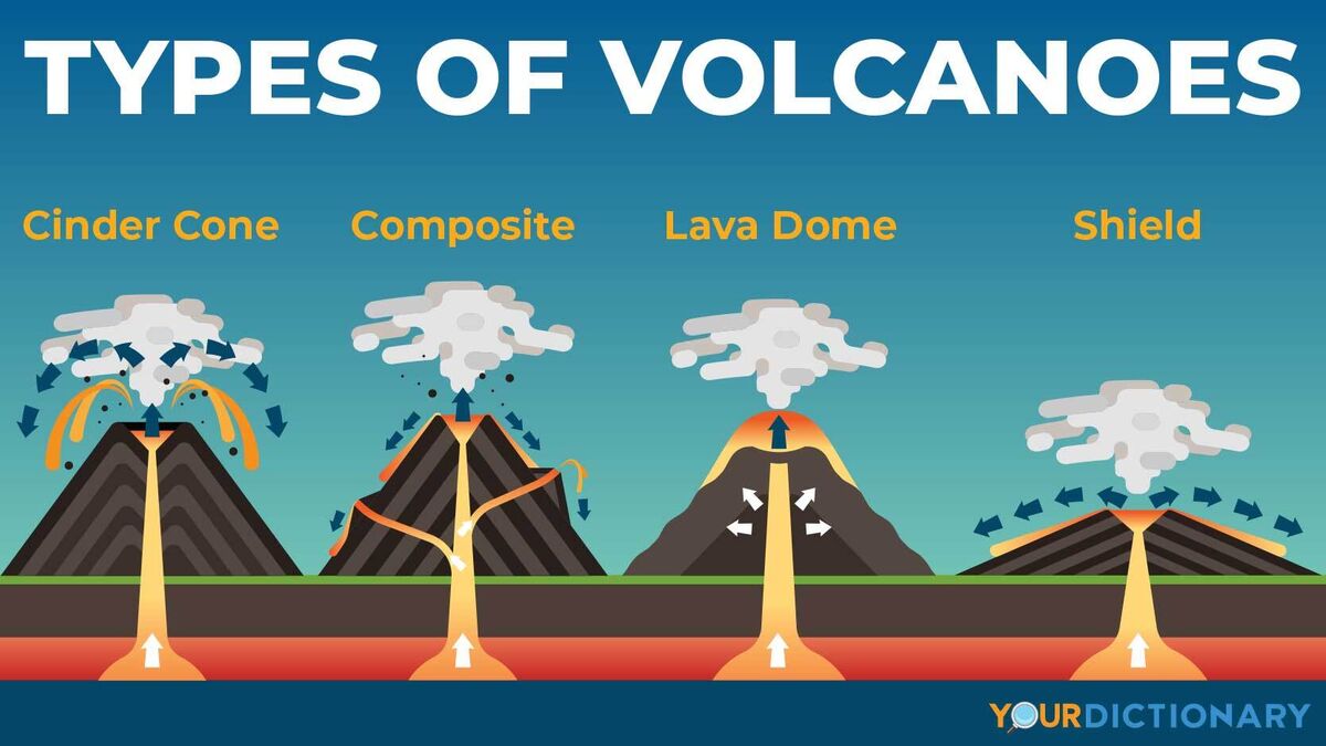
Types of volcanoes
Cinder Cone
When runny, low silica magma contains a lot of disolved gas, it could form a cinder cone
Gassy eruptions - sputter like soda spraying from a shaken can
They give loose volcanic fragments called cinders which settle and stack in a conical shape
Eg. Paricutin - Mexico
Composite/strato
Gas pressure in viscous, high silica magma can trigger explosive eruptions of loose magma fragments.
Less explosive eruptions create short lava flows that cover the fragments
Layers of lava and fragments build into a quintessential volcanic shape
Most often found on the edges of continents where oceanic crust descends beneath the thicker continental crust
Magma rising from deep boundary = plenty of time to drop out silica poor components and pick up silica rich ones
Eg. Mount fuji - Japan + Mount St Helens - Washington
Lava Dome/volcano
large depression formed when a volcano erupts and collapses
During volcanic eruption - magma present underneath the volcano is gotten rid of, often forcefully
when magma chamber empties - support that magma provided disappears
Found everywhere
Eg. Yellowstone national park in USA + Mauna Loa in Hawaii
Shield
Low silica magma - flow readily and puddle on land
Over time - eruptions form layers of lava like paint - creating a broad flat shield volcano
Often found in oceans
Since oceanic crust is thinner than continental, magma does not have to traval as far to reach surface - less time to change its composition and become silica rich
Lava in shield volcanos most resembles magma in earth
Eg. Muana Kea + Mauna Loa = Hawaii
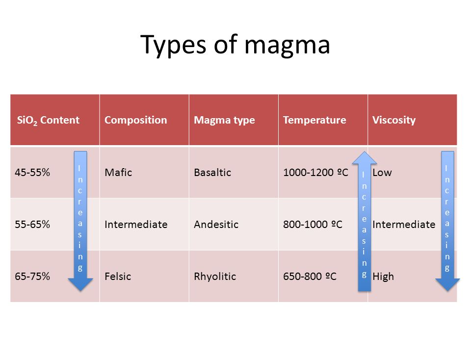
Types of magma
3 types of magma = different characteristics
Basaltic forms at constructive boundaries and hotspots over oceans - temperature is hottest + has lowest silica content
Rhyolitic is common at destructive plaete boundaries is cooler + greater silica content = makes it thicker and more viscous which is resistant to flow. — This magma traps gas and produces highly pressurised eruptions
Magma
Magma is produced when rock in the upper mantle melts
Because it is less dense than the rock around it - it rises upwards
What does low silica content mean
This means that it is more fluid in form and produces faster-flowing lava
It also allows for gas to more easily escape and so eruptions tend to be less violent with smaller ash columns.
Ocean-to-oceanic margins + Oceanic-to-Continental margins
Two types of destructive plate boundaries where subduction occurs
How island arcs form when the denser oceanic crust subducts under lighter.
Subduction of dense oceanic crust under lighter continental crust
In both = subducting crust under sinks into the softer asthenosphere
Carries hydrated sediments (matter that settles to the bottom of a liquid) and rock - so this water lowers melting point of rock found in the mantle wedge
This process causes melting of the mantle wedge and partial melting of the crust leading to magma

What is silica?
Most important compound in magma
Influences the explosiveness of eruptions
When magma rises up through crust, silica compound increases in concentration
this happens for 2 reasons
1. silica-poor compounds crystallize, gain density and sink
silica rich compounds crystalize slower
2. when magma rises it assimilates more silica-rich compounds in the surrounding rock + higher up in the crust = more silica rich rock is found
magma rising upwards in continental crust - due to greater depth - will get more silica
Silica rich compounds increase the viscosity of magma + trap more gas
Thus, eruptions at destructive plate boundaries are more explosive
2 types of hazards from a tectonic event
Primary Hazards
Secondary hazards
Associated primary hazards from a volcano
Lava
2 types
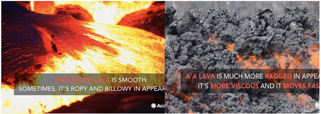
Pahoehoe
Smooth in its appearance
Low in viscosity and travels slowly
A’a
More rough in appearance
Higher viscosity and carries laval blocks called clinkers
Lava flow can lead to some secondary hazards like snow and glacier melt that can cause floods or glacial outburst floods called jokulhlaup and forest fires
Ash and Gas
Powerful eruptions create ash columns that can shoot to max 12km
Then produce ash plumes that extend away from the volcano and result in ash fall that can affect places many hundreds of kms away
Ash can impact global climate if sufficient ash reaches top of stratosphere
Ashfall can asphyxiate (kill) people and livestock
When ash mixes with rainfall the flanks (side of volcano) of the volcano become unstable - creating rapid moving mudflows called lahars
Gases emitted include a lot of co2, sulfur dioxide, hydrogen sulfide, and hydrogen halides
depending on concentration, gas = potentially hazardous to people, animals, agriculture and property
Eg. 1986 Lake Nyos in cameroon - Large volumes of volcanic gas made out of co2 were suddenly released from depth of lake which killed livestock and people
Pyroclastic Flows
Occurs when superheated gas, pumice and ash fly down flank of volcano
These flows can reach speeds of several hundred km/h
They vary in speed - 20-70km per hour
Temperatures vary from 200-700 degrees celsius
They form when the upward force of the blast is weak + part of ash column collapses down the flank of the volcano
Composition has a surge (Pyroclastic surges are low-density currents of ash, pumice, crystals, and volcanic gases that are more dilute than pyroclastic flows) at the front, heavier blocks and ash at the base and lighter ash and gas above
Pyroclastic flow will knock down nearly anything in its path
Associated secondary hazards from a volcano
Landslides
When pressure within magma chamber is large - leads to lateral blasts
Where flank of volcano becomes unstable and collapses
leads to block and ash flow called rock avalanches
Scale of events can be extreme
Eg. 1980 - Mount St Helens eruption = 2.3 billion cubic meters fell from mountain destroying more than 600km2 of territory and millions of trees - Rock avalanches can also cause floods and tsunamis when they hit rivers/water
Lahars
Occurs when large quantities of water mix with fallen ash
Water can come from torrential downpours (rain that comes down very fast) caused by ash particles in the atmosphere but also from snow melt or dam failure
When water mixes with ash - rivers will turn into mud and stones
Lahars can run for a long distance away from volcano - destroying everything in their way
Lahars vary in size + speed
Small lahars are less than a few meters wide + several centimeters deep - can travel at slow speeds
Large lahars = hundreds of meters wide + tens of meters deep - can travel at fast speeds
Can go up to 100km per hour in speed
Flow distances of more than 300km
Eg. 1985 - Nevado del Ruiz eruption - lahar caused by snow melt - in Colombia - Deaths = 23,000
Earthquake characteristics + why/how do they occur - stress
Take place most often at conservative plate boundaries where two plates slide past each other rather than away or towards each other - but can happen at all types
Those with the highest magnitudes occur at destructive plate boundaries where subduction takes place - tend to be less frequent
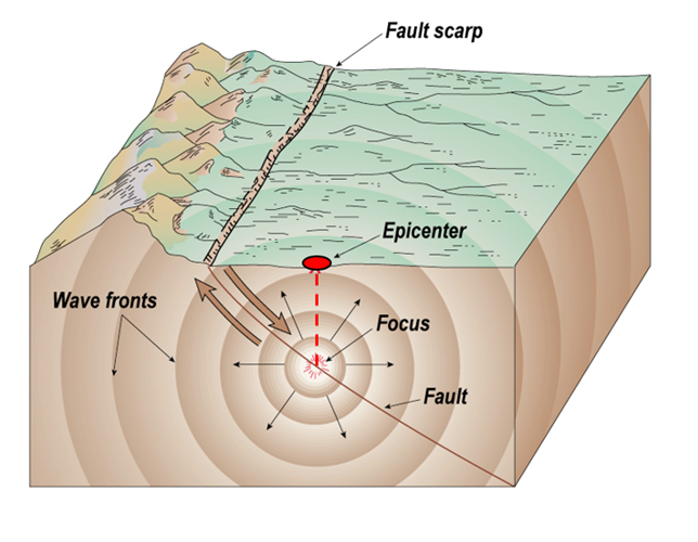
Occurs when the fault suddenly releases stored stress
When stress is released from the focus of the fault - seismic waves transfer the energy in all direction
Focus - area where stress is released
Epicentre - point directly above the focus and is where the energy on the surface will be greatest
Seismic waves = move away from the focus
Types of faults
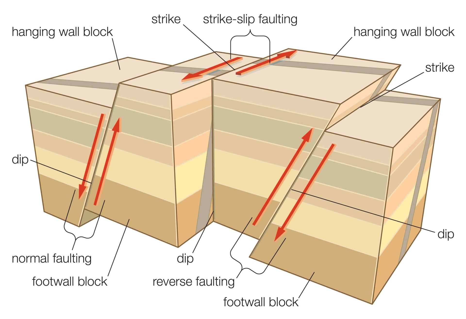
Normal
reverse
strike-slip
Why do earthquakes occur - magma
Earthquakes are also caused by rising magma in chambers within volcanoes
Increased frequency of earthquakes in volcanoes = known to be important warnings before eruption
Earthquake frequency = increase with magma height within the conduit
Why do earthquakes occur - human activity
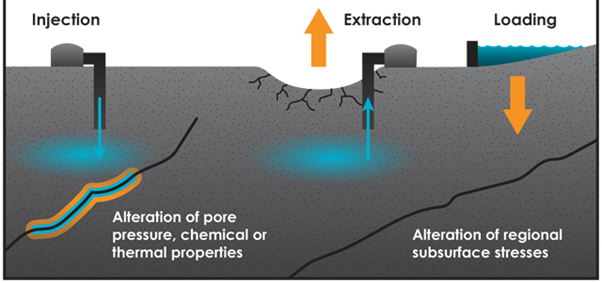
Human activity also cause earthquakes
Mining activities disturb rock structure
Use of dynamite and heavy machinery = cause earthquakes
Dam construction for reservoirs adds significant weight and loads to faulys and can also cause earthquakes
Fracking - shale gas is extracted from rock seams by injecting high pressures = increase frequency in earthquakes
Types of seismic wave
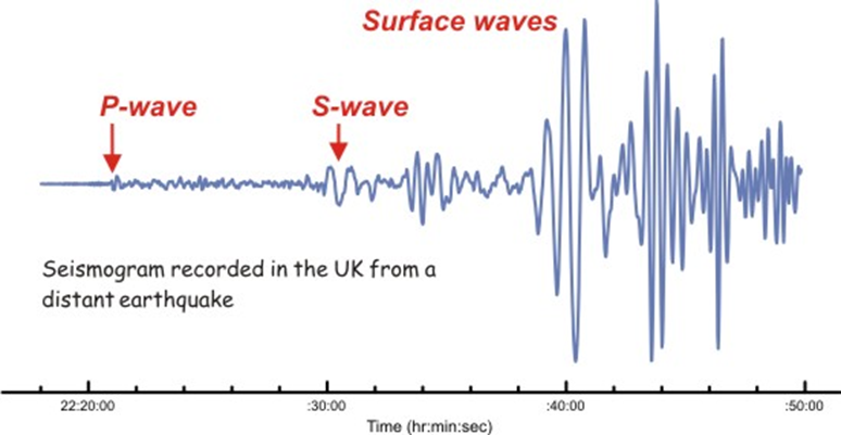
Can be scene in seismography
3 distinct types
primary/body
secondary/shear
surface
has two types:
love
rayleigh
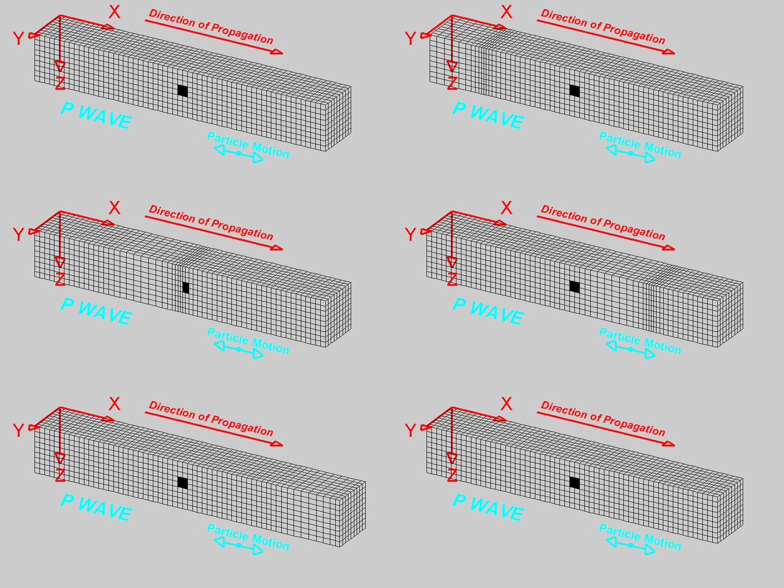
Primary waves
Alternating compressions (pushes) and dilations (pulls) move in the same direction
P motion travels fastest in materials
5-7km per s in crust
8km per s in earth’s mantle and core
P wave is the first arriving energy on seismograph
P—waves are generally smaller and have a higher frequency than the S and surface waves
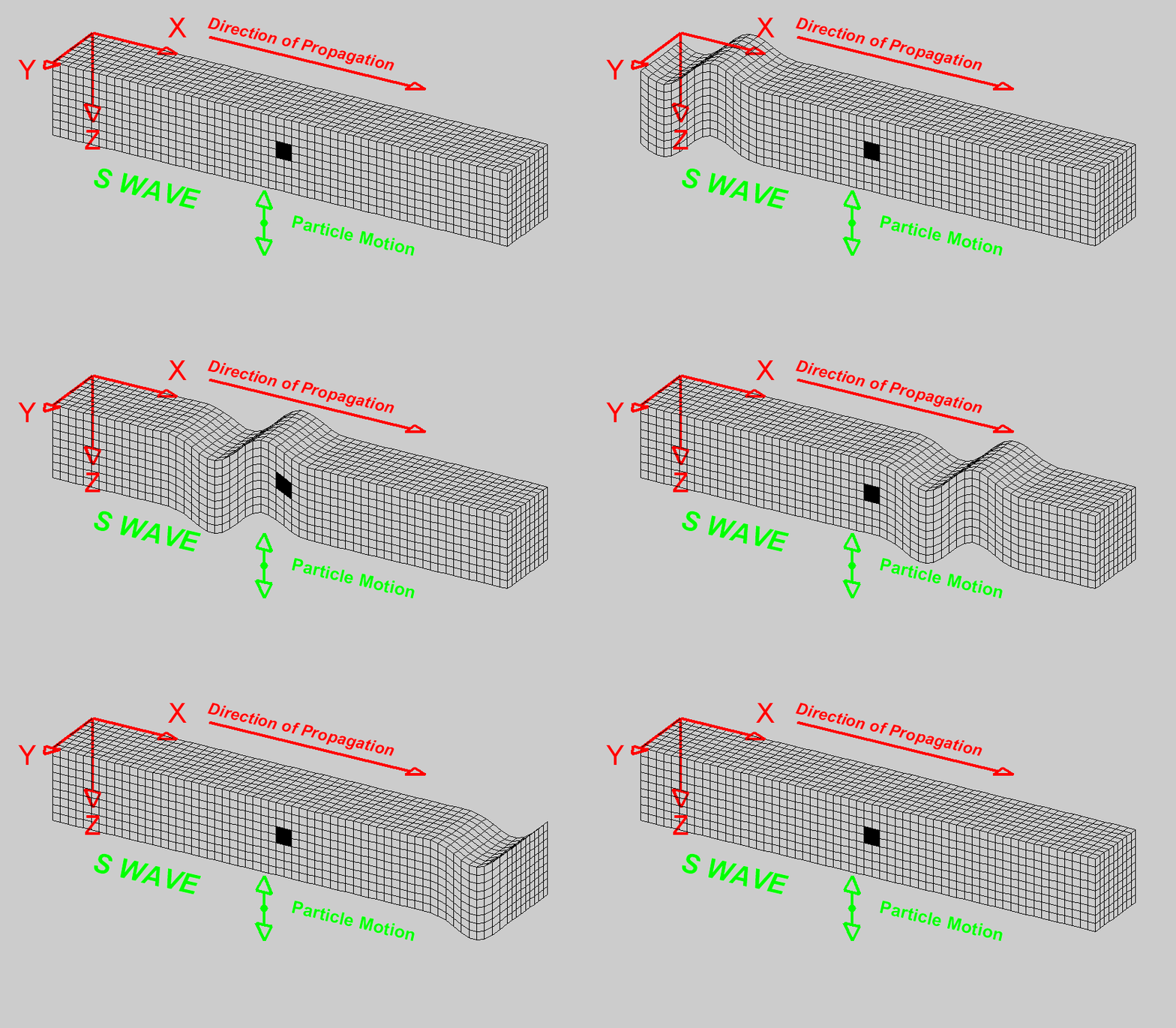
Secondary waves
Particle motion is in both vertical and horizontal planes
S-waves do not travel through fluids, do not exist in earth’s outer core or in air, water, or magma.
S-waves travel slower than p-waves in a solid
3-4km per s in earth’s crust
4.5 km per s in mantle
2.5 km per s in inner core
arrive after p wave
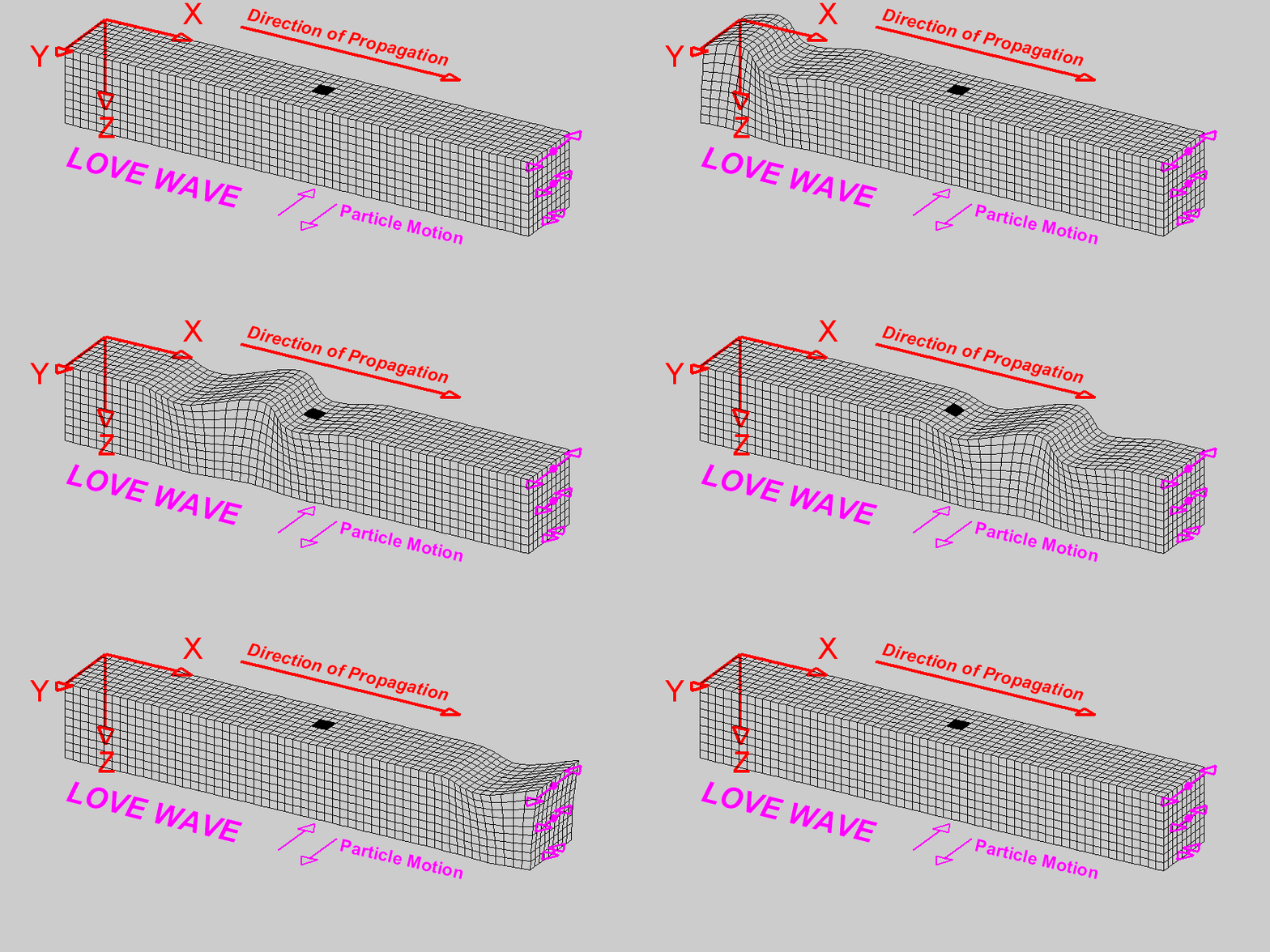
Surface waves = Love waves
Generally parallel to earth’s surface
They exist because of earth’s surface
Largest at the surface and decrease in amplitude and depth
They are dispersive
Wave velocity and depth are dependent on frequency
Generally, low frequencies propagating (growing) at a higher velocity and greater depth
velocity varies from 2-4.4km per s
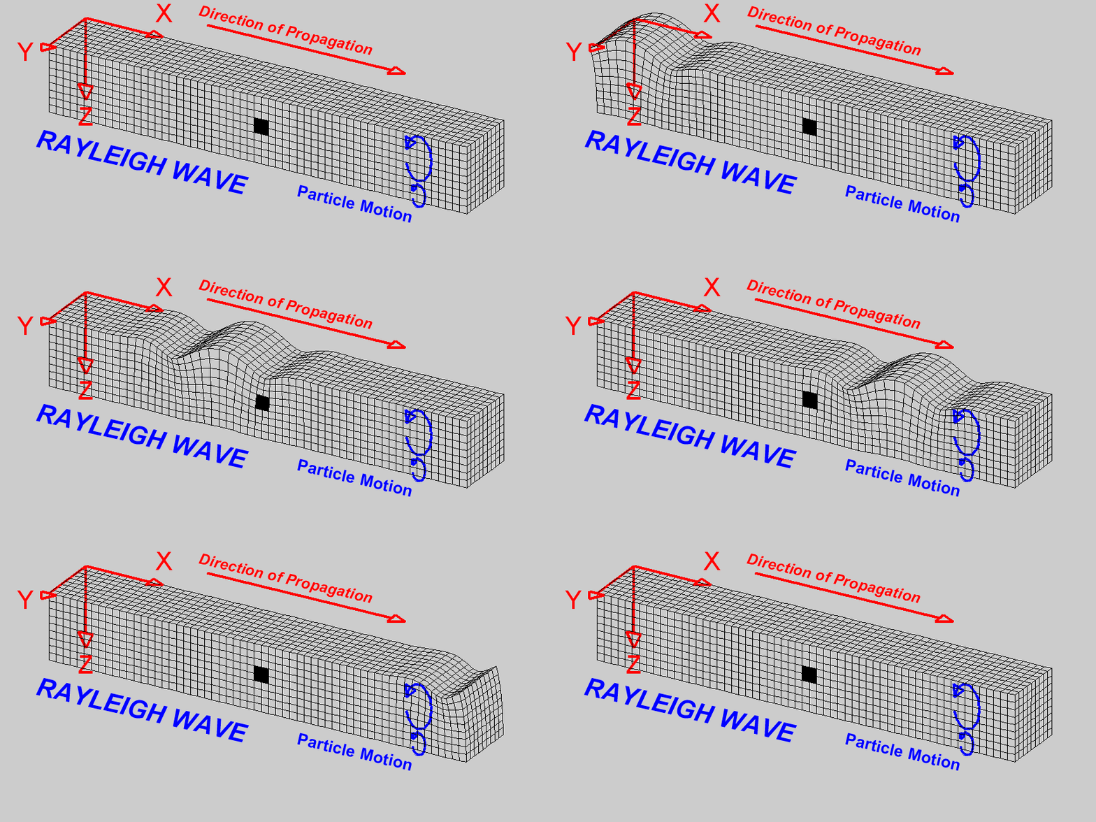
Surface waves = Rayleigh waves
Motion is generally elliptical
Waves are also dispersive
amplitudes generally decrease with depth in the earth
appearance and particle motion are similar to water waves
Depth of penetration of waves = dependent on frequency
Lower frequency penetration toa greater depth
velocity varies from 2-4.2km per s
Primary associated hazards of earthquakes
Directly linked to seismic waves
Earthquakes can cause movement of the surface - rolling and shaking
Brittle surfaces may fracture and infreasture = collapse
Collapsing buildings + bridges = considered primary hazard
Secondary associated hazards of earthquakes
Tsunami
Classified as a shallow water wave bc the wave is bigger than the depth of the ocean it moves over
Earthquakes cause tsunami - as a result of fault movement in a subduction zone
As oceanic plate = subducted — typically locks on to part of the continental plate and drags it with it
At some point the connection = broken + crust spring back in the direction of the ocean — this is a process called elastic rebound
Sudden movement of ocean floor around the fault leads to ocean displacement + series of tsunami waves
Eg. 2011 Japan tsunami - fault movement can be as much as 10meters = means that 10 meters of water is pushed upwards
Fires
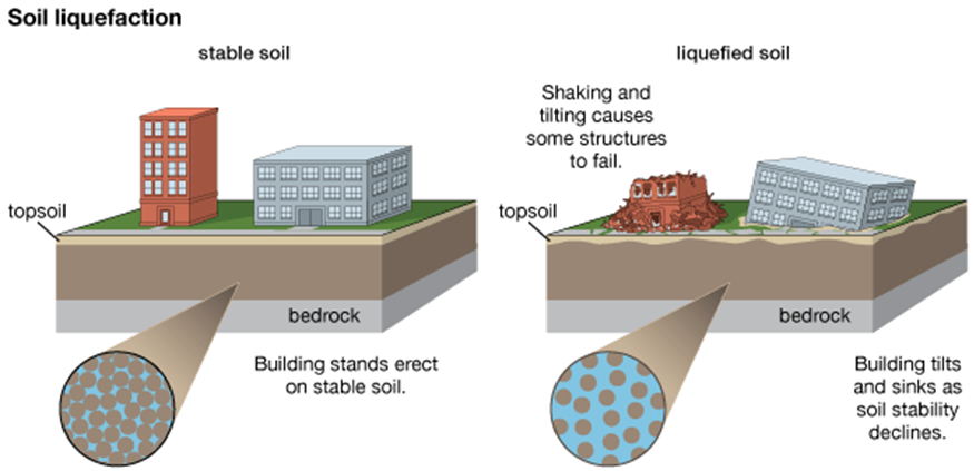
Liquefaction
Soil liquefaction also called earthquake liquefaction
Similar impact to landslide
Ground failure or loss of strength
Leads to soil behaving temporarily as a viscous liquid
Occurs in water-saturated soils affected by s waves
These waves cause ground vibrations during earthquakes
areas with poorly drained find-grained soils (sandy, gravelly soils) = most susceptible to liquefaction
Eg. 2010 earthquake Christchurch, New Zealand — Large parts of the centre liquefied close to the river banks - ground sank leading roads and buildings to subside
Eg. Indonesia, Sulawesi - Palu = liquefaction largely impacted
Landslides/avalanches
The stress exerted on unstable slopes leads to mass movement
Eg. Island of Hokkaido, Japan = 6.7 earthquake in 2018
Deep ocean vs Coastal tsunamis
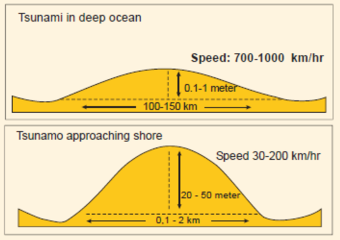
Tsunamis behave differently in open ocean compared to coast (where water is shallow)
Deep ocean:
long wavelengths
low amplitude - meaning wave crests are far apart
Look at diagram = wavelength is so great that in the deep ocean a ship wont notice the wave has passed
Also travels very fast
Approaching shore/coastal
tsunami slows down in speed
amplitude increases dramatically
base of the wave = slowed down by friction
Surface = less affected so amplitude of the wave increases
speed slows down as it travels into shallower water
Facts:
Waves that are unnoticeable in the deep ocean can reach 10-50 meters at the shore
Although they slow down they can still reach 200km per hour
Tsunamis are very powerful + have the ability to destroy everything in their path
Arrive in series of wave trains + with alternating deep waves and shallower
Examples
Indonesian earthquake and tsunami in 2004 = 9.0 on richter scale, major global impact (impact 18 countries) and 250,000 deaths
Japanese earthquake + tsunami in 2011 = 9.1 on richter scale caused a nuclear power station in Fukushima to leak radioactive waste and 20,000 deaths
Sulawesi in Indonesia = earthquake and tsunami in 2019 = 7.5 on richter scale, 4,500 deaths + produced dramatic liquefaction
What is a mass movement
classified in different ways
downward movement of material on a slope
consist of unconsolidated (loose) material - made of many individual pieces that act on each other to create a dynamic mass movement
Rock falls + avalanches = examples of unconsolidated mass movement
Can also one as one consolidated mass - ie. landslides
Slope stability depends on the balance between a number of forces
gravity - relates to steepness of slope
shear strength - relates to structure of slope + forces that maintain its stability
shear stress - refers to forces acting to reduce slope stability and lead to movement
Simply put - if shear stress is greater than shear strength and gravity and the angle of the slope is sufficient there will most likely be a mass movement - movement might be one bouler falling or a whole section of earth

3 most important factors influencing slope stability
gravity
slope angle
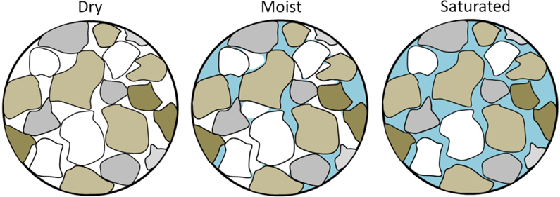
pore water pressure
refers to the weight of water within the soil or rock and its attempt to move downslope
water also acts as a lubricant causing more instability
in some cases, water enters pores between particles forcing them apart and reducing ability to bind
What human causes increase shear stress/reduce shear strength of a slope
deforestation
trees serve two functions
bind the soil increasing shear strength through their roots
reduce pore water pressure in slope by reducing infiltration by interception
house construction
undermine slope stability
be building houses on the slope = adds weight to the slope which increases shear stress
water infiltration may also be disturbed - may increase instability
road construction
building at base = undermine stability
consider this as removing the foundation of a building
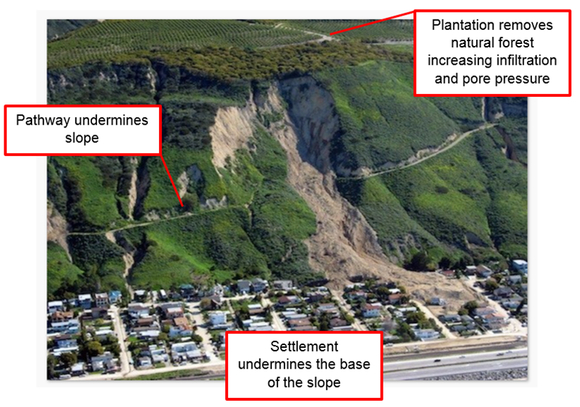
Causes of mass movements
Factors increasing shear stress:
Removal of lateral support - by undercutting or slope steepening
Eg. by rivers, wave action. previous rock falls
removal of underlying support - by undercutting rivers and waves, road construction
Loading of slope - through increased weight of water, debris, construction, water injection through mining
Lateral pressure - water and ice in cracks - swelling and pressure release
transient stresses - earthquakes, wind moving trees, mining
Factors reducing shear strength
weathering effects, disintegration of granular rock, chemical weathering processes
changes in pore water, saturation, softening of material pressure
changes in structure, creation of fissures in clays, remoulding of sands and clays
organic effects - biological weathering, decay of roots and burrowing animals
Classification of mass movements
based on speed of flow and degree of fluidity
Dry mass movements
eg. creep and rock slides which are based on unconsolidated materials are the slowest
Generally, the wetter the mass movement the faster its speed of flow - although there is a significant range in speed of wet mass movemetns
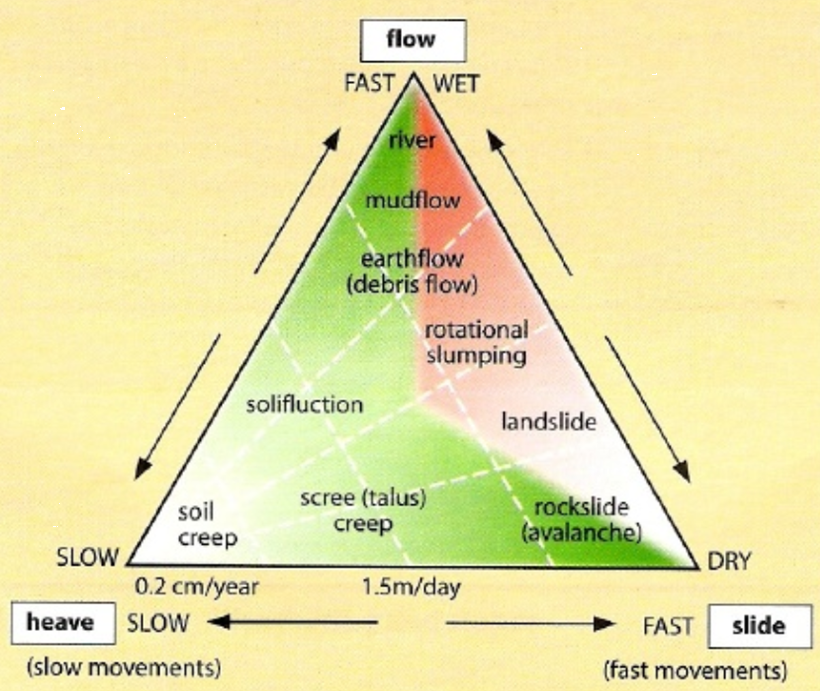
Slow mass movements
occur as a gradual process over time
eg. soil creep, scree creep, solifluction - occurs in regions of permafrost as the active later on the surface becomes more fluid and slowly moves downslope
Soil creep and scree creep = unconsolidated
solifluction is consolidated
Fast mass movements
can take different forms - classified as falls, topples, slides and flows
vary in speed and scale
rock fall begins as a rock - becomes separated from bedrock - as it falls it can set in motion an unconsolidated movement as one rock knocks into another
topples occur when the strata of the rock are unstable in their alignment to the angle of the slope
slides can be divided into
rotational
occur when a slump block, composed of loosely consolidated sediments slides along a slip plane
several characteristic features - slip plane is concave in its shape
causes original surface of the block to become less steep and the top of the slump is rotated backwards
main slump block often breaks into a series of secondary slumps and an associated scarp marks its original position
translational
follow a more linear axis of slip
debris flows = water-laden masses of soil and rock rush down mountainsides, funnel into stream channels and form hick muddy deposits on valley floors
generally have bulk densities
they can flow almost as fluidly as water
debris flows descending steep channels commonly go up to speeds that surpass 10meters per second
Correlation between frequency of mass movements and magnitude
Small scale movement that affect a small area occur more frequently
large scale movements whicha ffect large area occurs less frequently
however, also depends on physical and human factors influencing stability of the slope
Rifting
Splitting apart of a tectonic plate into 2+ tectonic plates separated by divergent plate boundaries
where is a divergent plate boundary
mid atlantic ridge and East African Rift
convergent plate boundary examples
include subduction zones such as the Japan Trench and the Peru-Chile Trench, where one tectonic plate is forced under another
majority of ring of fire
collision plate boundary examples
include mountain ranges like the Himalayas (india thrust into eurasian plate) and the Alps, where two tectonic plates collide and create uplift.
transform plate boundary examples
include the San Andreas Fault and the North Anatolian Fault, where two tectonic plates slide past each other.
Hot Spot / Intra Plate Volcanism examples
include the Hawaiian Islands and Yellowstone National Park, where volcanic activity occurs away from tectonic plate boundaries.
what is Intra Plate Volcanism
Intra Plate Volcanism refers to volcanic activity that occurs within a tectonic plate rather than at the boundaries. This phenomenon is often caused by hot spots in the mantle, leading to the formation of volcanoes away from plate boundaries.
It is characterized by the emergence of magma from the mantle, resulting in volcanic islands or features like those found in Hawaii and Yellowstone.