Meteology -- Chapters 8-9
1/29
There's no tags or description
Looks like no tags are added yet.
Name | Mastery | Learn | Test | Matching | Spaced | Call with Kai |
|---|
No analytics yet
Send a link to your students to track their progress
30 Terms
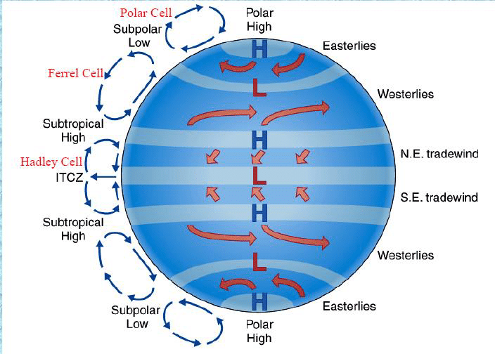
Be able to recreate the 3-cell model depicting general atmospheric circulation.
Be able to differentiate between Rossby wave troughs and ridges in terms of temperature, heights, shape, etc.
Troughs are colder weather, dip in upper air height, and low pressure. Ridges look like hills and they are warmer weather and high pressure, bump in upper aur heights.
Explain how a sea breeze works and describe its migration inland as the day progresses.
During the day, the land surface heats up faster than the water surface. Therefore, the air above the land is warmer than the air above the ocean. Now, recall that warmer air is lighter than cooler air. As a result, warm air rises. Therefore, the warmer air over the land surface is rising. As the warm air over the land is rising, the cooler air over the ocean is flowing over the land surface to replace the rising warm air.
Describe what happens when an El Nino forms in terms of the SOI, atmospheric pressure, precipitation, winds, ocean currents, and ocean temperatures. How is this different from normal conditions?
The SOI is negative, the atmospheric pressure switches locations, the precip. areas switch, ocean currents switch, winds weaken, ocean temps in the east becomes warmer.
Describe the weather changes when a cold front approaches and after it passes.
In front of the cold front it is warm with tornadoes and storms, when it passes the weather is cold.
Describe the weather changes when a warm front approaches and after it passes.
In front of the warm front you first see cirrus clouds then the clouds be progressively lower and thicker then rain comes, then after it passes the weather is warmer.
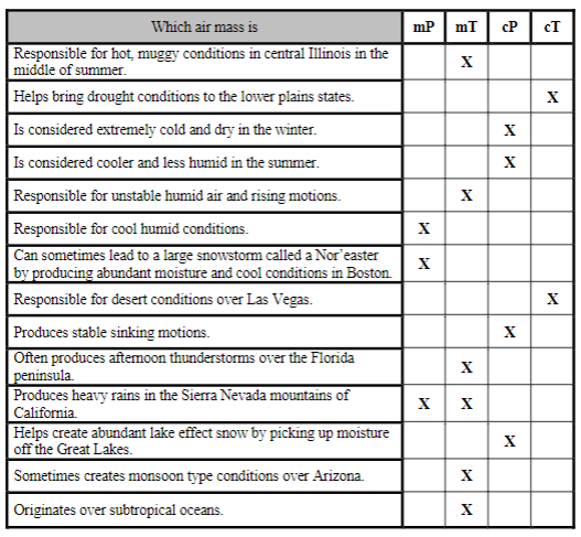
Be able to answer questions concerning different types of air masses and their locations.
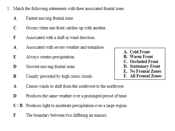
Be able to complete matching exercises identifying the different frontal zones.
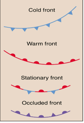
Be able to draw a cold, warm, occluded, and stationary fronts.
Semi-permanent pressure cells
areas of high or low-pressure that exist much of the year and can be found all over the globe.
Rossby waves (zonal vs. meridional flow)
Zonal flow follows a pattern along latitudinal lines, latitudinal circles or in the west–east direction. Meridional flow follows a pattern from north to south, or from south to north, along the Earth's longitude lines,
Monsoons
A monsoon is a seasonal change in the direction of the prevailing, or strongest, winds of a region. Monsoons cause wet and dry seasons throughout much of the tropics.
Foehn, Chinook, and Santa Ana winds
orographic induced, compression warming on leeward side, responsible for greatest 1-min temperature change.
Katabatic winds
cold, dense air flowing down mountain slopes, common is iceland/greenland
Sea breeze
cool breeze from water, during the day the land is hotter and lower pressure than water, wind blows from land to water, high to low pressure, breeze migrates inland as day goes on.
land breeze
during the night the land becomes cooler and higher pressure than water, wind blows from land to water.
valley and mountain breeze
differential heating of valley and higher elevations, diurnal wind shift, valley breeze blows up, mountain breeze blows down.
el nino
unusually warm water in the easter pacific ocean, 2-7 year occurrences.
la nina
strengthened “normal” conditions, much colder sea surface temps.
Southern Oscillation
pressure differences between western and eastern pacific (pressure switches), SOI index determines magnitude differences, negative values = start of el Niño.
Hadley cell
tropical cell driven by heat
jet streams
fast streams of air in upper troposhere
Rossby waves
long waves, transfers energy from equator and the poles.
fronts
boundaries between differing air masses
Nor’easter
New England storm caused by maritime polar air mass.
Cold Front
cold air advances toward warmer air, bringing cold and dry conditions, A steep angle produces intense rising motions, and heavy precip over a short period of time, can produce severe thunderstorms/squall lines/tornadoes, the fastest moving front.
Warm Front
warm air advances towards colder air, warmer air lifts over cold air, bring warmer and more humid conditions, shallow sloping fronts, produces stratus to cirrus clouds, light precip for longer duration.
Stationary Front
neither air mass moves, overrunning precip occurs on the colder north side of front, persistent weather can last for days, slowest moving front.
Occluded Front
When one front overtakes another, warm is forced aloft and storm weakens, point of occlusion is where storm reaches its max strength but can quickly weaken.
Dry Lines
boundaries with large moisture differences, can lead to severe weather and tornadoes.