AP Human Geography: Unit 4 Notes
1/149
There's no tags or description
Looks like no tags are added yet.
Name | Mastery | Learn | Test | Matching | Spaced |
|---|
No study sessions yet.
150 Terms
Political geography
The study of the political organization of the world.
State
A synonymous with a country. It has spatial extent, permanent population, has defined borders, a sovereign government (no other government in the world can tell what that government can do), and has recognition from other states politically.
Evolution of a modern state
Happened in the last couple hundred years. Early political states were bot well defined. Political power was based on relationships between a leader and a group of people. People living in the state were loyal to the king, not the country. Borders were unclear, poorly defined, and often changed.
Modern state concept
European political philosophers created that. People owed allegiance to the state and its people. Borders were drawn to formalize divisions between countries. European countries imposed these divisions on areas around the world as they colonized them.
35 countries
In 1776, how many countries were there?
70 countries
By WW2, how many countries were there?
Many colonies did the process of decolonization
After WW2, what happened to the many colonized?
Cold War
When was the second round of countries being decolonized?
195
How many states does the US recognize?
Nation
A group of people with a shared similar culture, a historical attachment to an area or homeland, and who seek some degree of political control over that homeland.
Nation-State
A state where the borders of a national group's homeland coincides with the borders of the state. Population is linked through common culture and history. Tend to be small and isolated. Example—Japan and Iceland, Denmark, Slovenia, Israel, Germany, France, Egypt, Albania, Poland, Portugal, Swaziland
Stateless National
National group spread out over several different states. It is the minority group in each state and has no to little political power in each state. Example—Kurds, Palestinians.
Multinational state
Country with several national groups within their borders. Often, one group is dominant and controls. Example—Canada, UK, Russia
Multistate nation
National group's homeland has a state of its own and also spreads across its borders into other countries. The national group controls political, economic, and social power in its own country and influences others. Example—Germans, Koreans, and Hungarians
Autonomous and Semi-authonomous regions
Areas inside a state.
Semi-autonomous regions
A moderate degree of self-government and freedom to govern themselves. Example—Hong Kong
Autonomous regions
A high degree of self-government and freedom to govern themselves. Example—Native American Reservation
Sovereignty, nation-states, self-detemination
Political geography changes over time is based on the concepts and processes with
Sovereignty
The right of a state to rule over itself.
Nation-state
The territory occupied by a particular nation of people is same as the recognized political boundary of that state. Example—France, Japan
Self-Determination
People have a right to govern themselves. Often a nation or ethnicity that wants to have its own state. Examples—Yugoslavia with the Balkan, stateless nations- Kurds, Palestinians, Basque;Catalonia (Spain)
Balkanization
To describe when a country splits into smaller countries. Example—Yugoslavia
Colonialism, Imperialism, Independence Movements, Devolution
Political geography changes over time is based on the concepts and processes along national lines such as
Imperialism
The larger idea of creating an empire by exerting force to control other nations often from afar, without needing to go there.
Colonialism
The actual practice of claiming territories and settling there to exert economic and social control. Examples—Spain with South America, Britain with South Asia, Berlin Conference with colonizing Africa
Independence movements
Group of people in a particular part of an area advocating for separation from large political entity on basis of ethnicity, religion, nationality, etc. Example—Catalonia, Spain, Scotland, UK, Kurds from Syria, Turkey, Iran, Iraq
Because many came from colonization, they push for independence Example—India with Britain
Many coming from history of colonization in that place, which causes those that were colonized to
Devolution
Breaking up of a state into smaller units or the passing of power from central to lower governments. From the federal to the more local government. Example—Catalonia and Basque- Spain, Yugoslavia into Balkan states, Quebec and Nunavut- Canada, Belgium, Nigeria.
Berlin Conference
Deciding which colonizers of Europe will get which countries in Africa.
Cultures and economies were destroyed
Results due to the decolonization and independence movements
Geographically as control over people, land, and resources
How is political power expressed?
Through territoriality
How do groups control people, land, and resources?
Neocolonialism
Many developed countries have exerted political, economic, and cultural power over developing countries.
Shatterbelts
Conflicts between larger political and cultural forces can cause regional problems in areas.
Chokepoints
Limit access to people, land, and resources making control of these access points crucial for countries
Territoriality
The connection of people, their culture, and their economic systems to the land.
Delimiting the boundaries of the area they claim, controlling people and their activities inside the area they claim, and defending the area they claim from external groups
Groups often express territoriality by
Conflicts as groups disagree over borders, practice different cultures, or have competing economic interests in the area
Territoriality can often lead to
Neocolonialism
Developed countries exert economic power over developing countries.
Often control the extraction of natural resources and the labor in former colonies.
Transnational companies based in the former mother countries often control?
They control the extraction of natural resources and the labor in former colonies, not the developed countries. Examples—Dominate oil extraction in the Middle East. Exploit cheap labor for factories in Southeast Asia especially by many different clothing manufacturers or other types of electronics.
Things foreign companies do
Loaned money to developing countries that they are unable to pay back, so they are kept in a constant cycle of debt
Why do foreign countries loan to developing countries?
Neocolonialism
Developed countries exert political and military power over developing countries.
Remained involved in political and military affairs of the developing countries to protect their interests. Example—US intervened in Latin America, Africa, Asia, and the Middle East
Developed countries have remained involved in?
Allows for military bases to be located inside their countries. Example—France inside West Africa
Treaties with former colonies allows for?
Neocolonialism
Developed countries exert cultural power over developing countries.
Lost their language as the people were forced to learn the language of the colonizers.
What happened with the original language with developing countries?
Convert people in developing areas resulting in loss of local culture beliefs.
What can missionaries do in developing areas?
Western clothing
The dominant form of dress worldwide.
Shatterbelts
Areas where larger regional or global political or cultural divisions collide and cause conflict at a local scale. Example—Cold war in Korea (control of peninsula), Europe (west and east divide), Vietnam (north fought non South) ; Religious conflicts India, Pakistan, Israel, and Caucasus Region because India is Hindu, while rest in muslim causing where to take the land.
Chokepoints
Areas where the physical geography creates a narrow opening, that makes it difficult for trade or other travel between two point.
Strait of—Hormuz, Gibraltar, Bosporus, Malacca
Important chokepoints
Strait of Hormus
Connects the Persian Gulf with the Arabian Sea.
Strait of Gibraltar
Connects the Atlantic Ocean with the Mediterranean Strait.
Strait of Bosporus
Connects the Black Sea and the Mediterranean Sea. It provides access to Southern Russia.
Straitt of Malacca
In Indonesia, that has the majority of trade flowing through that particular area.
Political boundaries
Divisions of governance between states and within them reflect balances of power that have been negotiated or imposed.
Relic, Superimposed. Antecedent, geometric, subsequent, consequent
Types of political boundaries
Relic boundary
Former boundary that no longer exists but still holds some kind of significance (economic, cultural, etc) Example—Berlin Wall (Was part of the Iron Cutrain and divided Europe in the Cold War)
Superimposed Boundary
Boundaries that are drawn by outside powers and tend to ignore existing boundaries of social, cultural, or ethnic differences. Example—Africa after Berlin Conference (consequences—internal/external conflict, ineffective government, multistate nation, multinational state, loss of culture.)
Antecedent Boundary
Boundaries drawn before many people live in an area and establish a cultural landscape. Example—US and Canada
Geometric Boundary
Boundary that follows a straight line, often latitude or longitude lines. Superimposed or Antecedent. Example—US and Canada, Parts of North Africa, Many states
Subsequent Boundary
Boundaries drawn where people have already settled with cultures already established (distinguished from antecedent). Example—Much of Europe
Consequent Boundary
A kind of subsequent boundary that is drawn to accommodate existing differences among people such as ethnicity, language, religion and more. Example—Balkans' lines drawn according to the nation after Yugoslavia, India and Pakistan when British drew lines so that the Hindus and Muslims not fight, Nunavut in Canada more autonomy, by giving their own territory.
Created to show limits of political power, define and enforce territoriality, create sense of place, regulate and control people, businesses, and resources inside the jurisdiction, regulate and control people and resources outside the jurisdiction
Purpose of boundaries
Defined boundary
Established by a legal document. Example—Treaty that seperates countries, legal document that shows property lines between houses.
Delimited boundary
Line drawn on a map that shows the limits of the government's jurisdiction.
Demarcated boundary
Identified by physical markers or barriers. Example—Town limit signs, walls or fences on a border.
Coincide with, cultural, national, or economic divisions
Political boundaries often coincide with
Followed linguistic lines
Boundaries drawn in Europe after WW1 largely followed:
Divided Muslims and Hindus
Boundaries between India and Pakistan, and India and Banglasdesh divided the
Those of national group homelands Example—England and Wales, Spain and France
Boundaries often match those of
Reflect economic divisions. Example—Borders between the wealthy and poor
Boundaries can reflect
Created through the use of demilitarized zones or through policies of other countries.
Political boundaries are created through the use of
Were drawn by the French and English and formalized in the Sykes-Picot Agreement after WW1
Boundaries in the Middle East were drawn by
Were drawn by European nations as a result of the Berlin Conference
Boundaries in Africa were drawn by
A demilitarized zone created as a result of the armistice ending the Korean war
The boundary between North and South Korea is a
Delimited and demarcated so people know where the boundaries are on the Earth
Defined boundaries must be
According to their definition
Boundaries are usually shown on maps according to their
Often "off" in their measurements
Surveyors using pre-GPS technology were often
Becomes hard to correct mistakes later on
Once boundaries are demarcated it becomes
Definitional (Positional), Locational (Territorial), Operational (Functional), Allocational (Resource)
Types of Boundary Disputes
Definitional (Positional) dispute
Conflicts over the interpretation of documents/treaties defining a boundary or the way it is shown on the ground. Example—Inaccurate maps of Andes due to border between Argentina and Chile.
Locational (Territorial) dispute
Conflicts between states or regions over the ownership of a given area. Example—Dispute over the ownership of the Rhineland between Germany and France.
Operational (Functional) dispute
Conflicts over the national policies applied at a border. Example—Visa requirements at the US-Canada border after 9/11.
Allocational (Resource) dispute
Conflicts over the use of resources created or complicated by a boundary. Example—Iraqi-Kuwait conflict over access to the Rumaiah Oil Field.
Influence national and regional identity. Both encourage and complicate interactions between groups.
Boundaries and treaties influence/both
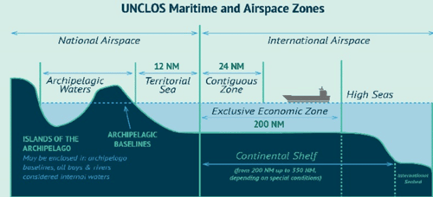
UNCLOS (United Nations Convention on the Law of the Sea)
Created to settle disputes between countries.
Discourage international interaction Example—Walls, fences, and buffer zones make it harder for people and goods to move across borders.
Boundaries discourage
Encourage and discourage international interaction. Examples—Agreements such as Free Trade Zones, the European Union, and the Commonwealth make border crossing easier for people and goods. Agreements like embargoes prevent interaction between countries.
International agreements
By borders and claims of countries.
Resources are complicated by
When countries cannot agree on the harvesting of a natural resource. Example—In the South China Sea's problems are a result of different countries' claims that the Spratly Islands are their own territory. ; In the Artic stem's problems comes from five countries' different interpretations over land and resource rights.
Resource disputes occur when
UNCLOS, (United Nations Convention on the Law of the Sea)
Regulates maritime boundaries and resources.
The territory of a particular country in the water is up to 12 nautical miles from the shore line/baseline on the shore.; A country's contiguous zone (a zone where not all laws apply) extends 12 to 24 nautical miles from shore.
UNCLOS establishes territorial claims which are
A country's exclusive economic zone extends 200-350 nautical miles from shore depending on the continental shelf.; Anyone can travel in international waters/airspace. International waters begin 12 miles off the coast of a particular country.
UNCLOS regulates resource claims which are
Form voting districts
Internal boundaries often form
By redistricting and gerrymandering affecting the politics and elections
Voting districts are determined by
Voting districts
Local geographic area of a larger country in which you vote for representatives to congress. Determined by redistricting after each census.
District level (may have a majority of a particular party, then those votes go towards a certain party) State & State level (Might have totally opposite majority of a certain party base for both state and country elections)
Scale matters in Voting districts because
Redistricting
Internal political boundaries that are redrawn after a census, which determine voting districts for legislatures. Example—Count where all the people are in those states, and then the government goes and based on that population they would redraw those districts.