Geology- Topography Test Review
1/20
There's no tags or description
Looks like no tags are added yet.
Name | Mastery | Learn | Test | Matching | Spaced |
|---|
No study sessions yet.
21 Terms
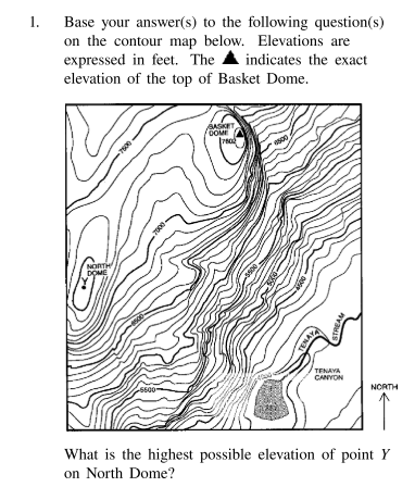
What is the highest possible elevation of point Y on North Dome?
7,599 ft
Which characteristics of Earth’s surface can be determined by using a topographic map?
hillslope and stream gradients
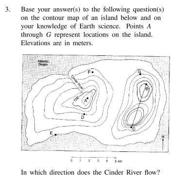
In which direction does the Cinder River flow?
Northwest

What is the contour interval for this map?
20m
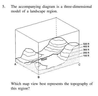
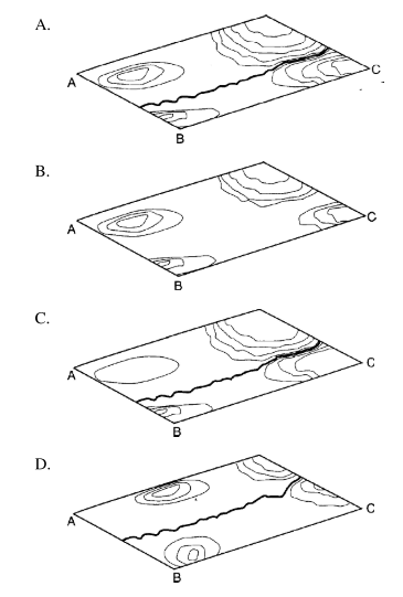
Which map view best represents the topography of this region?
A

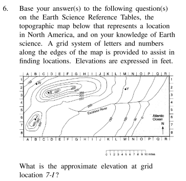
What is the approximate elevation at grid location 7-I?
170ft
If a person at point W (grid location 2-B) travels uphill, in which direction is the person traveling?
southeast
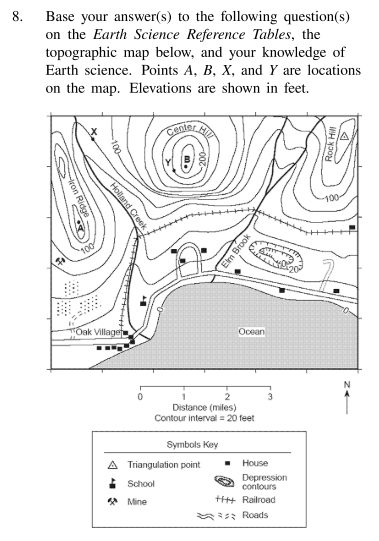
What is the approximate elevation of the triangulation point on the top of Rock Hill?
144 ft

In which section of the map is the highest elevation located?
northwest
Which locations have the same elevation?
C and I
a) state the general compact direction in which the stream is flowing
b) state how contour lines provide the evidence for determining this direction
a) north
b) the contour lines form a V. The ‘V’ tells us that the stream is flowing out of its mouth north.
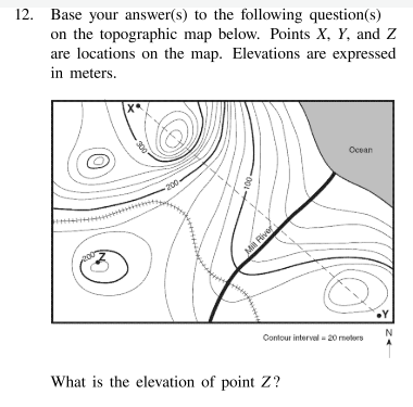
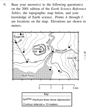
What is the elevation of point Z?
220 m
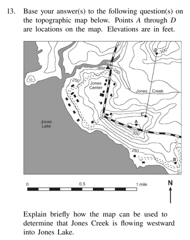
Explain briefly how the map can be used to determine that Jones Creek is flowing westward into Jones Lake.
The contour lines form a V. The V always points upstream. This shows us that the creek is flowing out of the V’s mouth (flowing northwest into the lake).
State how the shape of the contour lines crossing the Green River indicates that this river flows toward the southeast.
The contour lines form a V around the river. The V always points upstream. The mouth of the V tells us that the Green River is flowing southeast. (another reason could be that rivers flow from greater elevation toward lower elevation)

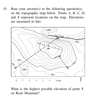
What is the highest possible elevation of point X on Rock Mountain?
1,699 ft
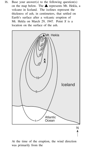
At the time of the eruption, the wind direction was primarily from the…?
north
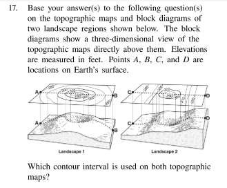
Which contour interval is used on both topographic maps?
10 ft
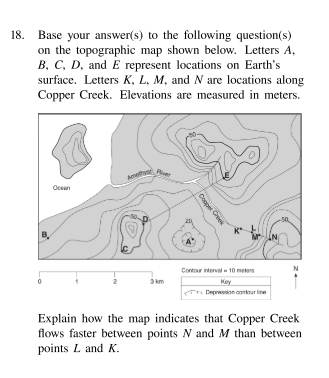
Explain how the map indicates that Copper Creek flows faster between point N and M than between points L and K.
Contour lines between N and M are closer together
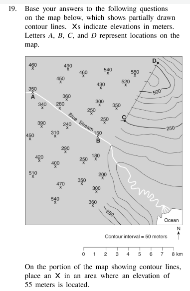
On the portion of the map showing contour lines, place an X in an area where an elevation of 55 meters is located.
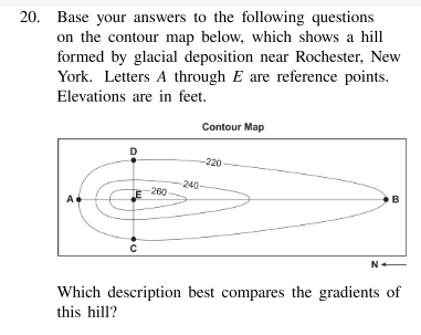
Which description best compares the gradients of this hill?
AE has a steeper gradient than EB