Lecture 10_Water and watersheds
1/44
There's no tags or description
Looks like no tags are added yet.
Name | Mastery | Learn | Test | Matching | Spaced |
|---|
No study sessions yet.
45 Terms
Criterion 4: Water Indicators
conservation and maintenance of soil and water resources; limited range of indicators
General indicator: area of forest with goal of protection of soil or water resources
Two Indicators directly related to water:
Proportion of forest management that meet best practices to protect water-related resources
Area and percent of water bodies or stream length in forest with significant change in physical, chemical or biological properties
Canopy Interception:
Direct Throughfall: portion of rainfall that reaches ground
Indirect Throughfall: intercepted by foliage or branches, rain will fall to ground as canopy drip, some will travel through branches to ground (stem flow)
Net Rainfall
The sum of throughfall and stemflow
Interception loss
remaining rainfall evaporates back to atmosphere, significant fraction of total precipitation
Rainfall in multi-tiered forest canopies
common in tropics and mature temperate forest
rainfall is intercepted at multiple levels: creates vertical cascade of potential losses to atmosphere
Unloading Process
Snow can be blown off branches or clumps of snow can fall of branches
Fog drip or occult precipitation
can be important additional source of water
it is water droplets dripping to ground from fog
Transpiration
The physiological process where plants take soil water from their roots and bring them to their leaves and then diffuses in atmosphere, 10% of total water atmosphere
Forests Influences on snow accumulation and melt:
varies depending on climate and topography
Holds snow in forest canopy which melts from inputs from atmosphere
reduces snow buildup through interception loss, 40% less accumulation under conifer forest than clear area
delays spring snowmelt and reduces the rate of snowmelt through shading from heat and sun radiation while also reducing wind speed
Hydrologic process on forest slopes: Macropores
present in soil, created by decay of old roots, animal burrows, erosion channels, and pockets of buried organic matter.
Secondary porosity which may dominate porosity of soil matrix (fine pore) for water transmission
What do Macropores create?
created preferential flow paths across hillslopes, promotes rapid percolation of infiltrating rainwater and/or snowmelt.
Forest soils is very permeable with saturated hydraulic conductivities (Ks) (in ) and A horizons) . Declines in depth because of increasing clay, compaction and lower organic matter.
Hydrologic processes on forested slopes: Post-fire hydrophobicity
after a fire organic matter migrate downward and coat mineral soil particulates, results in hydrophobic layer
This stops deeper percolation of water and produces overland flow and erosion of soil above hydrophobic layer
highest in first year or two after fire
Infiltration-excess overland flow
When water input exceeds the soil's infiltration capacity. This causes runoff, common in arid regions or in compacted soils.
water overland flow
this seepage of water is called return flow, because it infiltrated soil, flowed downslope, and then returned to surface to reach stream channel
Saturation-excess overland flow
When surface water input occurs in already saturated areas, leading to runoff.
Effects of forest management on hillslope hydrology:
slash burns and soil compaction could lead to overland flow
removal of forest canopy: influences hillslope hydrology
harvesting effect lead to drier soils under forest cover at end of summer
Watershed
An area of land where all water drains into a common body of water like a river, lake, or stream. Point of Interest (POI)
Runoff generation
Processes and pathways where water is brought to the stream channel
Depends also on precipitation regime, either rain or snow dominated
pathways have different velocities of flow, overland flow higher than throughflow
How do pathways of runoff differ chemically?
Overland flow has high organic and nitrogen content, while groundwater has higher mineral concentrations.
Streamflow regimes:
refers to seasonal distribution of streamflow, function primarily of the interaction between regional climate, vegetation and topography
depends also on elevation above sea level and rain regimes, soil conditions
The effects of forest harvesting
it differs among the different hydrologic regimes. like harvesting can be more complex in catchments (areas where water flows into resevoir) subject to rain on snow events than rain-domianted or snow dominated areas
Water Yield
total amount of water that leaves a catchment as streamflow over specific period of time (volume divided by catchment drainage area)
increases by harvesting
Peak flows:
Peak streamflow events are important components of channel’s streamflow regime,
Peak flows are needed to flush accumulations of fine sediment from the coarse bed sediments used for spawning by fish.
Harvesting effects are a great concern for peak flow
Harvesting effects on Peak Flow
can increase bed and bank erosion, sours salmonid spawning beds
Forest operations can also influence by changing timing of water inputs. Faster snowmelt from clearcuts can lead to reducing of peak flow by spreading snowmelt over longer period
Forest operation can also increase magnitude of peak flow
Hydrological recovery:
After a harvest: vegetation establishment influences hydrological process and eventually reduces magnitude of harvesting-related impacts
trajectory of recovery depends on: type of vegetation, growth rate, and successional processes
Chronosequence approach: a way to quantify recovery rates
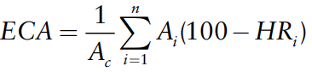
ECA
Equivalent Cearcut Area
it is to quantify recovery for assessing cumulative effects of multiple harvesting or other land-use activities in a watershed
7 challenges to ECA in forest management
different processes like snowmelt/accum/transpiration recover at different rates
shape of recovery curves for streamflow may not vary monotonically from 0 to 100%
magnitudes and duration vary depending on forest type
Focus on clearcut harvesting is less common, variable retention more common
not valid assumption that hydrological recovery make catchment will function the same prior to harvest
active forest management could change species composition
climate change could change stand characteristics and hydroclimatic regime of catchment.
Hillslope processes
Includes mass movements and surface erosion. Driven by gravity and can involve effects of flowing water.
Includes landslides, rockfall, soil creep, and dry ravel
Downslope displacement of soil and bedrock via falling, toppling, sliding, spreading, flowing, or combination of all
Surface erosion
The detachment, transport, and subsequent deposition of soil by flowing water
Sheet erosion
When rainfall exceeds soil’s infiltration capacity, causing overland runoff that is spread uniformly across a hill slope. Causing rill erosion and deepen rills and gully erosion.
not common on undisturbed forest hillslopes
Hillslope processes for forest road planning
Implement adequate road drainage measures
restricting the use of roads and trails during rainy and wet periods
Maintaining road surfaces and drainage systems
Road surfaces should be compacted and cut-and-fill slopes should be revegetated
Drains should not discharge onto erodible fill material or onto unstable slopes
Take in consideration drainage of subsurface flow that is intercepted by road
Hill slope processes on temperate forest
major adverse effect from forest harvesting on slope stability is due to loss of root strength/reinforcement
Recovery rate of regenerating trees are affected by tree species, harvesting season, site fertility, climate and environmental factors. Most vulnerable period is 3-20 years after clearcutting
How can forest roads destabilize hillslopes
altering hydrologic pathways and concentrating water unto unstable portions of hillslope
Undercutting unstable slopes which removes support
Overloading and oversteepening fillslopes, including road prism
What role do riparian forests play in channel stability?
They provide bank cohesion, trap sediments, and regulate stream temperatures.
How does sediment input affect stream channels?
Increased sediment can lead to aggradation, while reduced wood inputs reduce aquatic habitat complexity.
Channel processes and morphology: forestry operations
Forestry operation can influence this through their influences on the peak flow regime and on sediment inputs
What are the effects of harvesting on stream temperature?
Increased solar radiation raises stream temperatures, impacting cold-water species like salmonids.
How does sediment affect aquatic ecosystems?
Suspended sediment clogs fish gills, reduces oxygen flow in stream beds, and interferes with feeding.
How do riparian buffers help water quality?
They filter sediment, reduce erosion, and stabilize stream banks.
Thermal recovery
the rate at which stream temperatures recover to pre-harvesting levels, important for SFM, faster for narrow streams. Wider streams: taller vegeation is required
water quality recovery also depend on
Species that are established in the riparian zone after harvesting
The site’s climate, influences rates of vegetation growth
Sediment Yield
Total amount of suspended sediment transported out of a catchment by a stream in specific time interval
Water Chemistry
Forest Harvesting increases stream water concentrations of nutients like nitrate (NO3)
Post-harvest establisment of nitrogen fixing species like alder (alnus spp.) can increase nitrogen pool in soil.
Riparian zone
The ecotone between aquatic and terrestrial ecosystems. Or interface between land and river or lake.