02 - Global Climate and Biomes
1/57
There's no tags or description
Looks like no tags are added yet.
Name | Mastery | Learn | Test | Matching | Spaced | Call with Kai |
|---|
No analytics yet
Send a link to your students to track their progress
58 Terms
Earth’s main systems:
Atmosphere
Hydrosphere
Geosphere
Cryosphere
Biosphere
Atmosphere
the thin layer made up of a mixture of gases and particles suspended in the air that surround the earth (predominantly n2, o2, Ar, co2 and h2o)
Hydrosphere
water system
a sphere that includes the liquid ocean, inland water bodies and groundwater
Geosphere
solid earth
this includes the core, mantle, crust, and soil layers
Cryosphere
ice system
a subset of the hydrosphere that consists of frozen water
Biosphere
all of earth’s organisms + environments where they live (focus of ecology).
this includes humans and matter that has not yet decomposed
Size of hydrosphere compared to geosphere
From space, Earth looks blue (water + ice), but most mass is rock.
If Earth’s water (hydrosphere) was condensed into a sphere, it would be small compared to geosphere.
Importance of Climate & Biomes
Climate patterns shape distribution of organisms, soils, and circulation of water, energy, nutrients.
Biomes (major ecosystems) = direct result of global climate forces.
Climate
Long-term, predictable patterns of temperature, precipitation, wind, etc.
“What you expect.”
Stable over decades, even centuries.
Weather
Short-term, daily/hourly variations.
“What you get.”
Much harder to predict.
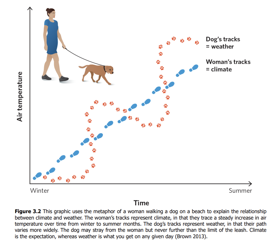
Metaphor for climate and weather (Dog & Woman on the Beach)
Woman walking in straight line: Climate (steady, predictable trend).
Dog wandering on leash: Weather (erratic, unpredictable, but constrained by climate).
Weather fluctuates daily but follows long-term climate trends.
Solar Radiation patterns
Earth = sphere, tilted at 23.4° on axis.
At equator: Sunlight hits directly, concentrated on smaller surface area → more energy per unit area.
At higher latitudes: Sunlight spreads over larger area → less energy per unit area → cooler.
Equinoxes
Sun directly over equator → equal day/night.
Solstices
Longest/shortest days
June solstice
Sun over Tropic of Cancer (23.4°N) → NH summer, SH winter.
December solstice
Sun over Tropic of Capricorn (23.4°S) → SH summer, NH winter.
Patterns of Solar Radiation by Latitude
Seasonal variation at the poles
One pole experiences near-complete darkness while the other has constant (indirect) sunlight.
Peak solar energy shifts seasonally
Moves between the Tropic of Cancer (north) and the Tropic of Capricorn (south), depending on the season.
Equator receives the most annual solar energy
Despite seasonal shifts, the equator consistently gets the largest total annual input of sunlight.
Atmospheric Circulation – 5 Key Observations
Most solar radiation at equator.
Cold air is heavier than hot air.
e.g., hot air balloons rise.
Air pressure decreases with altitude.
e.g., chip bags expand at high elevation.
Compression heats air; expansion cools air.
e.g., pump nozzle heats up, spray can cools.
Warm air holds more water than cold air.
e.g., breath condenses on cold glass.
Hadley circulation cell:
➢ It starts as warm, moist air rises at the equator due to solar radiation.
➢ As this air ascends, it expands and cools, releasing its moisture as rainfall.
➢ This dynamic produces tropical rainforests near the equator.
➢ Cold air is denser and drops back toward the Earth.
➢ As it descends, it warms.
➢ The warm, dry air can absorb water from the Earth’s surface, producing deserts at around 30° north and south latitudes.
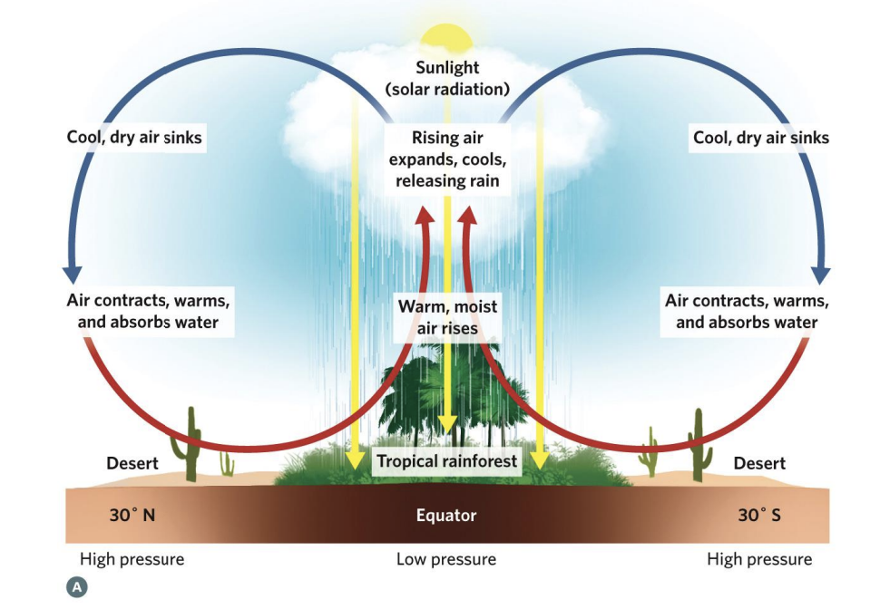
when does low pressure happen
Low pressure = happens when warm air rises. As it rises, it leaves behind less air near the surface → “low pressure.”
when does high pressur ehappen
happens when cool air sinks. As it sinks, it adds more air near the surface → “high pressure.”
Atmospheric circulation cells across the planet by latitude.
➢ Atmospheric low pressures result from rising columns of air, and high pressures result from descending columns of air.
➢ A rising column of air cannot rise without limit, so it also moves north or south, away from the equator.
➢ This movement toward higher latitudes, combined with the rise and fall of warmed and cooled air, creates interconnected cells of circulating air between the equator and the poles.
➢ This circulation pattern produces alternating high- and low-pressure zones, as well as alternating bands of relatively wet and dry habitats at fairly predictable latitudes across the Earth’s surface.
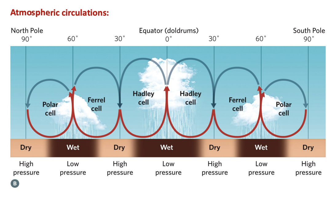
Coriolis effect
The Coriolis effect is the apparent deflection of moving objects (like wind or ocean currents) due to the Earth’s rotation.
In the Northern Hemisphere, moving air/water is deflected to the right.
In the Southern Hemisphere, it’s deflected to the left.
The effect is strongest near the poles and weakest at the equator (almost zero there).
It explains why large-scale winds (trade winds, westerlies) and ocean currents curve rather than move in straight lines.
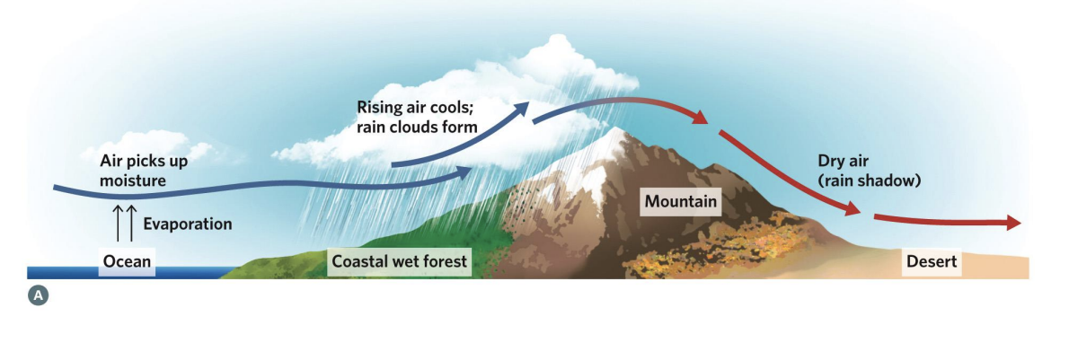
Rain Shadows
Formation of a rain shadow. As warm, moist air is forced to higher elevations over a mountain, it expands, cools, and loses its water as rain. On the back side of the mountain, air that has become cold and dry descends, warms, and absorbs water from the land surface, producing dry conditions.
Satellite view of a rain shadow formed by the Sierra Nevada mountains between California and Nevada, with ground-level photographs in inserts. Wind from the west creates moist forests and lakes on the windward side of the mountains, while the leeward east side is dry and parched.
Specific heat capacity
the amount of heat energy that must be added to one unit mass of a substance to raise its temperature by 1 °C
Water has an exceptionally high heat capacity because water molecules form hydrogen bonds among themselves, which require energy to break.
Water has five times the heat capacity of the soil.
Continental effect
for coastal areas (maritime), the ocean buffers the temperature changes and creates a moderating, stabilizing climatic effect, leading to cooler summers and warmer winters.
Locations far from large water bodies face wider temperature ranges—hotter summers, colder winters, and larger day–night temperature differences—because land heats and cools faster than oceans.
Biomes
: large geographic areas affected by similar climatic and physical factors, leading to distinctive formations of animals and plants.
Terrestrial biomes are generally determined by
climate (sunlight, temperature, water) and soil types, but they are usually characterized by the characteristics of the plant community
characteristics of the plant community
Plant growth form (trees, shrubs, grasses)
Morphology (tall, short, shrubby)
Leaf characteristics (broadleaf, needleleaf)
Plant spacing (dense forest, open woodland,
savanna).
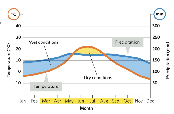
Generalized climate diagram:
The orange line indicates average monthly temperature (°C), and the blue line indicates average monthly precipitation (mm) over a year.
Months in yellow on the x-axis show when temperatures are above freezing. Shading around the curve indicates water availability for plants.
Blue shading between temperature and precipitation lines indicates likely enough rainfall for growth. Yellow shading indicates when evaporation surpasses precipitation, leading to dry conditions that may hinder plant growth.
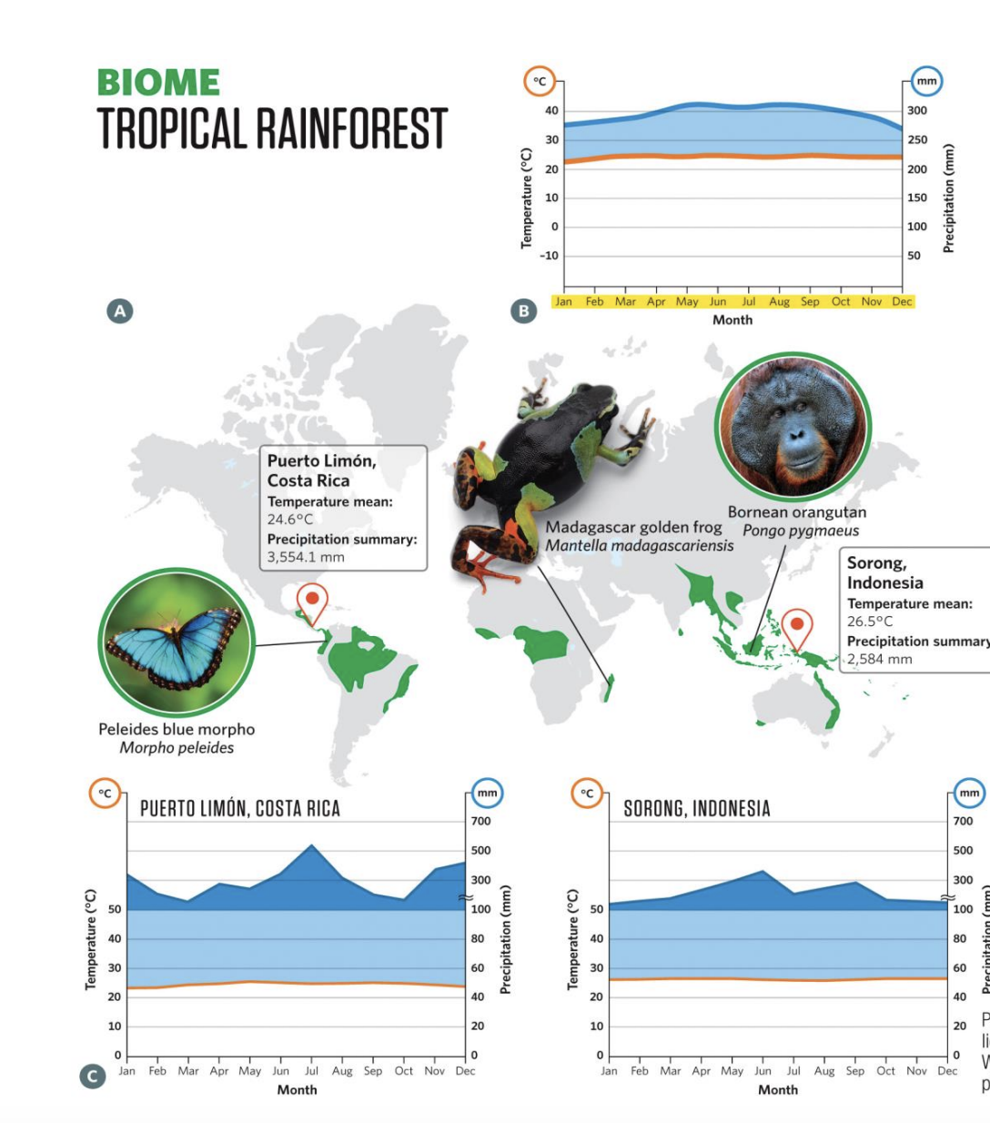
biome: tropical rainforest
Location & Climate: Found near the equator (20° N–20° S) with consistently warm temperatures (25–27 °C) and very high rainfall (>2,000 mm/year). No true seasons.
Soils & Growth: Nutrient-poor soils due to rapid uptake by dense plant life. Trees grow year-round without growth rings.
Structure: Tall evergreen canopy (30–45 m) intercepts most sunlight; below are layers of vines, epiphytes, and shade-adapted understory plants. Forest floor is dark, dominated by fungi and decomposing matter.
Biodiversity: Incredibly diverse, housing 40–75% of Earth’s species. A single hectare may contain thousands of insect species, hundreds of tree species, and many other plants.
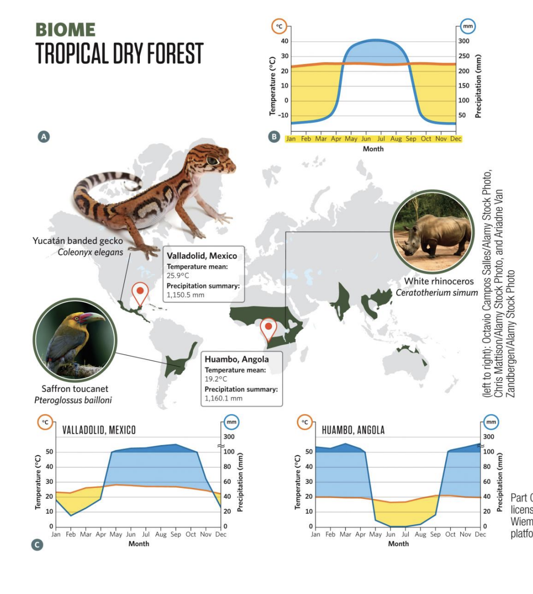
biome: tropical dry forest
Location & Climate: Found at 10°–20° latitude, warm to hot year-round (25–39 °C). Rainfall (1,300–2,800 mm) is seasonal, with a distinct wet season (3–6 months) and a pronounced dry season.
Seasons & Vegetation: Lush and green in wet season; during dry season, most trees are deciduous, dropping leaves, leaving a brown, parched landscape. Lower canopy than rainforests; understory herbs and grasses thrive when light reaches the ground.
Soils & Growth: Richer in organic matter and nutrients than tropical rainforest soils, since decomposition slows during the dry season. This allows rapid plant growth once rains return.
Biodiversity: Supports diverse animals such as coatis, iguanas, wild pigs, tigers, monkeys, and parrots.
biome: tropical savana
Location & Climate: Found at 10°–25° latitude, especially in Africa and South America. Warm year-round (24–29 °C) with a short wet season and long, hot dry season. Annual rainfall 400–1,200 mm, often arriving in intense storms.
Soils & Vegetation: Thin, nutrient-poor soils that don’t hold water well; periodic fires and drought limit tree growth. Landscape is dominated by grasses with scattered trees or shrubs.
Adaptations: Grasses regrow quickly after fires and tolerate drought; many plants are dormant in the dry season.
Biodiversity: Home to large numbers of grazing and browsing animals (springbok, elephants, giraffes) and many invertebrates (locusts, grasshoppers). Many species migrate to follow seasonal rains.

biome: desert
ocation & Climate: Found worldwide; defined by evaporation exceeding precipitation (<250 mm/year). Includes hot deserts (Sahara), cold deserts (Antarctica), and others (e.g., Sonoran, Namib). Often occur near 30° N/S or at poles.
Environment & Productivity: Very low primary productivity due to limited photosynthesis. Sparse plant cover exposes soils and geology, creating dramatic landscapes.
Vegetation: Plants like cacti and succulents are adapted to conserve water (spines, thick tissues). Vegetation is sparse and widely spaced.
Biodiversity: Animal abundance is low but includes well-adapted species (bighorn sheep, snakes, scorpions). High levels of endemic species found only in deserts.

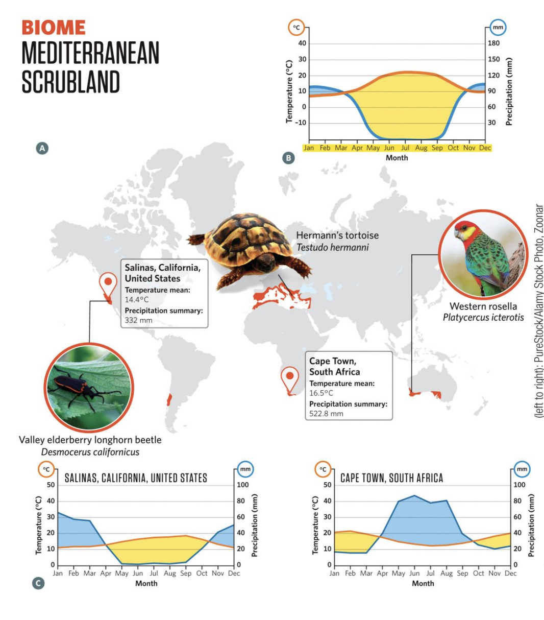
biome:mediterranean scrubland
Location & Climate: Found in 5 regions worldwide (e.g., California chaparral, South African fynbos) between 30°–45° latitude, usually on west coasts near cool ocean currents. Climate = cool, wet winters and hot, dry summers with seasonal drought.
Vegetation: Dominated by shrubs, small trees, and grasses adapted to drought. Three plant strategies: (1) winter-growing annuals/herbs, (2) deciduous shrubs/trees losing leaves in summer, (3) evergreens with deep roots and thick leaves. Fire is frequent (every 10–25 years), and many plants are fire-adapted.
Adaptations & Ecology: Plants withstand dry summers with water-saving traits; some seeds require fire to germinate. Animals include goats and sheep (broad plant diets), reptiles (active in hot summers), amphibians (thrive in cool, wet winters), and migratory birds that stop during mild winters.
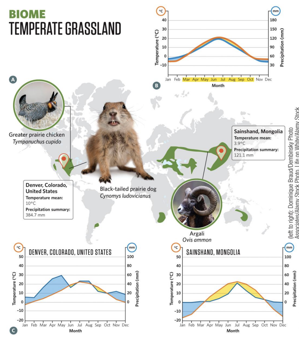
biome: temperate grassland
Location & Climate: Found at 30°–55° latitude, mainly in continental interiors. Cold winters, hot summers, and 300–1,000 mm of annual rainfall, mostly in summer. Frequent lightning and fires maintain grass dominance.
Vegetation & Soils: Dominated by annual or perennial grasses, some very tall (e.g., big bluestem, switchgrass). Annual dieback creates rich organic soils that are fertile and ideal for agriculture (“world’s breadbaskets”).
Adaptations & Ecology: Grasses regrow quickly after grazing or fire; seasonal growth peaks in spring and declines in autumn.
Biodiversity: Home to large grazing mammals (bison, antelope, pampas deer, yaks, kangaroos) and many burrowing/ground-nesting animals.
biome: temperate forest
Location: 35°–60° latitude, mainly Northern Hemisphere (E. North America, Europe, E. Asia)
Climate:
Warm, humid summers
Cold, snowy winters
Precipitation: fairly consistent year-round
Vegetation:
Dominated by deciduous trees (lose leaves in fall)
Fall: color change → chlorophyll breaks down, carotenoids/anthocyanins show
Variations:
Conifers at higher latitudes
Evergreen broad-leaved trees in warmer/wetter zones
Vertical structure: canopy → understory → shrub layer → ground layer (ferns, herbs, mosses)
Soil:
Rich in carbon + nutrients from leaf litter
Decomposition = adds fertility + biodiversity
Animals:
White-tailed deer, squirrels, cardinals, many species near human populations

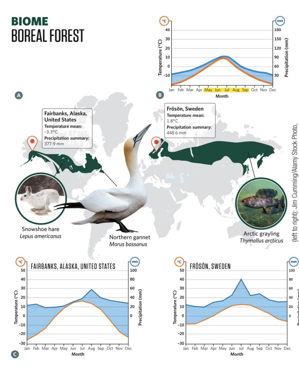
biome: boreal forest
Location: 50°–65° N latitude, mainly Northern Hemisphere (large landmass only there)
Extent: Covers ~11% of Earth’s surface, ⅓ of world’s forests
Climate:
Long, harsh winters (below freezing for 6+ months, as low as −59°C in Alaska)
Short summers (2–3 months, 10–21°C)
Precipitation: 200–600 mm/year, mostly snow
Soil:
Permafrost in higher latitudes → shallow roots, waterlogged ground
Poor drainage + slow decomposition = thick organic detritus layer
Acidic, nutrient-poor soil (from needle litter)
Vegetation:
Dominated by evergreen conifers (spruce, fir), 15–30 m tall
Dense canopy → sparse understory
Needle leaves = adapted to cold + slow decay
Animals:
Moose, wolves, snowshoe hare, lynx, loons, ptarmigan, grizzly bears
Low biodiversity (few tree species vs. tropical rainforests’ 300+/hectare)
Special Features:
Extreme seasonality (long winter, short growing season)
Wet, boggy areas from poor soil drainage
biome: tundra
Location: Above 65° N & S (Northern Hemisphere + Antarctica in the south)
Climate:
Avg. temp: −10°C to −16°C
Long, harsh winters: 8–10 months
Short growing season: 1–2 months, 20–24 hrs daylight
Precipitation: Low, mostly snow, year-round (no strong seasonality)
Soil:
Permafrost underlies region → shallow roots, waterlogged summer soil
Vegetation:
No trees (tree line boundary)
Low-growing: lichens, mosses, dwarf shrubs (e.g., willows)
Slow growth, small size (few feet tall)
Landscape:
Open, vast, wet/soggy in summer → streams, ponds, wetlands
Stunning scenery but harsh conditions
Animals/Insects:
Summer = huge swarms of biting insects (mosquitoes, blackflies, deerflies)
Wildlife adapted to cold, but biodiversity is very low
Special Features:
Extreme seasonality (dark, long winters vs. continuous daylight in summer)
Acts as boundary biome between boreal forest and polar desert

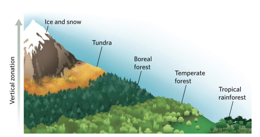
Mountain Zones
Vegetation zonation as altitude increases up a tropical mountain is similar to how vegetation changes with latitude.
Marine zones are characterized based on four metrics:
(1) proximity to the shoreline (horizontal arrows)
(2) physical location (i.e., the bottom surface [benthic] versus the water column [pelagic]);
(3) depth of the pelagic zones (shades of blue); and
(4) light penetration (vertical arrows)
![<p>(1) proximity to the shoreline (horizontal arrows) </p><p>(2) physical location (i.e., the bottom surface [benthic] versus the water column [pelagic]);</p><p> (3) depth of the pelagic zones (shades of blue); and </p><p>(4) light penetration (vertical arrows)</p>](https://knowt-user-attachments.s3.amazonaws.com/55a9ae09-b526-47d8-8d39-1eb10e82a559.png)
Estuaries:
Semi-enclosed coasts where river water mixes with seawater; highly productive.
like the Chesapeake Bay estuary, experience shifts in salinity with the tides and constitute a rare zone where marine, terrestrial, and freshwater environments interact. They are one of three marine-terrestrial interface zones where complex plants are found. Estuaries can be extremely productive environments.
Mangrove Forests:
Intertidal, salt-tolerant trees; stabilize shores and provide nursery habitat.
can serve as important zones for moderating influences between marine and terrestrial environments. They catch much of the runoff from terrestrial environments and reduce tidal surges into terrestrial environments. The mangrove trees shown here are in Belize.
Seagrass Beds:
Shallow underwater meadows of flowering plants; shelter fauna and trap sediment.
A hawksbill turtle (Eretmochelys imbricata) grazes on a seagrass bed in the Caribbean. Seagrass beds are diverse and productive systems that can harbour many species
Coral Reefs:
Warm, shallow carbonate structures built by corals; biodiversity hotspots.
Warm-water coral reefs, such as this one in Cozumel, Mexico, cover only one-tenth of a percent of the ocean, but they harbour approximately 30% of the world’s fish species.
Rocky Substrate Zones:
Bedrock/boulder shores supporting attached algae and invertebrates.
Tidal pools frequently found along the rocky-substrate zone are home to many species of marine invertebrate and fish species.
Kelp forests found along some of the world’s rocky-substrate zones create an environment that is rich in marine life.
Sandy-Bottom Zones:
Shifting nearshore sands with burrowing organisms, shaped by waves/currents.
Sandy-bottom zones are extremely dynamic as the sand greens are constantly changing position in response to wind waves and tides.
Sandy-bottom marine habitats are common. In these locations, most of the organisms, like mole crabs (Emerita sp.), live beneath the shifting sands.
Open Oceans:
Offshore sunlit pelagic waters; plankton-based food webs.
Deep Oceans:
Dark, cold waters below the photic zone; detritus/chemosynthesis sustain life
Freshwater habitats cover roughly
0.01% of Earth's surface (terrestrial 30% marine 70%) The vast majority of freshwater on the planet is locked up in glaciers and ice caps.
Freshwater systems can be categorized as
lotic
lentic
aquifer
Lotic:
Flowing freshwater—streams and rivers—with current.
Lentic:
Still freshwater—lakes and ponds—often seasonally stratified.
Aquifer:
Permeable underground layers that store and transmit groundwater
Human Effects on Global Climate and Biomes
1. Greenhouse Gases and Increasing Average Global Temperatures
2. Sea-Level Rise
3. Extreme Weather Events
4. Human Effects on Biomes
The Earth’s climate has changed several times throughout its history due to changes in
• Earth’s tilt, its position relative to the Sun,
• plate tectonics,
• volcanic activity,
• meteor impacts.
Greenhouse effect:
Warming of Earth by atmospheric absorption and re-radiation of infrared radiation emitted by Earth’s surface. This effect is due to greenhouse gases in the atmosphere, primarily water vapour (H2O), carbon dioxide (CO2 ), methane (CH4 ), and nitrous oxide (N2O).
Human Effects on Biomes
desertification due to land use change
loss of grasslands to agriculture
coral bleaching due to warming oceans and ocean acidification
estuaries affected by pollution and sea level rise
deforestation, habitat loss for species
soil degradation loss of land fertility