Geography Distinctive Landscapes (+ Costa Rica case study from sustaining ecosystems)
1/118
Name | Mastery | Learn | Test | Matching | Spaced | Call with Kai | Chat |
|---|
No analytics yet
Send a link to your students to track their progress
119 Terms
How much of the world’s biodiversity does costa rica contain
6%
how many tourists does costa rica attract
over 2 mil per year
Costa rica location
small country in central america
When did costa rica begin to experience rapid deforestation & why was this
1960s
it was due to cattle ranching and agricultural development
how much forest was deforested at the highest point in costa rica
32k hectares a year
What did the government of costa rica do to combat deforestation
established protected areas of forest throughout the country
passed laws to stop deforestation
paid landowners to keep land as forest rather than cutting it down (financial incentive)
how much of costa rica’s land is protected today
24%
agroforestry
trees and crops are grown together, so that crops benefit from shelter of the canopy, trees prevent soil erosion, and crops benefit from nutrients in leaf litter
selective logging
trees are only felled when they reach a certain height - young trees ensure that the height of the canopy is maintained
afforestation
trees are planted to replace those cut down (but it lacks biodiversity as species have to re-establish)
monitoring
sattelites & photos ensure that no illegal activites are taking place in forests
ecotourism
a type of sustainable development that aims to create local employment while conserving the natural environment
doesn’t damage natural environment
relatively small scale
consults with local community about developments
infrastructure improvements benefit local people too
example of an ecotourism resort w/ psd x 4
monteverde cloud forest
10,000-hectare wildlife reserve
3,000 plant species
400 bird species
100 mammal species
how does Monteverde protect the environment
controlled tourist access with unpaved roads only accessible with 4×4s
info & guidlines for tourists on minimising environmental impact e.g. specific trails, respecting wildlife, limiting noise, no flash photography
school that works with monteverde resort
santa elena high school
integrates monteverde ecology into curriculum
promotes conservation
promotes skills for ecotourism jobs
school-run santa elena reserve helps disperse tourist crowds
sucesses of monteverde resort
attracts 250k tourists each year with minimal environmental impact
benefits the economy
harmonious coexistence between humans and wildlife
challenges of monteverde resort
increasing tourists = more facilities = less forest/land
inevitably some environmental damage occurs
landscape
an area of land with a particular appearance
it can be any scale, and may be physical, human, or a combination of both
relief
the way the landscape changes in height
uplands
areas that are high above sea level and often mountainous
lowlands
areas that are not very high above sea level and often flat and rolling
examples of natural / physical elements of landscapes
mountains
coastlines
valleys
plains
rivers
lakes
soils
geology
examples of biological elements of landscapes
vegetation
marshes
wildlife
habitats
plants
examples of human elements of landscapes
anything made by humans
infrastructure
communications
industry
farmlands
paths
examples of variable elements of landscapes
temporary things / things that change
weather
smells
sounds
season
glaciated upland areas
upland areas formed through glaciation, where glaciers erode the surface of the land
non glaciated upland areas
upland areas formed through river erosion and weathering (often made of limestone / sandstone)
sometimes found in areas also formed through glaciation
glaciated lowland areas
glaciers have created fertile plains and rolling landscapes, providing an opportunity for settlements and farming
non glaciated lowland areas
areas of flat land formed by deposition, often marshy and found near the coast
characteristics of glaciated landscapes
u-shaped valleys
rolling, fertile plains
steep mountain peaks
ridges
human activities in glaciated landscapes
farming in the fertile land created
building settlements in the rolling plains
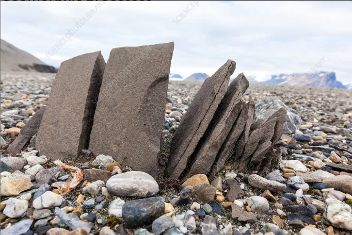
igneous rock
formed from molten rock at depth or that reaches the surface as lava
granite, basalt
sedimentary rock
formed from sediments carried by rivers to the sea and deposited in layers called beds
clay, sandstone, limestone
metamorphic rock
rock that is changed by heat and/or pressure when mountains are formed as tectonic plates collide
slate, schist, marble
mechanical weathering
aka freeze-thaw weathering
caused by large temp changes between night and day
rainwater collects in cracks in rocks, water freezes into ice and expands, repeated freezing and thawing makes the crack bigger, crack widens enough for the rock to split apart
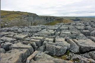
chemical weathering
can happen with acidic rain - rain dissolves carbon dioxide in the air, making rainwater acidic. when it falls it causes chemical weathering
limestone and chalk are more easily effected
can form limestone pavements (see image)
biological weathering
caused by plants and animals e.g:
tree roots force into rocks, splitting them apart
small plants (e.g. moss) grows on the surface of rock, making it crumble
animals burrow into softer rocks
animals can trample with their feet
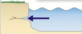
erosion: hydraulic action
waves crash against the coast, forcing air into cracks and breaking up rock
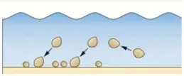
erosion: attrition
pebbles are picked up by waves and bash into each other, wearing down into smaller, rounder pieces
erosion: abrasion
waves pick up rocks from the seabed and smash them against the coast, wearing it away
erosion: solution
some rocks like limestone slowly dissolve in water
transportation: traction
boulders and large stones are dragged along the river/sea bed
transportation: saltation
pebbles and small stones are picked up and dropped further along
transportation: suspension
tiny particles of sand and silt are carried in the water
transportation: solution
some rocks dissolve and are carried by the water, invisible to the naked eye
deposition
the dropping of material on land when the water no longer has enough energy to carry it
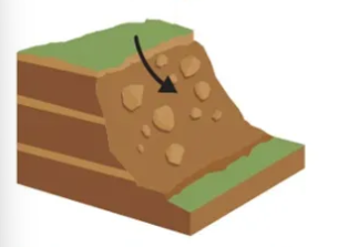
mass movement: sliding
sudden movement of large volumes of rock/soil along a zone of saturated soil
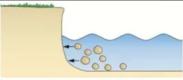
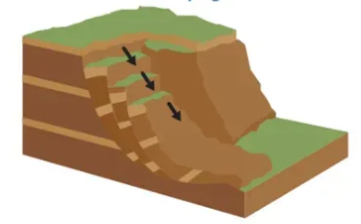
mass movement: slumping
rapid mass movement of permeable rock & soil (e.g. clay) that has become heavily saturated, lying on top of impermeable material
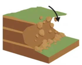
mass movement: rock falls
free-fall movement of rock fragments due to gravity. increased by mechanical weathering
coast definition
a narrow zone where the land and sea overlap and directly interact
its development is affected by the interaction of physical and human pocesses
beaches
the main depositional landform found at the coast
material has built up between high and low mark. beach material can be brought from the swash of waves, landslides on cliffs, and rivers transporting sediment to estuaries
swash (of a wave)
the water washed up the beach
backwash (of waves)
the water that runs back down the beach
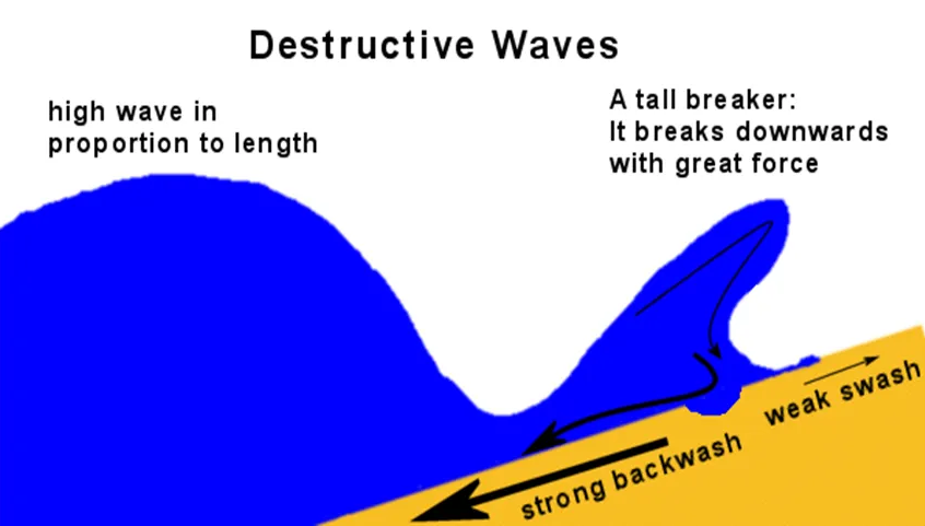
destructive waves
waves that erode the beach
high wave in proportion to length
tall breaker that breaks downwards with great force
strong backwash
weak swash
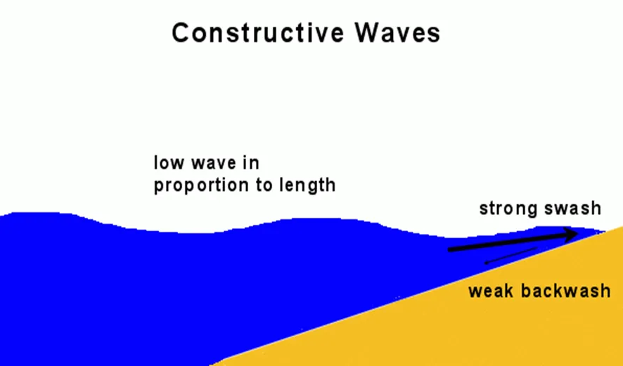
constructive waves
waves that deposit sediment and create beaches
low wave in proportion to length
strong swash
weak backwash
deposits sediment due to its strong swash, and doesn’t have enough backwash to take it away
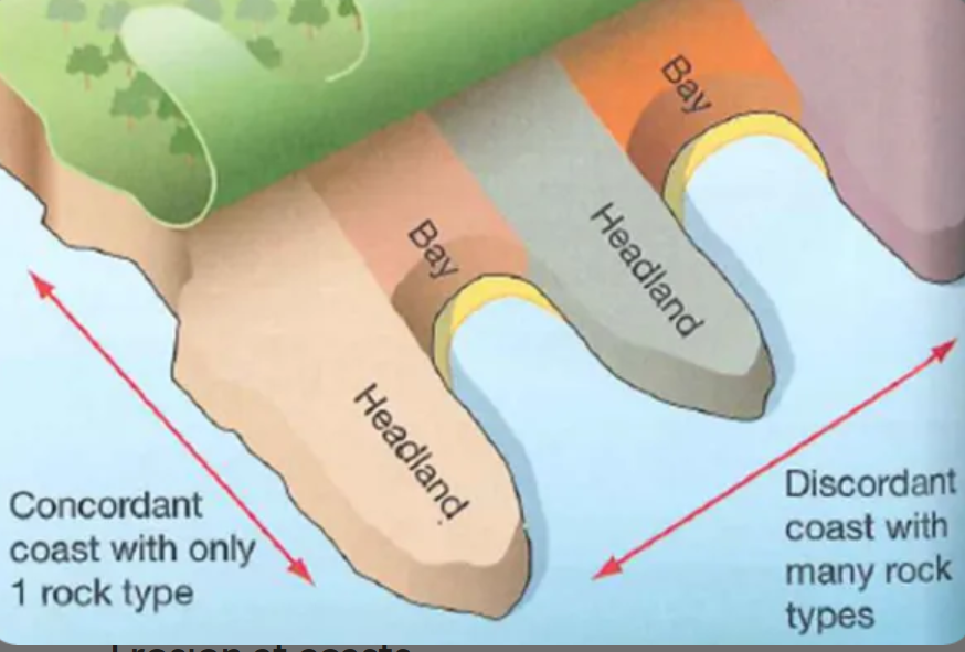
headland
a hard piece of rock that sticks out into the sea
bay
an area of coastline which has receded backwards, usually with beaches
concordant coastlines
has the same type of rock along its length, creates fewer bays and headlands
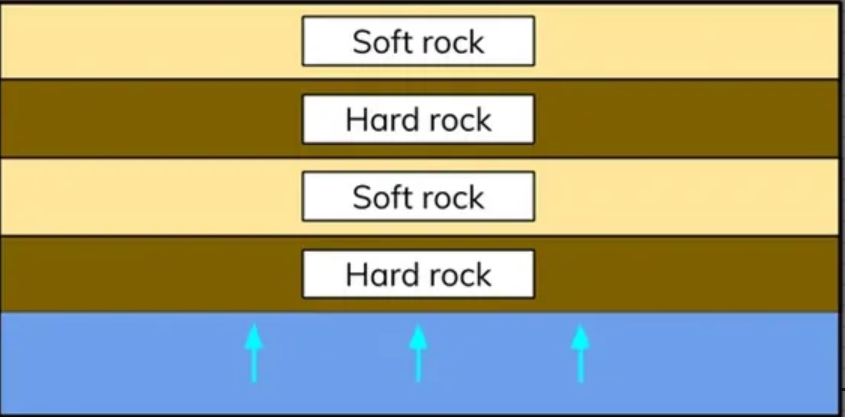
discordant coastlines
bands of rock type run perpendicular to the coast
differing erosion speeds between softer & harder rock leads to the formation of headlands & bays
formation of cracks, caves, arches, stacks & stumps
crack is opened by hydraulic action
crack eroded & grows into a cave
cave is eroded until water breaks through the back to form an arch
after more erosion the unsupported top of the arch collapses, forming a stack
stack is eroded around the base and falls, forming a stump
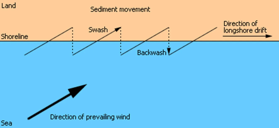
longshore drift
the movement of beach material by the sea along the coast
direction is determined by the direction of the prevailing wind
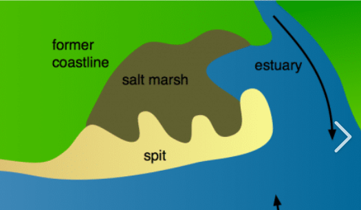
spits
an extended stretch of beach that projects out to the sea and is joined to the mainland on one end
ususally found at the mouth of a river
over time can develop a hook if the wind direction changes further out
waves can’t get past it, forming a sheltered area where silt is deposited - salt marshes
hard engineering
using man-made structures to stop waves in their tracks
more expensive but more effective
used in front of high-value land
soft engineering
smaller, more natural structures to reduce energy in waves to protect in a more natural way
less expensive but less effective
sea walls
hard engineering
walls of concrete placed at the foot of cliffs / top of beach to prevent erosion
good at protecting valuable land but expensive (up to £5k per meter)
groynes
hard engineering
wooden fences running at right angles to the beach & go out to sea to interrupt longshore drift by trapping sediment. also absorb wave energy, reducing erosion
result in a larger beach but are expensive (up £10k each) & can starve other beaches of sediment
rock armour / rip-rap
hard engineering
dumping large boulders of rock at the base of a cliff / sea wall that help the wave break & absorb its energy
relatively cheap (£300 / meter) & can look more natural but can be hard to transport & make accessing the beach harder
offshore reefs
soft engineering
sandbanks built parallel to the coast out to sea that force the waves to break before they reach the shore
don’t spoil the look of the beach but are very expensive (£1.3mil each) & hard to maintain
beach nourishment
soft engineering
adding additional beach material to the beach to make it higher & wider
cheap (£3k / km) & blends with the beach but needs constant replacement & doesn’t stop waves
managed retreat
soft engineering
controlled flooding of low-lying, low-value areas to take away risk of damage to other areas
cheaper compared to other defences but land is lost & landowners need to be compensated
chesil beach in jurrasic coast
18 miles long
from west bay to isle of portland
can get up to 15m high and 200m wide
pebbles of flint & chert
mudeford spit in jurrasic coast
lots of longshore drift (south → southwest winds)
beach recharge used because no erosion from beaches further up so no sediment
made of boscombe sands
temp of jurrasic coast
warm, dry summers (21’)
mild, wet winters (min 3’)
freeze-thaw weathering is rare
salt weathering is prominent
wind in jurrasic coast
southwest winds can bring storms from the atlanctic
winds bring high energy destructive waves that increase erosion
unstable cliffs mean mass movement
rainfall in jurrasic coast
relatively low rainfall but can be heavy during storms
soil saturates, causing slumping
chemical weathering of chalk cliffs
geology of jurrasic coast & geomorphic processes
both concordant and discordant coastlines
headlands
rock is vulnerable to solution
human activity in jurrasic coast
quarrying: limestone quarried on isle of portland, exposing rock & making them vulnrable to chemical erosion
tourism: tourists erode footpaths & trample vegitation, exposing underlying soil to weathering & erosion
management strategies: costal defences change the natural landscape & alter costal processes
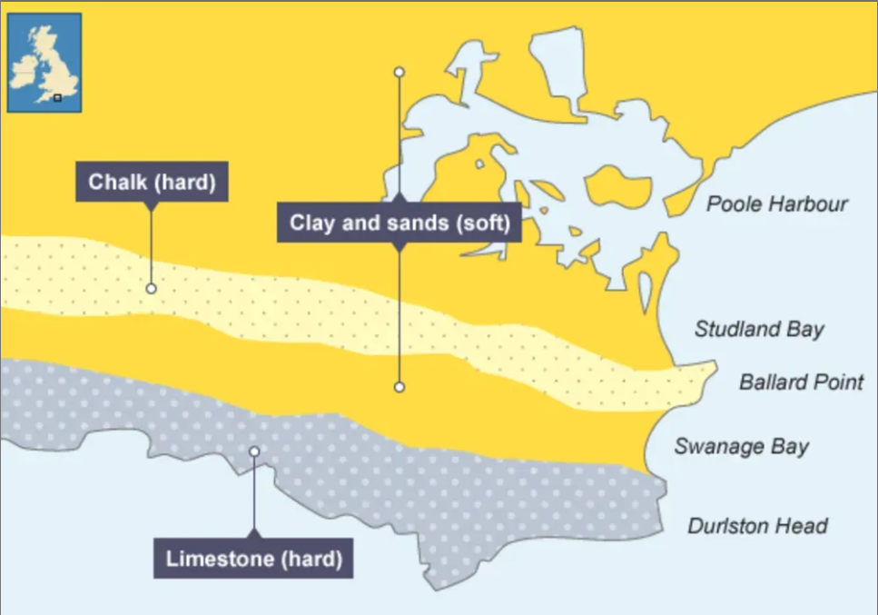
headlands & bays in jurrasic coast
the area around swanage is made up of bands of harder rock (chalk & limestone) & softer rock (clay & sands)
studland & swanage bays
durston head & ballard point (headlands)
old harry rocks in jurrasic coast location
2 miles northeast of swanage & 1 mile east of studland, on the eastern edge of the isle of purbeck
impact of climage change on jurrasic coast
warming temps = higher sea levels: sea around uk expected to rise by 600mm by 2100
warmer atmosphere = more likely intense storms = more powerful waves = more erosion
more intense rainfall = greater weathering of cliffs & more mass movement & rockfalls
jurrasic coast: hold the line
shoreline management plan based around swanage
aims to protect swanage from erosion & improve features for residents & visitors
plan is to build 19 groynes to replace 75yo ones & replenish beach with 160k tons of sand
sea walls in jurrasic coast
some put in place in south in swanage in late 1800s & extension added in 1920s
beah reacharge in jurrasic coast
90,000m³ of sand deposited in 2005
now the beach will need to be recharged with around 40,000m³ every 20 years
groynes in jurrasic coast
some put in south of swanage in late 1800s & more added in 1920s
scheme extended in 1960s as it starved other beaches of sediment
groynes replaced in 2005
upper course of rivers
common features: waterfalls, v-shaped valleys, steep relief
source found in mountains, starting off tiny but tributaries feed into it & increase the size
vertical erosion takes place, creating a V-shaped side profile as the river erodes downwards
middle course of rivers
common features: meanders, oxbow lakes, flat land, floodplains
both erosion & deposition take place
side profile is less steep as lateral erosion starts taking place
lower course of rivers
common features: very wide river, river mouth / estuary, industry on banks, marshy flat land, floodplains
deposition & lateral erosion
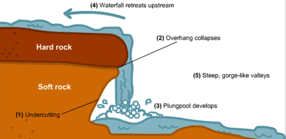
waterfalls
forms when more resistant rock lies on top of less resistant rock
water erodes less resistant rock (hydraulic action & abrasion) forming an undercut & plunge pool
more resistant rock on top doesn’t erode, forming an overhang
eventually unsupported overhang collapses into plunge pool
process repeated & waterfall retreats upstream to form a gorge
waterfalls form because of differential erosion
v-shaped valleys
river vertically erodes straight down
steep sides of river weaken (due to precipitation & weathering)
eventually sides break & fall into river channel, creating a v-shape
interlocking spurs
ridges of rock extending alternately, with a stream/river running between
formed because of river winding & bending to find the areas of least resistance. non-resistant rock erodes more quickly, creating uneven appearance
meanders
bends in a river formed because of river curving because of naturally uneven land
water moves fastest on the outside of the bend & slowest on the inside
where it moves fastest on the outside it erodes, forming river cliffs
where it moves slowest on the inside it deposits, forming a slip-off slope
meanders become larger over time
oxbow lakes
still, curved bodies of water near a river
formed through meanders changing shape over time so that the ends of the beds end up joining. the water takes the easiest route, cutting off the bend.
floodplains
the areas of land on either side of a river that are covered in water when the river floods
very fertile because of the minerals deposited when the river floods
alluvium: the fine sediment & minerals deposited on the floodplain when the river floods
often used for farming because of the fertile soil
levees
extended banks of deposited material on the sides of rivers
when the river floods, sediment is deposited across the floodplain with the largest material being deposited first, closest to the river. after many floods this builds up
flooding definition
when a river overflows its banks onto the surrounding land
discharge
the amount of water in a river
river drainage basin
the area of land surrounding a river
surface run-off
water that runs over the surface of the ground towards a river
infiltration
when rainfall moves down into the ground
causes of flooding
physical:
weather (rainfall, surface run-off)
soil (surface run-off if soil is full of water)
geology (impermeable rocks = surface run-off)
relief (fast travel on steep relief)
drainage basins (circular = more risk as all water takes the same time to reach the river)
human:
urbanisation (impermeable ground surfaces, sloped roofs, drains)
deforestation (trees intercept water so no trees = more water)
river mismanagement (e.g. river straightening can increase flood risk downstream)