r&b: beach processes and coastal environment
5.0(1)
5.0(1)
Card Sorting
1/102
Earn XP
Description and Tags
Last updated 5:01 AM on 12/5/22
Name | Mastery | Learn | Test | Matching | Spaced | Call with Kai |
|---|
No analytics yet
Send a link to your students to track their progress
103 Terms
1
New cards
beach
land that extends from mean lower low water to dunes/bluffs/cliffs
2
New cards
shoreline
where the land and ocean meet
3
New cards
spit
linear extension of land; forms from an accumulation of sediment and is maintained by tides
4
New cards
barrier
a spit or island seaward from land; usually is parallel to land
5
New cards
bars/troughs
seabed features in surf zone
6
New cards
berm
relatively flat region of beach behind shoreline
7
New cards
foreshore
seaward sloping; area seaward of berm
8
New cards
backshore
berm and dunes
9
New cards
flood-tide delta/washover delta
features formed when beach sediment is transported landward due to tides/storms respectively
10
New cards
longshore drift/transport
movement of water and sediment parallel to beach
11
New cards
MSL
mean sea level
12
New cards
winter berms
higher up a beach relative to summer berms due to more active tides and storms
13
New cards
summer berms
lower down a beach relative to winter berms due to calmer tides and less storms
14
New cards
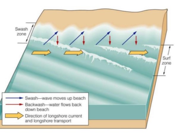
swash
upward movement of waves when they break
15
New cards
why is swash more capable of moving sediment than backwash?
some of the water goes into pore spaces rather than returning to ocean
16
New cards
backwash
downward movement of water after waves have broken
17
New cards
what is the single most important physical process on beaches?
surface waves
18
New cards
what snuffs out surface waves?
gravity
19
New cards
what propagates surface waves?
wind stress
20
New cards
wavelength
the distance from the crest of one wave to another (or other analogous point)
21
New cards
wave height
distance between the trough and crest of a wave
22
New cards
still water level
mean between trough and crest heights; approximately where water would sit if it wasn't disturbed
23
New cards
crest
the highest point of a wave
24
New cards
trough
the lowest point of a wave
25
New cards
how does water move in waves?
in an orbital fashion
26
New cards
wave period
amount of time it takes for two adjacent wave crests to cross the same point; proportional to wave length
27
New cards
in deep water, wave speed increases with...
wavelength and period
28
New cards
as waves move away from the source, they...
sort themselves out; larger waves move ahead of smaller waves
29
New cards
swell
waves with large wavelengths that reach beaches first
30
New cards
the energy of a wave is proportional to
the wave height
31
New cards
as you move down to wave base, sediment transport capacity...
lowers
32
New cards
as waves move across sea, they become...
muted due to gravity
33
New cards
once a wave forms, it will keep going until...
it breaks on a beach
34
New cards
fetch
distance a wind blows
35
New cards
bigger waves are the result of
strong winds, longer duration of winds, bigger fetches
36
New cards
sea condition waves
very jumbled structure (not organized with swell ahead of smaller waves); confused waves
37
New cards
post-generation wave conditions
waves are now organized; single wave shape characteristic
38
New cards
surf
where waves break on shore; pointed wave crest characteristic
39
New cards
in deeper water, how do things move in waves?
in a more circular orbit; influence decreases with depth
40
New cards
wave base
1/2 wavelength
41
New cards
in shallow water, how do things move in waves?
in a more elliptical orbit; as you go deeper, orbit gets thinner until it's just moving back and forth in a line
42
New cards
transition zone
occurs when waves are 10-50 m of shore (wherever water depth is less than or equal to 1/2 of wave base)
43
New cards
what happens to the seabed at the transition zone?
gets eroded; mud in suspension, sand as bedload
44
New cards
as depth decreases, what happens to wave speed and wavelength?
decreases as well (due to friction of bed); leads to wave refraction (change in wave direction)
45
New cards
as depth decreases, what happens to wave height?
increases; crest increases until height-length ratio is greater than 1/7, in which case wave breaks
46
New cards
what determines break shape of a wave?
gradient of seabed and grain size
47
New cards
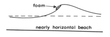
spilling breakers
occur at nearly horizontal beaches with fine sediment

48
New cards
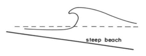
plunging breakers
occur at steeper beaches with sandier sediment

49
New cards
surging breakers
occur at steepest beaches with biggest grain sizes

50
New cards
water infiltration
when water seeps into permeable beach sediment; again, this reduces sediment transport capacity of backwash
51
New cards
how does water infiltration affect beach gradient?
coarser sediments have more pore spaces between them allowing more water to seep in; thus further reduces backwash's transport capacity; thus bigger ratio between landward and seaward transportation (landward is much bigger); thus beaches that have coarse grain sizes are steeper; this also contributes to formation of berms
52
New cards
what controls berm elevation?
wave energy and tidal range
53
New cards
rip currents (riptides)
method for water to return to sea after breaking on beach; moves in parallel direction to longshore transport until washing out to rip head (location of this depends on gradient and wave morphology)
54
New cards
undertow
a weak, non-dangerous riptide
55
New cards
wave refraction
bending of the wave crest
56
New cards
swash can move up at an angle due to refraction. what about backwash?
no, it stays perpendicular because it is driven by gravity
57
New cards
wave ray
imaginary line that moves perpendicular to wave crest to allow us to see movement of energy
58
New cards
when waves approach a straight shoreline, what happens?
wave refraction due to lowering of speed
59
New cards
when waves approach an irregular shoreline, what happens?
shallow water of headlands gets hit with most energy, backlands not hit with as much energy; leads to erosion of headlands and sediment deposition at backlands
60
New cards
what causes longshore transport?
wave refraction of swash (angled) and perpendicular direction of backwash

61
New cards
summer beach characteristics
tall dunes and wide berm
62
New cards
winter beach characteristics
dune and berm erosion, washover, and offshore bar/higher berm formation
63
New cards
to put it simply, the beach grows seaward when?
in the summer
64
New cards
to put it simply, the beach recedes landward when?
in the winter
65
New cards
storm surge
occurs in winter; when strong wind and waves push against shore with high energy, eroding it
66
New cards
what happens to the sediment eroded during storm surge?
builds offshore bars/winter berms; washes through dunes during washover and forms washover deposits
67
New cards
what happens to the sediment stored offshore during the summer?
gets pushed back back up to shore; forms summer berm
68
New cards
longshore bar
deposit of sediment just off the shore that has been eroded during storm surge
69
New cards
why are spits and barrier islands common on trailing edge margins?
gentle gradients and little tectonic uplift/subsidence
70
New cards
can spits/barrier islands appear on collision margins?
yes, only if the sediment load is abundant
71
New cards
where are these coastal barriers migrating today?
landward due to sea level rise (however, some places see seaward migration due to being right next to river mouths)
72
New cards
how do spits form?
longshore transport; inlets maintained by tides
73
New cards
barrier island characteristics
tidal inlets are both ends; elevation depends on wind/sand supply
74
New cards
what determines length of barrier islands?
tidal prism (vertical amount of water flowing in and out during tides)
75
New cards
large prism
short barrier island
76
New cards
small prism
long barrier island
77
New cards
can barrier islands be covered by washover?
yes, if they are low enough
78
New cards
two kinds of coastal barriers
spits and barrier islands
79
New cards
what are the three ways a barrier island forms?
spit elongation, bar submergence, and bar emergence
80
New cards
how are spits built?
built from tip out seaward
81
New cards
spit elongation
when a spit becomes too long for water to efficiently transport across it, an new inlet will form, making the spit a barrier island
82
New cards
bar submergence
when an old dune or other topographic high is surrounded by water as sea-level rises
83
New cards
bar emergence
when a longshore bar is formed and then rises out of sea when storm surge subsides
84
New cards
what is the time interval for tide fluctuations?
24 hours, 50 minutes
85
New cards
diurnal tide
one high and one low each day
86
New cards
semidiurnal tide
two nearly-equal highs and two nearly-equal lows each day (most common type of tide)
87
New cards
mixed semidiurnal tide
two unequal highs and two unequal lows each day
88
New cards
when are currents strongest in regards to tides?
during period of greatest water level change
89
New cards
slack water
period of least movement of water; occurs during max high and max low
90
New cards
what are the two causes of tides?
gravitational attraction of the sun and moon and centrifugal force around earth
91
New cards
tidal range
the vertical difference between max high and max low during SRPING TIDE; can be cm or m
92
New cards
ebb tide
when water level falls
93
New cards
flood tide
when water level rises
94
New cards
how often do the sun and moon cycle to affect the tides?
every 28 days or so
95
New cards
spring tides
larger tidal range
96
New cards
neap tides
smaller tidal range
97
New cards
every 28 days, how many neap and spring tides are there?
2 neap tides and 2 spring tides
98
New cards
when do neap tides occur?
during first quarter and third quarter moons (moon and sun are working against each other)
99
New cards
when do spring tides occur?
during new and full moons (moon and sun work together)
100
New cards
can local geometry differences influence tidal range?
yes; can increase or decrease depending on how much flow the seabed allows