Unit 6 Urbanization APHUG
1/36
Earn XP
Description and Tags
Name | Mastery | Learn | Test | Matching | Spaced | Call with Kai |
|---|
No analytics yet
Send a link to your students to track their progress
37 Terms
Consumer Services
Consumer services are those services that primarily meet the needs and wants of individual consumers rather than businesses. These services are typically provided directly to the consumer
Examples: Retail, healthcare, education, entertainment, restaurants, personal services (hair salons, spas, etc.).
Significance: Consumer services are essential for the functioning of urban and rural areas, as they cater to the everyday needs and preferences of individuals. They are vital for quality of life and play a significant role in the economy.
Business Services
Business services are services that primarily cater to the needs of other businesses rather than individual consumers. They facilitate the operations and functions of businesses.
Examples: Financial services (banking, insurance), professional services (legal, accounting, consulting), advertising, telecommunications, information technology (IT) services.
Significance: Business services are crucial for economic development and growth. They support businesses in their operations, decision-making processes, and efficiency, thus contributing to the overall productivity of an economy.
Public Services
Public services are services provided by government agencies or entities for the benefit of the general public. These services are often funded through taxes.
Examples: Education, healthcare, public transportation, sanitation, law enforcement, firefighting, public utilities (water supply, electricity, gas).
Significance: Public services play a critical role in societal well-being and infrastructure development. They ensure access to essential services for all citizens and contribute to social equity and cohesion.
Clustered Rural Settlement
Clustered rural settlements are settlements where buildings and houses are closely grouped together, often forming small villages or hamlets. This type of settlement pattern encourages social interaction and facilitates the sharing of resources.
Example: Villages in many parts of the world, such as rural areas of Europe, where houses are built close to each other, often around a central square or road.
Significance: Clustered rural settlements promote community cohesion, resource sharing, and efficient land use. They often have a strong sense of community and may facilitate the provision of certain services more efficiently.
Dispersed Rural Settlement
Dispersed rural settlements are settlements where buildings and houses are spread out over a wide area, with significant distances between them. This type of settlement pattern is characteristic of areas with extensive agricultural land.
Example: Farmsteads or ranches in rural areas of North America, where houses are situated far apart from each other, often surrounded by fields or pastures.
Significance: Dispersed rural settlements are typical in agricultural regions where land is used for farming or ranching. They offer privacy and space but may present challenges in terms of service provision and community interaction.
Economic Base
The economic base refers to the primary industry or industries in a region that generate income from outside the area. It comprises the basic activities that bring money into the local economy.
Example: A city with a strong manufacturing sector that exports goods to other regions or countries, thereby bringing money into the local economy.
Significance: The economic base is crucial for understanding regional economies and their resilience. It influences employment opportunities, income levels, and overall economic stability.
Enclosure Movement
The enclosure movement refers to the historical process in Europe, particularly in England, where common lands were privatized and enclosed for individual or exclusive use, primarily for agricultural purposes.
Example: Enclosure acts in England during the 18th and 19th centuries, where common lands were fenced off and redistributed among private landowners, leading to the displacement of rural communities and changes in land ownership patterns.
Significance: The enclosure movement transformed the landscape, economy, and social structure of rural areas. It contributed to the rise of large-scale agriculture, increased productivity, and the emergence of capitalist land tenure systems.
Urbanization
Urbanization refers to the process by which an increasing proportion of a population resides in urban areas, leading to the growth and expansion of cities.
Example: The migration of people from rural villages to cities in search of better employment opportunities and improved living standards.
Significance: Urbanization has significant social, economic, and environmental implications. It affects infrastructure development, land use patterns, employment trends, and resource consumption.
Market Area / Hinterland
The market area, also known as the hinterland, refers to the geographic area surrounding a central place, such as a city or town, from which people are drawn to obtain goods and services.
Example: The catchment area of a shopping mall, which includes surrounding neighborhoods and suburbs where residents typically shop at that mall.
Significance: Understanding the market area or hinterland is crucial for businesses and urban planners to assess consumer demand, competition, and market potential. It influences decisions related to retail location, transportation networks, and service provision.
Rank-Size Rule
The rank-size rule is a statistical pattern observed in urban hierarchies, where the population of a city or town is inversely proportional to its rank in the hierarchy. In other words, the second-largest city is typically half the size of the largest, the third-largest is a third the size, and so on.
Example: In a country adhering to the rank-size rule, if the largest city has a population of 10 million, the second-largest city would have a population of around 5 million, the third-largest around 3.3 million, and so forth.
Significance: The rank-size rule provides insights into the distribution of urban populations within a country or region. It helps urban planners and policymakers understand urban hierarchies, economies of scale, and the distribution of resources and services.
Primate City (Rule)
A primate city is the largest city in a country or region, significantly larger and more economically dominant than any other city in the area. The primate city often overshadows all other urban centers in terms of population, economic activity, and political influence.
Example: Mexico City in Mexico, Bangkok in Thailand, and Paris in France are examples of primate cities within their respective countries.
Significance: The primate city phenomenon highlights disparities in urban development and can have significant implications for economic and political centralization, regional development, and social inequalities within a country
Basic and Non-basic Businesses
Basic businesses are those that produce goods or services primarily for export or sale outside the local area, bringing in money from external sources. Non-basic businesses, on the other hand, cater to local needs and primarily serve the local population.
Example: A factory that produces automobiles for export would be considered a basic business, while a local grocery store serving the community would be a non-basic business.
Significance: Understanding the distinction between basic and non-basic businesses is essential for analyzing local economies.
Centralized Business District (CBD)
The central area of a city where retail and office activities are concentrated. It's typically characterized by high land values, tall buildings, and dense transportation networks.
Example: Manhattan in New York City, USA.
Significance: CBDs are crucial to understanding urban geography as they represent the economic and commercial heart of a city.

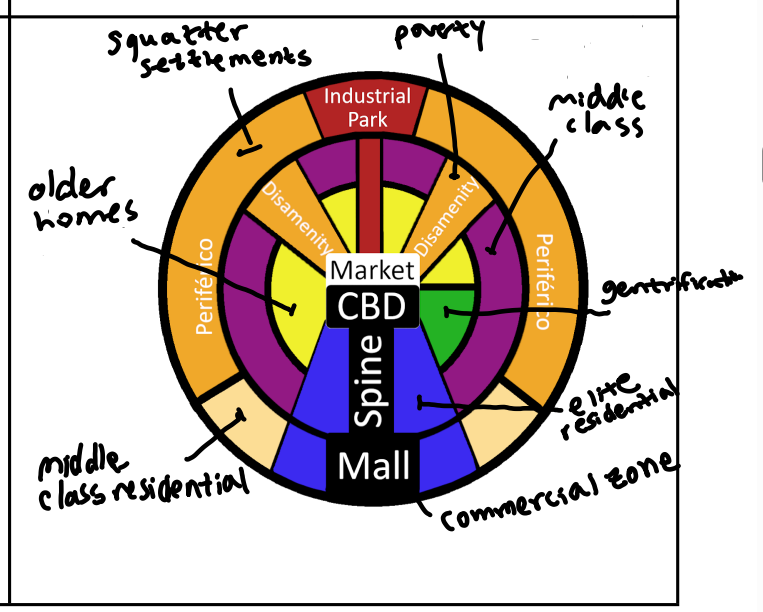
Latin American Model
A model of urban land use in Latin American cities where the elite and wealthy live in sectors radiating outward from the central business district.
Example: São Paulo, Brazil.
Significance: It reflects the social and economic disparities within Latin American cities and influences urban development policies.
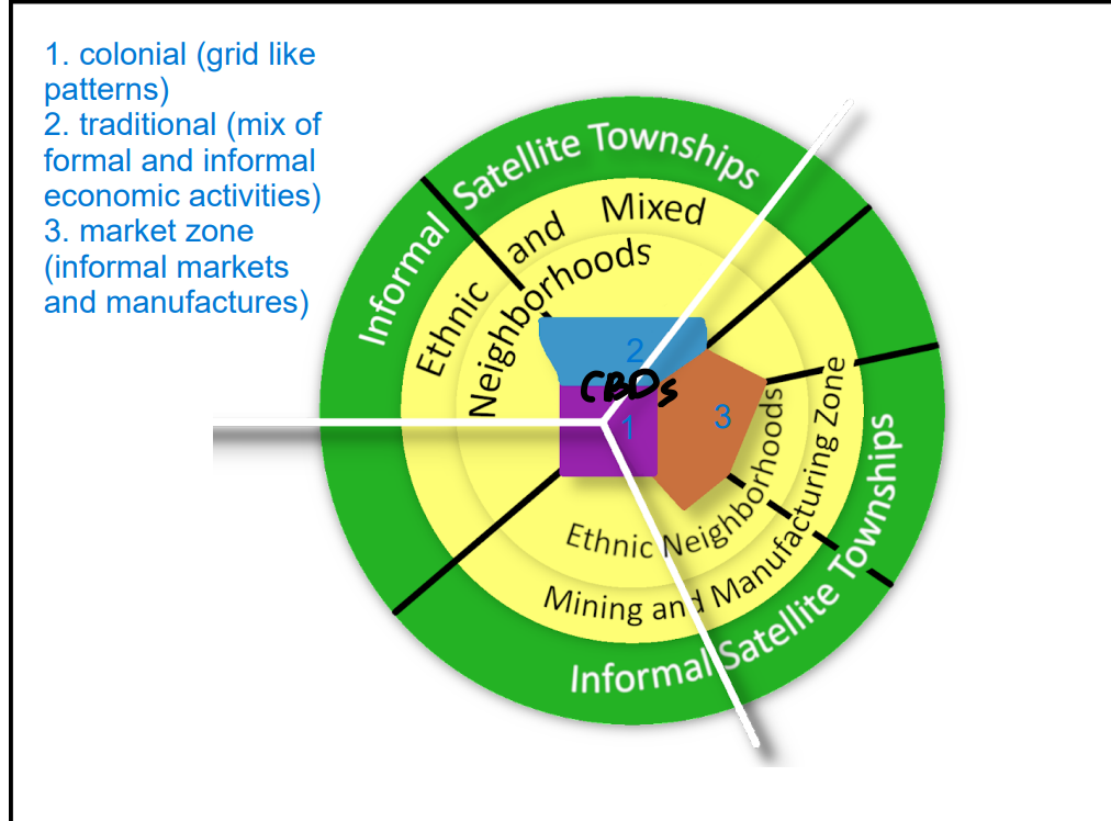
Sub-Saharan African Model
The region of Africa located south of the Sahara Desert, characterized by diverse cultures, economies, and geographical features.
Example: Nigeria, South Africa, Kenya.
Significance: Understanding Sub-Saharan Africa is important in AP Human Geography due to its unique demographic, cultural, and economic challenges, especially regarding urbanization and development.
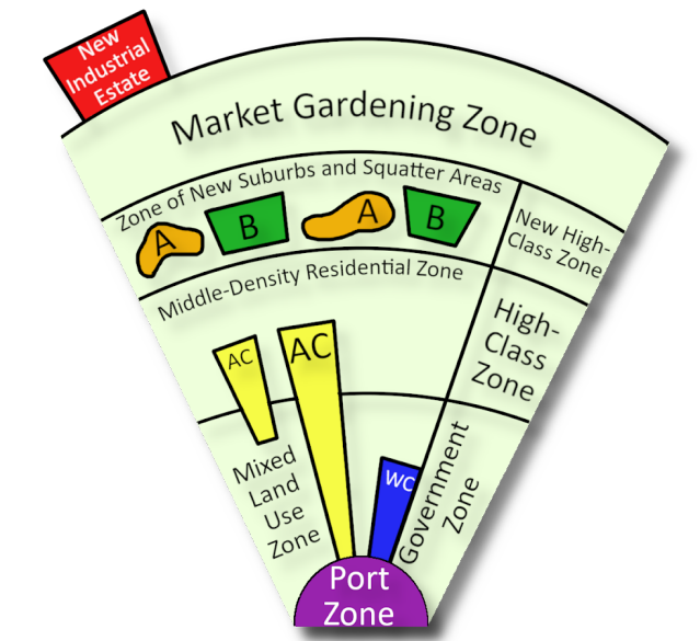
Southeast Asian Model
The region of Asia that includes countries such as Thailand, Vietnam, Indonesia, and the Philippines.
Example: Bangkok, Thailand; Jakarta, Indonesia.
Significance: Southeast Asia's urbanization patterns, cultural diversity, and economic development are significant topics in AP Human Geography due to the region's rapid growth and urbanization.
Galactic (Peripheral) model
A model of urban development where activities are spread out in a radial pattern from the city center.
Example: Los Angeles, USA.
Significance: This model illustrates the decentralization and suburbanization tendencies of modern cities, impacting transportation, land use, and social dynamics.

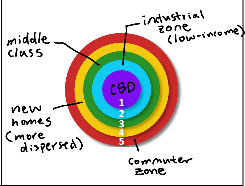
Concentric Zone Model
A theory of urban development proposed by sociologist Ernest Burgess, which describes cities as growing outward from a central area in a series of concentric rings.
Example: Chicago, USA.
Significance: It provides a framework for understanding urban spatial structure and the socio-economic gradients within cities.
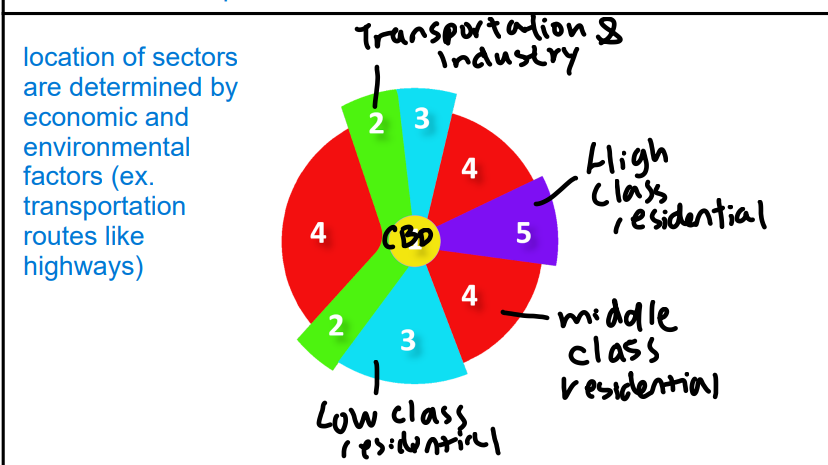
Sector Model
A theory of urban land use developed by Homer Hoyt, which posits that cities develop in sectors along transportation routes, with different land uses radiating outward from the central business district.
Example: Detroit, USA.
Significance: The Sector Model helps explain the spatial organization of cities based on transportation corridors and land value gradients.
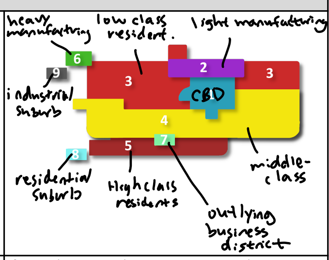
Multiple Nuclei Model
A theory of urban structure proposed by Chauncy Harris and Edward Ullman, suggesting that cities have multiple centers of development, each with its own specialized activities.
Example: Los Angeles, USA.
Significance: This model challenges the idea of a single central business district and highlights the complexity of urban spatial organization.
Census Tracts
Small, relatively permanent statistical subdivisions of a county or equivalent entity that are updated by local participants prior to each decennial census.
Example: Census tracts in New York City, USA.
Significance: Census tracts are used for collecting and presenting demographic data, aiding in urban planning, resource allocation, and policy formulation.
Edge City
A relatively large urban area situated on the outskirts of a city, typically featuring a mix of office, commercial, and residential developments.
Example: Tysons, Virginia, USA.
Significance: Edge cities represent a shift in urban development patterns towards decentralized, suburban locations and have significant implications for transportation and land use planning.
Squatter/Informal Settlements
Residential areas in urban areas where housing is typically constructed illegally or informally, without proper infrastructure or government approval.
Example: Favelas in Rio de Janeiro, Brazil.
Significance: Squatter settlements are manifestations of urban poverty and housing shortages, highlighting socio-economic inequalities and the challenges of urban governance.
Filtering
The process by which housing units move from being occupied by higher-income households to lower-income households over time due to deterioration and neglect.
Example: Older urban neighborhoods in the United States undergoing demographic changes.
Significance: Filtering reflects the dynamic nature of urban housing markets and impacts neighborhood demographics, property values, and community development.
Urban Renewal
The redevelopment of deteriorating areas within a city, often involving demolition, renovation, and infrastructure improvements.
Example: The regeneration of Docklands in London, UK.
Significance: Urban renewal initiatives aim to revitalize urban areas, improve living conditions, and stimulate economic growth but can also lead to displacement and gentrification concerns.
Public Housing
Government-owned or subsidized housing provided to low-income individuals or families.
Example: Housing projects in various cities around the world.
Significance: Public housing programs address the need for affordable housing but also raise issues related to segregation, poverty concentration, and housing quality.
Gentrification
The process of wealthier individuals or groups moving into a deteriorating urban area, often resulting in rising property values, displacement of lower-income residents, and cultural changes.
Example: Brooklyn, New York City, USA.
Significance: Gentrification has complex social, economic, and cultural impacts, raising questions about housing affordability, neighborhood identity, and social equity.
Megacity vs Metacity
Definition: A megacity is a very large urban agglomeration with a population exceeding 10 million people, whereas a metacity is an even larger urban area, typically with a population exceeding 20 million people.
Example: Tokyo, Japan (metacity); New York City, USA (megacity).
Significance: Megacities and metacities are focal points for studying urbanization, infrastructure, and socio-economic challenges on a global scale, impacting regional and international dynamics.
Annexation
Annexation refers to the incorporation of a territory into another geopolitical entity, typically a larger one.
Example: When a city expands its boundaries to include nearby suburban areas, it is said to annex those areas.
Significance: Annexation has significant implications for governance, taxation, and resource allocation within the newly expanded jurisdiction.
Redlining
Redlining is a discriminatory practice in which banks and other financial institutions refuse or limit loans, mortgages, insurance, etc., within specific geographic areas, often based on race or ethnicity.
Example: Historically, certain neighborhoods with predominantly minority populations were marked in red on maps by lending institutions, indicating they were high-risk areas for investment.
Significance: Redlining has had lasting effects on urban development and socioeconomic disparities, contributing to the creation and perpetuation of segregated neighborhoods and unequal access to resources and opportunities.
Metropolitan Statistical Area
A Metropolitan Statistical Area is a geographical region with a relatively high population density at its core and close economic ties throughout the area.
Example: New York-Northern New Jersey-Long Island MSA.
Significance: MSAs are important for understanding urban and regional dynamics, as they help policymakers and researchers analyze economic, demographic, and social trends within these defined areas.
Micropolitan Statistical Area
A Micropolitan Statistical Area is a smaller urban area with a population of at least 10,000 but less than 50,000.
Example: Pullman, Washington, a city with around 34,000 residents, is considered a micropolitan statistical area.
Significance: Micropolitan areas often have distinct economic and social characteristics compared to larger metropolitan areas, and they play a role in regional development and planning.
Density Gradient
Density gradient refers to the change in density (usually population density) over a distance in a given area.
Example: In urban areas, population density typically decreases as one moves away from the city center, creating a density gradient.
Significance: Understanding density gradients is crucial for urban planning, transportation infrastructure development, and resource allocation within cities.
Sprawl
Sprawl refers to the unplanned, often rapid, and uncontrolled expansion of urban areas into surrounding rural areas.
Example: Suburban sprawl, where low-density housing developments spread outward from the city center into previously undeveloped land.
Significance: Sprawl can lead to various environmental, social, and economic challenges, including traffic congestion, loss of agricultural land, increased pollution, and social segregation.
Greenbelt
A greenbelt is a designated area of undeveloped land, typically surrounding or bordering urban areas, preserved for recreational, environmental, or agricultural purposes.
Example: The Greenbelt around Washington, D.C., is a protected area of forests, parks, and open spaces.
Significance: Greenbelts help mitigate urban sprawl, preserve natural habitats, provide recreational opportunities, and contribute to the quality of life for urban residents.
Smart Growth/New Urbanism
Smart Growth and New Urbanism are urban planning strategies that emphasize sustainable development, mixed land use, walkability, and community engagement. Prevents sprawl.
Example: Mixed-use developments that combine residential, commercial, and recreational spaces in compact, pedestrian-friendly neighborhoods.
Significance: These approaches offer alternatives to traditional urban development patterns, promoting more efficient land use, reduced car dependency, and enhanced social interaction and quality of life.
Zoning ordinances
Zoning ordinances are local regulations that dictate how land can be used within a specific area, typically divided into zones with different permitted uses (e.g., residential, commercial, industrial).
Example: A zoning ordinance might designate one area for single-family homes, another for retail businesses, and another for manufacturing facilities.
Significance: Zoning ordinances play a critical role in urban planning and land management, helping to shape the physical and social characteristics of communities while managing potential conflicts between different land uses.