Diurnal Energy Budget and Urban Climates
1/28
Earn XP
Description and Tags
Flashcards covering key vocabulary related to diurnal energy budgets, global circulation patterns, and urban climates.
Name | Mastery | Learn | Test | Matching | Spaced | Call with Kai | Chat |
|---|
No analytics yet
Send a link to your students to track their progress
29 Terms

Diurnal Energy Budget
Balance between incoming solar radiation and outgoing terrestrial radiation during a 24-hour period.

Incoming Solar Radiation (Insolation)
Energy received from the Sun that warms the Earth's surface during the day.


Outgoing Radiation
Heat lost by the Earth to the atmosphere and space at night, mostly as infrared radiation.

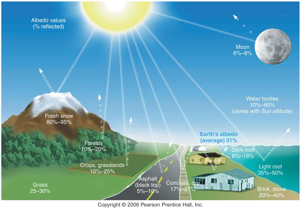
Albedo
Reflectivity of a surface; measures how much sunlight is reflected rather than absorbed.


High Albedo Surfaces
Light-colored surfaces that reflect most sunlight, resulting in lower temperatures (e.g., ice and snow).


Low Albedo Surfaces
Dark-colored surfaces that absorb more sunlight, warming the surface (e.g., forests or oceans).
Excess Radiation
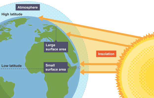
The Sun's energy is most intense at the equator due to direct overhead sunlight, creating warm temperatures.
Deficit Radiation
Sunlight is spread over a larger area near the poles and is less intense, leading to colder temperatures.
Atmospheric Circulation
Warm air rises at the equator and moves toward the poles, while cooler air from the poles moves toward the equator, creating global wind patterns.

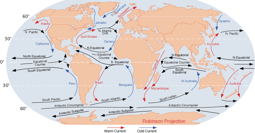
Ocean Currents
Transfer heat by moving warm water from the equator towards the poles, and cold water moves from the poles toward the equator.

Air Pressure
Weight of the atmosphere pressing down on Earth's surface.
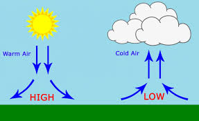
High Pressure Areas
Regions where air is sinking, creating clear skies and calm weather.
Low Pressure Areas
Regions where air is rising, leading to cloud formation and stormy weather.
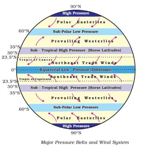
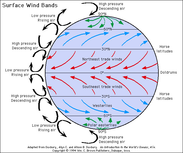
Equatorial Low Pressure Belt
Low pressure at the equator caused by rising warm air; also known as the Intertropical Convergence Zone (ITCZ).


Subtropical High Pressure Belt
High pressure areas around 30° north and south of the equator where air that rose at the equator cools and sinks.

Subpolar Low Pressure Belt
Low pressure areas at about 60° latitude where warm air from the subtropics meets cold air from the poles.

Polar High Pressure
High pressure at the poles caused by sinking cold air.
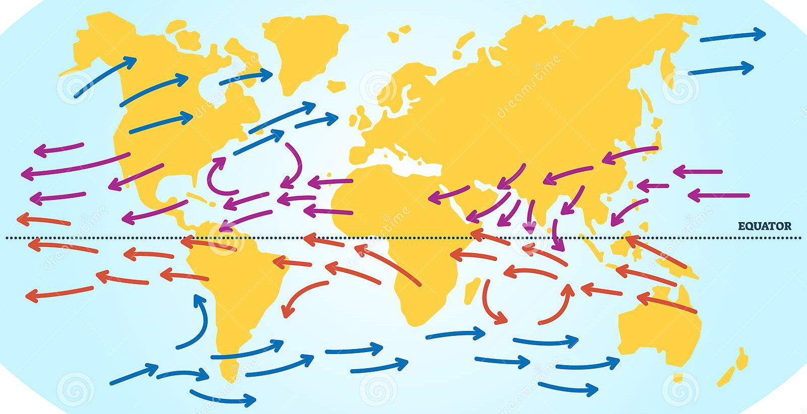
Trade Winds
Winds that blow from the subtropical high-pressure areas towards the equator, deflected by the Coriolis effect.
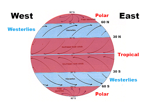
Westerlies
Winds in the middle latitudes (30°–60°) that blow from the west towards the east, driven by pressure differences.

Polar Easterlies
Winds near the poles that blow from the east to the west.
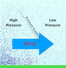
Pressure Gradients
Air moves from areas of high pressure to low pressure; the stronger the difference, the stronger the wind.
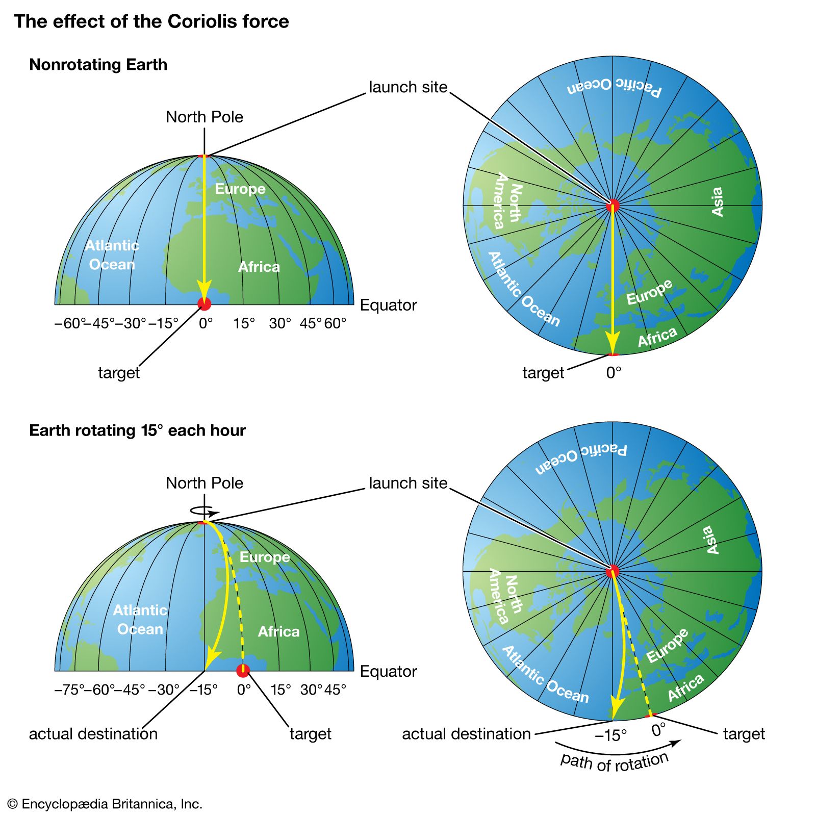
Coriolis Effect
Due to Earth's rotation, moving air is deflected to the right in the Northern Hemisphere and to the left in the Southern Hemisphere.

General Circulation Model (GCM)
Simplified model that explains the movement of air around the globe based on temperature, pressure, and wind patterns.
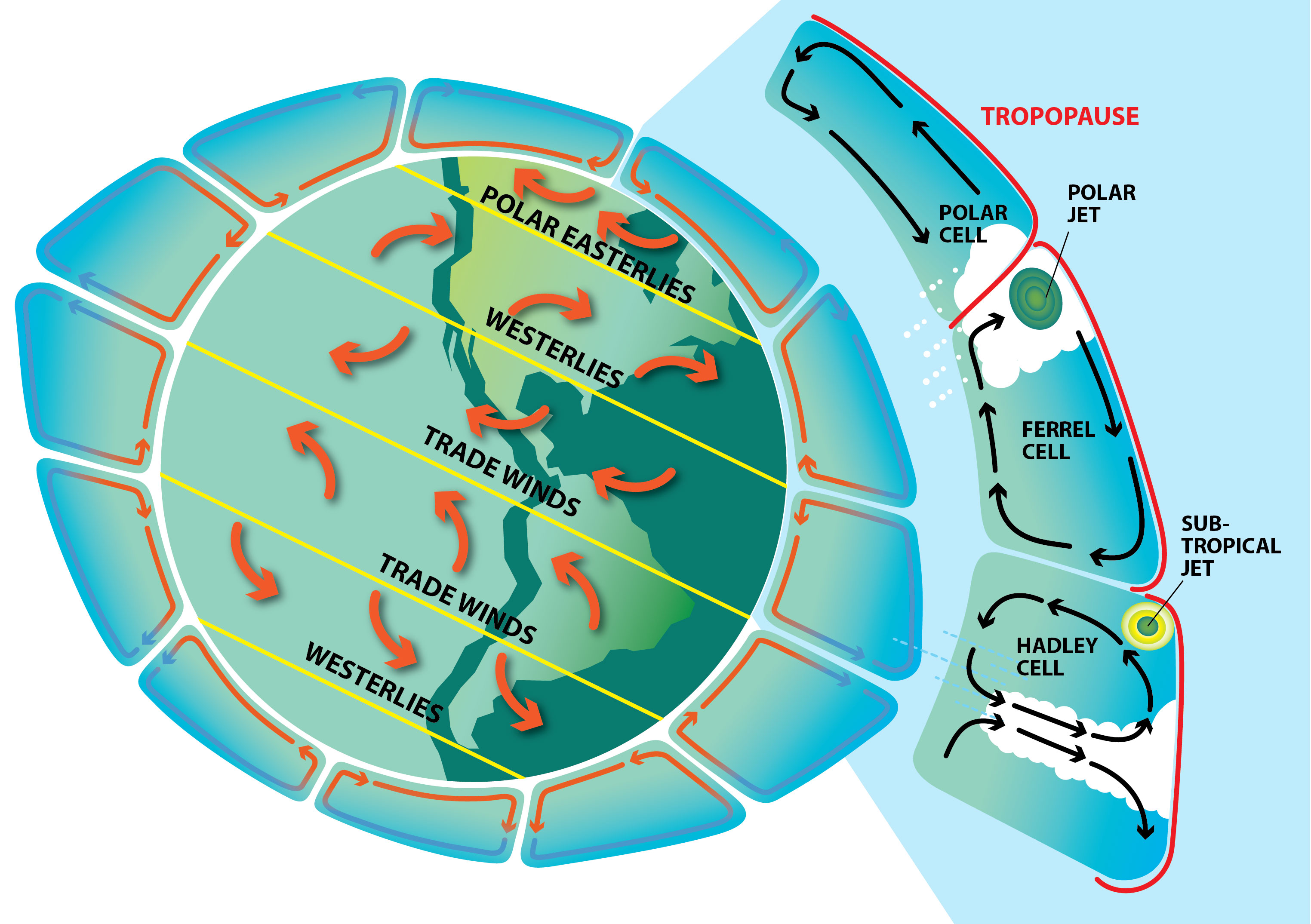
Hadley Cell
Warm air at the equator rises and moves toward the poles, sinking around 30° latitude, creating the trade winds and subtropical high-pressure areas.

Ferrel Cell
In the middle latitudes (30°–60°), air is forced to rise at low-pressure areas and sinks at high-pressure areas; area where the westerlies occur.

Polar Cell
Cold air sinks at the poles and moves toward the equator, creating the polar easterlies.

Urban Climates
Climatic characteristics that are different in urban areas compared to surrounding rural areas, influenced by human activities.
Urban Heat Island (UHI)
Increase in temperature in urban areas compared to surrounding rural areas, caused by human activities such as dense buildings and concrete surfaces.
Canyon Effect
Tall buildings block wind and create areas of low air movement, preventing heat and pollutants from being dispersed.