Periglacial Landscapes
1/22
There's no tags or description
Looks like no tags are added yet.
Name | Mastery | Learn | Test | Matching | Spaced | Call with Kai |
|---|
No analytics yet
Send a link to your students to track their progress
23 Terms
Permafrost
Permanently frozen ground, covering more than 24% of exposed land surface in northern hemisphere
Continuous Permafrost
Occurs with ground temperatures of less than -5 degrees Celsius. Maximum depth is 1400m in Serbia and 1000m on Ellesmere Island (the depth of permafrost relates to air temperature and geothermal heat)
Discontinuous Permafrost
Occurs with mean annual air temperatures of less than -1 degree Celsius. Dependant on local conditions and breaks horizontally and vertically into islands and separate masses
How does continuous and discontinuous permafrost change with altitude
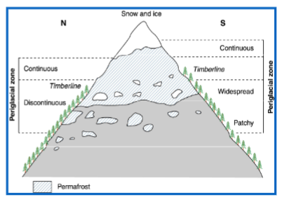
How does continuous and discontinuous permafrost change with latitude
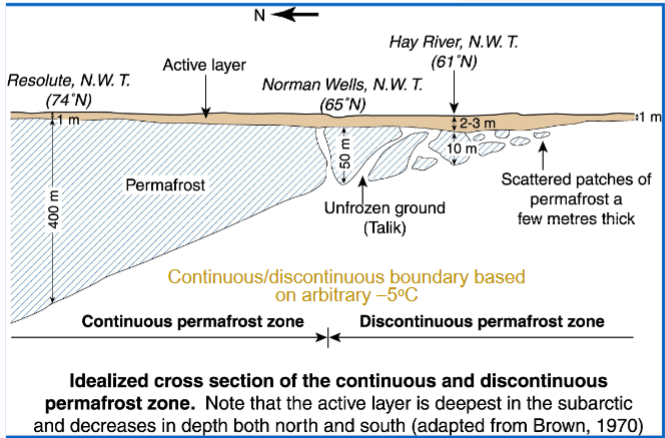
Taliks
Areas of unfrozen ground surrounded by permafrost
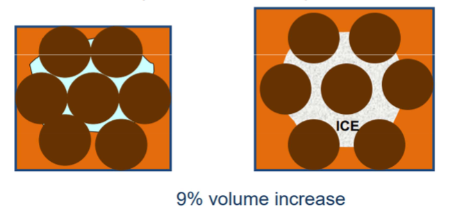
Pore Ice
Where water filters between soil particles and freezes, causing a 9% volume change
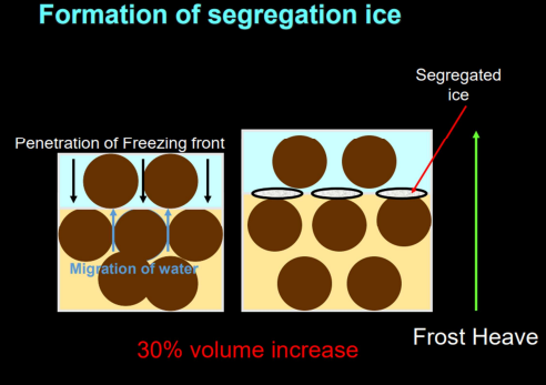
Segregation Ice
Where as sediment freezes, water can be attracted to the freezing front and form bands or layers of clear ice. This can result in up to 30% volume increase resulting in frost heaving
What are the controls on segregation ice
-Moisture -needs sufficient water to be attached to the freezing front
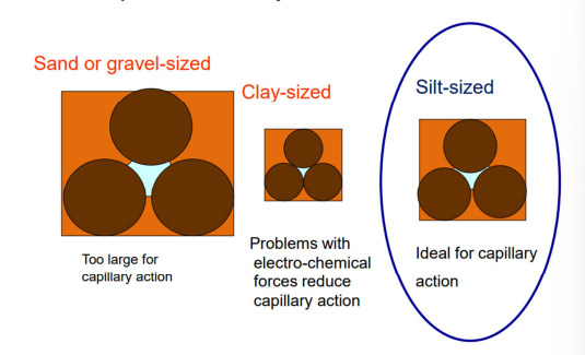
-Grain Size -needs silt-sized particles
-Rate of cooling (slow) -to allow sufficient water to be bought to the freezing front and freeze into segregation ice
-Variations in materials and microtopography -can cause differential frost heave
Frost Heave
The raising of the ground surface as a result of ice accumulation. If settlement after the thaw is less than the heave, then the surface will remain elevated
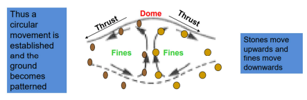
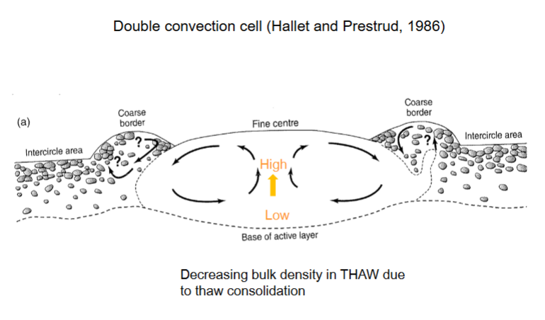
Cryoturbation
Collective term to describe all soil movements due to frost action (repeated freezing and thawing) (also sometime called involutions)
Relic Cryoturbation Structures
Structures where fine material is active. Lobes of fines injected into surrounding materials suggest high pressures. Sometimes the feeder for these lobes is visible and occasionally diapirs are forced down from above
Sorted Patterned Ground
Bare fines surround course material
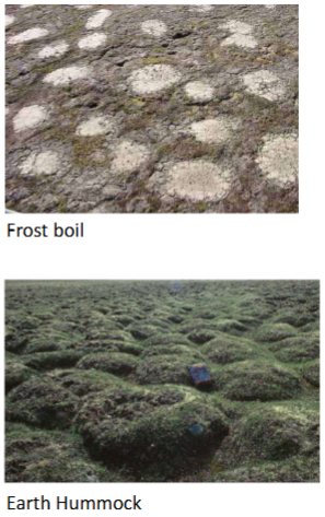
Non-Sorted Patterned Ground
Vegetation defined:
-Has thin vegetation
-Circles and nets =Frost boils
-Slope =Non sorted stripes
Relief defined:
-Has thick vegetation
-Circles and nets =Earth hummocks (Thúfur in Iceland)
-Slope =Earth hummock steps or stripes
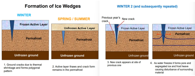
Thermal Contraction Cracking
Ground ice expands as it freezes (either pore or segregated ice) and once the water is used up then it can contract and crack. The amount of cracking depends on exact nature of material, but a key element is rapid cooling (begins in late Dec – early Jan)
Ice Veins and Wedges
In extremely cold places once the water is frozen in mid-winter the permafrost cracks, and these cracks form in a polygonal pattern. Cracks provides access for water from the surface and within the cracks ice forms ice wedges. The more severe the cooling, the denser the polygons. These grow in areas of continuous permafrost and when ice is melted, the cast fills with sediment.
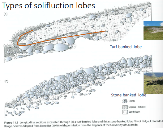
Solifluction
The slow flow of sediment down a hill, coming in two types of ground pattern: sorted (stripes) and non-sorted (stepped Earth Hummocks)
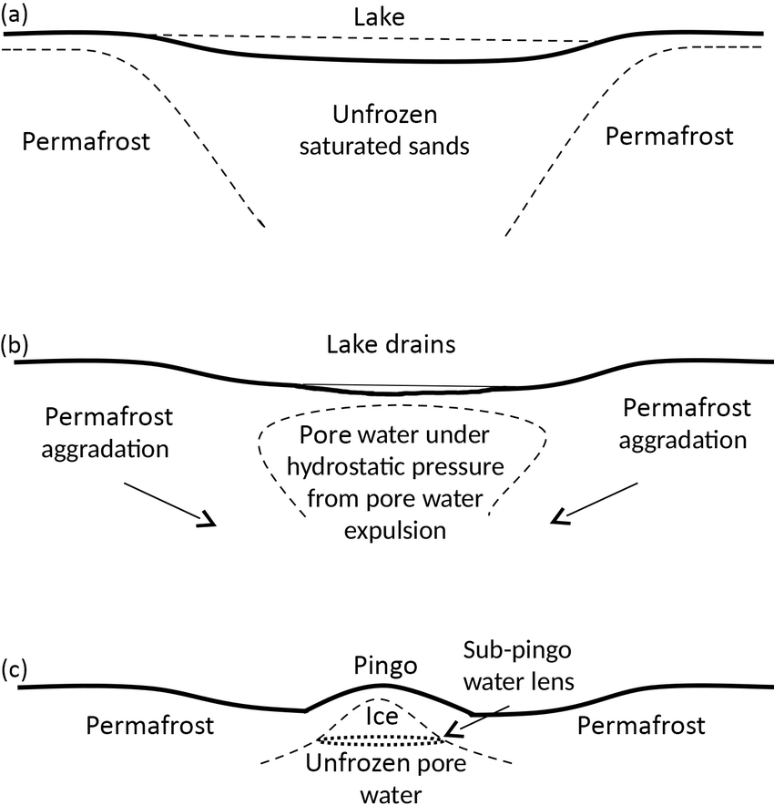
Pingo
Dome-shaped hill formed in a permafrost area when the pressure of freezing groundwater pushes up a layer of frozen ground. Contains a massive ice core (ground ice), is oval or circular in plan and ranges from 2 to 55 m high and 30 to 100 m long axis.
Hydrostatic Pingos
A lake with a talik beneath it. The lake drains and the moisture in the unfrozen area (talik) freezes from the base and sides. Water is trapped and freezes, first as segregated ice, then as intrusive ice. This pushes up the sediment above to form a hill.
Water movement is by hydrostatic pressure and occurs in continuous permafrost. Pingos continue to grow until cracks form, exposing the core and the hill subsiding
Hydraulic Pingo
Water flows beneath the ground (aquifer), but where it flows out onto the surface, it freezes, and pushes up the overlying sediment. Water movement is due to hydraulic pressure. And occurs in both continuous and discontinuous permafrost
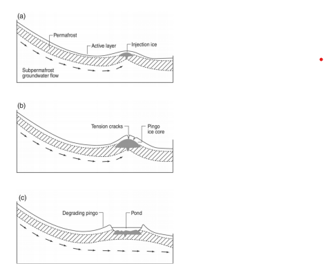
Pingo Remnants
Hydrostatic System

Hydraulic System

Palsa
Low permafrost mounds, generally formed in peat bogs in discontinuous permafrost- 0 degrees Celsius to -6 degrees Celsius. Contain a segregated ice core and oval or circular in plan and from 0.2 to 8 m high and 2-100 m long
Thermokarst Landforms
-Thermokarst/Thaw Lakes= a freshwater lake in permafrost regions, formed in depressions created by thawing ice-rich ground
-Retrogressive Thaw Slumps= dynamic landforms that occur due to the thawing of ice-rich permafrost or melting of massive ground ice, often in hillslope terrain
-Yedoma= A type of Pleistocene-age (formed 1.8 million to 10,000 years before present) permafrost that contains a significant amount of organic material with ice content of 50 to 90 percent by volume