MEA 250 Notes
1/114
Earn XP
Description and Tags
Flashcards on material up to the end of test 2
Name | Mastery | Learn | Test | Matching | Spaced |
|---|
No study sessions yet.
115 Terms
What is primarily responsible for constant changes on coast
Waves- causing erosion and deposition
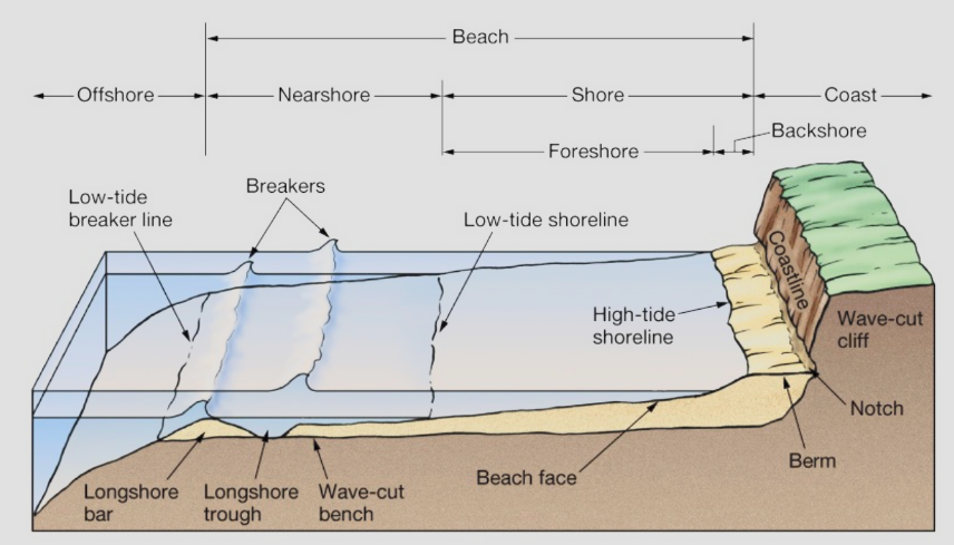
What sections of the coast make up the beach
The nearshore and shore
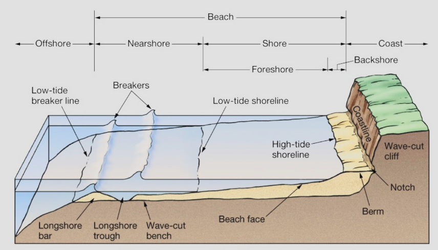
What sections of the coast make up the shore
Foreshore and backshore
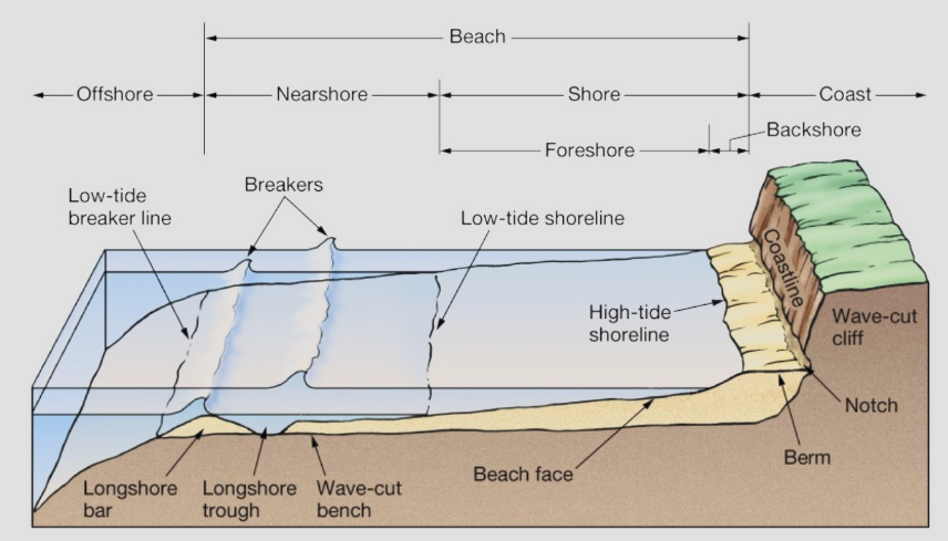
What is the area of the coast called the berm
The area from the coastline to the high-tide shoreline
What are some characteristics of erosional coasts
Well developed cliffs, tectonic activity, headlands, wave-cut cliffs with sea caves
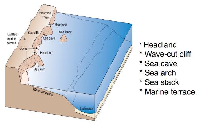
What are some characteristics of depositional coasts
Beach, spit, bay barrier, barrier islands, deltas
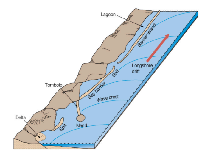
What are some characteristics of the US Pacific Coast
Steep, rugged shorelines and narrow continental shelf, active continental margin(tectonic activity)
What are some characteristics of the US Atlantic Coast
Gently sloping shorelines, wide continental shelf, passive continental margin(no tectonic activity)
What are some characteristics of the US Gulf Coast
Similar to Atlantic Coast, but smaller wave size and tidal range. Dominant feature is Mississippi River Delta
What is a Groin structure on the coast?
Extension of rock placed perpendicular to the beach to trap sand from longshore drift
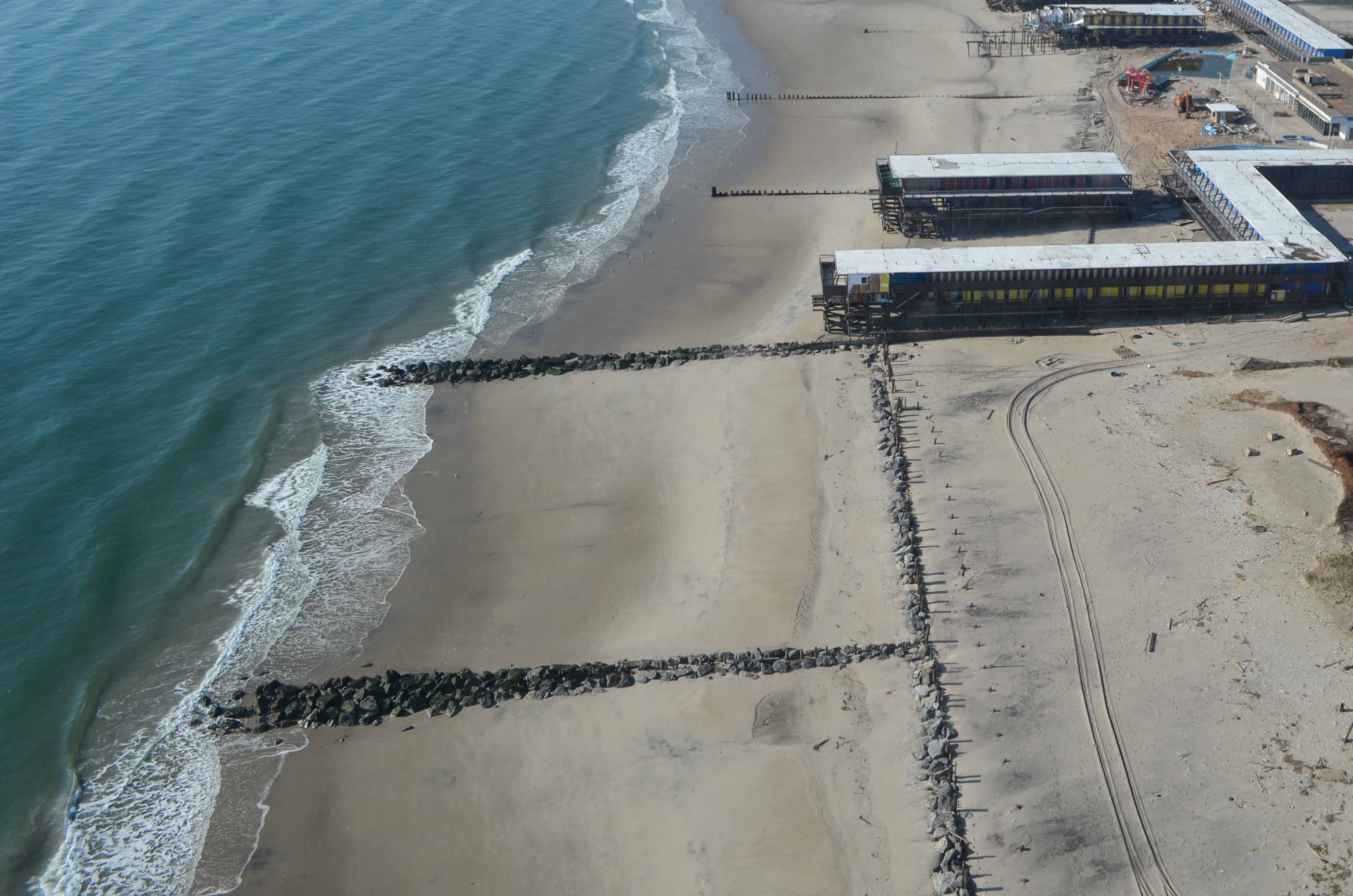
What are the negative effects of Groin structures?
They usually make erosion worse on the down-drift side of the groin
What is a Seawall structure on the coast?
Built to protect coastal cliffs and bluffs(the entire slope between a marine terrace or upland area and the sea) from eroding
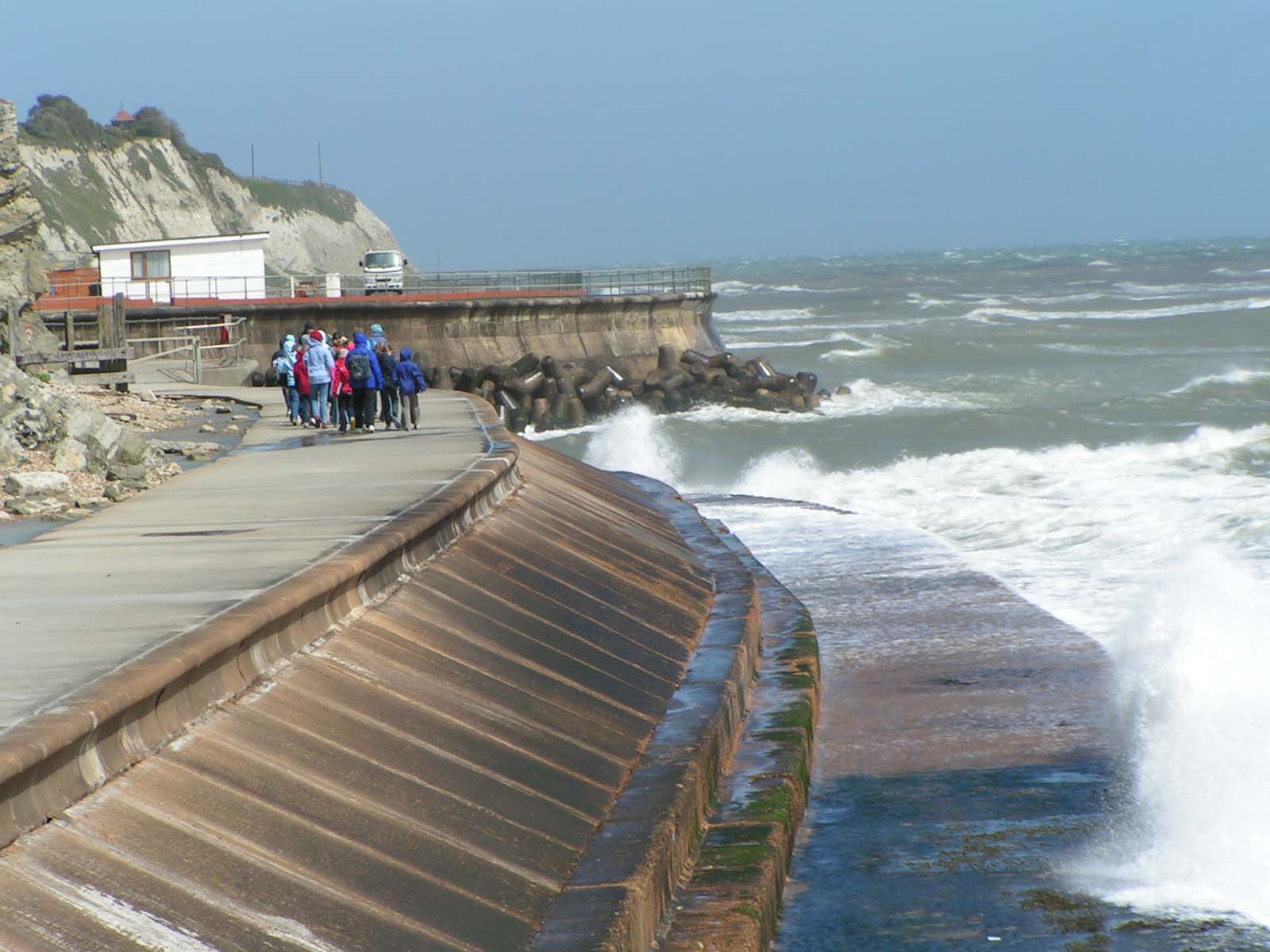
What are the negative effects of Seawall structures?
They end up eroding the beach by reflecting wave energy back onto the beach
What are the negative effects of Importing Sand structures?
Offshore sand is often finer (made up of smaller particles), so it erodes away within a short period of time
What are the layers of the Earth in order from outer to inner?
Crust, lithosphere, asthenosphere, mesosphere, outer core, inner core
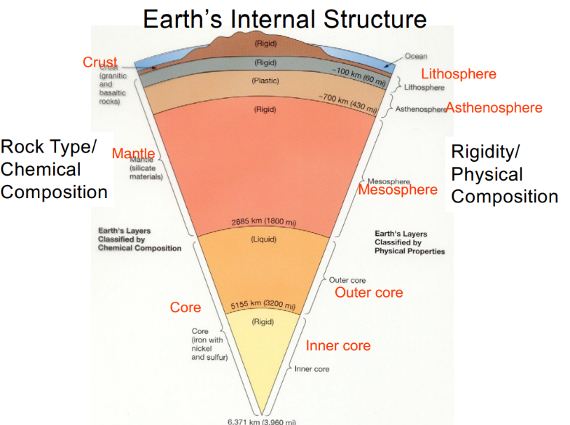
What three layers make up the Mantle layer?
In order from outer to inner: Lithosphere, asthenosphere, mesosphere
What are characteristics of the lithosphere?
Thicker than the crust, described as rigid. Includes crust and upper portion of mantle
What are characteristics of the asthenosphere?
Described as plastic (can be depressed or molded)
What metals mainly make up the outer core and inner core?
Iron (Fe) and Nickel (Ni)
What is a divergent plate boundary, as well as what is an example of one?
Where two plates separate. Example: mid-atlantic ridge
What is a convergent plate boundary, as well as what is an example of one?
Where two plates overlap. Example: Pacific ring of fire, Western Andes mountains in South America
What is a transform plate boundary, as well as what is an example of one?
Where two plates slide against each other. Example: San Andreas Fault
Where is new seafloor created?
At ridges where plates diverge. Oldest ocean is the farthest from the ridges
Difference between passive margin and active margin?
Passive margin is where there is no subduction or convergent plate boundary. Active margin is where two plates meet and subduction occurs
What part of the Earth contributes the most sediment to the ocean?
South and East Asia contribute ~70% of sediment to the ocean. This is due to tectonic activity and human activity in this area
What is the definition of sediment load?
The solid material that is transported by a natural agent, especially a stream or the mass of sediment passing through a stream cross section in a specified period of time, expressed in millions of tons.
What is the definition of sediment yield?
Sediment load per unit of drainage area. Total sediment discharge from a watershed relative to the watershed area, expressed in units of mass per unit time per unit area.
How do we calculate sediment yield?
Take the total sediment load divided by the total area
What factors can increase the sediment load for an area?
Greater rainfall/runoff, larger basin size (and larger basin size also causes decreased sediment yield, because yield is a function of total basin area)
What is the wave length of a wave?
Distance from crest to crest
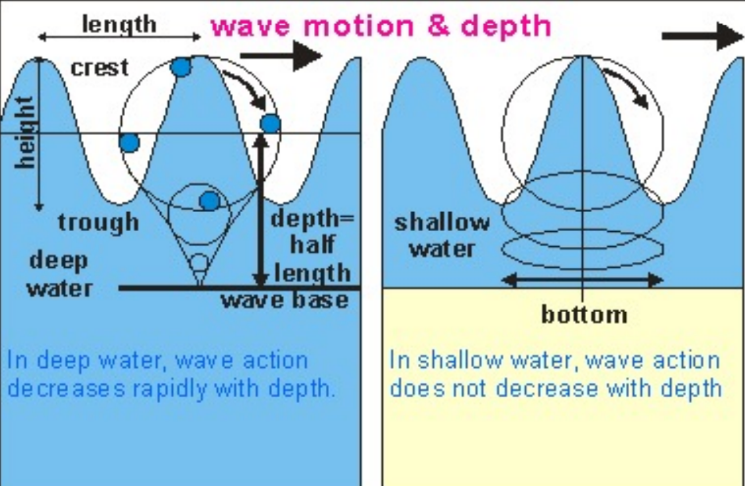
What is the wave height of a wave?
Distance from trough to crest
What is the wave frequency of a wave?
Number of waves that pass a certain point in a period of time
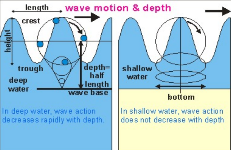
What is classified as a deep water wave?
Waves that occur where the water depth is >1/2 the wavelength
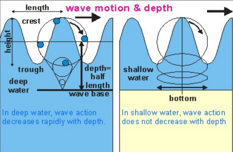
What is classified as a shallow water wave?
Waves that occur where the water depth is <1/2 the wavelength
When approaching the coast, when does a wave begin to break?
When their height to wavelength ratios are 1/7 or more
Wave sea state depends on what three things?
Wind speed, wind duration, and fetch(distance traveled)
What is the equation for wave speed of a shallow water wave?
= (gd)1/2 where g is the gravity constant and d is water depth
Waves are what type of motion?
Orbital motion- Circular motion of water as wave movement passes through
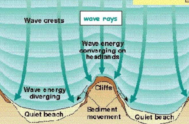
When does wave refraction occur in the ocean?
Whenever waves approach the shore and enter shallow water
When waves are refracted, where is wave energy focused?
On headlands and cliffs
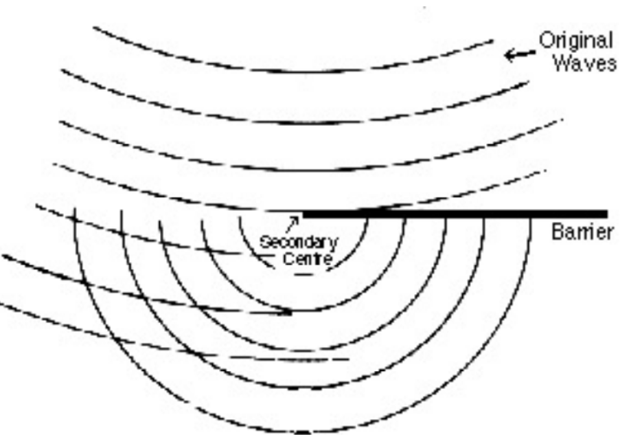
What is wave diffraction?
The process by which wave energy spreads perpendicularly to the dominant direction of wave propagation
What is the wavelength and wave height of a tsunami?
Wavelength: 100 km. Wave height: 1 m
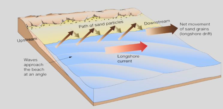
What is longshore drift?
The movement of material along a coast by waves which approach at an angle to the shore but recede directly away from it.
What is a rip current?
A relatively strong, narrow current flowing outward from the beach. Caused by convergence of longshore currents and wave set up.
What are the three types of coastal barriers?
Welded barriers, barrier spits, and barrier islands
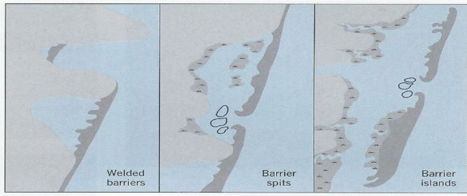
Characteristics of microtidal(0-2 meters) barrier islands
Long, narrow, few inlets, wave-dominated, overwash common
Characteristics of macrotidal(0-4 meters) barrier islands
Short and well developed, tide-dominated
What is a prograding barrier?
Barrier is moving forward(away from the land), or ‘prograding’, over time. Occurs when there is abundant sediment supply.
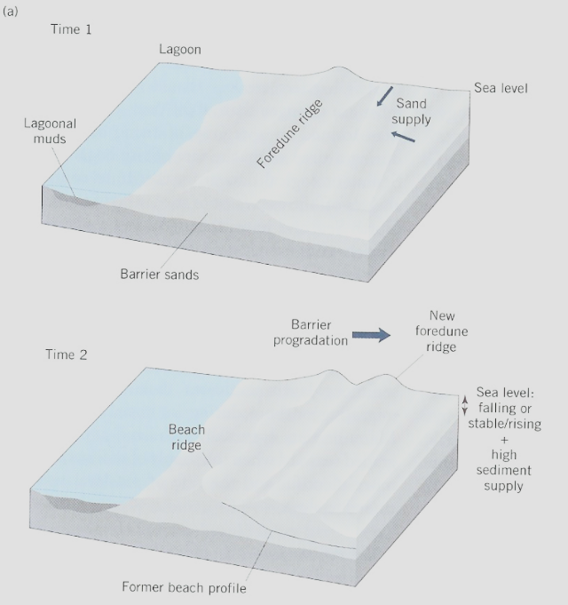
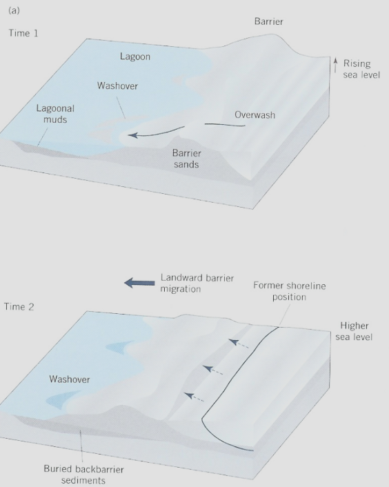
What is a retrograding barrier?
Barrier is moving back(towards the land), or ‘retrograding’, over time. Occurs when the supply of sand is inadequate.
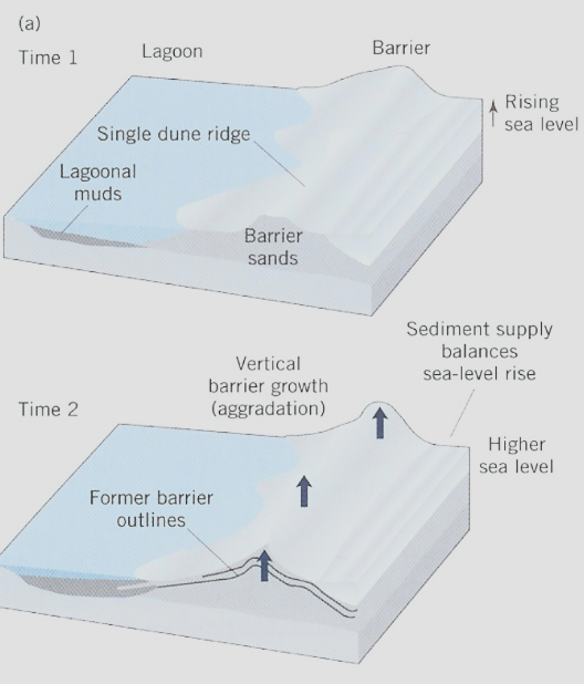
What is a aggrading barrier?
When sand builds upward due to rising sea level
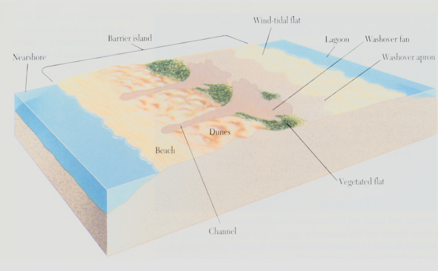
What is oceanic overwash? What are the two kinds of washover shapes that can form?
Overwash is when storm-induced waves exceed the height of the dune, sand is transported over top of the dune and deposited inland. The two shapes that can form are a washover fan and a washover apron.
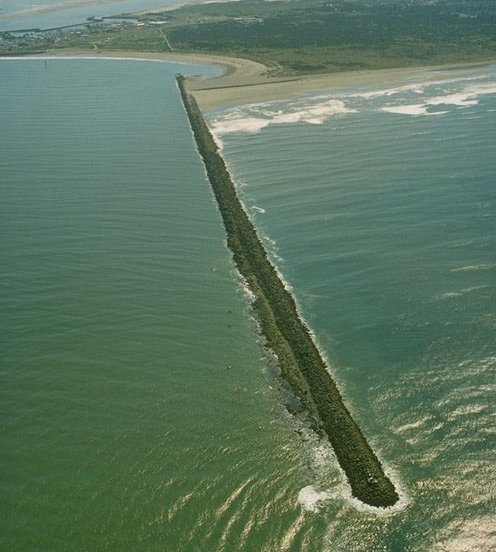
What is a jetty structure at the coast?
A long, narrow structure that intends to keep sand from flowing into a channel; intended to protect an inlet.
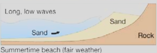
What is swash on the beach?
After a wave breaks, sediment moves toward the land

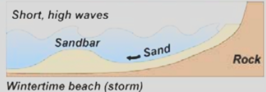
What is backwash on the beach?
Sediment moving away from the shore

Characteristics of swash dominated summer
Light waves with low energy, long wave periods, sand is transported shoreward and piles up on berm
Characteristics of backwash dominate winter
High energy waves, flatter and rockier beach, sand is stored as sandbar which will be swashed shoreward in summer
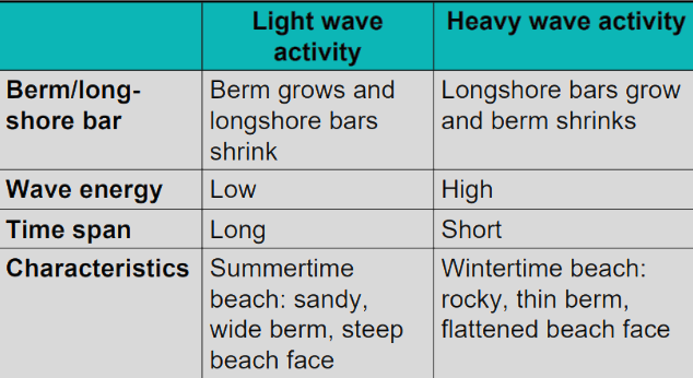
Characteristics of beaches of light and heavy wave activity (this table was emphasized to know)
What causes longshore drift?
Wave refraction causes water and sand to move parallel to shore
What does the total longshore drift depend on?
The balance between erosion and deposition, and the angle of wave approach
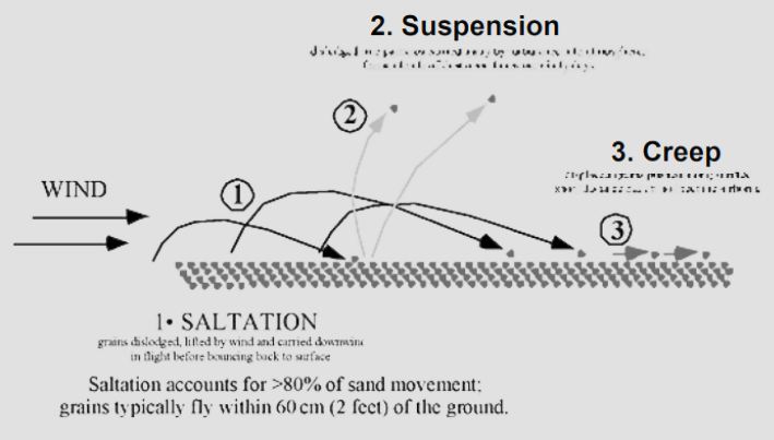
What are the three kinds of movement of sand caused by wind?
Saltation, suspension, creep
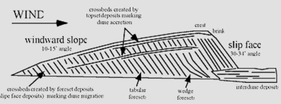
What is a transverse dune?
Elongated, asymmetrical dune. Form at a right-angle to the wind

What is a lobate dune?
Have a single isolated dune lobe formed downward from a blowout

What is a barchan dune?
Horn shaped dune pointing downwind. No vegetation

What is a parabolic dune?
Vegetation covered horn-shaped dune pointing upwind

What is the slip face of a dune?
The downward side of a dune that has a steep angle of 30-34o. It faces away from the direction the wind comes from
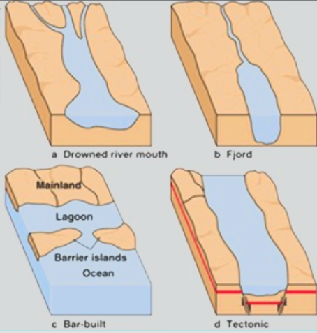
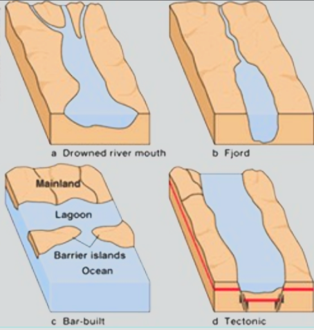
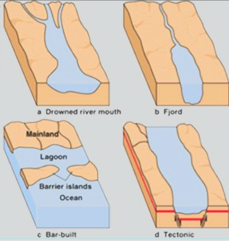
What are the four major classes of estuaries?
Coastal plain, fjords, bar-built, tectonic
Characteristics of coastal plain estuaries? Example?
These estuaries were formed at the end of the last ice age when rising seawater flooded (or "drowned") existing river valleys. Example: The Chesapeake Bay
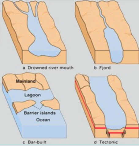
Characteristics of fjord estuaries? Example?
Glaciated, U-shaped valleys with steep walls. Example: Common Norwegian and Canadian coasts
Characteristics of bar-built estuaries? Example?
These most commonly are barrier islands that are separated from land by a shallow lagoon. They are formed by the creation of sand bars parallel with the shore, usually adjacent to slow flowing rivers that discharge freshwater into the coastal waters. Wave action plays a pivotal roll in the creation of these sand bars. Example: Outer banks, NC
Characteristics of tectonic estuaries? Example?
These are caused by earthquakes, where folding or faulting may create bays with narrow inlets to the sea. Example: San Francisco Bay
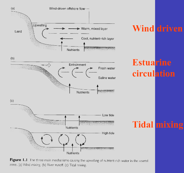
What are the main types and driving forces of estuarine circulation?
Wind-driven, tidal mixing, estuarine circulation(salt water goes under freshwater and pushes it out away from land when salt water rises)
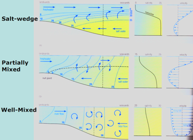
What are the three types of estuarine mixing?
Salt-wedge, partially mixed, well-mixed
What is the Estuarine Turbidity Maximum (ETM)?
The zone of highest turbidity resulting from turbulent resuspension of sediment. ETM is an important nursery area as many organisms use transport and retention within ETM.
What are some common characteristics of most estuaries?
Strong tidal forces, large density difference between river and ocean, long and narrow. Estuaries can be classified based on topogrophy or physics
What is eutrophication?
Scientific Definition: A process by which a body of water progresses from its origin to its extinction. This process happens in stages(image). When lakes, streams and estuaries are over fertilized, excessive production of aquatic organic matter can become a water quality problem and as a result the eutrophication process can be enhanced.
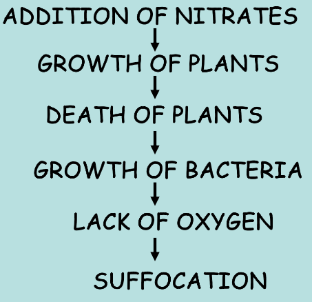
What is the Biochemical Oxygen Demand (BOD)?
This measures the rate of oxygen consumption by a sample of water, and therefore gives a good indication of eutrophication. A high BOD means lots of organic material and aerobic microbes, i.e. eutrophication.
What is a coastal lagoon?
Shallow water bodies separated from the ocean by a barrier, connected at least intermittently to the ocean by one or more restricted inlets, and usually oriented shore-parallel
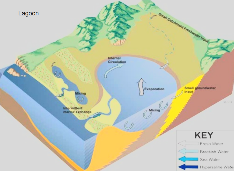
What is the difference between lagoons and estuaries?
Lagoons have little or no interchange with the open ocean or with fresh water and high evaporation rates
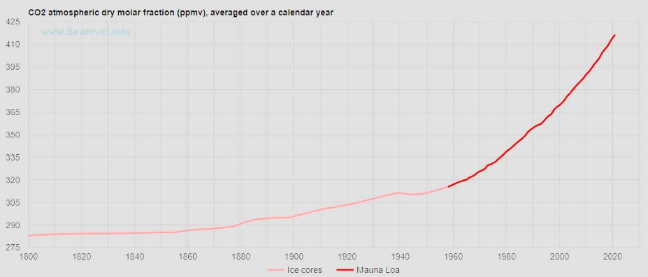
Over the past 800,000 years, what have the CO2 concentrations fluctuated between?
180 ppm and 280 ppm
When did CO2 concentration reach 400 ppm?
2013
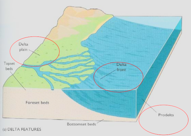
What is a delta? Examples of well known deltas?
A coastal accumulation of riverborne sediment extending both above and below sea-level close to a river mouth. Examples: Mississippi River Basin, Amazon River Basin, Mackenzie River Basin
Why is there no Columbia River Delta?
Smaller river, absence of large drainage systems preventing it from generating the amount of sediment needed. Also located on narrow and steep margins, meaning there is no proper site for sediment accumulation
What are the three main physical features of a delta?
From landward to seaward: Delta plain, delta front, prodelta
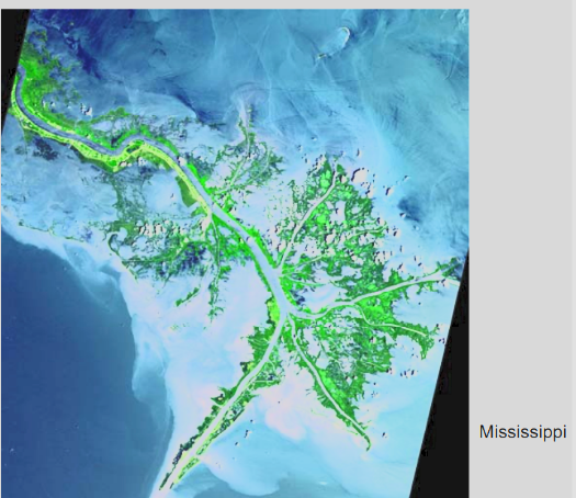
What are the characteristics of a River-Dominated Delta?
High water and sediment discharge, with small waves and low tidal ranges. A broad gently sloping continental shelf
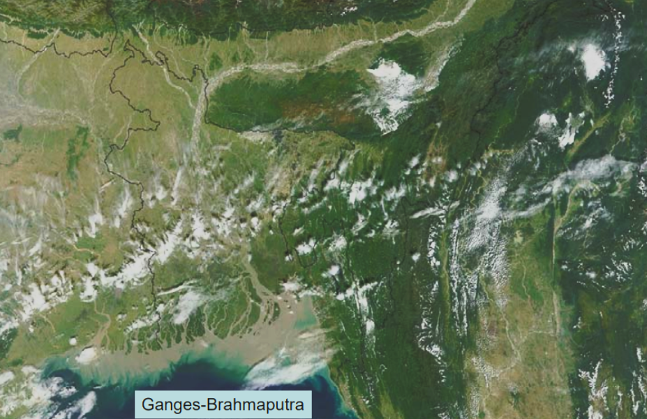
What are the characteristics of a Tide-Dominated Delta?
Strong tidal currents, without substantial wave climate and strong river influence
What are the characteristics of a Wave-Dominated Delta?
Don’t really look like a delta, relatively small, and depends on longshore current patterns
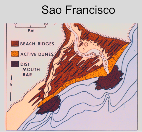
What is the definition of tides?
The vertical rise and fall of the surface of a body of water caused primarily by the differences in gravitational attraction of the moon, and to a lesser extent of the sun, upon different parts of the earth
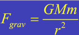
What is Newton’s Law of Universal Gravitation?(in relation to the Earth-Sun system)
M is the mass of the Sun, m is the mass of a planet (i.e., Earth), and r is the distance between them.
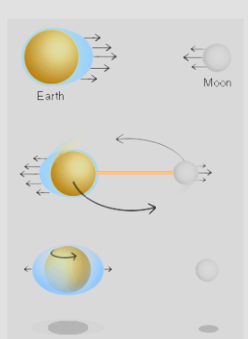
How does centrifugal force affect the tides on Earth?
Centrifugal force causes water to be bulge away from the center of mass of the earth-moon system when the earth-moon system rotates. These two forces(centrifugal+gravitational) combined cause the bottom photo, a bulge of water on both sides of earth.
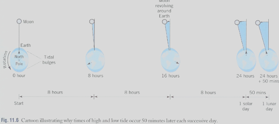
What is the period of the moon? (time to travel once fully around Earth)
Moon’s period: 27.3 days. Every 24 hour, Moon has traveled 13.2o.
After 24 hours, the moon has moved so the same spot on the earth would not be facing the moon exactly. This is why high tide in the same location occurs 50 minutes later each day, because it takes 50 minutes for the earth to rotate and catch up with the 13.2o that the moon has moved from its initial position at the beginning of the 24 hours
What are semi-diurnal tides?
Two tidal cycles daily with a period 12 hours 25 minutes. Common in majority of the world.

What are diurnal tides?
One tidal cycle daily, with a single high and low tide, period: 24hrs, 50min

What are mix tides?
during a lunar cycle: a small semi-diurnal inequality and a very pronounced one

What are spring tides?
They occur twice a month and are when the moon is between the Sun and Earth or is behind the Earth. Tides at these times are abnormally high and unusually low.

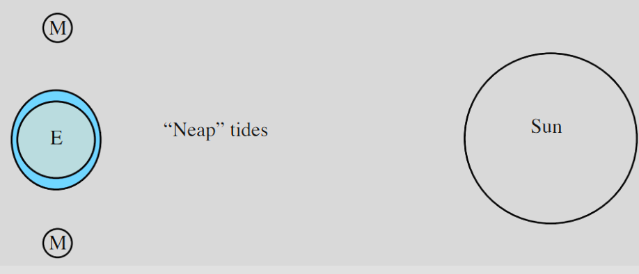
What are neap tides?
When the moon is located at right angles to the Earth-Sun line, occurs twice a month. At these times, high tides are lower and low tides are higher than usual.
What is an amphidromic point?
An amphidromic point is a point within a tidal system where the tidal range is almost zero, and around which the tidal crest rotates through one tidal cycle.
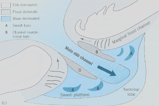
What is a ebb-tidal delta?
An accumulation of sand on the seaward side of an inlet formed by the ebb tidal current
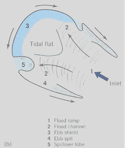
What is a flood-tidal delta?
An accumulation of sand on the shoreward side of an inlet
What is the definition of a tidal prism?
The total volume of water moving past a fixed cross section of the estuary during each flood tide or ebb tide is referred to as the tidal prism. The larger the tidal range within the estuary and the greater the dimensions of the estuary, the larger the tidal prism. On average, the ebb and flood tidal prisms are equal.
What are the four ways that tidal inlets can form?
Breaching- can occur during storms from waves destroying foredune ridge
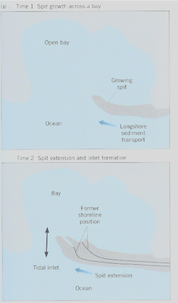
Spit building(see image)- Spits naturally forming can create an inlet by partially closing off bodies of water
Drowned river valleys- many inlets can form in these valleys
Ephemeral inlets- Develop when lake levels overtop a barrier
