Y10 Geography End of Year
1/168
Earn XP
Description and Tags
Name | Mastery | Learn | Test | Matching | Spaced | Call with Kai | Chat |
|---|
No analytics yet
Send a link to your students to track their progress
169 Terms
landscape definition
an area of land with a particular apppearance
can be any scale (big/small) and can be physical, human, or a combination of both
relief definition
the way a landscape changes in height
uplands definition
areas that are high above sea level and often mountainous
lowlands definition
areas not very high above sea level and often flat & rolling
natural/physical elements of landscapes
mountains
coastlines
valleys
plains
rivers
lakes
soils
geology
biological elements of landscapes
vegetation
marshes
wildlife
habitats
plants
human elements of landscapes
anything made by humans:
infrastructure
communications
industry
farmlands
paths
variable elements of landscapes / variables
anything that’s temporary / that changes
weather
smells
sounds
season
where are uplands found in the UK
north & west of the country
northern ireland, scotland, wales, north england
e.g. lake district, grampian mountains, snowdonia
where are lowlands found in the uk
south and east of the uk
central & southern england
e.g. cotswolds, norfolk, south downs
where are cities normally found
lowland areas, and often on main river courses
e.g. liverpool on the mersey, bristol on the severn estuary
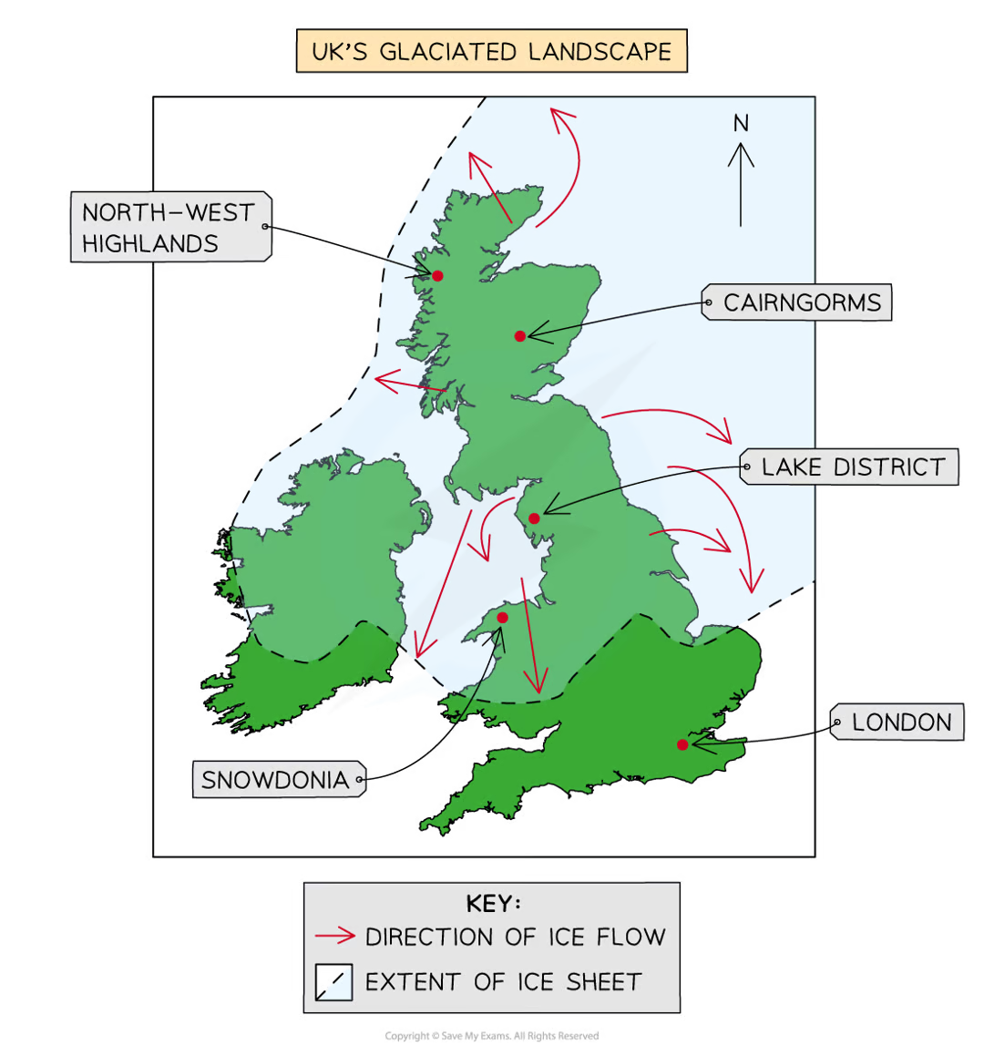
how did the ice age / glaciation affect distinctive landscapes in the uk
areas covered in ice were weathered & eroded to create steep mountain peaks and u-shaped valleys
igneous rock
forms when magma cools & hardens
hard & resistant to erosion
e.g. granite & basalt
sedimentary rock
layers of sediment are compacted together until they become solid rock
two types:
limestone & chalk come from shells & skeletons of dead sea creatures, less resistant to erosion (but limestone is harder)
clay & shales made from mud & clay minerals, much softer than limestone/chalk
metamorphic rock
formed when other rock is put under pressure & heat, it becomes harder & more compact
e.g. shale becomes slate, slate becomes schist
what rocks are the UK uplands made of
igneous & metamorphic rock
what rocks are the UK lowlands made of
sedimentary rock
human activities in glaciated landscapes
farming in the fertile land created
building settlements in the rolling plains
geomorphic processes definition
the methods involved in changing the shape of the landscape
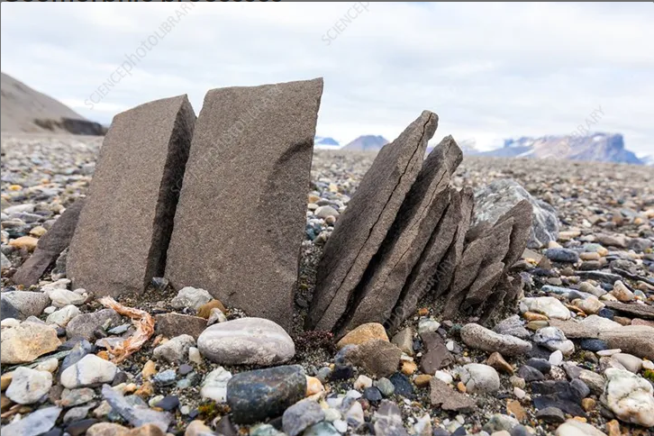
weathering
the break-down of rock in its place of origin (in situ)
different to erosion as the rock doesn’t move
three types: mechanical, biological, chemical
mechanical weathering
freeze-thaw weathering
rainwater collects in cracks in rock
water freezes into ice & expands
repeated freezing & thawing makes the crack bigger
eventually the rock splits apart
chemical weathering
acidic rain - rain dissolves carbon dioxide in the air
limestone & chalk are more easily weathered (limestone can weather to form limestone pavements)
biological weathering
caused by plants & animals
roots force their way into rocks, splitting them apart
plants e.g. mosses grow on the surface of rock, making it crumble
animals burrow into softer rocks & can trample with feet
erosion
water breaks down rock & sediment from rivers and coasts
hydraulic action, attrition, abrasion, solution
erosion: hydraulic action
waves crash against the coast, forcing air into cracks and breaking up rock
erosion: attrition
pebbles are picked up by waves and bash into each other, wearing down into smaller, rounder pieces
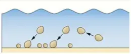
erosion: abrasion
waves pick up rocks and smash them against the coast, wearing it away
erosion: solution
some types of rock like limestone slowly dissolve in the water
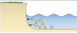
transportation
the movement of material by water
traction (boulders)
saltation (pebbles)
suspension (sand)
solution (dissolved particles)
transportation: traction
boulders & large stones are dragged along the river/sea bed
transportation: saltation
pebbles and small stones are picked up and dropped further along
transportation: suspension
tiny particles of sand / silt are carried by the water
transportation: solution
some rocks dissolve and are carried by the water, invisible to the naked eye
deposition
the dropping of material on land when the water no longer has enough energy to carry it
mass movement
erosion and weathering weaken rock, leading to surface material moving downhill
caused by gravity
sliding, slumping, rock falls
mass movement: sliding
Rock / soil moves straight down a slope along a flat surface in a sudden, linear movement
mass movement: slumping
Saturated soil moves down a slope in a curved, rotational movement, tilting backward as it slides
mass movement: rock falls
free-fall movement of rock fragments due to gravity
often increased by mechanical weathering
coast definition
a narrow zone where the land & sea overlap and directly interact
its development is affected by the interaction of physical (marine, terrestrial, and atmospheric) and human processes
beach defintion
the main feature of deposition found at the coast
material has built up between high & low mark
beach materials can be sand & shingle or others
material can be brought from the swash of waves, landslides on cliffs, and rivers transporting sediment to estuaries
swash of waves
water washed up the beach
backwash of waves
water that runs back down the beach
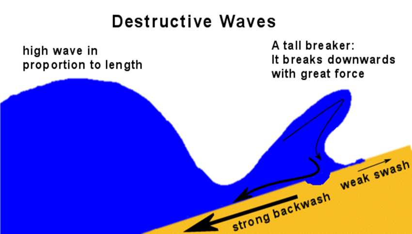
destructive waves
waves that erode beaches
high wave in proportion to length
tall breaker - breaks downwards with great force
strong backwash = erosion
weak swash
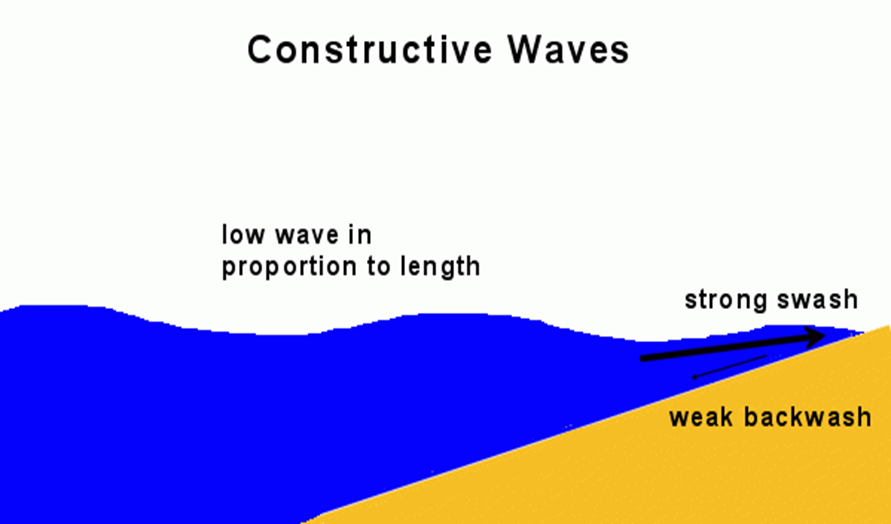
constructive waves
waves that create beaches
low wave in proportion to length
strong swash = deposition
weak backwash = material isn’t taken away
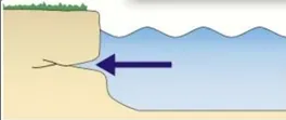
headland definition
a hard piece of rock that sticks out into the sea
bay definition
an area of coastline which has receded backwards, usually with a beach in it
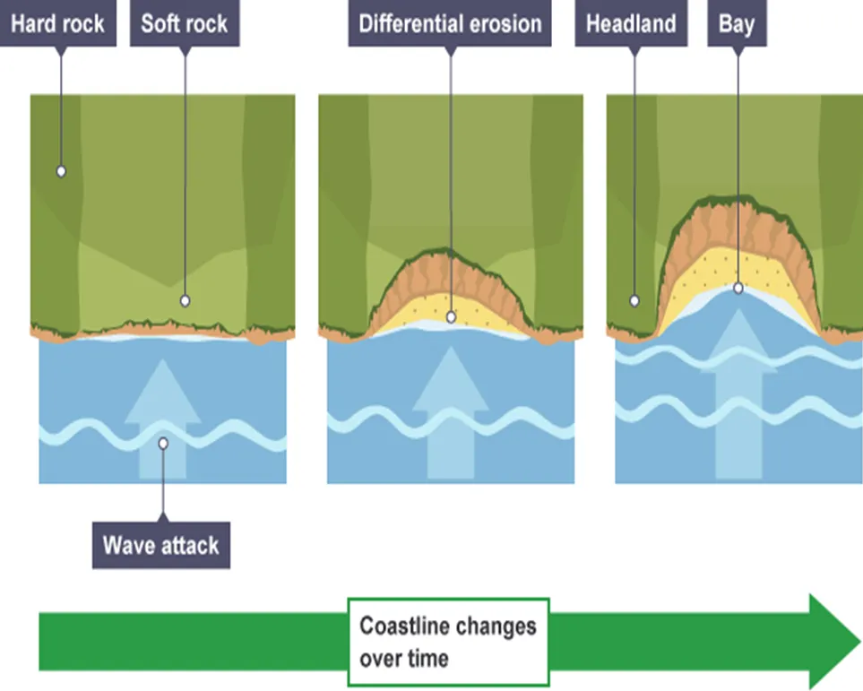
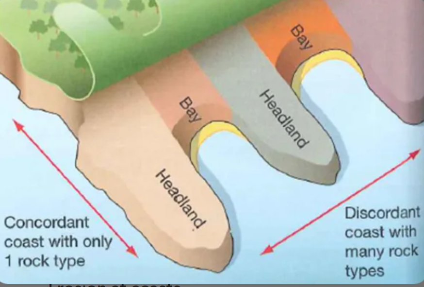
concordant coastlines
has the same type of rock along its length. creates fewer bays & headlands as there is no differential erosion
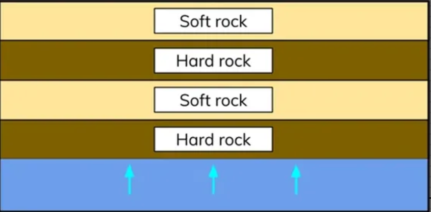
discordant coastlines
bands of different rock type run perpendicular to the coast
differing erosion speeds between softer & harder rock = formation of headlands & bays
formation of cracks, caves, arches, stacks & stumps
crack in headland is opened by hydraulic action & abrasion
crack grows into a cave
cave is eroded & becomes bigger until the back is broken through to form an arch
arch is eroded until the unsupported top collapses, forming a stack
stack is eroded around the base & falls, forming a stump
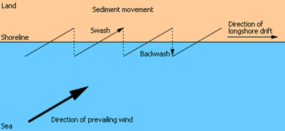
longshore drift
the movement of beach material by the sea along the coast. the direction is determined by the direction of prevailing wind
in the UK most wind comes from the south-west so beach material moves from the west to the east
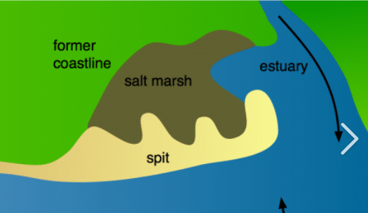
spits
an extended stretch of beach that projects out to sea & is joined to the mainland on one end
usually found at the mouth of a river
formed by longshore drift
it can grow to develop a hook if the wind direction changes further out
waves can’t get past it, forming a sheltered area behind where silt is deposited - salt marshes
purpose of costal management strategies / costal defences
to protect the coastline and the people & buildings behind it from erosion & flooding
hard engineering (coasts)
using artificial, man-made structures to stop the waves
e.g. sea walls, groins, rock armour
more expensive but more effective
used to protect high-value land
soft engineering (coasts)
smaller, more natural structures to reduce the energy in the waves to protect the beach in a more natural way
e.g. sand nourishing, offshore reefs, managed retreat
less expensive but less effective
costal defences: sea walls
hard engineering
supported walls of concrete placed at the foot of cliffs / at the top of the beach to prevent erosion
good at protecting valuable land, long lifespan, creates a promenade on top but expensive (£5k per m), ugly, destroy nature
costal defences: groynes
hard engineering
wooden fences running at right angles to the beach going out to sea, interrupt longshore drift & trap sediment as well as absorbing wave energy to reduce erosion
make a larger beach, keeps access to the sea, doesn’t destroy much of the beach but expensive (£10k each), can starve beaches downstream of sediment = erosion there
costal defences: rock armour / rip-rap
hard engineering
large boulders of rock at the base of a cliff / in front of sea walls to help the wave break & absorb its energy = less erosion
relatively cheap (£300 per m), easy to maintain, can look more natural but must fit with geology of the coast to look natural, can be hard to transport, can make accessing the beach harder
costal defences: offshore reefs
soft engineering
sandbanks built parallel to the coast out to sea, force waves to break before the beach = less wave energy & erosion
good at reducing wave energy, don’t spoil the beach, don’t effect access of beach but are very expensive (£1.3 mil each), hard to maintain, harm marine ecosystems/habitats
costal defences: beach nourishment
soft engineering
adding additional sand/shingle to the beach to make it higher & wider
relatively cheap (£3k per km), looks natural, fuller beach = more tourists but needs constant replacement because is eroded, doesn’t stop waves
costal defences: managed retreat
soft engineering
controlled flooding of low-lying costal areas to take the risk of damage away from higher-value areas
cheap compared to other defences, creates salt marshes = wildlife habitats but land is lost, landowners have to be compensated = £5-10k per hectare)
upper course of rivers
contain waterfalls, rapids, v-shaped valleys, steep relief
source is found in the mountains, starting off as a tiny trickle but tributaries increase the size
side profile is a V shape because of vertical erosion as the river erodes downwards to reach the sea
middle course of rivers
contain meanders, oxbow lakes, flatter land, floodplains, rural areas & farmland
both erosion & deposition take place
side profile is less steep and is now a U-shaped valley
lower course of rivers
contain a river mouth/estuary, very wide river, industry on banks, marshy/flat land, floodplains
deposition and lateral erosion because the river has now reached the sea so no longer needs to do vertical erosion
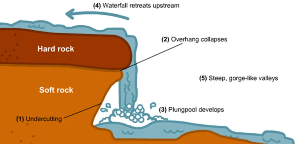
waterfalls
more resistant rock lies on top of less resistant rock. water erodes less resistant rock, forming an undercut and plunge pool. more resistant rock on top doesn’t erode, forming an overhang
eventually unsupported overhang collapses into the plunge pool
process is repeated and waterfall retreats upstream to form a gorge
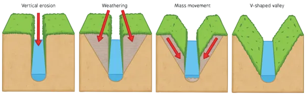
v-shaped valleys
river vertically erodes, and the steep sides of the bank weaken and eventually fall into the river channel creating the v shape
interlocking spurs
ridges of rock extending alternately, creating a zip-like formation. typically have a stream/river running between them
formed because river winds and bends to avoid the most resistant rock as it vertically erodes, meaning that non-resistant rock erode more quickly, creating an uneven appearance
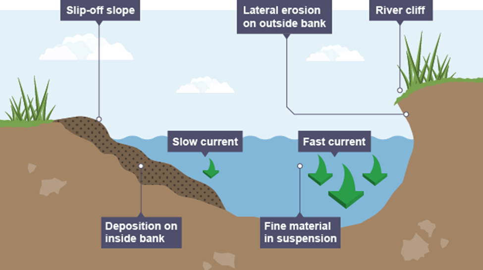
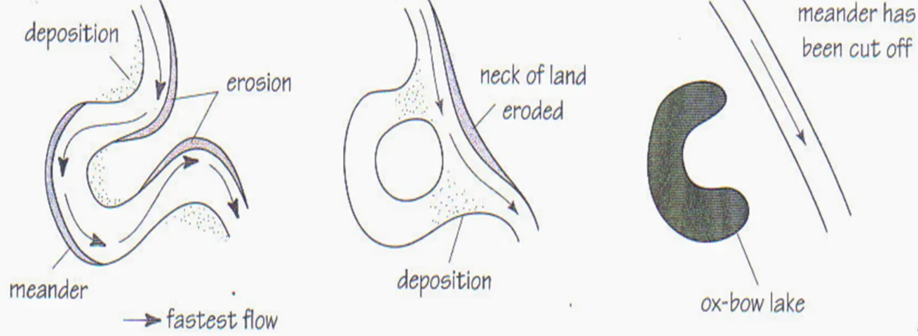
meanders
bends in a river
formed because of naturally uneven land meaning that the water naturally curves
waver moves fastest on the outside of the bend and slowest on the inside. where it moves fast on the outside, it erodes, creating a river cliff, and where it moves slowest on the inside, it deposits sediment, creating a slip-off slope. this means that smaller bends become much larger over time
oxbow lakes
still, curved bodies of water near a river
formed through meanders changing chape over time so that the bends end up joining. water takes shortest & easiest route, cutting off the bend, which becomes an oxbow lake
floodplains
the areas of land on either side of a river that are covered in water when the river floods
very fertile because of the minerals deposited there when the river floods. alluvium (fine sediment & minerals) is deposited there, creating uniquely fertile soil
often use for farming because of fertility
levees
extended banks of deposited material on the sides of rivers
formed when the river floods and deposits sediment, largest closest to the river. this means that the sediment builds up after many floods, forming levees
flooding definnition
when a river overflows its banks onto the surrounding land
discharge
the amount of water in a river
drainage basin
the area of land surrounding a river
surface run-off
water that runs over the surface of the ground towards a river
infiltration
when rainfall moves down into the ground
jurrasic coast depositional landform: chesil beach
18 miles long, from west bay to the isle of portland
can be up to 15m high and 200m wide
pebbles graded in size - biggest near portland, smallest at bridgeport - and made of flint & chert from cretaceous & jurrasic periods
jurrasic coast depositional landform: mudeford spit
winds travel south → south-west so lots of longshore drift
beach recharge used because beaches further up don’t erode so no sediment
formed from boscombe sands - compressed & soft rocklike sand
climate of jurassic coast + geomorphic processes
temp: warm dry summers (21°C) and mild wet winters (min 3°C), no freeze-thaw weathering, lots of salt weathering because evaporation of sea = salt crystals
wind: south-west winds bring storms from the Atlantic, winds bring high energy destructive waves causing erosion which cause unstable cliffs meaning mass movement
rainfall: low rainfall but can be heavy during storms, soils saturate causing slumping in winter, chemical weathering of chalk cliffs
geology of jurrasic coast + geomorphic processes
coast is made up of bands of more & less resistant rock so it has both concordant & discordant coastlines so a wide range of landforms
softer rock erodes quickly (hydraulic action & abrasion) but harder rock erodes more slowly, creating headlands & bays
rock is vulnerable to solution (seawater reacts to rock, dissolving it)
human activities at Jurassic coast + geomorphic processes
quarrying: limestone quarries on the isle of portland, exposing large areas of rock, making them vulnerable to chemical erosion
tourism: major tourist attraction, tourists erode costal footpaths & trample vegetation, exposing underlying soil & rock to weathering & erosion
coastal management: costal defences e.g. groynes change the natural landscape, alter costal processes, cause conflict between users of the coast, and alter geomorphic processes in other areas
headlands & bays in jurrasic coast
the area around swanage is made up of bands of harder rock (chalk & limestone) and softer rock (clay and sands)
this has formed studland and swanage bays, as well as durston head and ballard point
old harry rocks in jurrasic coast
on the eastern edge of the isle of purbeck
all known as old harry rocks, but ‘old harry’ is the furthest stack out to sea
until 1896 there was a second stack called old harry’s wife but erosion caused it to fall & become a stump
impact of climate change on jurrasic coast
warming temps = higher sea levels as ice sheets melt & water expands. sea level around the UK is expected to rise by 600mm by 2100
warmer atmosphere = more likely storms, creating larger & more powerful waves, increasing erosion
more intense rainfall = greater weathering of cliffs & more mass movement (more rock falls & landslides)
hold the line shoreline management plan in jurrasic coast
2005
aims - maintain/upgrade/replace costal defences to project swanage from erosion for residents & visitors
plan - 19 timber groynes to replace 75 year old ones, replenish beach with 160k tons of sand
sea walls in jurrasic coast
put in place in south swanage bay in late 1800s
extension added in late 1920s
beach recharge in jurrasic coast
in 2005, 90,000m3 of sand was deposited, and now it will need to be recharged with around 40,000m3 every 20 years
groynes in jurrasic coast
some put in place in south of swanage bay in late 1800s, and more added in 1920s
but they starved beaches further north of sediment so the scheme was extended in 1960s
they were replaced in 2005 with 19 new ones
biome definition
a large scale ecosystem, e.g. desert, rainforest, tundra
ecosystem definition
a community of plants & animals that live together and interact in an environment. the largest ones are called biomes
made of abiotic (non-living) and biotic (living) factors
main biomes & their distribution
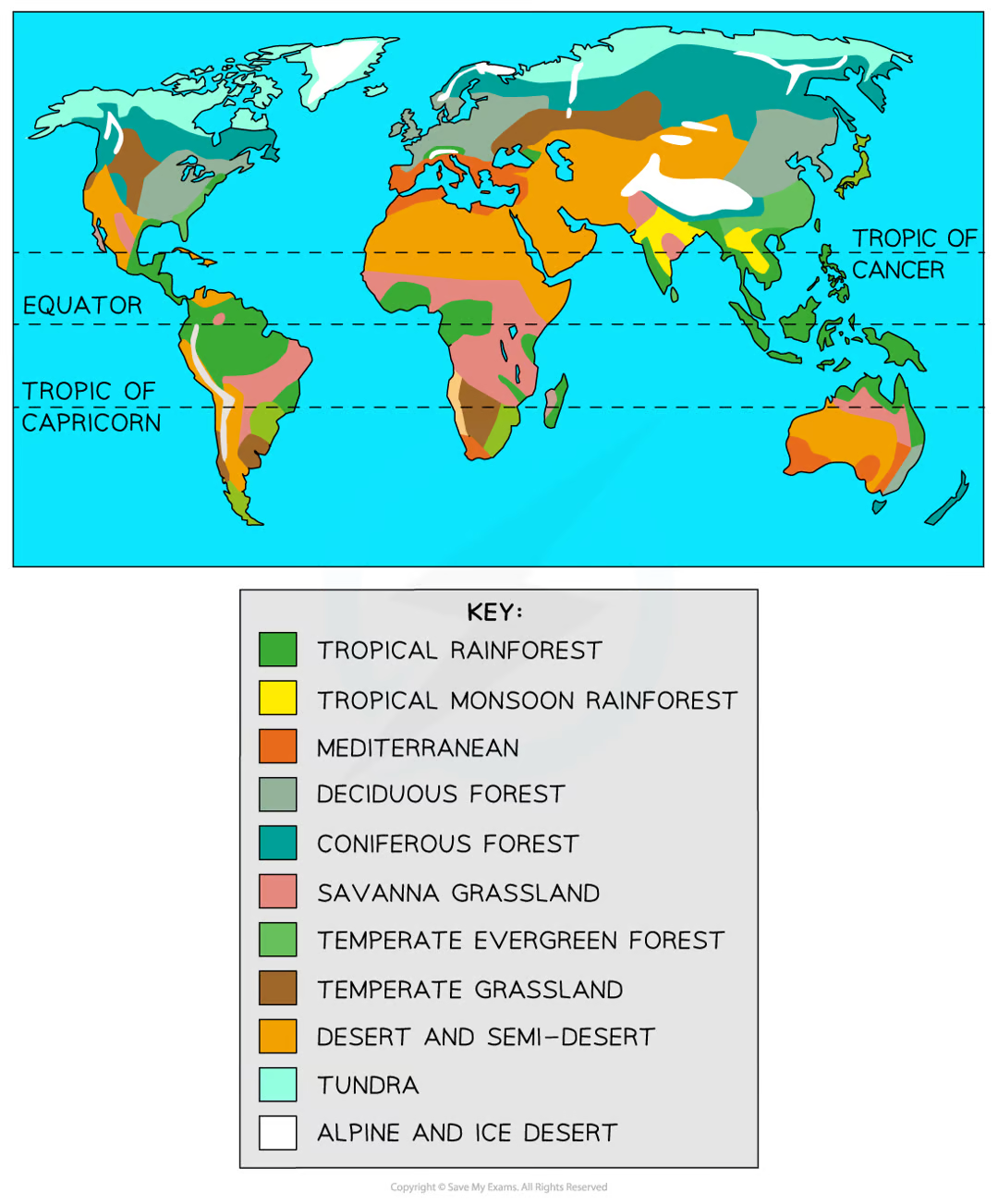
characteristics of tropical rainforests
location: low latitudes withing the tropics (around 25 degrees north & south of the equator), in south america, asia & africa
climate: lots of rainfall (2000mm annually), high temps (26-28 degrees), convectional rainfall
characteristics: ideal conditions for plant growth, high levels of biodiversity, distinct layers of vegitation
characteristics of mediterranean biome
location: around 40-45 degrees north of the equator, southern europe and north africa
climate: hot dry summers & mild wet winters, temps between 20-25 degrees in summer & 10 degrees in winter, average 800mm rainfall
characteristics: dense scrubland, herbs e.g. lavender & rosemary, citrus & olive trees
characteristics of deciduous forest
location: approx 50 degrees north of equator, europe and north america
climate: wet mild winters & warm drier summers, average temp around 10 degrees, no extreme temps
characteristics: deciduous trees (loose their leaves in winter) e.g. oak, beech, ash; wide range of animals & plants e.g. deer, rabbits, squirrels, bears
characteristics of savanna grasslands
location: 15-30 degrees north & south of equator in south america, central africa and australia
climate: distinct wet & dry seasons, temps 15-35 degrees, 800-900mm annual rainfall
characteristics: dominated by grasses, baobab & acacia trees, animals like giraffes, lions, zebras, elephants
characteristics of deserts
location: 20-30 degrees north & south of equator in africa, australia, south & north america
climate: hot daytime temps up to 50 degrees but average 25 degrees, night temps below 0, low rainfall below 250mm
characteristics: low diversity, plants e.g. yucca & cacti, animals e.g. spiders, scorpions, camels
characteristics of polar/tundra biome
location: above 60 degrees north & south of equator in the arctic, antarctic, northern Canada, siberia
climate: cold year-round, brief cool summers in tundra areas, below 0 degrees for 6-10 months, low rainfall below 250mm
characteristics: low biodiversity, short growing season, plants e.g. small grasses, lichens, mosses, animals e.g. arctic foxes, polar bears, penguins, caribou
distribution of tropical rainforests
near the equator
central america, central africa, southeast asia
cover large areas
linear pattern
none in europe
e.g. congo basin
climate of tropical rainforests
hot all year round: 25-30 degrees
because its at the equator, the sun is directly overhead at midday and it heats the ground strongly causing moist air to rise, leading to heavy rain - this means tropical rainforest are hot and wet all year round
high humidity
no seasons
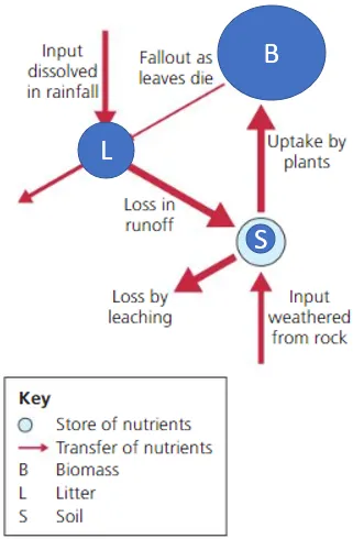
nutrient cycle of tropical rainforests
rapid nutrient cycling
litter: forest floor is hot & damp meaning dead leaves decompose quickly (within 3-4 months) so not a lot of litter
soil: because organic material decays and is recycled so quickly, few nutrients every reach the soil, so small nutrient store in soil. because of this trees have their roots close to / above the ground so they can take any available nutrients
biomass: greatest store of nutrients is the biomass - living plants & animals
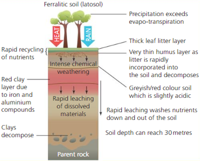
soil profile of tropical rainforest
latosols: soils found in TRFs
soils are deep (up to 30m) but not fertile - nutrient levels are low as they get used up & recycled quickly
humus layer = decomposed leaves. thin because decomposition happens rapidly
heavy rain = leaching - minerals (e.g. calcium & magnesium) get washed out of soil
top layers of soils are red due to iron & aluminium oxides left behind after leaching
chemical weathering breaks down parent (original) rock - caused by acidic rainwater. this turns the rock into regolith (broken down rock / dust) then soil