HAZARDS
 Call Kai
 Learn
Learn Practice Test
 Spaced Repetition
 Match
Match Flashcards
 Knowt Play
1/313

There's no tags or description
Looks like no tags are added yet.
Name | Mastery | Learn | Test | Matching | Spaced | Call with Kai | Chat |
|---|
No analytics yet
Send a link to your students to track their progress
314 Terms
what is the definition of a hazard
a threat which has the potential to cause injury, loss of life, damage to property, socio-economic disruption and environmental degradation
in what ways can hazards vary
nature
magnitude
frequency
geographical location
scale of impact
what is the nature of a hazard
type- e.g. volcanic
what is the magnitude of a hazard
size of the power of a hazard
what is the frequency of a hazard
how often it occurs
what is the scale of impact of a hazard
how many people it affects/ the area of land it affects
what are the classifications of hazards
geophysical
atmospheric
hydrological
biological
give examples of geophysical hazards
volcanic
earthquake
avalanche
give examples of atmospheric hazards
dust storm
cold wave
heat wave
tropical storm
drought
wildfire
give an example of hydrological hazards
flooding
give examples of biological hazards
insect infestation
infectious disease
what is risk
the probability of a hazard even occurring and creating loss of lives and livelihoods
what are the 3 types of risk
hazards to people
hazards to goods
hazards to environment
give examples of hazards to people
death/injury/illness
losing housing/possessions
give examples of hazards to goods
material possessions→ e.g. food, appliances, technology, transport
give examples of hazards to the environment
pollution→ e.g. air, water, soil, ect.
describe drought
rainfall of 50% less than the 3 month median
frequently includes extreme heat, wildfires and secondary hazard of famine
40% of the worlds land surface, containing 70% of the population and 70% of the agricultural production is exposed to drought.
describe floods
coastal, river and flash flooding occurs in over 1/3 of the world’s land areas
affects 82% of the worlds population
10% of the land’s surface is very flood prone and contains 40% of the world’s people
describe storms
cyclones can include temperate storms and tornadoes
concentration in tropical belts, especially coastal areas
covers 6.7% of the world’s land area but 24% of the world’s population
areas often developed and contain much infrastructure and GDP
describe landslides
including snow avalanches
affects 5% of the population
largely in mountainous areas
many are secondary hazards from earthquakes, floods and tsunamis
describe earthquakes
7.5% of the world’s total land area containing 20% of the pop. is earthquake prone
distribution of earthquakes concentrated along mobile plate boundaries
describe volcanic hazards
spatially concentrated
affects only 0.5% of the worlds land surface
associated with mobile plate boundaries or hotspots
describe large tsunamis
associated with earthquakes and only affect coastal areas
e.g. hawaii and indonesia
why do people continue to live in areas prone to hazards
cheaper housing
some people wouldn’t be able to move due to finances
family ties→ e.g. family living nearby
people may have adapted to overcome hazards- e.g. earthquake proof buildings
fertile soils
what is vulnerability
the conditions determined by physical, social, economic and environmental factors or processes which increase the susceptibility of a community to the impact of hazards
which factors increase vulnerability
population increase
poor infrastructure
proximity to hazard
lack of planning/education
aging population
reliance on power
environmental degradation
which factors decrease vulnerability
insurance policies
adapted infrastructure
education and planning
scientific understanding
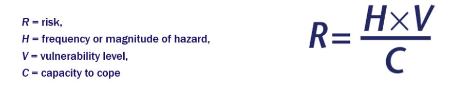
how is risk measured?
what are the most effective ways to insure accurate perception
experience
education
describe perception in hazards with low frequencys
earthquake in the High Atlas Mountains of Morocco- September 8th 2023
caused nearly 3000 deaths→ largely due to unprepared infrastructure with strong seismic shaking
little education and experience with earthquakes- low accuracy in perception
low preparation
why is education the most reliable way in hazards
reduces the risk of misinformation and a false sense of security
education can be tailored to different situations and communities
education is long-term
education can be constantly updates
give examples of education in hazards
visit disaster prevention centres (simulations of what would happen and how to deal with them
japan has disaster prevention drills once a year where the whole country is involved
describe how socio-economic status influences hazard perception
wealthier people have better constructed houses
access to internet
security could lead to overconfidence
can afford the latest gear and escape plans
describe how level of education influences hazard perception
higher education means more understanding of the risk and how to dampen effects
more education= higher accuracy of perception of the hazard
describe how occupation/employment status influences hazard perception
income level (socio-economic status)
repeated drills and training of how to deal with it
how does religion/culture influence hazard perception
fatalism→ believe god intended a disaster to happen
leads to low level of perception
describe how family and marital status influence hazard perception
married people or ppl with families are more likely to be aware of risk
responsibility
support networks
financial considerations (children and elderly)
describe how past experience influences hazard perception
high accuracy of perception of hazard due to first hand experience
will understand extent of danger, and how to learn from past mistakes
how do values, personality and expectation impact hazard perception
culture, religion
personality of indifference
what are the different approaches to perception
fatalism
Domination
adaption
fear
describe the fatalism approach to perception
acceptance
people remain where they are
acts of god
describe the domination approach to perception
suggests hazards are predictable and can be better understood by scientific research
describe the adaption approach to perception
hazards are influenced by natural and human events, magnitude and frequency can be estimated based on experience and economic and technological circumstances of the area
describe the fear approach to perception
people feel so vulnerable that they can no longer face living there and they move away
what is stage one in the park model
normality
preparation and mitigation
before the disaster occurs
describe stage 2 of the park model
hazardous event
hazard occurs with immediate damage
relief- takes hours to days
describe stage 3 of the park model
deterioration
search and rescue
short term relief and emergency services
hours to days
describe stage 4 of the park model
relief and rehabilitation
deterioration
modify the loss- e.g. aid and temporary housing and services
days to weeks
describe stage 5 of the park model
nature of recovery related to the need to restore normality and reduce vulnerability
improving after the hazard
weeks to years
improvement or return to normality
what is the hazard management cycle
cyclical structure
more simplified version of the park model
specific examples of events that will take place
no indication of a time period
describe the pre-disaster on the hazard management cycle
preparing for the hazard
risk assessment
prevention
making people aware
describe the response on the hazard management cycle
Warning and evacuation
Immediate assistance to save people-> e.g. first aid and hospitals
Assessing damage
Food and water supplies
Media focus-> lots at first and decreases over time, showing recognition.
describe the post-disaster on the hazard management cycle
reconstructing/restoration/relocation
long term international aid
economic recovery
mitigation and prevention
what are the similarities between the hazard management cycle and the park model
pre-disaster, followed by disaster, then recovery, then post disaster
both give examples of what happens at each stage
clear points where the hazard physically hits
what are the differences between the hazard management cycle and the park model
pm indicates time periods, hmc doesn’t
hmc shows media coverage
pm shows quality of life
pm has more info
pm doesn’t show the state of the country before the hazard hits
what are the weaknesses of the hazard management cycle
reductionist- actions may not always occur in the order shown on the model
shows no indication of time or quality of life- decreases predictive quality
what are the weaknesses of the park model
reductionist- actions may not always occur in the order represented in the model
time periods dont take into account wealth of the area or magnitude of the hazard
what are the strengths of the park model
shows time frames
has a curve to show quality of life
clear strategies for governments to implement at each stage
can be modelled for any hazard or emergency
what are the strengths of the hazard management cycle
can be modelled for any hazard or emergency
shows media involvement
clear strategies for governments
cyclical- constantly ongoing
describe the core of the earth
thick dense rock- iron and nickel alloys
divided into solid inner core and molten outer core
5000 degrees celsius
heat is produced from: primordial heat from earths formation, radiogenic heat from radioactive decay of isotopes
describe the mantle of the earth
made of molten and semi-molten rocks
contains silicon and oxygen
widest layer of the earth- 2900km
describe the upper mantle
rigid layer above the asthenosphere which with the crust makes up the lithosphere
the asthenophere- plastic type layer which moves slowely under high pressure and carries the lithosphere
describe the lower mantle
hotter and denser than the upper mantle
intense pressure at depth keeps the lower mantle solid
describe the crust of the earth
most abundant elements= silicon, oxygen, aluminium, potassium and sodium
lighter than other layers
oceanic and continental
oceanic is thinner and more dense
describe the lithosphere
consists of crust and upper mantle
has 7 main plates with some smaller ones
coolest and most rigid part of the earth
describe the asthenosphere
lies beneath the lithosphere it is semi molten
plates can move
700km deep
who created the theory of continental drift
Alfred Wegener
how was the theory of continental drift discovered
found identical plants and animals on the opposite side of the atlantic
close fit between the coastline of Africa and South America
`Wegener couldn’t explain why the plates moved
first continent of Pangaea
how do we know what the earth is made of
geographic surveys: seismic, gravity, magnetics, electrical
fieldwork
boreholes
mines
why is the continental crust permanent and does not sink
oceanic crust is more dense so gets subducted
continental crust does not melt due to not being subducted- therefore permanent
why is the oceanic crust not permanent
more dense
gets subducted
melts when it reaches further down in the crust due to high temperatures
reformed at divergent plate boundaries
if new oceanic plates are being formed where plates move apart, why doesn’t this mean the earth is expanding
the rate at which new crust is being created must be equal to the rate of crustal destruction
state of dynamic equilibrium
so change is occurring but the overall balance remains the same
what is vulcanicity
the process through which gases and molten rock are either extruded on the earth’s surface or intruded into the earth’s crust
clearly linked to the existence of plate boundaries
what is seismicity
the geographic and historical distribution of earthquakes
distribution is closely associated with plate boundaries
what land forms are associated with plate movement
young fold mountains
rift valleys
ocean ridges
deep sea trenches
island arcs
volcanoes
describe the distribution of magma plumes
deep plumes are concentrated more towards the equator and are in the ocean
close to plate boundaries
not a distinct obvious pattern
what is a hotspot
a stationary plume of magma
rises from deep within the earth
the tectonic plates move over the stationary hotspots which leads to the formation of a chain of volcanoes
what is a volcanic eruption
when a volcano gives of quantities of lava, ash or volcanic gas
what is a dormant volcano
not erupted for 10,000 years but it is expected to erupt again
what is an extinct volcano
hasn’t erupted for 25,000 years
not expected to ever erupt again
describe how volcanoes are built
often of divergent or convergent plate boundaries
most commonly a conical hill or a mountain that is built around a vent
built by the accumulation of their own eruptive products such as lava, bombs and tephra
where are most volcanoes concentrated
the pacific ring of fire
40,000 km long
how is magma produced
when the mantle is rising and it forces the crust to sink and melt under oceanic trenches
why are some volcanoes located in the centre of tectonic plates
hotspots
along rift valley
what is the volcanic explosivity index
VEI
every time you go up 1 magnitude the strength increases by x10
logarithmic scale
describe VEI 0 eruptions
usually quiet, effusive eruptions of lava
give an example of a VEI 0 eruption
mount erebus
southernmost active volcano on Antarcticas Ross island
frequent small eruptions
last eruption was in 2020
describe a VEI 1-3 eruption
progressively more violent explosive eruptions capable of local damage
give an example of a VEI 1-3 eruption
Nyiragongo
democratic republic of congo
last eruption was in 2020
VEI 2
destroyed over 1000 homes and led to 32 deaths
describe VEI 4-5 eruptions
moderate explosive eruptions capable of regional damage and disruption
give an example of a VEI 4-5
Mount St Helen
1980
VEI 5
Washington
describe VEI 6+ eruptions
large to gigantic explosive eruptions capable of global impact through climate modification
give an example of a VEI 6+ eruption
Mount Pinatubo
Philippines
VEI 6
1991
how are volcanoes predicted
seismometers and seismographs- allow governments to issue warnings of imminent eruption
how successful is eruption prediction
generally successful
can be aided by evidence from previous eruptions
lahar and pyroclastic deposits can aid prediction
where is the mid ocean ridge
between the african plate and the arabian plate
describe the great african rift valley
6000 to 7000 km geographical trench
stretches from Southwest Asia to Mozambique
formed by the splitting of tectonic plates
describe Mid ocean trenches
at a boundary between two oceanic trenches
regular breaks in the ridge are called transform faults
faults occur at right angles to the ridge- widen and different rates causing shallow focus earthquakes
deep rift goes along the middle of the ridges which separates two plates
magma rises at the rift and creates a new crust
what is a shallow focus earthquake
occur at a depth of less than 70km
describe rift valleys
boundary between two continental plates
the lithosphere stretches causing fractures in the faults
the land collapses into valleys which are separated by blocks of land called horsts