Tectonic processes and hazards
1/96
Earn XP
Description and Tags
Edexcel Geography A Level
Name | Mastery | Learn | Test | Matching | Spaced |
|---|
No study sessions yet.
97 Terms
What are the two classifications of tectonic hazards?
seismic and volcanic
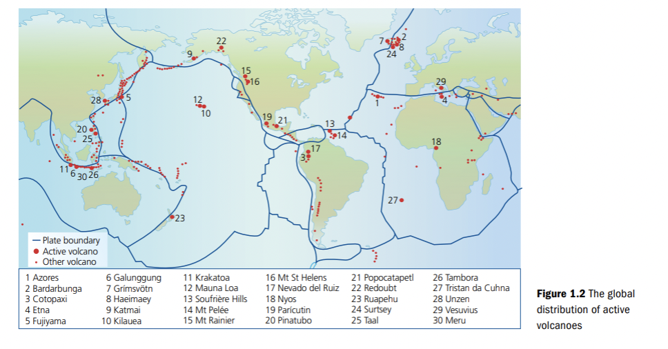
1.1 a Describe the global distribution of volcanoes
There are about 1500 active volcanoes and about 50 of them erupt annually.
Volcanic hotspots, such as the Ring of Fire, are situated amongst the centre of pates.
This is a localised area of the lithosphere (Earth’s crust and upper mantle) which has an unusually high temperature due to the upwelling of hot molten material from the core. (First theorised by Tuzo Wilson in 1963) ➔ At hotspots, such as the Hawaii hotspot, magma rises as plume (hot rock).
Volcanoes are primarily distributed along tectonic plate boundaries, with the majority found in the "Ring of Fire," a horseshoe-shaped zone surrounding the Pacific Ocean.
This region accounts for about 75% of the world’s active and dormant volcanoes due to subduction zones. Other significant areas include mid-ocean ridges (e.g., Iceland), rift valleys (e.g., East African Rift), and hotspots (e.g., Hawaii and Yellowstone).
There is a cluster of volcanoes in Indonesia and Japan along the destructive plate margin.
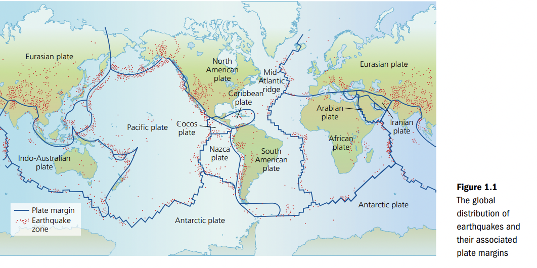
1.1. a Describe the global distribution of earthquakes
The main earthquake zones are found along plate boundaries
Roughly 70% of all earthquakes are found in the Ring of Fire in the Pacific Ocean.
The most powerful are associated with convergent or conservative boundaries but rare intra-plate earthquakes can occur.
e.g. The San Andreas Fault - conservative plate margin
also constructive- Mid-Atlantic Ridge- not as severe as destructive!
1.1. a Describe the global distribution of tsunamis
around 90% of all events occur within the Pacific Basin
Most are generated at subduction zones
particularly many off the Japanese- Taiwan island arc, South America and the Aleutian Islands
extra? What is the oceanic fracture zone (OFZ)
a belt of activity through the oceans along the mid-ocean ridges, coming ashore in Africa, the Red Sea, the Dead Sea Rift and California.
An oceanic fracture zone is a zone of lithospheric weakness generally perpendicular to the axis of the mid oceanic ridge
extra? What is the continental fracture zone (CFZ)
a belt of activity following the mountain ranges from Spain, via the Alps, to the Middle East, the Himalayas to the East Indies and the Pacific.
1.1.a/c Where do a small minority of earthquakes occur?
Along old fault lines e.g. the Church Stretton Fault in Shropshire
1.1c Define a seismic hazard
generated when rocks within 700km of the Earth’s surface come under such stress that they break and become displaced
1.1c Define a volcanic hazard
associated with an eruption event
1.1c When does an intra-plate earthquake occur? and why?
occurs in the middle of plates
much rarer than boundary earthquakes
causes not yet fully understood
assumed that plates have pre-existing weaknesses which become reactivated
forms seismic waves
e.g. solid crust weakens over time and can crack under pressure
e.g. 2011 Mineral, Virginia 5.8
stupid way to understand: a super calm person is unlikely to snap often but if things keep happening to them then the pressure builds up and they can explode.
1.1c What is a volcanic hotspot?
A localised area of the lithosphere (Earth’s crust and upper mantle) which has an unusually high temperature due to the upwelling of hot molten material from the core. Here magma rises as plume (hot rock)
A hotspot is when one of Earth's outer tectonic plates moves over an unusually hot part of the Earth's mantle (magma/mantle plume) and large amounts of magma rise up, piercing through the plates and producing large volcanic eruptions at the Earth’s surface e.g. Kilauea, Hawaii, Yellowstone
1.1c Outline how hotspot volcanism has led to the development of the Hawaiian islands.
You should refer to examples volcanic activity present in Hawaii and the types of landforms such as shield volcanoes that are produced. How do landscapes such as the Hawaiian islands change over time.
The Hawaiian Islands were formed by such a hot spot occurring in the middle of the Pacific Plate. While the hot spot itself is fixed, the plate is moving. So, as the plate moved over the hot spot, the string of islands that make up the Hawaiian Island chain were formed.
The Hawaiian Islands form an archipelago that extends over a vast area of the North Pacific Ocean. The archipelago is made up of 132 islands, atolls, reefs, shallow banks, shoals, and seamounts stretching over 1,500 miles from the island of Hawaii in the southeast to Kure Atoll in the northwest.
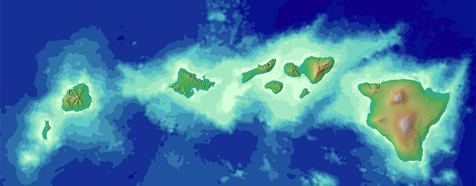
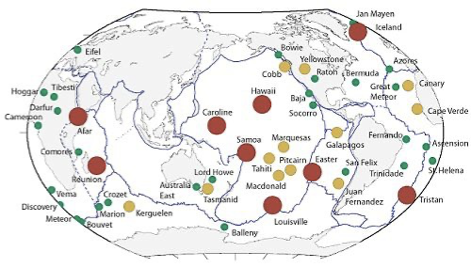
Some volcanic eruptions are 'intra-plate' meaning there are distant from a plate boundary at locations called mid-plate hotspots, such as Hawaii and the Galapagos Islands.
At these locations:
Isolated plumes of convecting heat, called mantle plumes, rise towards the surface, generating basaltic volcanoes that tend to erupt continuously.
A mantle plume is stationary, but the tectonic plate above moves slowly over it.
Over millennia, this produces a chain of volcanic islands, with extinct ones most distant from the plume's location.
stupid way to understand: I need to heat up all my food so i have a stack of plates and a hot stove- the 1st plate on the stove is heating up because hot air is rising- its spilling over quite a bit! I move the plate off and put another plate on- over time the 1st plate will cool down.
1.1c What is a mantle plume?
Where do mantle plumes occur?
areas where heat and/or rocks in the mantle are rising towards the surface. A hot spot is the surface expression of the mantle plume.
Mantle plumes occur where there are rigorous rising convection currents. In some locations these can break through overlying plates to create tectonic activity. Some current hotspots are shown on the map below. Hawaii is the most significant 'intra-plate' example.
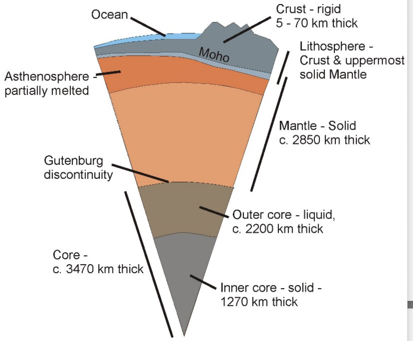
1.2a What are the characteristics of the different sections of the Earth’s internal structure?
Crust: outside layer of earth made of solid rock (basalt and granite)
There are two types of crust
Oceanic: denser and thinner, mainly basalt
Continental: less dense, thicker, mainly granite
Mantle: below the crust, up to 2900km thick. Consists of hot, dense, iron and magnesium-rich solid rock.
The upper part of the mantle and the crust make up the lithosphere and these are broken up into plates- either oceanic or continental.
Crystals in the transition zone hold as much water as all the oceans on Earth’s surface.- but as hydroxide- how cool!
The Asthenosphere is partially melted- the mechanically weak and ductile region of the upper mantle of earth- below the lithosphere
In between the core and mantle is the Gutenberg discontinuity 2900km- the velocity of seismic waves changes abruptly here
The core: centre of earth
liquid outer- nickel, iron, molten rock
solid inner
Radioactive reactions occur inside the core which produces convection currents in the mantle. This causes the tectonic plates to move.
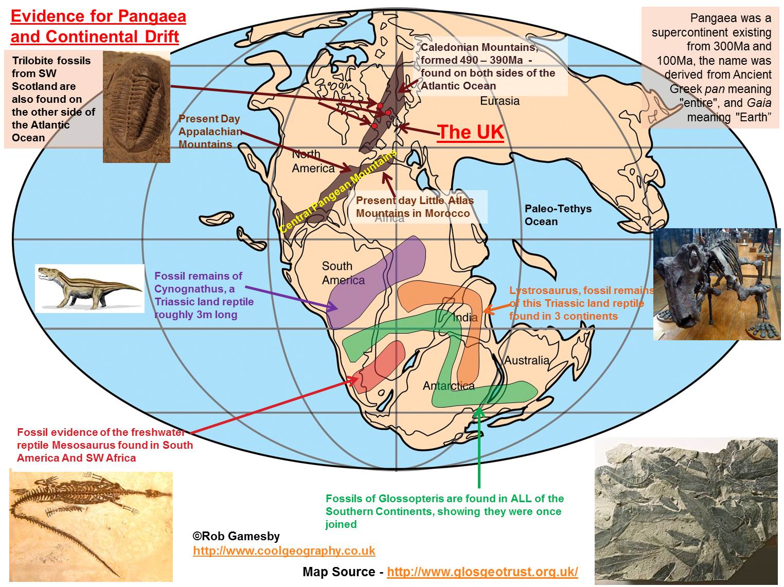
1.2a What was Pangea? and what evidence is there for the fact that the continents we know today as Africa and South America were once joined? There are 7 pieces of evidence!
A single supercontinent which comprised of North and South America, Africa and Europe. It was during the late Paleozoic Era until the very late Triassic. 300-200 million years ago. #bringbackPangea2025 #rip #makePangeagreatagain
Evidence:
Continental/Jigsaw Fit- there is a similarity in the coastlines of eastern south America and west Africa- this best fits at a depth of 1,000 metres below current sea level. Any gaps or overlaps that could disprove this can be explained by coastal erosion, deposition and eustatic and isostatic changes.
Geological Fit- Both coastlines have ancient rock outcrops (cratons) over 2,000 million years old of the same rock type. A belt of ancient rocks along the Brazilian coast, for example, matches one in West Africa.
Glacial Fit- Indications of widespread glaciation from 380 to 250 million years ago are evident in Antarctica, southern South America, southern Africa, India, and Australia. If these continents were once united around the south polar region, this glaciation would become explicable as a unified sequence of events in time and space. More evidence comes from glacial striations – scratches on the bedrock made by blocks of rock embedded in the ice as the glacier moves. These show the direction of the glacier, and suggest the ice flowed from a single central point.
Tectonic Fit- Fragments of an old fold mountain belt between 450 and 400 million years ago are found on widely separated continents today. Pieces of the Caledonian fold mountain belt are found in Greenland, Canada, Ireland, England, Scotland and Scandinavia. When these land masses are re-assembled the mountain belt forms a continuous linear feature.
Fossil evidence- The plant Glossopteris is a fern that has been found in Africa, Antarctica, Australia and South America. It is used as evidence that these continents must have at some point around 250 million years ago been joined. Mesosaurus is an extinct reptile that has been found in both Africa and South America. As Mesosaurus was a coastal animal, and therefore could not have crossed the Atlantic Ocean
Paleomagnetism- see flashcard
Marine deposits- Moreover, the earliest marine deposits along the Atlantic coastlines of either South America or Africa are Jurassic in age (approximately 199.6 million to 145.5 million years old), which suggests that the ocean did not exist before that time.
1.2a What is Continental drift? Who are some people that came up with and some geophysical evidence used to develop these theories?
The surface of the Earth is split up into a series of tectonic plates.
These move across the Earth's surface due to convection currents in the mantle.
Where the plates meet or rub against each other mountains and volcanoes may form and earthquakes may happen, sometimes causing huge waves called tsunamis.
Alfred Wegener's Continental Drift hypothesis in 1912 postulated that now-separate continents had once been joined.
Harry Hess- Sea Floor Spreading- identified mid ocean ridges, new sea floor being created
The ideas of Arthur Holmes in the 1930s that Earth's internal radioactive heat was that driving force of mantle convection that could move tectonic plates.
The discovery in 1960 of the asthenosphere, a weak, deformable layer beneath the rigid lithosphere, on which the latter moves.
The discovery in the 1960s of magnetic strips in the oceanic crust of the sea bed; these are palaeomagnetic signals from past reversals of the Earth's magnetic field and prove that new ocean crust is created by the process of sea-floor spreading at mid-ocean ridges. (seafloor spreading and palaeomagnetism occur at constructive margins, where new crust is being made) Vine and Matthews
The recognition of transform (conservative- slide) faults and Hotspots by Tuzo Wilson in 1965.
1.2a Describe and explain paleomagnetism
The alternating polarisation of new land created. As magma cools, the magnetic elements within will align with the Earth’s magnetic field, which can alternate over thousands of years. We are due another flip. The climate crisis has an effect here.
Iron particles in lava are aligned with the Earth’s magnetic field. At regular intervals the polarity of the Earth reverses; this results in a series of magnetic stripes with the sea-floor rocks are aligned alternately towards north and south poles. This striped pattern, which is mirrored exactly on either side of a mid-oceanic ridge, suggests that the ocean crust is slowly spreading away from the boundary.
1.2a Describe and explain sea floor spreading
a geologic process in which tectonic plates—large slabs of Earth's lithosphere—split apart from each other.
a process that occurs at mid-ocean ridges, where new oceanic crust is formed through volcanic activity and then gradually moves away from the ridge.
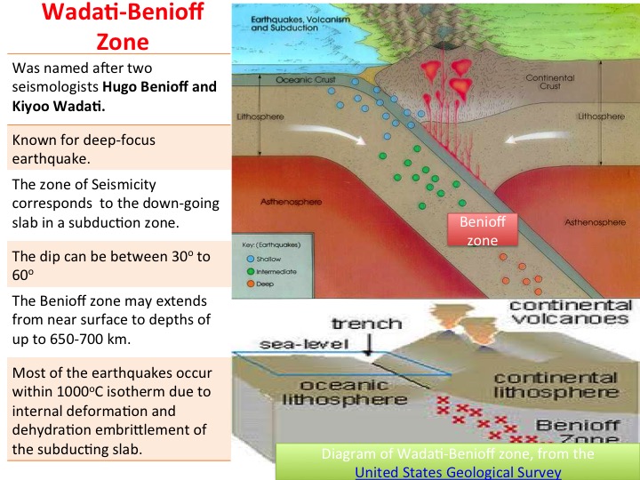
1.2c Which plate boundary type has the deepest focus and highest magnitude earthquakes
destructive will have deepest focus due to subduction along the Benioff zone- also largest magnitude
1.2c What is the Benioff Zone?
a dipping planar concentration of earthquake hypocenters that extends up to 700km into the earth
1.2c How does strength of the rock affect the earthquake magnitude and focus?
more seismic energy stored in stronger rocks- locked fault- large magnitude earthquakes when that pressure is released,
weaker permeable rocks- more liquefaction can occur
weaker rocks cannot withstand large amounts of energy.
1.2c How do seismic waves affect focus and magnitude of earthquakes?
L waves are strongest and most damage due to ground shaking, p waves are the weakest and arrive first (shunting waves)
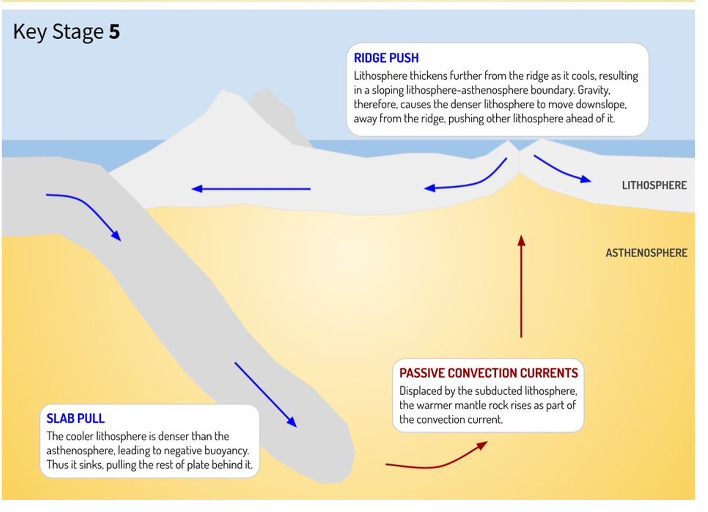
1.2a Describe and explain slab pull
As oceanic lithosphere cools, it becomes denser and thicker. At a convergent plate boundary the oceanic lithosphere sinks beneath the adjacent plate forming an ocean trench and subduction zone.
As a result of its own weight, the descending plate is pulled by gravity through the mantle asthenosphere, which is hotter and less rigid.
This force is known as slab pull. It is believed to be the major force driving plate motions.
occurs at destructive margins.
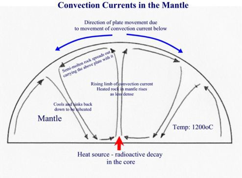
1.2a Describe and explain Mantle Convection (we’re going to ignore that its false)
Mantle convection describes the movement of the mantle as it transfers heat from the white-hot core to the brittle lithosphere.
The mantle is heated from below, cooled from above, and its overall temperature decreases over long periods of time. All these elements contribute to mantle convection.
Convection currents transfer hot, buoyant magma to the lithosphere at plate boundaries and hot spots.
Convection currents also transfer denser, cooler material from the crust to Earth’s interior through the process of subduction.
Earth's heat budget, which measures the flow of thermal energy from the core to the atmosphere, is dominated by mantle convection.
Earth’s heat budget drives most geologic processes on Earth, although its energy output is dwarfed by solar radiation at the surface.
It was long thought that this resulted in convection currents in the mantle which were responsible for the movement of tectonic plates across the Earth’s surface – indeed this is still the most common idea illustrated in many textbooks and on the internet.
However, this theory is now largely out of favour, with modern imaging techniques unable to identify mantle convection cells that are sufficiently large to drive plate movement.
Some plate models show that two thirds of the Earth’s surface move faster than the underlying mantle so there appears to be little or no evidence that convection currents in the mantle move plates (apart maybe from some very small plates in unusual circumstances).
1.2b Describe and explain elastic rebound theory- what is it?
Explains how energy is stored in rocks
overtime stresses in the earth build up
creates a locked fault (a fault that is not slipping because frictional resistance is greater than the sheer stress)
stress becomes too much (like 4 a levels) the earth breaks
Rocks bend until the strength of the rock is exceeded
Rupture occurs and the rocks quickly rebound to an undeformed shape
Energy is released in waves that radiate outward from the fault.
generally happen along fault planes or lines of weakness
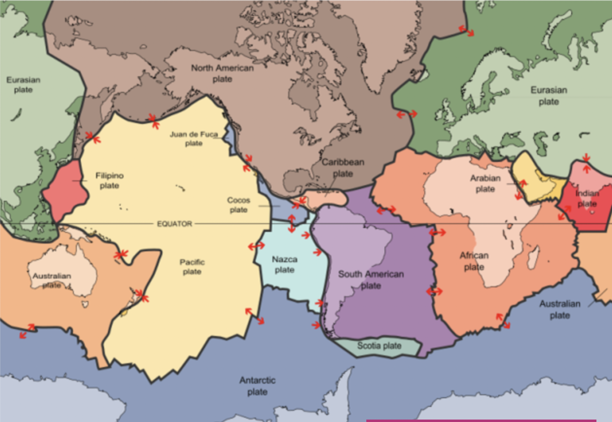
What are the names of the plates?
seven major and eight minor
Each plate is in motion relative to its neighbours, resulting in geological activity at the plate boundaries. It is also possible, though less common, for geological activity to take place in the middle of plates.
1.2a describe and explain ridge push/gravitational sliding
Where slab pull is not the main plate driver, ‘ridge push’ is another possibility.
As the lithosphere formed at divergent plate margins is hot, and less dense than the surrounding area it rises to form oceanic ridges.
The newly-formed plates slide sideways off these high areas, pushing the plate in front of them resulting in a ridge-push mechanism.
1.2a Describe the process of subduction
occurs when two tectonic plates meet at convergent boundaries
one of the plates moves under the other one due to gravity and differences in density
the heavier plate dives beneath the other and sinks into the mantle
this is a subduction zone
e.g. the Marianas Trench
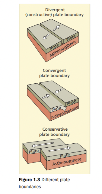
1.1b 1.2b How many types of plate boundaries/margins are there? What are they? what occurs at them? Describe and explain. How do the different processes operate at each plate margin? Distribution of plate boundaries?
A plate margin is the place where two tectonic plates meet.
The majority of plate boundaries are divergent margins with transform boundaries e.g. Antarctic plate and Pacific plate.
Plate boundaries depend on:
Motion - whether the plates are moving apart (divergent), colliding (convergent) or sliding past each other, (conservative or transform).
Plate type: whether the tectonic plates are oceanic or continental. Oceanic plates make up the ocean floor and are high density, basaltic rock, but only 7-10 km thick. Continental plates make up the Earth's landmasses and are much thicker at 25-70 km but made of less dense, granitic rock.
Divergent (constructive)
At divergent plate margins, plates are moving apart and so magma rises through the asthenosphere to the surface of the Earth.
typically occurs along a mid-oceanic ridge, like the mid-Atlantic rift that extends from the north to the south of the Atlantic Ocean.
Long chains of mountains form along these ridges. Due to the varying amount and rate of magma released mid-oceanic ridges vary in shape.
Eruptions along constructive plate margins mainly occur underwater. Pillow lavas are formed as lava is rapidly cooled on the sea floor. In the North Atlantic the extrusion of magma has been so great it created the largest volcanic island in the world, Iceland.
As magma rises the rocks above often form a dome. The lithosphere is put under great stress and eventually fractures along faults. This forms the underwater rift valleys found along mid-oceanic ridges.
Rift zones also occur on land and help explain how continents break up. The continental crust must be thin for rifting to happen. One of the best examples is Iceland’s rift valley, þingvellir. This is where the North American Plate and the Eurasian Plate are separating. A graben or sunken valley has been formed where the crust has been stretched, causing faulting.
East African rift
Corinth rift- youngest rift
Convergent (destructive)
At convergent plate margins, plates are moving towards one another. They can meet in 3 different ways:
oceanic-continental (oceanic subducts and this leads to the formation of an ocean trench- the point where the oceanic plate enters the asthenosphere. Continental crust buckles forming an oceanic trench. Sedimentary rock formed on top of the oceanic crust folds upwards along the edge of continental plate. The continental crust also lifts and buckles and magma is injected from the asthenosphere. This process forms fold mountains of which the Andes and the Rockies are examples. As the oceanic crust subducts the continental crust it melts. The magma rises as it is less dense than the material around it. Large intrusions of magma create uplift, further contributing to the formation of fold mountains. Volcanoes are formed where magma reaches the surface of the Earth.
oceanic-oceanic Where two oceanic plates converge the denser crust subducts the other. This creates a trench. As the oceanic plate descends it melts, and the magma rises forming a volcanic island chain, known as an island arc. The north-west Pacific Ring of Fire has a series of island arcs including the Aleutian Islands.
continental-continental - Where two continental plates meet there is typically no subduction. Fold mountains, such as the Alps and the Himalayas form.
Conservative
Conservative margins are also known as transform faults.
At conservative margins, plates slide past each other, so that the relative movement is horizontal, and classified as either sinistral (to the left) or dextral (to the right).
Lithosphere is neither created nor subducted, and whilst conservative plate margins do not result in volcanic activity, they are the sites of extensive shallow focus earthquakes, occasionally of considerable magnitude.
It is possible to see the boundary between plates along a conservative margin. An example of this is the San Andreas fault in California. This is where the North American and Pacific plates slide past each other.
Transform faults are mainly found on the ocean floor, where they offset mid ocean ridges and enable to ocean to spread at different rates. It was through the work of John Tuzo Wilson that these faults were recognised as the connection between the ocean ridges (divergent margins) and ocean trenches (convergent margins).
What is rifting?
A rift valley forms when the diverging plates are beneath the land. As the plates move apart, the crust stretches and fractures. Areas of crust drop down between faults to create a valley.
a rift is a linear zone where the lithosphere is being pulled apart and is an example of extensional tectonics. Typical rift features are a central linear downfaulted depression, called a graben, or more commonly a half-graben with normal faulting and rift-flank uplifts mainly on one side.
What is a megathrust earthquake and where does it occur?
occur at subduction zones at destructive plate boundaries, the earth’s most powerful with Moment magnitudes exceeding 9.0!!
a very large earthquake
The largest earthquake ever recorded was a magnitude 9.5 on May 22, 1960 in Chile on a fault that is almost 1,000 miles long
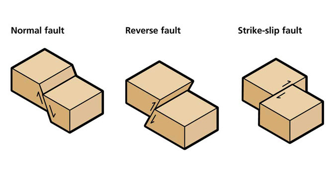
What are the 3 types of fault?
normal- the block above the fault moves down relative to the block below the fault
reverse- the block above the fault moves up relative to the
block below the fault
strike-slip- the movement of blocks along a fault is horizontal
1.3 How is an earthquake formed?
An earthquake are caused by sudden movements near the Earth’s surface (lithosphere) along a fault (zones of pre-existing weakness in the Earth’s crust)
Movements are preceded by a build-up of tectonic strain, which stores elastic energy in crustal rocks (the lithosphere). This generates a locked fault.
Pressure builds up along the fault which can cause deformation of the lithosphere.
When the pressure exceeds the shear strength of the fault, the rock fractures causing a rupture and release of energy where rocks jolt past each other.
This produces a sudden release of energy (seismic waves) that radiate away from the point of fracture (hypocentre).
The brittle crust then rebounds either side of the fracture which is the ground shaking; the earthquake felt on the surface. The lithosphere reverts to the original undeformed shape in a new locked fault.
1.3a What are seismic waves? and the four types
Seismic waves can travel both along the surface and through the layers of the earth. There are three types of waves –
P waves (primary) body: cause the immediate shock. Fastest wave. Can move through solid and liquid. Pushes and pulls the rock it moves through
S waves (secondary) body: longer wavelength and arrives seconds later. Can only move through solid rock (this includes the mantle). Moves rock up and down or side to side.
L waves (love): surface wave. Only travel through the crust causing horizontal movement
R waves: also a surface wave- travel just blow or along the ground’s surface, slower than body waves, rolling movement, especially damaging to buildings
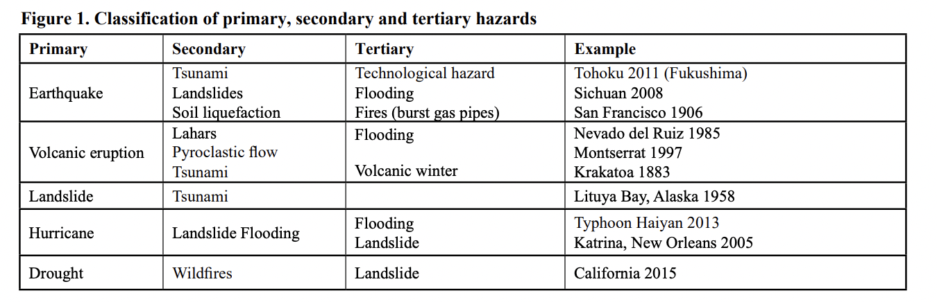
Classifications of primary, secondary and tertiary hazards
1.3a Describe liquefaction
secondary hazard
The molecules vibrate in both solids and liquids, but in solids they vibrate in place whereas in liquids they have that much more energy so they can slip and slide over each other too. In an earthquake, the molecules in the solid ground are given enough energy that they are no longer required to vibrate just in place, but are also capable of this ‘liquefaction’ – of sliding around and over each other, just like a liquid. Once the seismic waves are spent and there is no more energy being provided, the molecules go back to behaving like a solid
water-saturated sediment temporarily loses strength and acts as a fluid, undermining foundations- liquefaction
this affects loose rock and sediment. The seismic waves trigger the ground to lose its load bearing capacity, causing large buildings to settle into the ground, tilt and possibly collapse
1.3a Describe landslides
secondary hazard
degree of devastation depends on speed of onset, speed of movement, slope angle, ground saturation levels, volume of material within the slide
can lead to liquefaction
e.g. Sichuan 2008- dammed some rivers and created landslide dams which caused flash flooding when breached!
these occur where slopes are weakened by seismic waves and slide under the influence of gravity
Landslides occur when the shear stress is greater than the shear strength.
70% of all deaths from EQs globally (excluding those from shaking, building collapse, tsunami) are attributable to landslides.
e.g. 2008 Sichuan EQ landslides accounted for 1/3 of all deaths
Shear strength – the force holding the slope together (e.g. lots of trees, shallow slope)
Shear stress – the forces pulling the slope down (e.g. increasing slope angle if building a road)
1.3a Describe crustal fracturing
primary hazard
refers to significant breaks or faults in the Earth’s crust that are caused by tectonic forces, leading to the formation of large-scale fractures in the crust. This may trigger the collapse of material down steep slopes.
1.3a What is crustal deformation?
the changing earth's surface caused by tectonic forces that are accumulated in the crust and then cause earthquakes. So understanding the details of deformation and its effects on faults is important for figuring out which faults are most likely to produce the next earthquake.
1.3a Describe ground shaking
primary hazard
Ground shaking is a term used to describe the vibration of the ground during an earthquake. Ground shaking is caused by body waves and surface waves. As a generalisation, the severity of ground shaking increases as magnitude increases and decreases as distance from the causative fault increases.
What is an earthquake?
An earthquake is the sudden ground motion or vibration produced by a rapid release of stored-up energy
What is the difference between focus (hypocentre) and epicentre of an earthquake:
The location below the earth's surface where the earthquake starts is called the hypocentre and the location directly above it on the surface of the earth is called the epicentre.
1.2c Characteristics of a shallow focus earthquake
Shallow quakes generally tend to be more damaging than deeper quakes. Seismic waves from deep quakes have to travel farther to the surface, losing energy along the way. Shaking is more intense from quakes that hit close to the surface like setting off "a bomb directly under a city,"
1.2c Characteristics of a deep focus earthquake
While deep quakes may be less damaging, they're usually more widely felt. Most of the destruction in the Myanmar quake was centered in the tourist town of Bagan where nearly 100 brick pagodas dating back centuries were damaged. At least four people were killed in the Myanmar temblor, which also shattered ancient Buddhist pagodas.
What is a seismometer
A seismometer measures the amount of ground shaking during an earthquake, recording vertical and horizontal movements of the ground on to a seismograph.
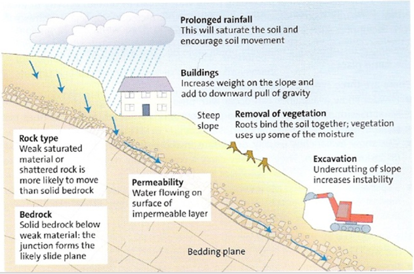
1.3a What are some changes which decrease stability of slopes?
A decrease in shear strength (upslope forces):
Weathering of rock allows water porosity of rocks to increase (freeze-thaw cycles) allowing more water to enter.
Weathering also breaks down rocks into new clay which expands when water is present (dry clay is very firm and stable)
Increasing the water content – raises the water table (can increase stress and at the same time decrease strength)
Animals burrowing – allows soil moisture to drain away
Removing vegetation – vegetation binds the soil thus stabilising slopes, the loss of root networks reduces the cohesion of the soil. Slope failures often occur several years after logging, when root systems decay away.
An increase in shear stress (an increase in the forces attempting to pull a mass downslope):
Construction
An increase in slope angle especially at the base of the slope e.g. undercutting for building a road removes the support for the slope
Increasing weight of slope due to increased water content
Shocks and vibrations from earthquakes or machinery – the shaking causes rearrangement of particles, decreasing porosity à water content change from unsaturated to saturated without adding water.
1.3c Tsunamis (another secondary hazard) some stats and how do they appear
77% of all deaths in the 2004 Indian Ocean tsunami were women
Tsunami account for 7% of tectonic disasters but 36% of deaths
Three of the top 10 most deadly disasters in recent years were tsunami (2004 Boxing Day - Banda Aceh, Indonesia; 2008 – Sulawesi, Indonesia; 2011 – Tohoku, Japan) – all at the Pacific Ring of Fire.
‘Tsunami’ is a very large wave which floods areas of the coast.
When they are out at sea, they have a very long wavelength, often more than 100km. They are very short in amplitude, at around 1m in height. They travel very quickly often at speeds of up to 700kph, for example taking less than a day to cross the Pacific.
When they reach land, they rapidly increase in height up to over 25m in some cases. They are often preceded by a localised drop in sea level (drawback) as water is drawn back and up by the tsunami. This is often the first warning of its arrival. It slows down as it approaches a land mass but as the frequency of the wave remains the same, so the height of the wave increases greatly
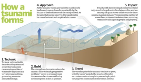
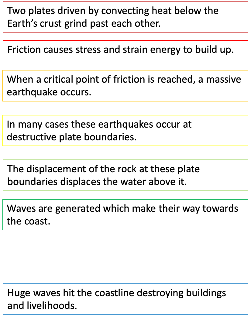
1.3c Describe and explain the two causes of tsunamis
Earthquakes
The most common cause of major tsunami is submarine earthquakes occurring beneath the seabed. The earthquake can cause a vertical displacement of the seabed, displacing water upward, which generates a tsunami at the ocean surface. Horizontal displacements of the seabed (strike-slip faults) do not tend to generate tsunami.
Volcanic collapse
These most commonly involve the eruption, or emergence, of a volcanic island. There are two main mechanisms:
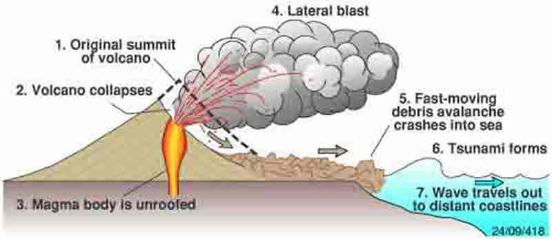
1. Flank collapse: the landslide of one side of volcano into the sea, displacing water. This is often accompanied by a lateral blast.
2. Caldera collapse: where the upper part of a volcano collapses, accompanied by a massive steam eruption as water contacts magma.
The 2018 Sunda Strait tsunami (Indonesia) involved a volcano. The island of Anak Krakatoa is formed of a volcano that emerged in the sea from Krakatoa’s crater (which famously erupted in 1883) in 1927. There was a flank collapse during the 2018 eruption created a submarine landslide and tsunami 13m high. There were 435 deaths, 14,000 injured and 3000 homes destroyed
1.3c How tsunamis occur via earthquakes
1.3c Tsunamis
Detection—very difficult to detect in open ocean— because of the small wave height but long wave length. Tsunami waves have no back- only wind driven waves do.
Run-Up - if the first part of the wave to reach the coastline is the wave trough. -There may be a lowering of sea level below normal this is called DRAWDOWN—if this is recognised then can save lives eg
As the wave approaches land, the waves energy is crowded into a smaller volume of water, therefore waves that were 1m in height in the open ocean may reach 20m
Landfall- death and destruction will depend on what? Land uses, population density, warning given, geography and relief of coastal areas
Hydrostatic- objects like boats and vehicles are lifted and carried inland. Same could occur with a backwash/rundown
Hydrodynamic- tearing of buildings apart, washing away soil, undermining foundations
Shock effects- battering by debris carried in the wave—human deaths result from drowning, hit by moving debris, lifted and battered.
Hazard hits quickly and unexpectedly but prolonged—no time to think through properly in responses- so danger wasn’t recognised
Looks like a normal wave at first BUT on reaching land , breaks and floods due to one wave with no back
Occur from earthquakes of magnitude > 6.5
Occur when the focus has a depth of < 50km
90% occur in Pacific
Over 25% occur in the Japan-Taiwan island arc (the most active source area)
Between 1900 – 1980, 370 tsunami were observed in Pacific
The greater the tsunami run up (wave height above sea level) the greater the devastation but the less frequent
If the first part of the wave to reach the coastline is a wave trough, there may be a lowering of sea level below normal levels, called a drawdown.
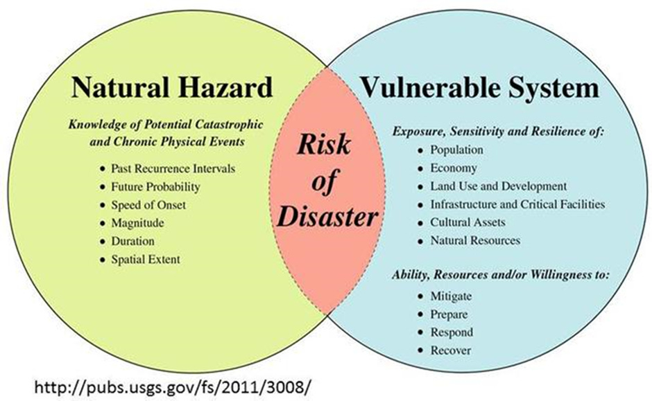
1.4a Deggs model
Degg’s model shows the overlap of natural hazard and human vulnerability.
The greater the scale of a earth process or event and the more vulnerable and exposed the people, the greater the scale of the natural hazards or disaster.
1.4c The social and economic impacts of tectonic hazards (volcanic eruptions, earthquakes and tsunamis) on the people, economy and environment of contrasting locations in developed, emerging and developing countries. see case study sheet! for specifics
social
deaths, injuries, health impacts (including psychlogical!)
economic
property loss
infrastructure loss
opportunity loss
environmental
damage/destruction of physical systems/ecosystems
It is difficult to compare impacts between countries because both the physical nature of the event and the socio economic profiles of affected places are different.
observations:
economic costs in developed and emerging economies are, in some cases, enormous
deaths in developed countries are low, except for the 2011 Japanese tsunami (a very rare megadisaster)
volcanic eruption impacts are small compared with those of earthquakes and tsunami
1.4c Which tectonic hazards have the most impact?
Volcanic eruptions: Small and declining impacts, especially death tolls
Earthquakes: Large impacts, as significant earthquakes are common and widespread
Tsunami: Very large impacts from a small number of events
1.5 a The magnitude and intensity of tectonic hazards is measured using different scales (Mercalli, Moment Magnitude Scale (MMS)
What is magnitude?
types and measurements?
Pros and cons of different scales?
Intensity?
the size of an earthquake
logarithmic basis of scale means each whole number increase represents 10x increase in amplitude.
now measurements focus on the physical effects Moment magnitude scale rather than just the waveform Richter scale
Mw- rigidity x area x slip
rigidity- strength of rock along the fault
area- area of the fault that slips
slip- distance the fault moved
a stronger rock or larger area will contribute to a larger magnitude
can also measure it by energy magnitude but these values are not the same
Fun fact: You would need ~14,000km fault length, with a seismogenic thickness averaging 40km (width of 100km), to slip and average of 30m to produce an Mw 10.
the measure of shaking at each location
varies from place to place
mainly depends on the distance from the fault rupture area.
things that affect intensity:
direction the earthquake ruptured
type of surface geology e.g. bedrock shook the least and soft mud the most at the Loma Prieta earthquake in 1989
intensities are usually expressed in roman numerals
usually measured from human observations and reports and instrumental data from different stations
Scale used is called the Modified Mercalli intensity scale I-XII
cannot be used to easily compare earthquakes as shaking experienced depends on buildin type and quality, ground conditions etc.
Why is the relationship between magnitude and death toll weak?
some earthquakes cause serious secondary impacts, such as landslides and tsunami
earthquakes hitting urban areas have greater impacts than those in rural areas
level of development, and level of preparedness, affect death tolls
isolated, hard to reach places could have a higher death toll because rescue and relief take longer
a very high magnitude could not cause any deaths in an unoccupied area
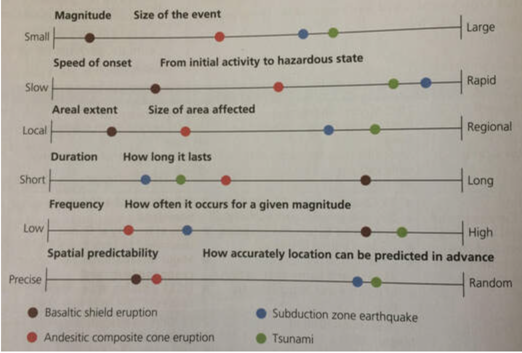
1.5b Comparing the characteristics of earthquakes, volcanoes and tsunamis (magnitude, speed of onset and areal extent, duration, frequency, spatial predictability) through hazard profiles.
for profile examples see case study sheet!
Tectonic events can be compared using hazard profiles. These allow a better understanding of the nature of hazards, and therefore risks associated which each. For example, there may be a continuous line ranging from least to greatest (for example, short to long with duration), with each hazard event located on this line (in relation to their duration in this example.) It gives more information than just ranking them, since it shows the difference between each event, and can be used to compare multiple aspects of different hazards (or different types of the same hazard, e.g. volcano).
Hazards with the following characteristics present the highest risk:
high magnitude, low frequency events - these are the least 'expected' as, by definition, they are unlikely to have occurred in living memory
rapid onset events with low spatial predictability - they could occur in numerous places and without warning
regional areal extent - affecting large numbers of people in a wide range of locations
1.5c Profiles of earthquake, volcano and tsunami events showing the severity of social and economic impact in developed, emerging and developing countries. (4)
The 2005 Kashmir earthquake ranks as one of the most destructive in recent decades.
At magnitude 7.6, with a ground shaking intensity of V!! (severe) this was a large event
As will all earthquakes, speed of onset was very rapid so there was no change of evacuating to a safe area
Damage was centred on Muzaffarabad, but spread over an areal extend of more than 1000 km^2
Ground shaking lasted 30-45 seconds, but landslides triggered by the earthquake continued for some time, as did aftershocks up to magnitude 6.4
Destruction in Kashmir was severe:
87,000 deaths
2.8 million people displaced or made homeless
17,000 schools destroyed or damaged
Nearly 800 health centres destroyed
Numerous factors including poverty. poor building construction, time of day (many children were in school), geology and terrain (contributing to landslides) and isolation (making the rescue and relief effort difficult) help explain the impacts, but two hazard profile characteristics are also relevant:
frequency: the previous major earthquake in Kashmir was in 1905, so there was no 'collective memory' of the risks and impacts of earthquakes in the region
spatial predictability: Kashmir is in a 'seismic gap' i.e. an area of known risk that had not experienced an earthquake for some time. This should have been acted upon through education and risk awareness, which could have reduced the impacts.
1.6a Inequality of access to education, housing, healthcare and income opportunities can influence vulnerability and resilience.
see case studies on Japan versus Haiti and Nepal in case study sheet!
Generally, a low level of development increases risk by increasing vulnerability.
Increasing risk:
Population growth
Urbanisation and urban sprawl
Environmental degradation
Loss of community memory about hazards
Very young, or very old population
Ageing, inadequate infrastructure
Greater reliance on power, water and communication systems
Mitigating risk
Warning and emergency-response systems
Economic wealth
Government disaster-assistance programmes
Insurance
Community initiatives
Scientific understanding
Hazard engineering
Nations with a higher level of inequality may lack the resources necessary to mitigate risk and instead have the perfect conditions to increase risk.
In some locations with very low human development (below 0.55), vulnerability is usually high because:
many people lack basic needs of sufficient water and food even in 'normal' times
much housing is informally constructed with no regard for hazard resilience
access to healthcare is poor, and disease and illness are common
education levels are lower, so hazard perception and risk awareness is low
Many low-income groups lack a 'safety net' - either a personal one (savings, food stores) or a government one (social security, aid, free healthcare) - so have few resources after a disaster.
In rural Nepal, the area hit by the 2015 earthquake, 40% of families live below the poverty line and more than 90% depend on subsistence farming. Of the rural population, 40% exhibit stunting of growth as a result of malnutrition and only 20-40% of rural adults are literate.
1.6b Governance (P: local and national government) and geographical factors (population density, isolation/accessibility, degree of urbanisation) influence vulnerability and a community’s resilience.
Governance definition: the sum of the many ways individuals and institutions, public and private, manage their common affairs. This involves negotiating responses to problems that affect more than one state or region.
refers to the process by which a country or region is run. (A.k.a. 'public administration'). It relates to how 'well-run' a place is. Good governance implies that national and local government are effective in keeping people safe, healthy and educated.
The effectiveness of governance varies enormously and has a significant impact on coping capacity and resilience in the event of a natural disaster. The link between governance and vulnerability:
Meeting basic needs
When food supply, water supply and health needs are met the population is physically more able to cope with disaster
Planning
Land-use planning can reduce risk by preventing habitation on high risk slopes, areas prone to liquefaction or areas within a volcanic hazard zone
Environmental Managament
Secondary hazards, such as landslides, can be made worse by deforestation. The right monitoring equipment can warn of some hazards, such as lahars.
Preparedness
Education and community preparation programmes raise awareness and teach people how to prepare, evacuate and act
Corruption
Siphoning off money ear-marked for hazard management or 'kick-backs' and bribed to allow illegal or unsafe buildings increase vulnerability.
kick-back = illicit payment made in exchange for facilitating a transaction
Open-ness
Governments that are open, with a free press and media, can be held to account, increasing the likelihood that preparation and planning take place.
Most countries have national disaster management agencies, such as FEMA in the USA, which increase resilience to hazards and reduce the impacts of disasters. In the developing world these can be effective, such as PHIVOLCS in the Philippines, but they are often under-funded and under-resourced.
Low-level corruption of local government officials is common in many developing countries, meaning that building codes are often ignored and construction allowed in inappropriate places. This was widely blamed for the high death toll of 17,000 in the Izmit earthquake in Turkey in 1999.
Geographical Factors
The nature of tectonic hazard impacts is influenced by a number of geographical factors, including:
population density: highly populated areas may be hard to evacuate, such as the area around Mt Vesuvius in Italy, and are likely to be hit harder by an earthquake
degree of urbanisation: when cities are struck by major earthquakes, such as the 1995 Kobe earthquake in Japan or Haiti in 2010, death tolls can be high because of the concentration of at-risk people.
isolation and accessibility: often rural areas are hit less hard than urban areas by the initial impact of the disaster, but isolation and limited access can slow the rescue relief effort. The 2005 Kashmir earthquake is a good example.
Urban areas usually have more assets than rural areas. These include hospitals, emergency services, food stores and transport connections, which increase resilience and coping capacity compared with isolated rural places. However, high population density may mean more people are affected.
1.6c Contrasting hazard events in developed, emerging and developing countries to show the interaction of physical and human factors, and the importance of locational context in influencing the scale of disaster. (5)
Developing
Haiti, Port-au-Prince - HDI 0.48
160,000 deaths
1.5 million homeless
250,000 homes destroyed
Context
Decades of corrupt, ineffective and brutal governance left Haitian people hugely vulnerable because of slum housing, ineffectual water supply and endemic poverty. A post-earthquake cholera epidemic has killed more than 10,000 people and infected more than 800,000.
Emerging
Sichuan, 2008, 0.73
69,000 deaths
375,000 injured
Economic costs of $140 billion
Context
Economic losses in China were high, reflecting its development progress since 1990, as it destroyed formal homes, businesses and infrastructure. The immediate response was rapid because the 2008 Beijing Olympic Games were only months away, so the Communist government mobilised the army and other responders rapidly.
In developed countries major death tolls from tectonic hazards are rare. The 2011 Tohoku earthquake and tsunami in Japan is very much exceptional in terms of impacts. Countries such as Japan, the USA and Chile have:
advanced and widespread insurance, allowing people to recover from disasters (at least in the long term)
government-run preparations such as Japan's Disaster Prevention Day on 1st September each year, as well as public education about risk, coping, response and evacuation.
sophisticated monitoring of volcanoes and, where possible, defences such as tsunami walls
regulated local planning systems, which use land-use zoning and building codes to ensure buildings can withstand hazards and are not located in areas of unacceptable risk.
1.7a Tectonic disaster trends since 1960 (number of deaths, numbers affected, level of economic damage) in the context of overall disaster trends. (6); research into the accuracy and reliability of the data to interpret complex trends.
The numbers of disasters and the impacts of disasters are not static. There is, however, a difference between the two broad categories of natural hazard:
Hydro-met hazards, such as floods, storms, cyclones and drought, appear to have become more common over time, perhaps because of global warming and human environmental management issues such as deforestation.
Tectonic disasters, i.e. the events, have not increased or decreased over time. The number of events is broadly the same decade over decade.
Tectonic hazards and tectonic disasters are not the same, so even though the number of hazard events remains stable, the number of disasters has risen.
Three trends for all disasters:
Deaths have fallen over time because of better response management, preparation and, in some cases, prediction. Numbers of deaths have fallen, especially since 2000, which may be due to vastly improved mobile communications to warn people about disasters.
More than 120,000 in 1975-> 90,000 in 1980 (biggest drop!)-> about 70,000 in 2000 -> 20,000 in 2015. (decrease of more than 3000 each year)
The number of reported disasters increased then stabilised as improvements in data coverage and the accuracy of databases increased. Decades ago, many disasters in isolated areas simply went unreported. More recently, the number of reported disasters have fallen, suggesting fewer hazard events are becoming disasters.
About 900 in 1975 -> increases until reaching 450 in 2003 -> decreased to about 360 in 2012, and seems to have stabilised
The number of people affected by disasters continues to rise as populations grow and more people live in risky locations.
55 million 1975 -> 190 million 1995 (most rapid increase) -> 260 million 2015 (slower rate of increase)
Trends in tectonic hazards can be summarised as follows:
There has been no change in the number of earthquake disasters since 1980, which varies between 15 and 40 each year.
Earthquake deaths are very variable: there were fewer than 1000 deaths worldwide in 2012 and 2014, yet more than 200,000 in 2010 and 2004. Overall, there are fewer earthquake deaths than there were 30-40 years ago, but the impact of single megadisasters skews the data.
Megadisasters are high-magnitude, high impact, infrequent disasters that affect multiple countries (directly or indirectly), so their impacts are regional or even global.
The trend for earthquake economic losses is upwards, averaging about $20-40 billion per year but, once again, this is affected by very few large events.
Economic losses from tectonic disasters continues to rise. More people, who are more affluent, have more property to lose. This is increasingly true in emerging countries as well as developed ones.
Volcanic disasters are much less frequent than earthquake ones and deaths from eruptions are now rare. The last time an eruption killed more than 1000 people was in Cameron in 1986 (Lake Nyos) and only seven eruptions since 1980 have killed more than 100 people. However, numbers affected can be very large because of the mass evacuation of people around an erupting volcano, e.g. 350,000 affected (evacuated) with the eruption of Mt Merapi in Indonesia in 2010, but only 300 deaths.
1.7b Tectonic mega-disasters can have regional or even global significance in terms of economic and human impacts.
( 2004 Asian tsunami, 2010 Eyafjallajokull eruption in Iceland (global interdependence) and 2011 Japanese tsunami (energy policy))
Very large disasters account for most deaths. There were about 270 deadly earthquakes between 2005 and 2015. Of the 433,000 killed, 412,000 were killed by just five disasters. Three of these - Kashmir 2005, Sichuan 2008 and Nepal 2015 - are in the same tectonic location: the Himalaya colllision zone. These three disasters account for 40% of all earthquake deaths between 2005 and 2015, and the 2010 Haiti earthquake accounts for another 50%.
In recent years three examples of 'megadisasters' have occurred. Although rare, these are characterised by impacts extending beyond the country immediately affected. The 2011 tsunami in Japan showed how the globalised, inter-dependence world economy could be affected by the economic and human impacts of disasters.
2004 Asian tsunami
14 countries surrounding the Indian Ocean affected
Economic losses and deaths in Indonesia, Thailand, Sri Lank and Somalia among others make this disaster one of the largest ever in terms of areal extent.
2011 Japanese tsunami (Tohoku)
Only Japan was directly affected, but the economic impacts had global consequences.
Impacts: disruption to ports, factories and power supplies had impacts for the global car-production supply chain and those of Boeing jets and semiconductors used in modern electronics.
In addition, the accompanying nuclear meltdown disaster at Fukushima was a catalyst in Germany abandoning its nuclear energy programme.
2010 Eyjafjallajokull eruption
Over 20 European countries were affected by total or partial closure of their airspace
The ash cloud from the eruption had a disruptive effect on air travel because of the dangers of jet engines ingesting ash: over 100,000 cancelled flights costing over £1 billion in loses.
1.7c The concept of a multiple-hazard zone and how linked hydrometeorological hazards sometimes contribute to a tectonic disaster ( the Philippines).
Which countries stand out as most hazard prone?
those with hydrometeorological hazards and tectonic hazards e.g. Indonesia, Mexico, Haiti, Phillipines
Hydrometeorological hazards are of atmospheric, hydrological or oceanographic origin. Examples are tropical cyclones (also known as typhoons and hurricanes); floods, including flash floods; droughts; heatwaves and cold spells; and coastal storm surges.
These combination places are called disaster hotspots or multiple hazard zones
Multiple hazard zones are places where two or more natural hazards occur, and in some cases interact to produce complex disasters. Examples are California, Indonesia and Japan. These locations:
are tectonically active and so earthquakes (and often eruptions) are common
are geologically young with unstable mountain zones prone to landslides
are often on major storm tracks either in the mid-latitudes or on tropical cyclone tracks
may suffer from global climate perturbations such as El Niño and La Niña
Famously, during the 1991 eruption of Mount Pinatubo in the Philippines the area was struck by Typhoon Yunga. Heavy rainfall from the typhoon mobilised volcanic ash into destructive lahars. This shows how linked hydrometeorological hazards can contribute to tectonic disasters.
This eruption could have been significantly worse in terms of impact, but it was successfully predicted and evacuation limited the death toll to about 850. In many earthquake-prone areas, landslides can be triggered by heavy rain on slopes previously weakened by earthquake tremors.
A multiple hazard zone with complex hazards is a combination of tectonic hazards and hydro-meteorological hazards.
Tectonic hazards: earthquakes, volcanic eruptions, tsunami, landslides
Hydro-meteorological: flood, drought, storms, tropical cyclones
1.8a Prediction and forecasting (P: role of scientists) accuracy depend on the type and location of the tectonic hazard.
Prediction means knowing when are where a natural hazard will strike on a spatial and temporal scale that can be acted on meaningfully in terms of evacuation.
Forecasting is much less precise than prediction, and provides a percentage change of a hazard occurring (e.g. a 25% of a magnitude 7.0 earthquake occurring in the next 20 years)
Earthquakes
Cannot be predicted (despite decades of scientific research)
Only areas at high risk can be identified (risk forecasting), plus areas that are likely to suffer severe ground shaking and liquefaction; this can be used for land-use zoning purposes
'Seismic gaps', i.e. areas that have not experienced an earthquake for some time and are 'overdue' can point to areas of high risk
Volcanic eruptions
Can be predicted
Sophisticated monitoring equipment on volcanoes can measure changes as magma chambers fill and eruption nears
Tiltmeters and strain meters record volcanoes 'bulging' as magma rises and seismometers record minor earthquakes indicating magma movement
Gas spectrometers analyse gas emissions which can point to increased eruption likelihood.
The minimal death toll from volcanic eruptions (despite 60-80 eruptions per year) can be mainly attributed to vastly improved prediction of these events.
Tsunami
Can be partly predicted
An earthquake-induced tsunami cannot be predicted
However, seismometers can tell an earthquake has occurred and locate it, then ocean monitoring equipment can detect tsunami in the open sea
This information can be relayed to coastal areas, which can be evacuated.
Prediction of tsunami and eruptions depends upon technology, which has to be: in place, operational and linked to warming dissemination and evacuation systems
Tsunami monitoring equipment was not present in the Indian Ocean in 2004 so there wasn't a way of warning people on distant coasts - despite there being many hours in which to have done so.
In many developing countries, volcano monitoring and tsunami warning may not be as good as they could be because of the cost of technology. Also, it may be more difficult to reach isolated, rural locations with effective warnings.
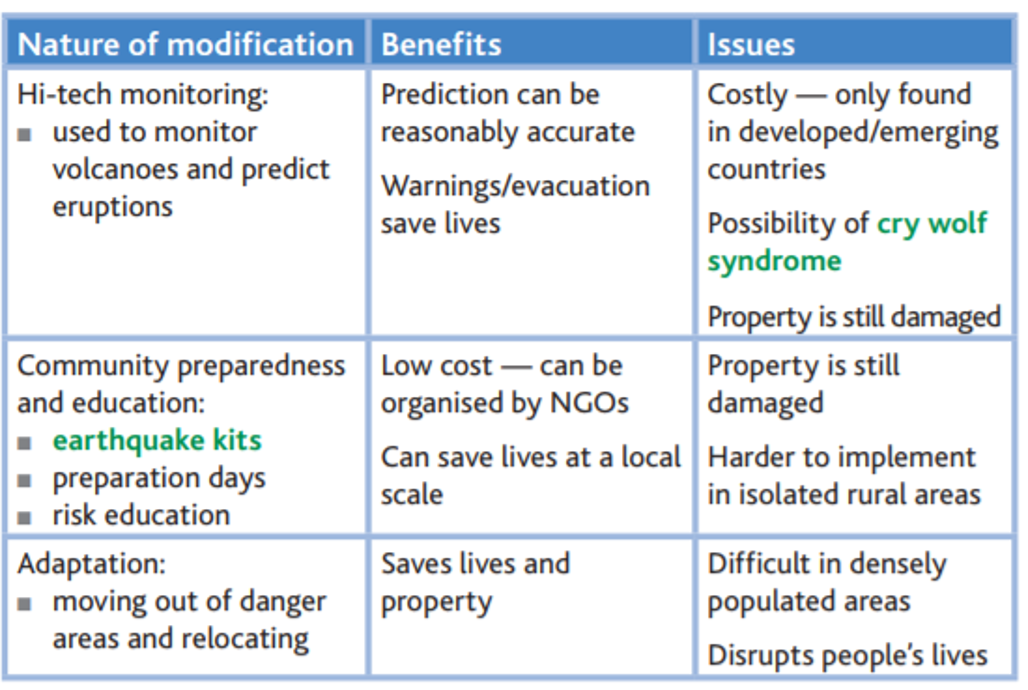
1.9a Examples of modifying the event strategies
Land use zoning- prevention of buildings on low-lying coasts (tsunamis), avoiding areas close to volcanoes, avoiding areas where liquefaction is likely
Benefits- low cost, relocates people from areas of high-risk
issues- prevents economic development in some coastal areas, requires strict enforcement
Aseismic buildings- cross-bracing, using counterweights, deep foundations e.g. Hawaii timber houses> can be moved easily
Benefits- protects people and property, financially possible in the developed world, basic design can be replicated in the developing world.
issues- high costs for tall buildings, older buildings and homes for people on low incomes are too difficult to protect
Tsunami defences- building sea walls and breakwaters
benefits- reduces damage, provides a sense of security
issues- can be overtopped, very high cost, unsightly
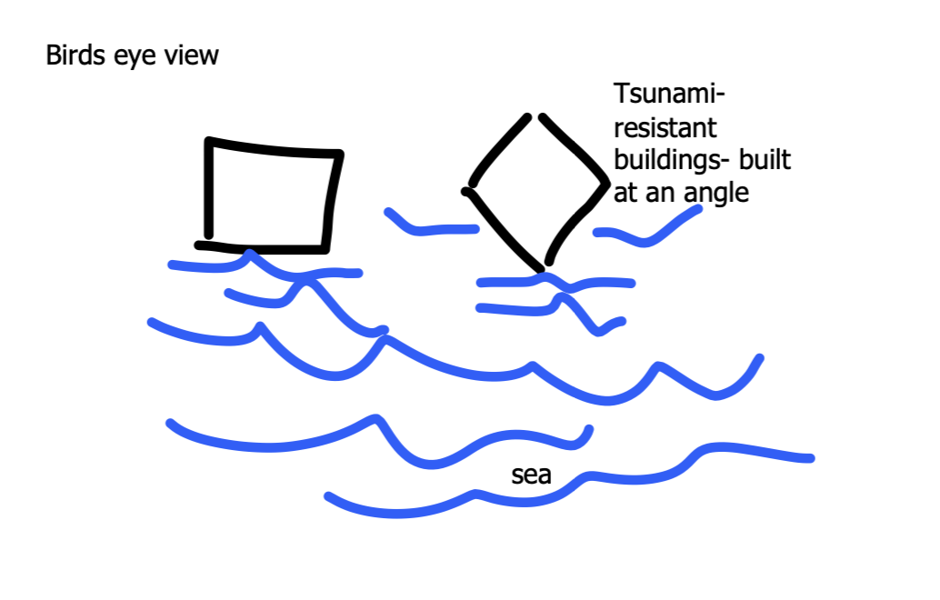
Tsunami resistant designs
Mangrove swamp and coral reef protection
Build buildings at a higher level far from the shoreline and not at the top of a smooth shallow beach
If buildings are high, then water can flow under them
It helps if the building is not square on to the wave front. If diagonal, the wave hits the pointed corner first and is diverted around the sides. Pressure is much reduced. Buildings should not be close together in a way that makes a wider dam. If roads have buildings all along both sides, the water is funnelled along the roadway, accumulating debris as it goes, and with no reduction in height or destructive force. It is much better if gaps are left between buildings out through which the water can dissipate. If the soil is sandy, then the footings should be deep and bracing should go right down to the feet. Light soil will also be protected from erosion by tarmac or concrete surfacing, which should go right underneath the floor if it is raised.
Timber buildings are much liked in earthquake areas because they are light and thus reduce earthquake effects. But they are the worst possible choice in tsunami-prone areas; like the ships, they float, and there is nothing to hold them down. The wood becomes weapons which destroy buildings and lives.
Lava diversion- channels, water cooling e.g. 1973 Eldfell, 2024 Blue Lagoon, 1983 Etna
Benefits- diverts lava away from people and buildings, relatively low-cost
issues- only works for basaltic lava, not feasible for majority of explosive volcanoes
1.9b Cry wolf syndrome
occurs when predictions prove to be wrong so that people are less likely to believe the next prediction and warning and therefore fail to evacuate
e.g. l’Aquila, Italy 2009- Scientists charged with manslaughter for failure to warn people
1.9b Earthquake kits
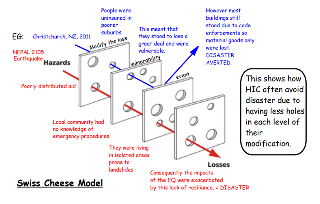
Reason’s Swiss Cheese Model
really good in a conclusion
1.9b Modify the vulnerability and resilience strategies
HI tech
e.g. Sakurajima Japan
Community
e.g. 1997 Montserrat
1st September every year in Japan- Disaster Preparedness Day
Shakes out 3rd Thursday of October in California
1.9c Modify the loss strategies
What is a volcano?
A landform that develops around a weakness in the Earth’s crust from which molten magma, volcanic rock, and gases are ejected or extruded.
1.5a What is the volcanic explosivity index (VEI) ?
the volcanic explosivity index (VEI) is a relative measure of the explosiveness of volcanic eruptions. It is a composite index that combines eruption height, volume of material erupted, and duration of eruption.
Events of VEI 6 and over are very rare e.g. Tambora 1815, Yellowstone Caldera 600,000 years ago
1-8 (no modern human has ever experienced a VEI of 8- 1815 most recently 7.6km Mount Tambora, Indonesia- ash cloud circulated whole globe- 3 years of darkness, crop failure, pyroclastic flows killed people immediately)
Hunga-Tonga 2022- VEI 6
0-3/4 associated with shield volcanoes and basaltic eruptions at constructive plate margins and mid-plate hotspots Eyjafjallajokull VEI 3
Subduction zones have a high VEI of 3 or 4 because their magma has a high gas and silica content.
4-7 occur at destructive plate margins, erupting high viscosity, high gas, high silica, andesitic/rhyolitic magma, Merapi 2010 VEI 4
The higher explosivity VEIs are less common because the magma chamber has to fill up before eruption e.g. Yellowstone
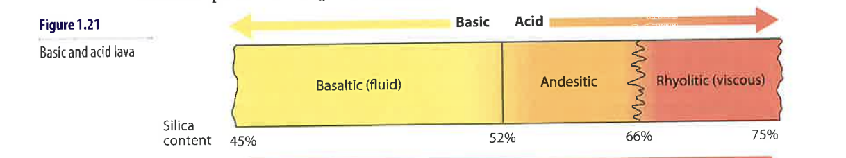
1.3b What are the three types of magma?

Basaltic magma
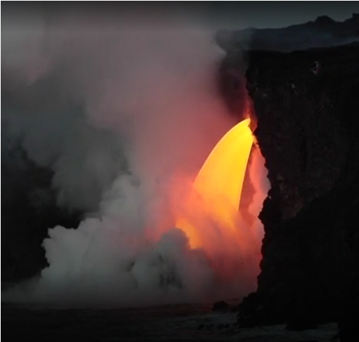
has low viscosity is hot 1200 celsius degrees and runny like warm treacle, has a lower silica content, takes a longer time to cool and solidify so flows considerable distances as rivers of molten rock, produces extensive but gently sloping landforms- shield volcanoes- non violent eruptions, eruptions are frequent but relatively gentle, lave and steam ejected, found at constructive plate margins where magma rises from the mantle, e.g. fissures along the Mid-Atlantic Ridge (Heimaey); over hot spots (Mauna Loa, Hawaii)
low vei
Andesitic magma/ acid lava
viscous, les shot 800, flows more slowly and for shorter distances
larger silica content
soon cools and solidifies, flowing very short distances, produces steep sided, more localised features, eruptions are less frequent but violent due to the build up of gases
as rocks, gases, steam and lava ejected
found at destructive margins where oceanic crust is destroyed (subjected), melts and rises, e.g. subduction zones Mount St Helens and island arcs Mt Pelee
stratovolcanoes- Piantubo 1991, Phillipines
plume penetrates into the the troposphere
get pyroclastic flows on the side and tephra fallout
Rhyolitic magma
high gas content
catastrophic eruptions
high viscosity, which traps the gas and builds pressure
high vei
high silica content
1.3b What is a lateral blast?
Lateral eruptions are caused by the outward expansion of flanks due to rising magma. Breaking occurs at the flanks of volcanoes making it easier for magma to flow outward. As magma is pushed upward towards the volcano it diverges towards the flanks before it has a chance to erupt from the crater. These are super difficult to predict. Can also get a pyroclastic flow happening. E.g. Mount St Helens, Mt Pelee.
1.3b How does silica content affect viscosity?
The higher the lava’s silica content, the higher its viscosity.
1.3b Two types of volcanoes?
shield and composite/cone
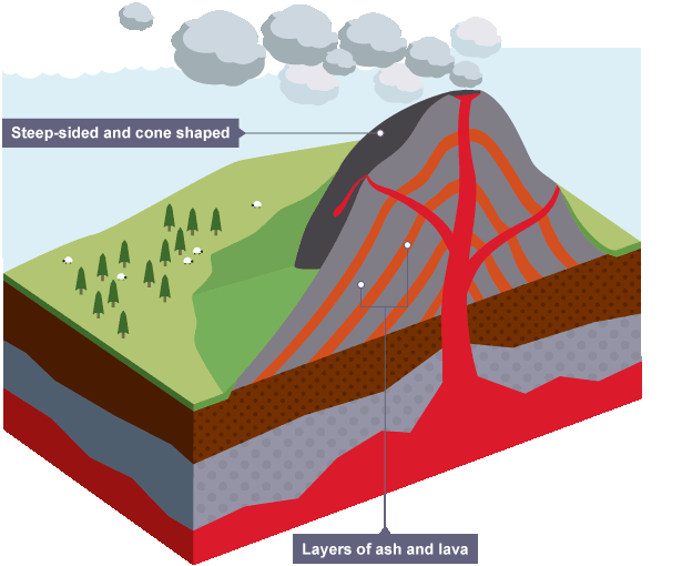
1.3b Composite/cone volcano
examples
plate boundary
type of magma
type of eruption
material ejected
frequency of eruption
Mt St Helens and Pinatubo
Andesitic magma, which is lower in temperature, has more silica and a lot of dissolved gases and is more likely to explode when it reaches the surface. or andesitic
Located at destructive plate margins
Acidic lava, which is very viscous (sticky).
Steep sides as the lava doesn't flow very far before it solidifies.
Alternate layers of ash and lava. For this reason, they're also known as stratovolcanoes as Strato means layers.
Violent eruptions- lava shatters into pieces
lava bombs, ash and dust
Longer periods between eruptions. from time to time-long dormant periods
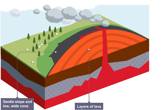
1.3b Shield volcano
examples
plate boundary
type of magma
type of eruption
material ejected
frequency of eruption
Shield volcanoes are found on divergent/constructive plate boundaries, where two plates move away from one another. Shield volcanoes have the following characteristics:
Mauna Loa, Hawaii, Eyjafallajokull, Iceland
basaltic magma, which is high in temperature, very low on silica and with low gas content - this type of magma produces fluid lava with very little explosive activity
basic lava, which is non-acidic and very runny
gentle sides as the lava flows for long distances before it solidifies
constructive plate margins
no layers, as the volcano just consists of lava
less violent eruptions- effusive- gas escapes easily
mainly lava rather than other materials.
shorter periods between eruptions
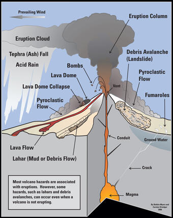
1.3b Volcanic hazards: primary and secondary + case studies
Lava flows and lava domes
Lava flows are flows of magma extruded onto the surface of a volcano. It is rare for lava to cause the direct loss of life as it flows very slowly- people can evacuate, e.g. The Blue Lagoon 2024. The viscosity increases with silica content. Low-viscosity lava types can flow much further distances.
Lava domes form when high-viscosity lava is slowly erupted from a volcano. Due to the high viscosity of the lava, it cannot travel far from the vent and a dome of lava builds up. These lava domes are particularly hazardous as they tend to be unstable and can collapse, causing pyroclastic density currents.
Flood basalts: the result of a giant volcanic eruption or series of eruptions that covers large stretches of land or the ocean floor with basalt lava rare form of lava flow- our understanding of these is based on studies of past eruptions like the Deccan Traps in India. hey can have thicknesses up to a kilometre and release large amounts of gas; they can cause air pollution and even have an impact on the global climate. In 2014, the Holuhraun fissure eruption reached flood basalt size. It is now the largest flood basalt in Iceland since the Laki eruption in 1783–1784, which caused the deaths of about 20 per cent of the Icelandic population by environmental pollution and famine. It most likely also increased levels of mortality elsewhere in Europe, through air pollution by sulphur-bearing gas and aerosols.
Pyroclastic flows
Hot density currents consisting of mixtures of rock debris and gas that flow along the ground at high speed.
they move as a result of gravity
their extreme power and energy has been shown through some pyroclastic flows Defying Gravity and moving uphill.
They typically move at 110 km per hr or faster down the sides of volcanoes
Fountain collapse pyroclastic flows- can occur during explosive eruptive activity, where the mixture of gas and ash emitted from the volcano is too dense to rise buoyantly into the atmosphere. Instead, it collapses around the volcano
Dome collapse- pyroclastic flows- volcanoes that erupt very viscous lavas that form domes can also produce pyroclastic flows if the dome becomes unstable. pyroclastic flows are produced when large portions of the dome collapse and disintegrate
Temperatures may exceed 400ºC
For example, during the 1902 eruption of Mont Pelee in Martinique (West Indies), a pyroclastic flow (also known as a “nuee ardente”) demolished the coastal city of St. Pierre, killing nearly 30,000 inhabitants.
Lahars
snow and ice melt on top of the volcano, meltwater mixes with the ash, causing a mudflow
Eruptions cause static energy resulting in thunderstorms. The rain mixes with the ash Nevado del Ruiz, 1985
It is a Javanese word for a type of volcanic mudflow made up of volcanic debris and hot or cold water.
They move at speeds that range from less than 10kmph to up to tens of kilometres per hr.
As they flow down river valleys they can gather more and more loose material.
These can be viscous and non-viscous
Notable lahars include those at Mount Pinatubo in the Philippines and Nevado del Ruiz in Colombia, the latter of which killed more than 20,000 people in the Armero tragedy.
Jökulhlaup
an Icelandic word that is used to describe a glacial outburst flood- a sudden release of water from a lake that lies under or close to a glacier. yo-KOOL-lahp
Eyjafjallajökull in 2010
One of the triggers of a jökulhlaup could be the eruption of a volcano situated beneath a glacier that melts overlying ice or weakens a dam made of glacial moraine sediments. The sudden removal of the lake dam releases a huge volume of water to produce a megaflood that can wash away roads and bridges.
landslides and debris avalanches
can be triggered as the result of a volcanic explosion or dome collapse, especially when heavy rainfall is common
Debris avalanches tend to become channelled into valleys
it is difficult to reduce the impact of debris avalanches because they can occur without warning- even on dormant volcanoes!
once initiated it is almost impossible to evacuate areas in the paths of debris avalanches because of the great speed with which they travel.
On Boxing Day 1997, a large volcanic explosion caused the partial collapse of the Soufrière Hills Volcano, Montserrat, triggering a debris avalanche. About 60 million m3 of dome and crater wall travelled to the south as a debris avalanche with other pyroclastic material. The villages of St Patrick’s and Morris were swept away in less than 30 minutes.
tephra/ashfall
tephra is an umbrella term for all erupted clasts regardless of size
Ash describes particles of less than 2mm in size
During an eruption most tephra falls to the ground around the volcano- this affects nearby buildings and travel.
The loading of tephra on plants can lead to branches being stripped or plants being buried- this can have an impact on agriculture
volcanic ash is easily transported by winds to hundreds of thousands of kilometres away. Sometimes it reaches the stratosphere.
Ash is made up of small, sharp, angular fragments of glass and other volcanic rock; due to its abrasive nature, volcanic ash can cause damage to aircraft.
18 May 1980, Mount St. Helens
spreading five hundred million tons of tephra ash
release of gas
Various gases can be emitted by active volcanoes before, during or after an eruptive event and can cause various health hazards locally, but also have the potential to affect the climate globally.
The main 5 gases posing a threat to health are: carbon dioxide, hydrogen chloride, hydrogen fluoride and sulphide and sulphur dioxide
People are exposed to harmful volcanic gases by breathing them in or through contact with eyes and skin. These are very hazardous because they cannot be seen, they are denser than ambient air and, therefore, can be ponded in depressions around an active volcano. Sulphur gases convert to sulphate aerosols which if they reach the stratosphere may remain there for years, causing short-term climate change.
The 1991 eruption of Mt. Pinatubo is thought to have injected more than 250 megatons of gas into the upper atmosphere on a single day
tsunamis
means harbour wave- Japanese word
can form in relation to many things
volcanoes can cause tsunamis even tho they are less common
Tsunamis have caused the most fatalities associated with volcanic eruptions in historical times
Tsunamis form when water is placed- on volcanoes- this can occur via several mechanisms e.g. a submarine eruption, collapse of part of a volcanic edifice, entrance of lahars or pyroclastic density currents into the surrounding water.
An example of such an event is the 1883 eruption of Krakatau, Indonesia. While there is still some discussion as to the exact source of the tsunamis, the eruption produced large pyroclastic flows and led to collapse of the volcano. Numerous tsunamis were produced, with the most devastating resulting in more than 36 000 deaths.
In December 2018, approximately half of the volcano collapsed into the surrounding seas, forming a tsunami that affected much of the coast along the Sunda Straits and causing the deaths of more than 400 people.
1.9a Modify the event (protection)
• Hazard-resistant designs (timber houses in Hawaii) Ash fallout has a large impact and design can help reduce this- this prevents the buildup of ash on roofs.
Building design can’t really control the stronger hazards like pyroclastic flows
•Environmental control, e.g. lahar barriers- significant dangers are posed by the secondary effects of lahars- in Indonesia some villages have artificial mounds to enable villagers to escape higher ground, although adequate warning is needed if this is to be effective because of their rapid onset
draining crater lakes (Kelud, Java)- a tunnel through the crater wall of Kelut volcano, Java- has also been tried to drain the crater lake and reduce the risk of lahars forming. A notch was built through the crater wall of Mount Pinatubo to drain a lake which developed in the years after its big eruption.
artificial mounds (Hilo, Hawaii)- proposed to protect Hilo, Hawaii from future lava flows. In Indonesia, some villages have these to enable villagers to escape to higher ground. ). After the 2002 Nyiragongo eruption in the DRC, artificial mounds of earth were used to elevate the land.
explosives (1983 Etna) - Explosives used with some success in 1983 eruption of Etna when 30% of slow moving lava was diverted from its course. The USGS scientists and US military worked in partnership with the Italian government to execute this
water spray (1973 Eldfell) - Sea water sprays were successfully used to cool lava flows in 1973 eruption of Eldfell, Iceland to protect harbour. They successfully protected the harbour of Vestmannaeyjar.
•Land-use zoning: avoiding areas close to volcanoes
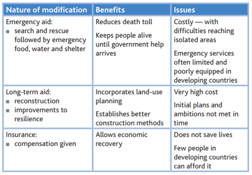
1.9c Modify the loss (response)
1. Aid: Technical aid supplied by MEDC for monitoring equipment. Financial aid used during and after event. Government must be willing to ask for and accept from others. . Aid for volcanic hazards comes in two forms: technical aid for monitoring and forecasting and financial / goods aid. Technical aid is usually supplied by MEDC experienced in volcanic eruptions – e.g. the USGS helped with Pinatubo. This involves the use of high cost monitoring equipment and expertise to try to forecast events. Financial and other aid is used as a strategy during and after an eruption. This may need to occur over a long period compared with other natural hazards, since eruptions may continue for months at varying levels of activity. For aid to be an effective management approach governments must be willing to ask for and receive help from other nations. Indonesia has much experience with volcanic eruptions and has developed a high level of hazard mitigation within its financial resources. This involves monitoring of volcanoes and planning for how aid will be used. The Tungurahua volcano eruption in Ecuador in 2006 Japan, Spain, Switzerland, China, Britain, Bolivia, Peru and the United States have jointly provided 1.4 million U.S. dollars for the volcano victims.
2. Insurance: Insurance companies need to identify key areas of risk and hazards in order to secure their business. Indonesia developed high level of hazard mitigation. Monitors volcanoes and plans how aid will be used. In richer areas, people are urged to take out insurance to cover their losses, the only problem being that for individuals, this is very expensive. In the Kobe earthquake in Japan in 1995, for example, only seven per cent of the people were covered by earthquake insurance.
1.9b Modify the vulnerability (prediction/preparation)
1. Community preparedness - Most volcanic events are preceded by clear warnings of activity from the volcano. If the community at risk is prepared in advance, many lives can be saved. Evacuation is the most important method of hazard management used today. Evacuation of the area at risk can save lives, but advance preparation and management structures to organise the evacuation, temporary housing, food etc. are needed.
- Evacuations: The length of time of the evacuation may be long term: e.g. 5000 residents of Montserrat were evacuated three times between December 995 and August 1996 for periods of up to three months, to avoid pyroclastic flows and ashfalls. By November 1996, the disruption was thought to last another eighteen months. The scale of evacuations can be huge – in 1995 volcanologists and civil defence officials drew up an emergency plan for the 600,00 people at risk from an eruption of Vesuvius. The operation is large scale and involves removing people to safety by ship. If the people involved panicked the plan would be useless. People need to be clear of the risk and how to behave during an event.
Evacuations have been very successful in recent times and are the most common hazard-management strategy. Pinatubo had the evacuation of 250,000 people but 800 still died. Nevado del Ruiz was a disaster with 23000 deaths as the Colombian government did not have a policy in place for monitoring volcanoes and for disaster preparedness. Communications between scientists monitoring volcanoes and government officials must be clear, consistent and accurate. The eruption was expected, and scientists monitoring the activity had produced a hazard map. However, a lack of clear communication and indecision resulted in disaster. The Colombian government had more serious and immediate problems – economic crisis, political instability and drug gangs (narcotic cartels) – to deal with. Hazard salience is important at the government level.
- Prediction and warning: Knowledge of volcanic processes is incomplete, but there have been great strides made in forecasting eruptions. Various physical processes can be monitored for changes which can signal an impending eruption. The record of past eruptions is also used to help determine what and where the risks are highest. At the present time, only 20% of volcanoes are being monitored. As might be expected this is mainly in MEDCs such as Japan and the USA which have the researchers, technology and cash to undertake these activities. Even in these areas records are not complete. An example of a closely monitored volcano is Sakurijama, in South Kyushu, Japan.
In countries lacking the financial and technological resources for such monitoring, more basic but still useful techniques have been used. In the Philippines, local people are trained to look out for early-warning signs such as sulphur odours, steam releases and crater glow.
Once scientists have detected signs of activity the events must be interpreted to produce a hazard assessment and prediction of what will happen. Only then can government officials and other agencies such as the news media be informed and warnings and evacuation be introduced to the general public. This is still difficult to do accurately, and interpretations may differ among the scientists involved. This was to some extent the case with Nevado del Ruiz and led to the delay of the warning to the Colombian government, although the hazard map eventually produced was very accurate. The ashfalls were confined to the marked areas and the valleys like the Lagunillas (leading to Armero town) were affected by lahars as predicted.
Volcanoes often show signs if impending eruption and monitoring can be increased as the volcano becomes active.
2. Volcanic hazard mapping: Places with less money, look for signs instead e.g. steam releases. Do hazard assessment and predict what will happen. However interpretations may differ, causing delay etc.
3. Land use planning: Land use can be planned once there is an agreed volcanic hazards map to use as a basis. It is still difficult to predict in the long term the timing and scale of future eruptions. Many LICs do not possess the maps and past records necessary to produce accurate hazard assessments, but where they do exist they can be used to plan land-uses which avoid high risk areas or would result in reduced economic losses. These need to be enforced through legislation and education of the public.
1.7c What opportunities did the eruption of Eyjafjallajokull bring? (positives)
Despite the problems caused by the eruption of Eyjafjallajokull, the eruption brought several benefits. According to the Environmental Transport Association, the grounding of European flights prevented some 2.8 million tonnes of carbon dioxide into the atmosphere (according to the Environmental Transport Association).
As passengers looked for other ways to travel than flying, many different transport companies benefited. There was a considerable increase in passenger numbers on Eurostar. It saw a rise of nearly a third, with 50,000 extra passengers travelling on their trains.
Ash from the Eyjafjallajökull volcano deposited dissolved iron into the North Atlantic, triggering a plankton bloom, driving an increase in biological productivity.
Following the negative publicity of the eruption, the Icelandic government launched a campaign to promote tourism. Inspired by Iceland was established with the strategic intent of depicting the country’s beauty, the friendliness of its people and the fact that it was very much open for business. As a result, tourist numbers increased significantly
1.7c Why do people live in a hazardous area?
emotional attachment
always lived there
roots
ignorance of the risks/underestimation
lack of alternatives
economic opportunities like tourism, farming, mining, geothermal power
Seismic Gap Theory
'Seismic gaps', i.e. areas that have not experienced an earthquake for some time and are 'overdue' can point to areas of high risk
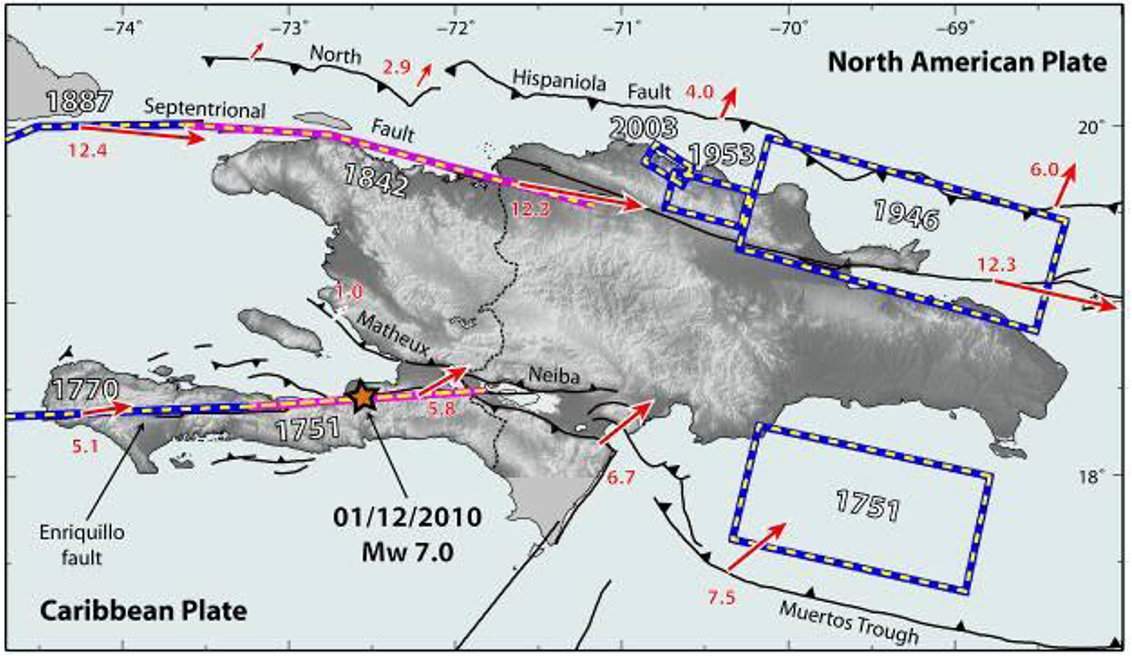
1.4a Definitions of a disaster
-Situation or event, which overwhelms local capacity, necessitating a request to national or international level for external assistance
An unforeseen and often sudden event that causes great damage, destruction and human suffering. Though often caused by nature, disasters can have human origins.
The International Disaster Database defines disasters as situations or events which overwhelm local capacity, necessitating a request for external assistance at the national or international level. Disasters are unforeseen and often sudden events that cause significant damage, destruction, and human suffering. To qualify as a disaster, it must have at least one of the following criteria:
• 10 fatalities;
• 100 affected people;
• a declaration of state of emergency;
• a call for international assistance
Disasters have to involve people and they occur in the intersection of people and hazards- as shown by the Deggs Model
1.4a Define a natural hazard
-Threatening event, or probability of occurrence of a potentially damaging phenomenon within a given time period and area.
-Without people it is just a natural event not a hazard, it needs the interaction of people to make it a hazard!
1.4a Define risk
Expected losses (of lives, persons injured, property damaged and economic activity disrupted) due to a particular hazard for a given area and reference period. Based on mathematical calculations, risk is the product of hazard and vulnerability.
1.4a Define vulnerability
Degree of loss (from 0% to 100%) resulting from a potential damaging phenomenon.
describes how susceptible a population or parts of a population are to the damage of hazards, notably “the characteristics of a person or group and their situation that influence their capacity to anticipate, cope with, resist and recover from the impact of a natural hazard.”(Wisner, Ben et al 2005, 11)
is determined by processes in the natural environment and by places, people and power.
tends to increase the lower the country’s economic development and socio-political stability because risks and vulnerability make the impact of natural hazards patterns worse.
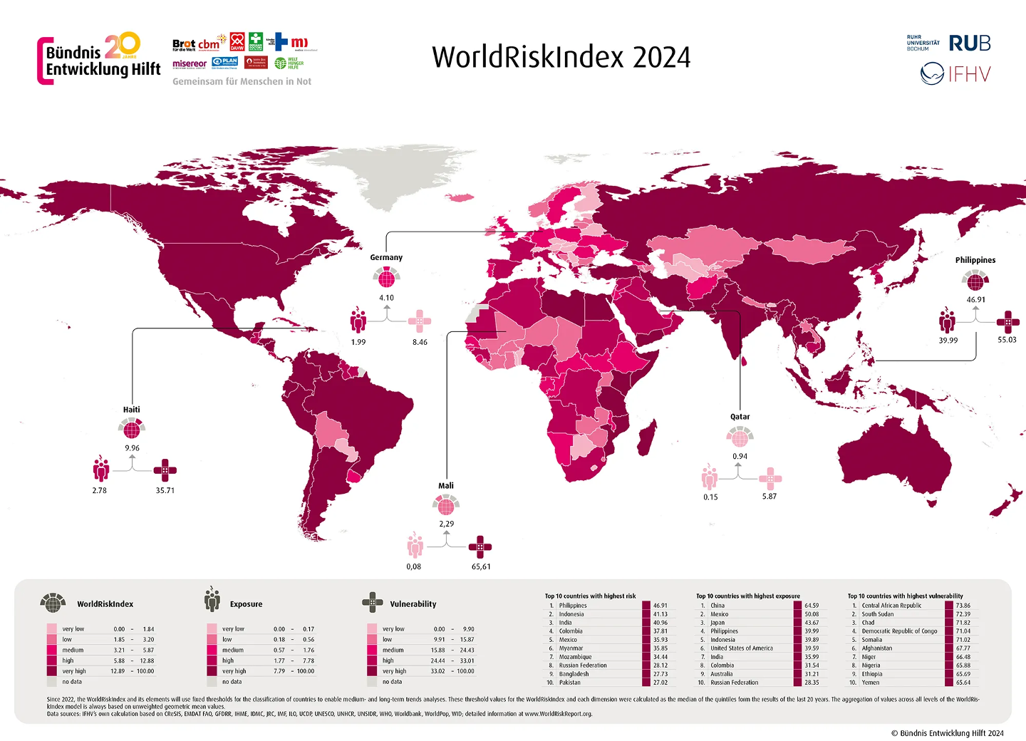
1.4a Hazard Risk Equation
people can be affected by natural disasters anywhere
However, the risk of disaster grows as global hazards and people’s vulnerability increases, while their capacity to cope decreases.
The disaster Risk Formula measures hazard vulnerability:
Disaster Risk = (natural hazard x vulnerability) / capacity of social system
Factors that decrease risk include:
effective warning and preparedness
better planning and building practices
development and insurance
Risk decreases if vulnerability decreases and coping capacity increases
1.4a Define coping capacity and resilience
Some communities have a high capacity to cope and a high resilience. This means they can reduce the chances of disaster occurring because:
they have emergency evacuation, rescue and relief systems in place
they react by helping each other, to reduce numbers affected
hazard-resistant design or land-use planning have reduced the numbers at risk
For these communities the threshold for disaster will be higher than for ones with low coping capacity.
Resilience is the ability of a community to cope with a hazard; some communities are better prepared than others so a hazard is less likely to become a disaster. It also includes the ability to return to normal following a disaster.
According to the UNISDR the resilience of a community in respect to potential hazard events is determined by the degree to which the community has the necessary resources and is capable of organising itself both prior to and during times of need.
Age affects resilience as children and old people suffer more. Around 66% of those over 60 live in less-developed regions, expected to rise to 79% by 2050.
The Disaster Risk and Age Index, compiled by the UNISDR highlights the trends of ageing populations and the acceleration of risk in a world that is increasingly exposed to a range of hazard types. It signals how age should be an important factor in understanding vulnerability and the coping capacity of older generations.
1.4a class-quake
The Guatemala earthquake 1976 made headlines as a ‘class-quake’, as it predominately affected the poor, excluded and vulnerable in slums while the urban middle and upper classes remained relatively unaffected.
In less developed countries:
A greater proportion of the population tends to be exposed to risk given population growth, land pressure and urbanisation. Moreover, the poorest tend to be disproportionately affected, often because they have migrated to hazard zones to search for work and may live in sub-standard and cramped conditions that collapse and crush them, the biggest cause of death.
The financial resources, technical capacity, level of education and ability to cope with hazardous events also tend to be lower.
The economies also tend to be driven by growth and tend to be less resilient in dealing with the disruption of the event.
There are also more likely to be other humanitarian crises as well as other issues like weak governance and infrastructure
1.8b The Hazard Management cycle (HMC)
The Hazard Management Cycle, sometimes also referred to as Disaster Management Cycle or Risk Management Cycle, is a systematic process that aims to reduce the impact of disasters by means of proactive planning and effective response, combined with learning and adaptation after the event.
Response
Immediate help in the form of rescue to save lives and aid to keep people alive, emergency shelter, food and water.
Recovery
Rebuilding infrastructure and services, rehabilitating injured (physically and mentally) people and their lives
The 'Recovery' Stage of the Hazard Management Cycle might be though of as the 'returning to normal' state. This can happen after a few months, but in some cases it takes years. The recovery stage depends upon:
the magnitude of the disaster - bigger means longer
development level - lower means longer, as poorer people are more severely affected
governance, because well governed places will divert resources more effectively to recovery efforts.
external help, i.e. aid and financing to help the recovery effort
Mitigation/prevention Acting to reduce the scale of the next disaster: land-use zoning, hazard-resistant buildings and infrastructure.
Preparedness
Community education and resilience building including how to act before, during and after a disaster, prediction, warning and evacuation technology and systems
(Repeat)
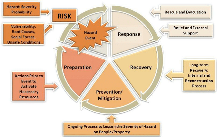
1.8c Park’s Model/ Disaster response curve
The importance of recovery can be seen on Park's Model: the disaster response curve, This well-known model provides a simple visual illustration of the impact of a disaster, and can be used to compare different events.
THIS MODEL ILLUSTRATES:
how quality of life is impacted by a hazardous event
how a range of management strategies can be used over time- from before to after the event
the importance of the roles of emergency relief agencies and rehabilitation
that different areas affected may have different response curves, depending on the level of preparedness and economic development of the place affected
It could be argued that the 2010 Port-au-Prince earthquake fits profile C because the devastation was still not 'fixed' by 2015 and incomes, health, housing and food supply remained worse than pre-disaster. Developed countries are more likely to correspond to profiles A or B, developing ones to C.
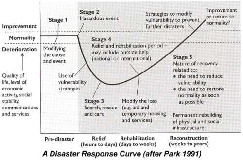
1.4b PAR Model- Pressure and release model
The PAR model suggests that the socio-economic context of a hazard is important. In poor, badly governed (root causes) places with rapid change and low capacity (dynamic pressures) and low coping capacity (unsafe conditions), disasters are likely.
It show how root causes, dynamic pressures and unsafe conditions combine with a natural hazard to create a disaster.
A disaster occurs when two forces (socioeconomic pressure and physical exposure interact or collide.
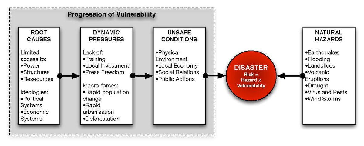
1.7a Tectonic disaster trends over time- Has number of disasters increased? Are they becoming more common?
earthquakes and volcanic events are not increasing, it would appear that the impacts are getting worse- we have more reports now so have more reliable data on disaster frequency.
Deggs Model- putting ourselves at risk by more people living in tectonically active areas
Kent Earthquake 2015- post-glacial rebound is reactivating old fault line
INGO
what are they?
what is their aim?
to what extent can we trust this data?
Centre for Research on the Epidemiology of Disasters- CRED; world leader into research and recording and tabulating all world disasters.
‘ Development and relief agencies have long recognised the crucial role played by data and info in mitigating the impacts of disasters on vulnerable populations. Crucial for governments, NGOs, poverty alleviation programmes and TNCS.