geo exam4
1/62
There's no tags or description
Looks like no tags are added yet.
Name | Mastery | Learn | Test | Matching | Spaced |
|---|
No study sessions yet.
63 Terms
What does crust type have to do with oceans?
Compared to continental crust (composed of a lot of granite), oceanic crust is more dense, thinner, and younger.
About how much of the Earth’s surface is covered by ocean
70.8%
is the ocean the deepest in the center
no
How do we describe water depth?
- bathymetry, variation of depth
How does the bathymetry vary as you move from land to the center of the ocean (passive vs. active margins)
PASSIVE MARGIN. It begins to get deeper and deeper but slowly (continental slope) has abyssal planes
ACTIVE MARGIN When you reach the shelf break is when it gets deep very quickly (continental shelf) has seamounts
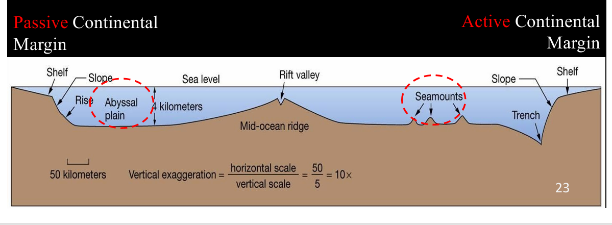
abyssal plain.
the lithosphere moves away from the mid-ocean ridge spreading centers it cools down and sinks. then is flat
seamounts
Hot-spot volcanoes (not plate boundary related) that do not rise above sea level

salinity
the measure of all the salts dissolved in water typically expressed in parts per thousand (PPT)
Average in ocean about 35
Why does salinity vary?
Water Temperature: warmer water can hold more salt. Like sugar and sweet tea
Addition of fresh water from river runoff, ground water, ice melt, direct rain. These are all fresher water that can bring the salinity down
Evaporation rate at oceans surface, taking away water leaving behind more salt
Solar Radiation Reaching Earth
Less solar radiation around north and south pole causing the water to be colder and then warmer around the equator due to more solar radiation
Current
well-defined stream of ocean water
Surface current:
are caused by interaction between wind and the surface of water. Only affects the upper few hundred meters of water.
Deep Currents:
are also influenced by wind due to zones of upwelling and downwelling
Upwelling- water being pushed to the left and up
Downwelling- water being pushed to the right and down
Coriolis effect
-– The deflection of objects, winds, and currents on the surface of the Earth owing to the planet’s rotation
Gyre
A large, circular flow pattern of ocean surface currents
Thermohaline circulation
– the rising and sinking of water driven by contrasts in water density which is due in turn to differences in temperature and salinity; this circulation involves both surface and deep water currents in the ocean
What causes ocean tides?
The larger tidal bulge is on the side closest to the moon and the smaller tidal bulge is on the other side so it develops as the earth spins relative to the two
Tidal reach (range)
– the elevation difference between sea level at high tide and low tide.
How does wave energy vary with water depth?
Energy decreases with depth
wave action
shear of wind blowing over the water surface
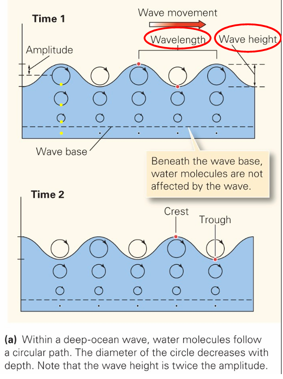
Wave morphology
• Crest - top of wave
• Trough - low area between waves.
• Wave base - the level (in depth) to which a wave affects the water
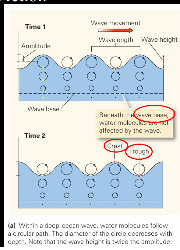
Wave parameters
• Wave height – distance between trough and crest
• Wavelength – horizontal distance between crests
Wave refraction
- the bending of the waves as they approach the shore at an angle (refraction basically equals bending).
Coast
– the belt of land bordering the sea
Longshore current
- moves parallel to the shore. Water current going the direction of the wind
Longshore drift
– the movement of sediment laterally along a beach; it occurs when waves wash up a beach diagonally
Groin
– a concrete or stone wall built perpendicular to a shoreline in order to prevent longshore drift from removing sand
water table
the boundary, approximately parallel to the Earth’s surface, that separates substrate in which groundwater fills the pores from substrate in which air fills the pore

Stream
– a ribbon of water that flows in a channel
Drainage network (basin)
– an array of interconnecting streams that together drain an area
There are 5 common types of drainage networks: dendritic, rectangular, trellis, radial, and parallel
what controls the type of network that will develop?
The geology, rock type
Drainage divide
a highland or ridge that separates one drainage basin (network) from another
Permanent streams
Water flows all year
• Bed/floor of channel is at or below the water table
• Humid or temperate climates
• Sufficient rainfall
• Low evaporation
• Discharge varies seasonally
Ephemeral Streams
Do not flow all year
• Bed/floor of channel is above the water table
• Dry climates
• Low rainfall
• High evaporation
• Flows mostly during rare flash floods
Laminar vs. Turbulent flow
Laminar occurs when a fluid flows in parallel layers, with no disruption between the layers
Turbulent a flow regime characterized by chaotic property changes
How do streams erode?
Scouring – running water removes loose fragments of sediment
Breaking and lifting – running water can break clasts of solid rock off the channel floor or walls
Abrasion – running water containing sand to gravel size particles that act like sandpaper and grinds away at the channel floor or walls
Dissolution
– running water dissolves soluble minerals as it passes and carries the minerals away in solution
Geologists refer to the total volume of sediment carried by a stream as its sediment load.
Bed load
– larger solid particles (sand, pebbles, or cobbles) that bounce or roll along stream floor
Suspended load
– small solid particles (silt or clay size) that swirl along in the water without settling to the floor of the channel
Stream competence
Stream capacity
Stream competence – refers to the maximum particle size a stream can carry
Stream capacity – refers to the total quantity of sediment it can carry (depends on competence and discharge)
What conditions (high/low energy, fast/slow water) propose sediment erosion/transportation and sediment deposition?
High energy (fast moving water) = sediment erosion/transportation
Low energy (slow moving water) = sediment deposition
Water flow rates (energy) decreases when?
a stream/river reaches a water body (ocean). When this happens, the larger clasts are deposited first, then medium size clasts (sand), and finally small clasts (silt/clay). Sorting occurs.
Delta
– a wedge of sediment formed at a river mouth when the running water of the stream enters standing water, the current slows, the stream loses competence, and sediment settles out
Stream gradient
– the slope of a stream’s channel in the downstream direction
Longitudinal profile
A cross-section image showing the variation in elevation along the length of a river
Base level
– The lowest elevation a stream channel’s floor can reach at a given locality
Ultimate base level is sea level (sea level can move up and down) A lake (natural or man-made) represents a local base level
A stream “tries” to erode down to base level (slow process)
Meander
– A snake-like curve along a stream’s course
Braided stream
– A sediment-choked stream consisting of entwined sub-channels.
channel
an elongate depression or trough through which a stream flows
Groundwater
– water that resides under the surface of the Earth, mostly in pores and cracks of rock or sediment
Karst landscape
– a region by underlain by caves in limestone bedrock; the collapse of the cave creates a landscape of sinkholes separated by higher topography; or of limestone spires separated by low areas
Porosity
– the total volume of empty space (pore space) in a material, usually expressed as a percentage, pores can become filled with water
Permeability
– the degree to which a material allows fluids to pass through it via an interconnected network of pores and spaces
Water table
– the boundary, approximately parallel to the Earth’s surface, that separates substrate in which groundwater fills the pores from substrate in which air fills the pores
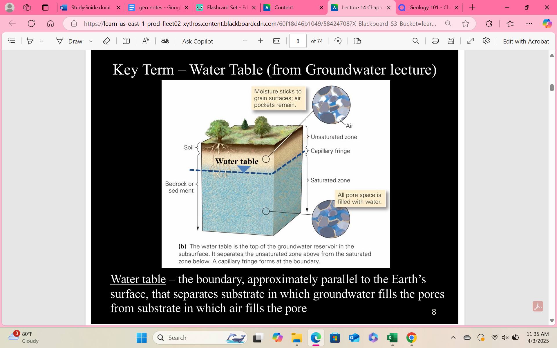
Unsaturated zone
– the region of the subsurface above the water table, pore space may contain some water and some air
Saturated zone
– the region below the water table where pore space is filled with water
Aquifer
– sediment or rock that transmits water easily (has high porosity and permeability)
Aquitard
– sediment or rock that does not transmit water easily and therefore retards (slows down/stops) the motion of water (typically has both low porosity and permeability)
- Confined aquifer – an aquifer that is separated from the Earth’s surface by an overlying aquitard
- Unconfined aquifer – an aquifer that intersects the surface of the Earth
Infiltrate
seep down into
Recharge area
Discharge area
Recharge area – a location where water enters the ground and infiltrates down to the water table
Discharge area – a location where groundwater flows back up to the surface, and may emerge at springs
Artesian well
– a well in which water rises on its own (due to angled bedrock and natural pressure within the system)
What happens when the water table intersects that Earth’s surface?
Water flows from the ground to the land surface. Water changes from groundwater to surface water.
Travertine
– A rock composed of crystalline calcium carbonate formed by chemical precipitation from groundwater that has seeped out at the ground surface.