Atmospheric Dynamics (Topic 4-6)
1/26
There's no tags or description
Looks like no tags are added yet.
Name | Mastery | Learn | Test | Matching | Spaced | Call with Kai |
|---|
No analytics yet
Send a link to your students to track their progress
27 Terms
What is the Rossby number and what do the variables in the equation mean? What conditions cause it to be large or small? How do you determine the relative importance of Coriolis Force and acceleration for different types of flow?
Ro = U/f0L; U - magnitude of the wind in m/s; f0 - Coriolis force; L - length scale in m
A large Rossby number is caused by a small L or a large U or both. A small Rossby number is caused by a large L or a small U or both.
if R0 is small (~0.1), then the acceleration is small compared to the CoF, thus indicating a mid-latitude weather systems where Coriolis is important. If R0 is large (~10), then the CoF is small compared to the acceleration and indicates small scale rotation like a tornado. If R0 is ~1 then both CoF and acceleration are equally important.
How should you apply scale analysis to atmospheric dynamic equations?
10% accuracy - keep largest terms (neglect terms one or more orders of magnitude smaller)
1% accuracy - keep largest terms and terms one order of magnitude smaller (neglect the rest)
0.1% accuracy - keep largest terms and terms two orders of magnitude smaller (neglect the rest)
How do you get the equation for geostrophic balance? What forces are balanced?
The geostrophic wind equation is derived from the horizontal momentum equations using 10% accuracy scale analysis.
Balance between CoF and PGF
How can you use geostrophic wind to explain westerly flows at upper levels in the mid-latitudes? And cyclonic and anti-cyclonic flow round L and H pressure systems in both hemispheres?
geostrophic wind always flow parallel to pressure or height contours with lower heights to the left of the wind in the NH (right of the wind in the SH). Since the tropics are warms and the polar regions are cold, upper level pressure slopes down towards the poles. The height gradient results in a poleward directed PGF (both hemispheres) and this a equator-ward CoF (geostrophic balance). To get this balance, upper level winds must be westerly.
PGF will always point inward towards a L, and in geostrophic balance, CoF must balance the PGF. In order to get this geostrophic balance wind will always flow CCW around a L in the NH (CCW around a high in the SH) and CW around a H in the NH (CW around a L in the SH)
What are the implications from the scale analysis of the vertical momentum equation for mid-latitude weather systems?
Results in hydrostatic balance with minimal error because PGF and g are 4 orders of magtiude greate than everything else.
What is the natural coordinate system?
a coordinate system in which one axis is always parallel to the horizontal wind (τ) and perpendicular to the left of the wind (η)
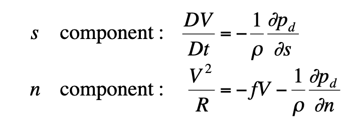
What is the physical interpretation of each of terms in the horizontal momentum equations in natural coordinates?
s - component:
LHS: changing speed of the air following the air parcel
RHS: pressure gradient force in the direction of the flow
n - component:
LHS: centripetal acceleration representing the turning of the wind
RHS: 1st Term — CoF ; 2nd Term — PGF perpendicular to the wind
Viscous force is neglected because it small for mid-latitude weather systems
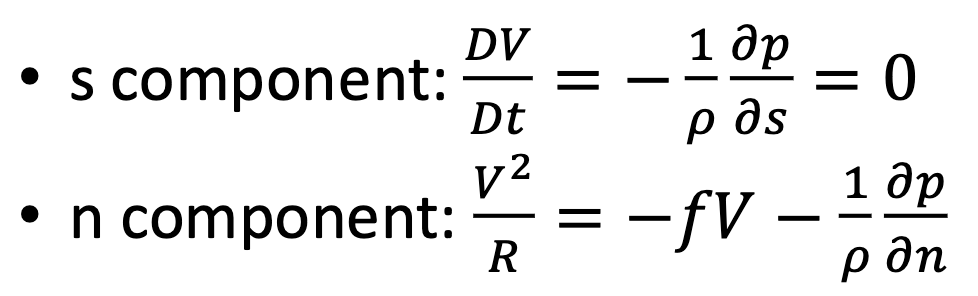
What is balanced flow?
Assumption that the atmosphere is in a purely horizontal, frictionless flow that is also steady state. Thus DV/Dt =0. This implies that there is no PGF in the direction of the flow, indicating that flow is parallel to isobars.
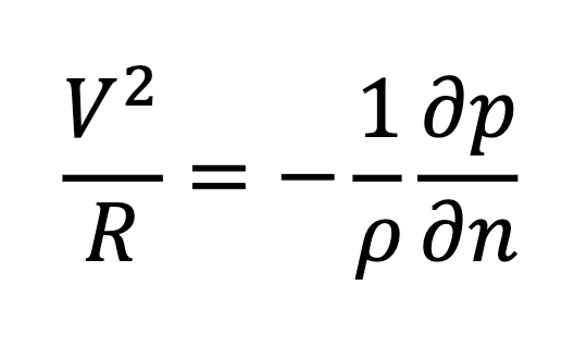
What is cyclostrophic flow?
Occurs if R0 is large (10 or more). Thus CoF is neglected.
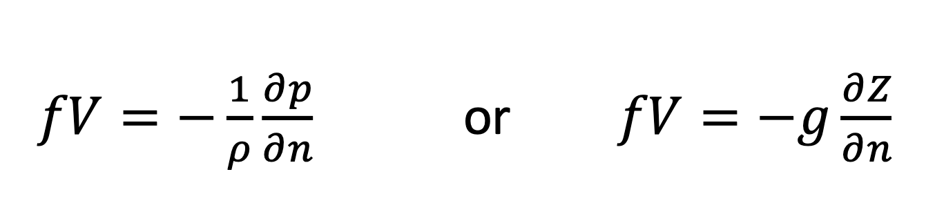
What is geostrophic flow?
Occurs if R0 is small (0.1 or less)
Geostrophic wind in non-divergent so it cannot explain pressure changes or vertical motion
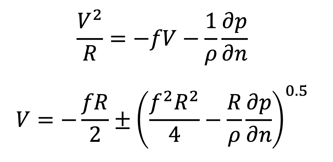
What is Gradient Wind? What do each of the terms mean? What forces are balance in the gradient wind equation
If R0 is around 1, neither CoF nor PGF can be neglected.
Of all the balanced flows in the chapter gradient wind is always the most accurate estimate of actual wind.
Centrifugal Acceleration = Coriolis force + PGF, so we can also think of the gradient wind as a three-way balance of centrifugal force (negative of centrifugal acceleration), CoF, and PGF
How and why do gradient wind speeds differ from geostrophic wind speeds in troughs and ridges?
Vgradient < Vgeostrophic for flow around a L in the NH
Vgradient > Vgeostrophic for flow around a H in the NH
The gradient wind has 3 components and the geostrophic wind had 2 components. So in order to understand why this occurs you need to understand the effect of centrifugal force.
The centrifugal force always points outward from the center of rotation. So if you are rotating around a L, your wind is CCW, the PGF points inwards and the CoF and CeF must balance the PGF. Since CeF and CoF are acting together the CoFgradient < CoFgeostropic so gradient wind speed does not need to be as fast as the geostrophic wind speed.
If the wind is rotating around a H, the PGF points outward along with the CeF. This means CoFgradient > CoFgeostropic so gradient wind will be stronger around a high.
What does the difference in speed of geostrophic wind and gradient wind tell us about the flow in between troughs and ridges?
*IMPORTANT ASSUMPTION: ASSUME GRADIENT WIND ~= ACTUAL WIND
Trough to Ridge (Low to High): The gradient (actual) wind speeds up and starts to move faster than the geostrophic wind so there must be divergence
Ridge to Trough (High to Low): The gradient (actual) wind slows and and starts to move slower than the geostrophic wind so there must be convergence
What is a-geostrophic wind? How can we estimate a-geostrophic wind using balanced wind approximations?
difference between the actual wind and geostrophic wind vectors
Under the assumption that gradient wind = actual wind,
Va-geostrophic = Vgradient - Vgeostrophic
Based on the difference between gradient and geostrophic wind in troughs and ridges, what is the direction of the a geostrophic wind in troughs and ridges?
Trough:
Vgradient < Vgeostropic
Vgradient — Vgeostropic = (-)
A-geostropic wind opposes flow
Ridge:
Vgradient > Vgeostropic
Vgradient — Vgeostropic = (+)
A-geostropic wind enhances flow
How does this explain why divergence occurs ahead (east) of troughs?
Inside a trough there is subgeostrophic flow because of the ageostrophic wind opposing the geostrophic wind → East of the trough wind starts to return to geostrophic flow (speeding up) → wind spread out → upper level divergence → convergence at surface → vertical motion → storm development (this explains why a Low east of a trough is going to strengthen because you have more divergence)
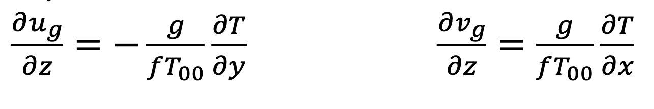
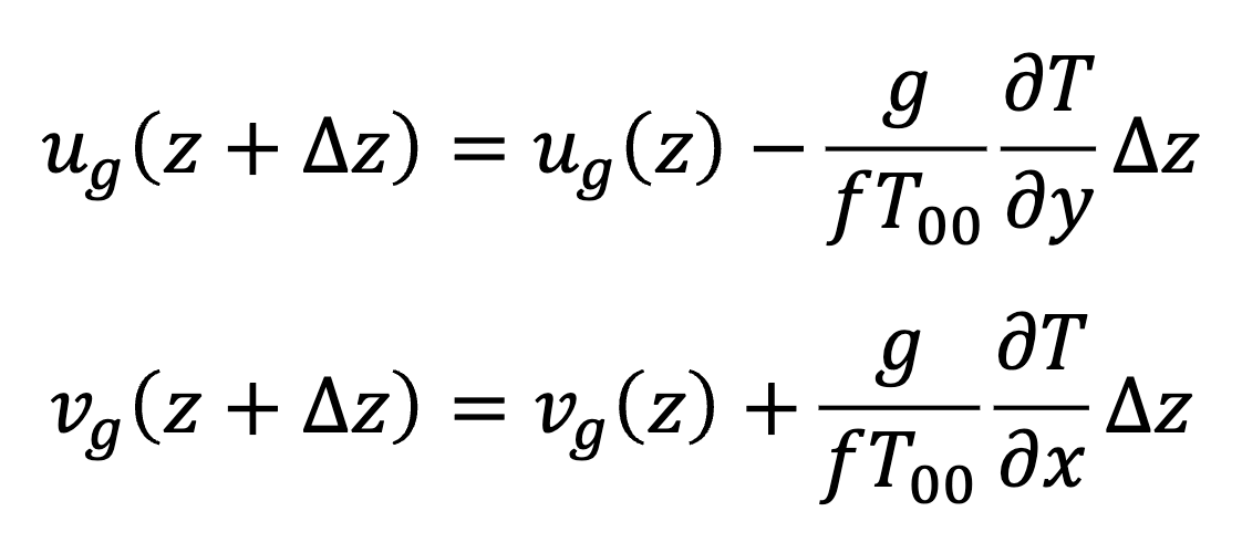
What is thermal wind? What is the relationship between horizontal temperature gradients and and vertical changes in geostrophic wind speed? Why does this relationship exist?
the variation in horizontal temperature gradients will change the height of upper level constant pressure surfaces and cause the geostrophic wind to vary with height
The left equation describes how a horizontal N/S temperature gradient will cause the zonal wind to vary with height.
The right equation describes how a horizontal E/W temperature gradient will cause the meridional wind to vary with height
Why is a westerly jet stream found near the tropopause in the mid-latitudes of both the NH and SH?
There is a N/S temperature gradients from the poles to the tropics (- dT/dy) → this causes the westerly geostrophic wind to increase with height → at the stratosphere temperature begins to decrease with height → therefore the jet stream sits near the tropopause.
wind starts to increase with height in stratosphere, stabalizing the wind and prevent further strengthening.
How do you estimate the thermal wind and lower and upper level geostrophic wind from surface and upper air weather maps?
How do you identify the presence of CAA and WAA based on changing wind direction with height?
CAA (Cold Air Advection) - the wind blows from a region of cooler temperatures to a region of warmer temperatures
If the geostrophic wind turns counterclockwise, CAA takes place (backing)
WAA (Warm Air Advection) - the wind blows from a region of warmer temperatures to a region of colder temperatures
If the geostrophic wind turns clockwise, WAA takes place (veering)
opposite in the southern hemisphere
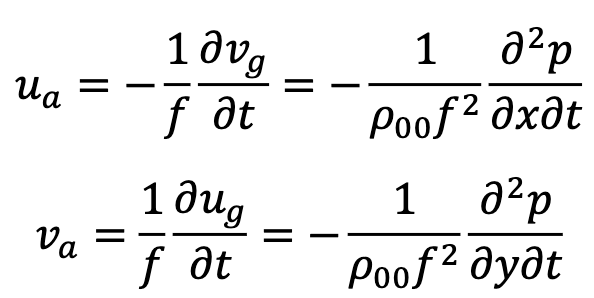
What do the quasi-geostrophic momentum equations represent physically?
Quasi-Geostrophic Flow - a flow in which a small departure from geostrophic flow occurs
Left side of the left equation - horizontal change in the geostrophic wind following the geostrophic motion
Right side of the left equation - a) change in geostrophic wind at a fixed point b) advection of horizontal geostrophic wind over a fixed point
the ageostrophic wind is equal to 1/f time DgDug/Dt
What is the relationship between the ageostrophic wind and the acceleration of the geostrophic wind?
Ageostrophic wind accounts for imbalances in the geostrophic wind
Since geostrophic wind is non-divergent, the horizontal convergence of ageostrophic wind is responsible for vertical divergence
What is isallobaric wind? What does the equation for isallobaric wind represent physically?
How can you estimate the direction of the isallobaric wind and the advective component of the ageostrophic wind on weather maps? How can you use this to estimate the acceleration of the geostrophic wind?
How is ageostrophic wind associated with jet streaks? What does this mean for where convergence and divergence, rising and falling pressure, and rising and sinking motion will occur relative to the jet streak?
Where are there areas of convergence and divergence relative to troughs and ridges, jet streaks, and the isallobaric winds? What do these areas mean for pressure changes and vertical motion?
How does the atmosphere respond to a situation when the flow is out of geostrophic balance?