Sed Strat exam 2
1/118
There's no tags or description
Looks like no tags are added yet.
Name | Mastery | Learn | Test | Matching | Spaced | Call with Kai |
|---|
No analytics yet
Send a link to your students to track their progress
119 Terms
Terrestrial: alluvial fans
High energy (periodic), flashy environment
- Coarse sand- to boulder-sized clasts (angular to rounded)
Typical in arid deserts
(immature)
- Requires continued uplift and erosion of highlands
Braided stream
No fines (too energetic)
- Cross-bedding, imbrication
Reverse grading (debris flow)
- Often dry, stream beds
fill after water recedes
Braided: upper plane bed
Channel walls absent (wide)
- Higher energy (competence)
- Higher gradient
- Gravel and sand
Meandering: lower plane bed
- Channelized
- Lower energy
- Muds and suspended
load sedimentation
- Lateral erosion and
deposition
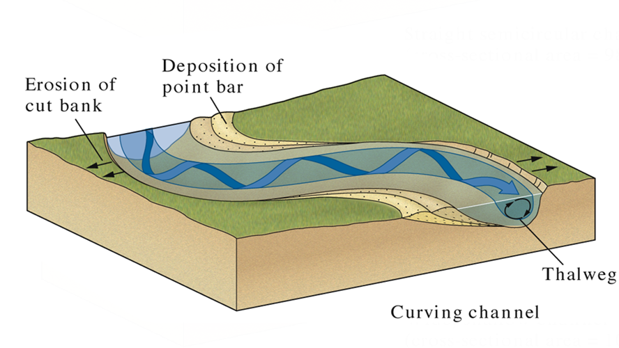
Terrestrial: fluvial - meandering
Streamflow is slower and deeper – sets up spiral flow
Stream avulsion
high flow causes meander to breach its course, flowing on another part of floodplain
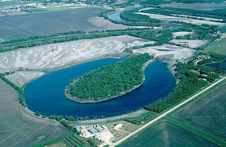
Point bar
accretes laterally, channel lag is buried by finer material (planar laminations: dunes and ripples),
- finally mud (if abandoned)
Levees and crevasse splays
Natural levees form on banks of streams to confine channel
During high flow, levee will breach to form a crevasse splay (x-bdd of bank sediment as water floods floodplain)
Capped by a coating of mud (suspension load) as waters recede
(red shale, mudcracks, soils, organics and root traces)
Marine: Longshore drift
The transport of sediment sub-parallel to the shoreline, mainly in the surf and swash zone.
Peritidal coastal environments
Not river (sed) dominated
Marshy at high tide, emergent at low tide
Minimal relief; shows reworking by tides, no progradation, barrier islands formed by longshore drift
Freshwater and saltwater mix here (brackish)
Shoreface (or nearshore)
Wave dominated; susceptible to erosion (low preservation)
- Lower: fine sand (& mud), may be planar lam. ± bioturbation
- Middle: accumulates longshore bars due to backwash of breakers (med. sand, well sorted, shells , x-bdd)
- Upper: affected by plunging waves, trough x-bdd
Backshore
Above high water line: topped by the berm
- Wind dominates waves (except storms), dune fields
- Lots of burrowing (crabs and roots)
- Washover fans may break through dune line during storms
Why is limestone important?
Fossiliferous (evolutionary history)
Porosity – reservoir for hydrocarbons
Porosity – reservoir for water (aquifers)
Cement, concrete, building stone
Chemical records for ancient environments
Responsible for our current atmosphere
Carbonate sediments
Limited conditions where carbonate environments can form – (clear, warm, shallow, agitated seas)
Organism type depends on conditions
Carbonate precipitation
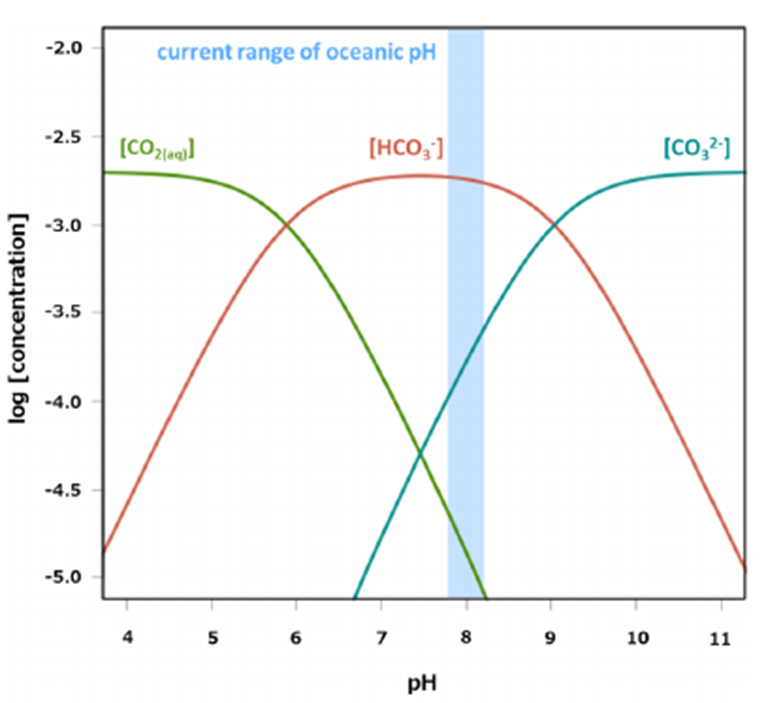
Bjerrum plot: concentrations of carbonate species under a range of pH values
Carbonate precipitation (Equation for carbonate formation in seawater)
Ca2+ + 2HCO3- ⇌ CaCO3 + H2O + CO2
Conditions that favor carbonate precipitation
All promote CO2 loss
Temperature increase
- Pressure release (degassing)
- Agitation (degassing)
- Organic activity
- Low clastic input (“poisons” CaCO3-producing critters)
- Light (photosynthesis)
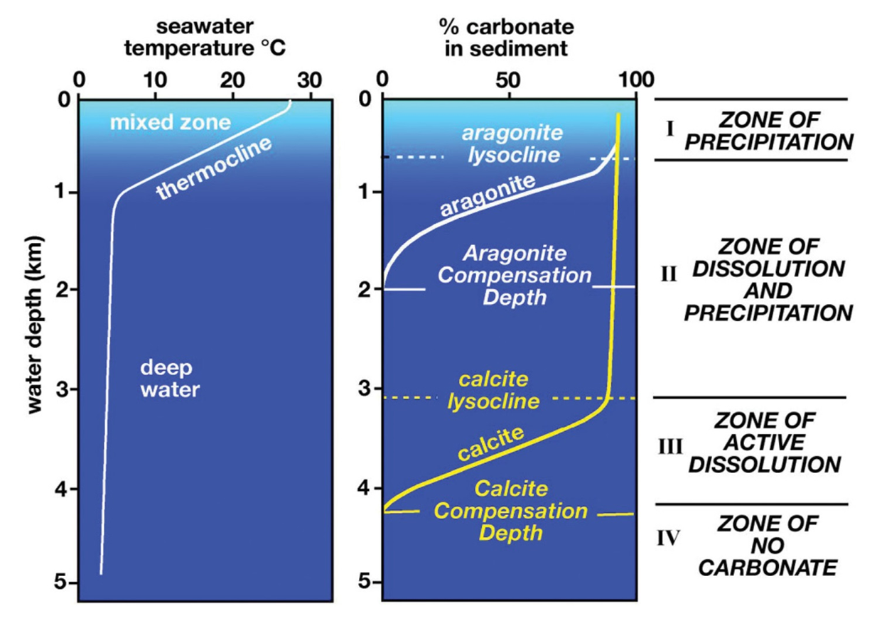
- Above the CCD
Carbonate compensation depth (CCD)
“Darwin’s Line”
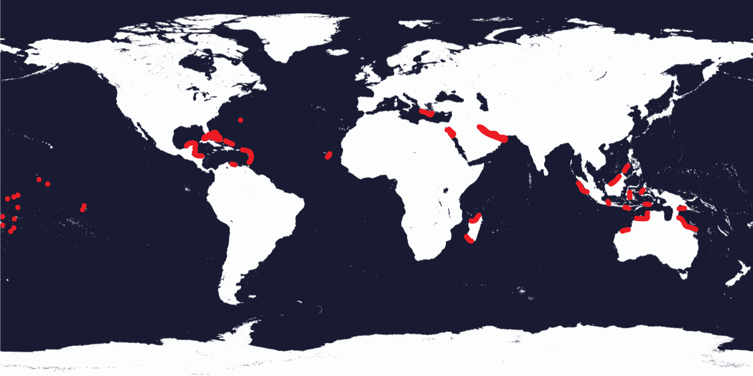
30ºN to 30ºS latitude: due to conditions in this range: shallow, warm, normal marine, little clastic input
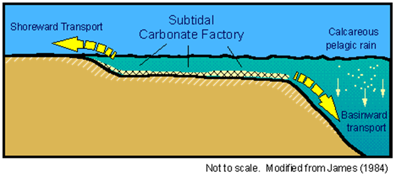
The Carbonate Factory: autocyclic vs allocyclic models
Carbonate grains: allochems
Fossil, ooids,Interclast,Pellets
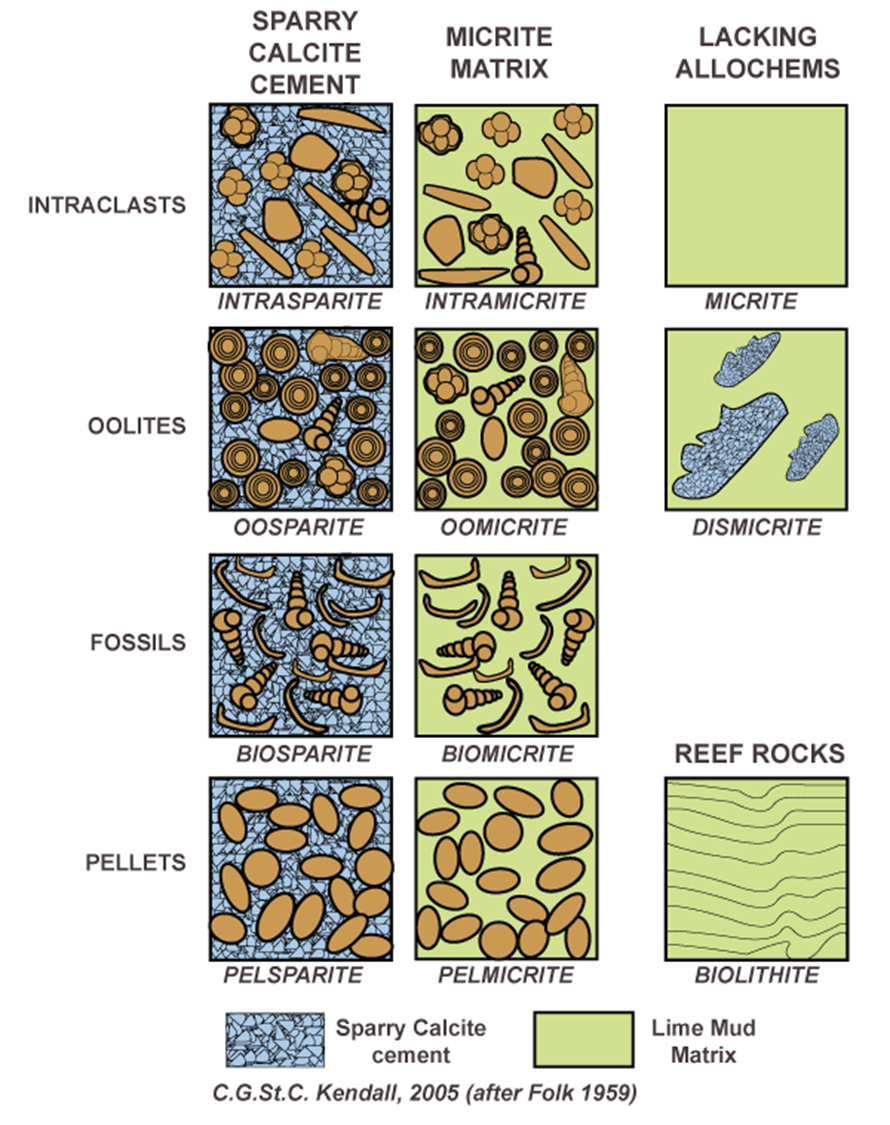
Carbonate classification
Folk scheme
Carbonate rocks are named using:
1)Main allochem type
●
2)Matrix or cement dominated
Carbonate mud = micrite
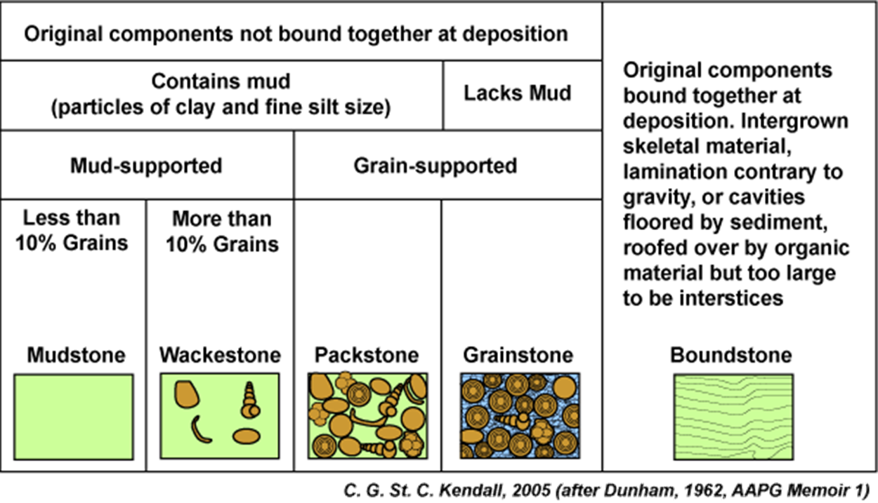
Carbonate classification Dunham scheme
1)Matrix or grain supported
2)Name modified based on allochem material
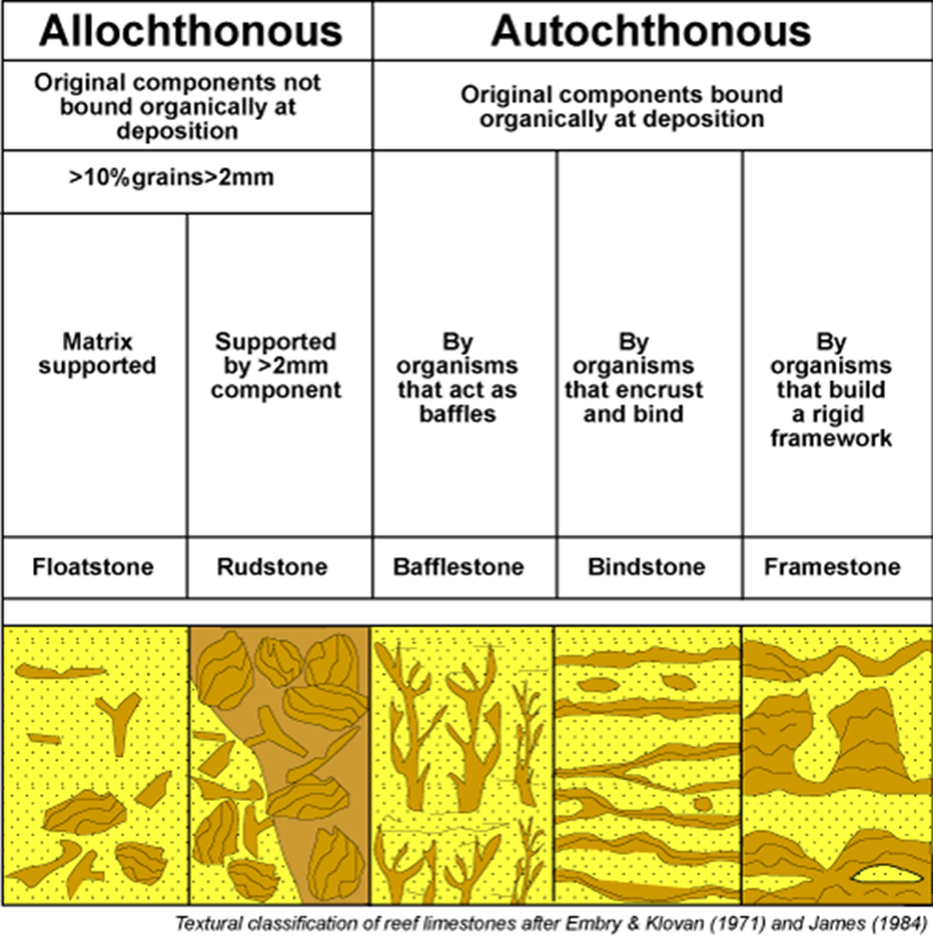
Carbonate classification
Embry-Klovan scheme
1)Autochthonous* or allochthonous#
●
2)* - Type of “activity” allochems were doing
# - Matrix or grain
supported
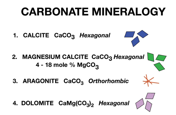
Carbonate
mineralogies
Carbonate equilibrium reactions
CO2(aq) + H2O <--> H2CO3
H2CO3 <--> HCO3- + H+
HCO3- <-->CO32- + H+
Carbonate compensation depth (CCD)

Ooid formation
- <2.0 mm diameter
(>2.0 = pisoids)
- Form wave-agitated waters, <6 m depth
- Nucleus can be any particle
- Grow from repeated precipitation of aragonite needles (chemical)
- Bio-mediated(?) with organic compounds
Carbonate grains: coated grains
Ooids – sand-sized coated grains, wave agitation, some nucleus (qtz, shell, ooid, etc.)
Peloids: Structureless ellipsoidal sand-sized grains, often poop or micritized grains
Pisoids: Concentrically coated, large (>2mm) spherical(ish) grain, forms in soils
Oncoids: Large (≥cm) irregularly coated carbonate grains – cyanobacterial origins
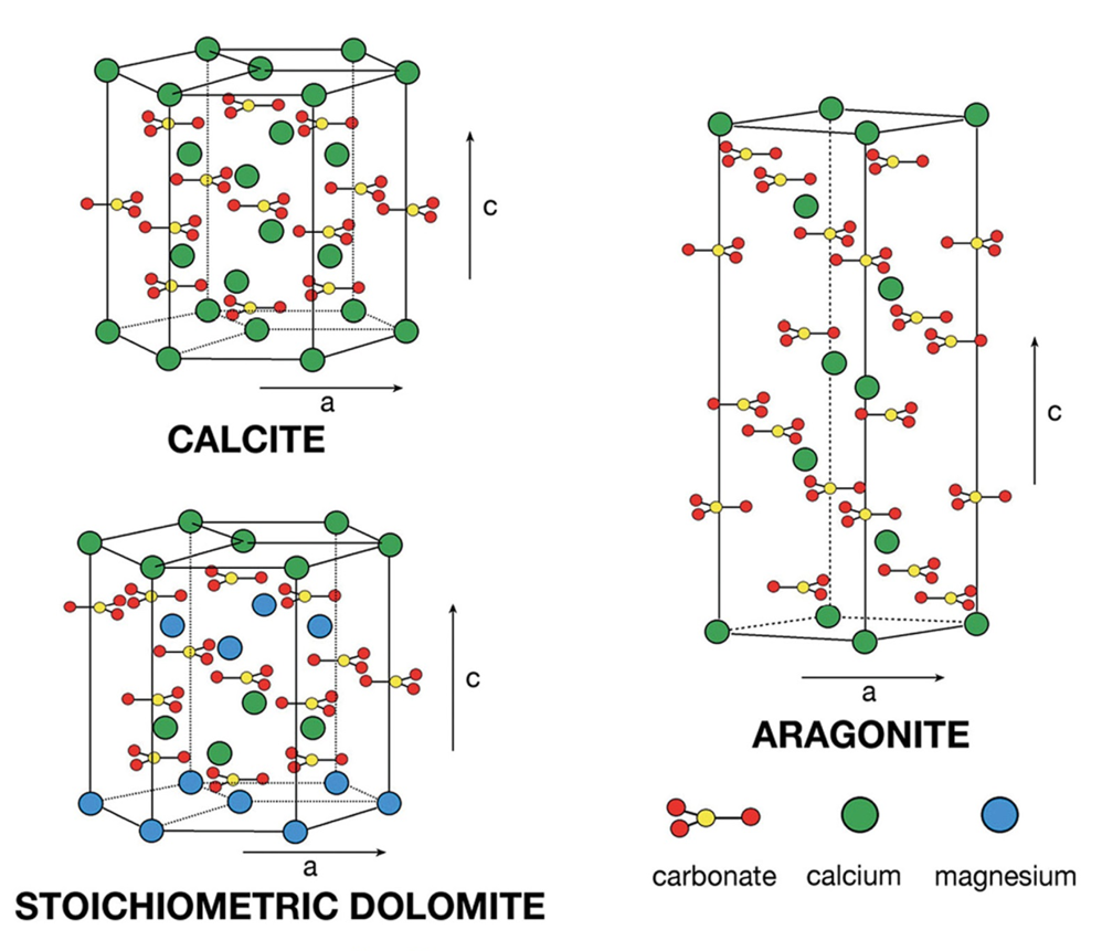
Carbonate polymorphs
Distribution of carbonates today
Carbonate platform buildup
If carbonate production outpaces tectonic subsidence, carbonate sediments will quickly reach sea level and stop aggradation
Progradation
lateral transport of sediment off shelf
Peritidal Carbonates
Periodic desiccation (low energy, tidal flat)
Salinity/temp variations
Laterally extensive bedded limestone and dolostone
Algal mats abundant, but no reefs…
Supratidal Zone
Submerged only during spring tide or storms
- Desiccation features
- Algal mats
- Evaporites
- Birds eye (fenestrae) and ‘chicken wire’ textures
- Tepee structures
- Grades into eolian (carbonate) dunes
Intertidal Zone
- Daily tides and waves
-
- Rippled carbonate mudflats
- Algal mats/stromatolites
(Shark Bay, Australia)
- Tidal channels
- ‘Breccia’ of shells and rip-ups
Subtidal Zone
- Always subaqueous, down to ~200 m (SWB)
- Normal marine
- Carbonate production keeps up, within photic zone
- Below wavebase, so mud can accumulate (but also huge clasts from storms)
Reef environments “real estate is everything”
- Positive relief structure , resistant carbonate buildup
- Built by organisms living in them
- Framework builders
Modern – coral
Ancient: clams, microbes,
stromatoporoids, archaeocyathans

Anatomy of a reef - Forereef
- Made up of reef debris and talus
-
- Large coral fragments (knocked off during storms)
- Bedding often inclined as it drapes the sides of the reef

Anatomy of a reef – Reef crest
- High-energy environment
- Coral lifestyles and form dictated by energy regime
- Reef crest grows up to essentially mean low tide level
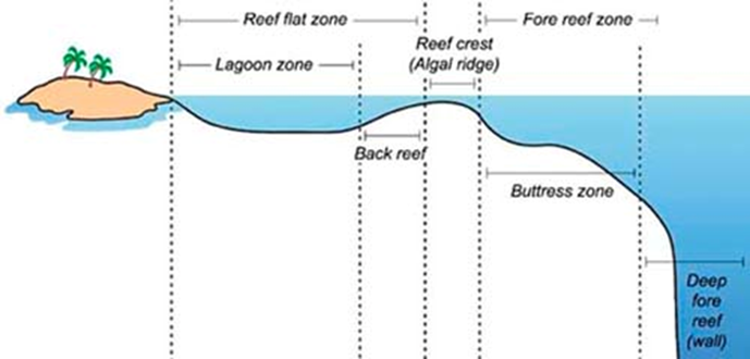
Anatomy of a reef – Back Reef
- Protected, only most severe storms pummel this habitat
- More branching- and platy-lifestyles for corals
- High diversity, optimal living conditions (?)

Anatomy of a reef – Lagoon
- Low-energy, often mud-rich sediments
-
- Patch reefs, rapid vertical growth (branching or mounding typical, not platy)
- Colonized by sea grasses and other delicate benthos
Dolomite and Dolomitization
1.Based on solubility and thermodynamics dolomite should form in seawater and should be the most abundant carbonate mineral.
2.About 50% of all carbonate rocks are dolomite.
3.Dolostone hosts many of the world’s base metal deposits.
4.Many petroleum carbonate reservoirs are dolostones.
5.Dolomite composition ranges from 42-55 mole % MgCO3
6.Dolomite that forms in modern sedimentary environments is calcium rich and poorly ordered. Ordering refers to the relative purity of calcium versus magnesium in the cation layers between those of carbonate.
7.Stoichiometric well-ordered dolomite is thermodynamically more stable relative to calcium-rich poorly ordered dolomite.
Reaction pathways: Primary Precipitate
Ca+2 + Mg+2 + 2CO3-2 = Ca,Mg(CO3)2
Cementation process – destroys porosity
Reaction Pathways Replacement Reaction
2CaCO3 + Mg+2 = CaMg(CO3)2 + Ca+2
Replacement texture, but creates porosity
Reaction Pathways: Replacement with volume conservation
(2 – X)CaCO3 + Mg+2 + XCO3-2 = Ca,Mg(CO3)2 + (1-X)Ca+2
Dolomitization Pathways:Cementation
Ca2+ + Mg2+ + 4HCO-3 à Ca,Mg(CO3)2 + 2CO2 + 2H2O
Dolomitization Pathways: Replacement
2CaCO3 + Mg2+ à CaMg(CO3)2 + Ca2+
Dolomitization Pathways: Mimetic Replacement
(2-X)CaCO3 + Mg2+ + XCO32- à Ca,Mg(CO3)2 + (1-X)Ca2+
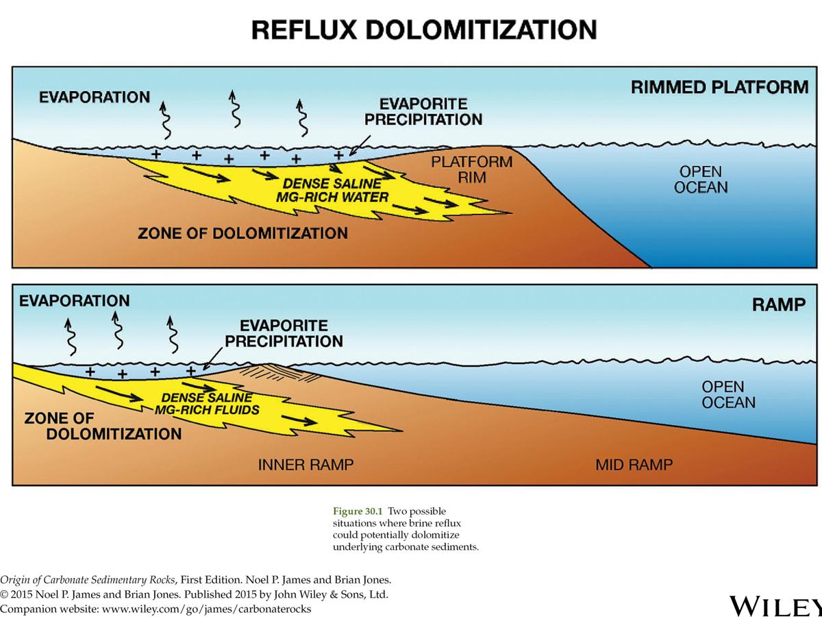
Reflux Dolomitization
Chemical Sediments
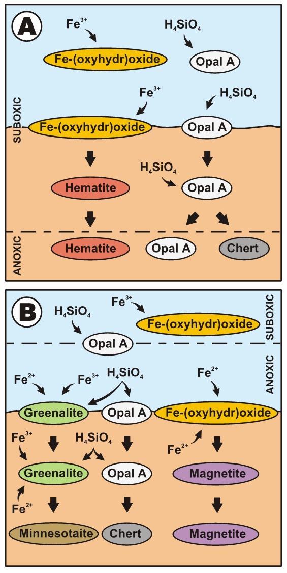
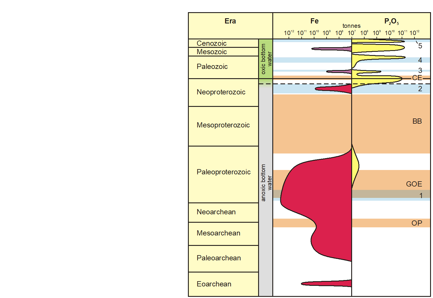
Iron Formation Model
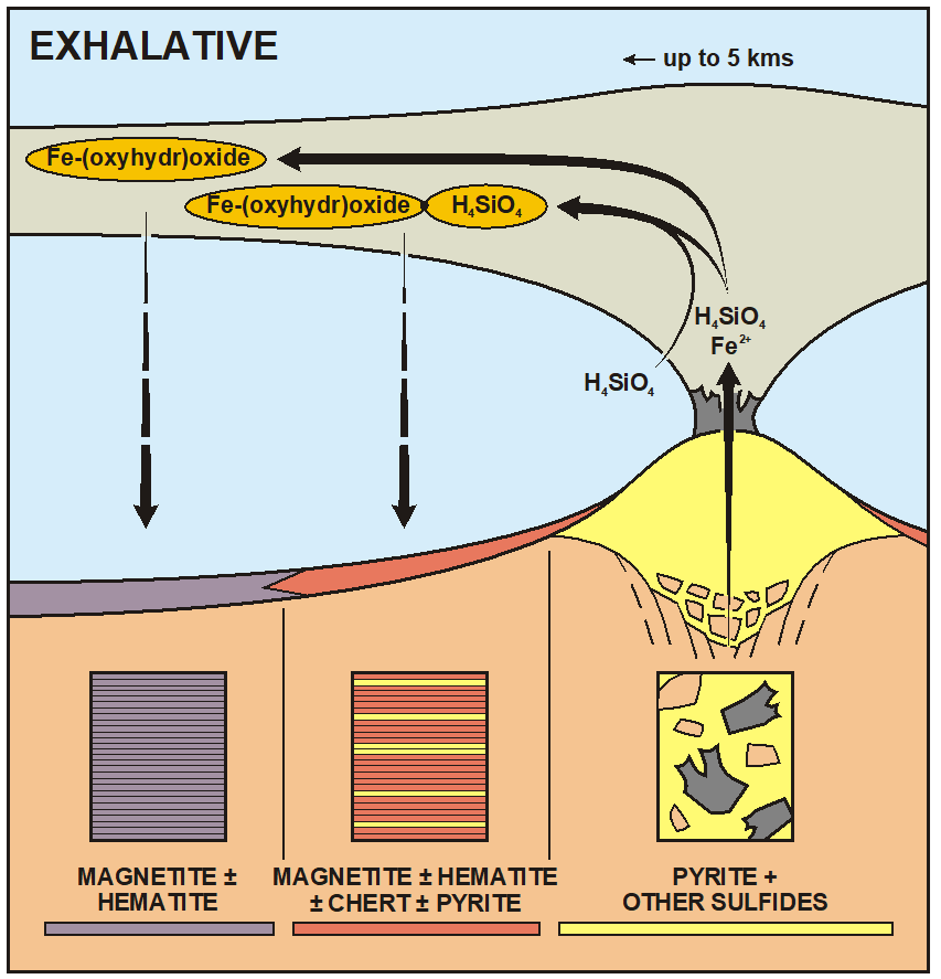
Iron formation formation
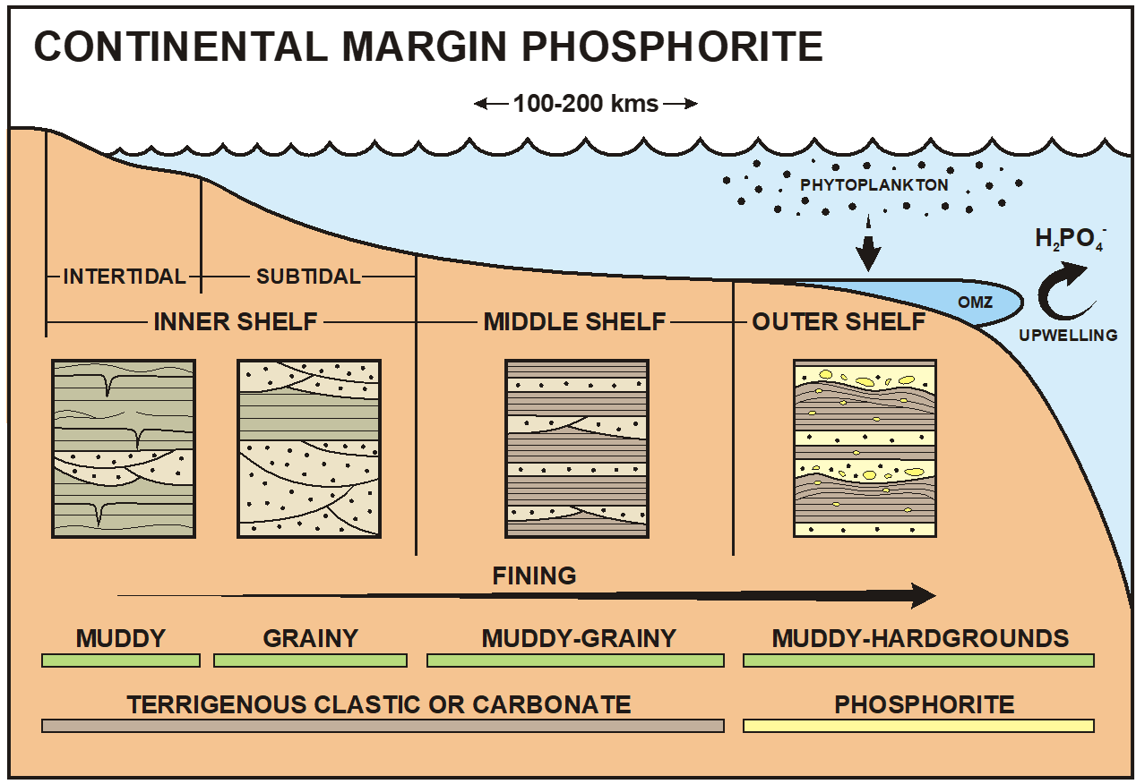
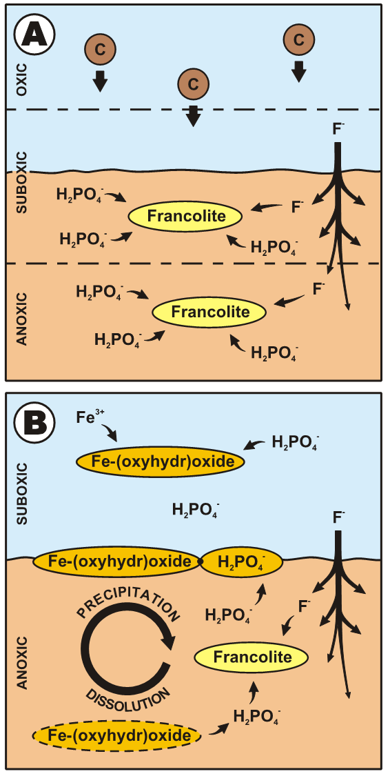
Phosphorites
Francolite:
(Ca,Mg,Sr,Na)10(PO4,SO4,CO3)6F2−3
Phanerozoic phosphorite model
Precambrian phosphorite formation
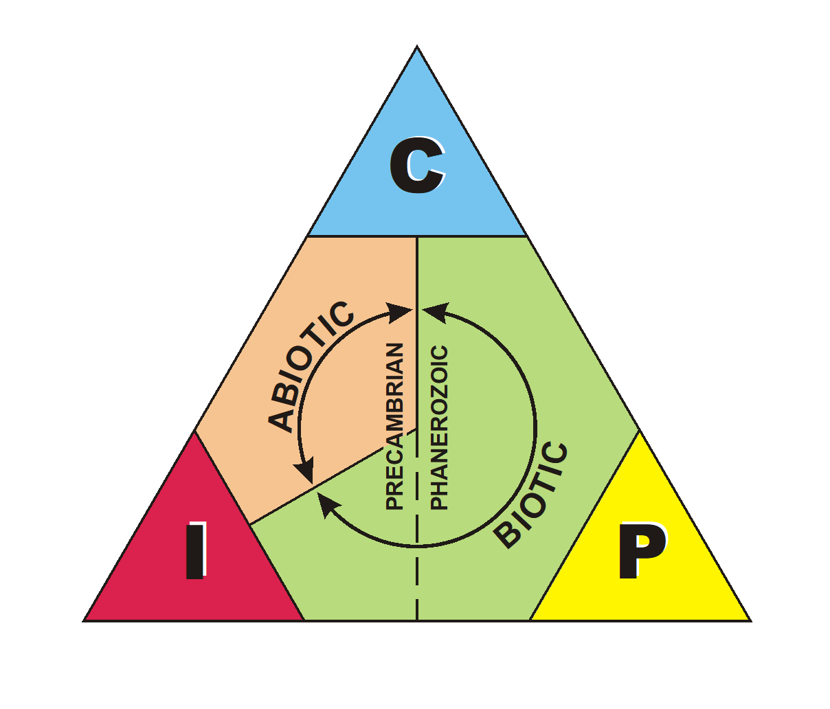
Biogenic sediments through time
Chert formation – biogenic(?)

Castille Formation
Shallow evaporitic basin with laminated gypsum and calcite ppts
Eolian environments
Climate (arid)
Topography (rain shadows)
Latitude
Continentality
Milankovitch cycles
Eolian environments on Earth
30 degrees latitude where most deserts are
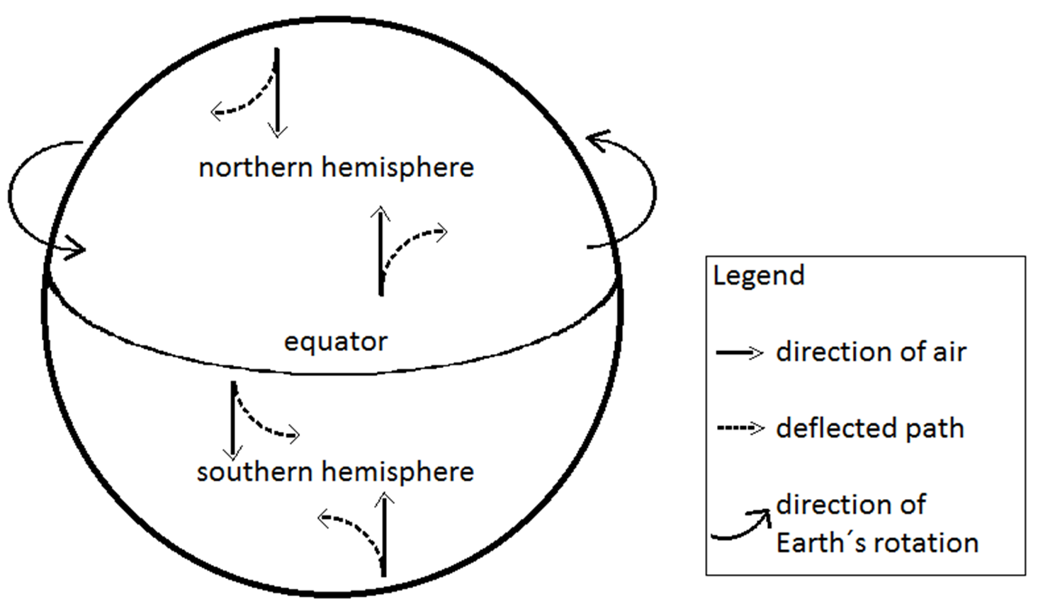
Coriolis Effect on wind patterns
NH clockwise(right)
SH counter clockwise(left)
Eolian systems
- Sand dunes (deserts and coastal systems)
- Can be paleolatitude indicators (10º–30º)
- Arid region indicator, shows wind direction
Dune environments
- Fine sand to silt
- Bedforms (x bdd)
- Intradune deposits (ponds and mudcracks, ± fossils, evaporites)
- Desert pavement ± ventifacts
Types of dunes
Barchan, Parabolic, Transverse, Longitudinal
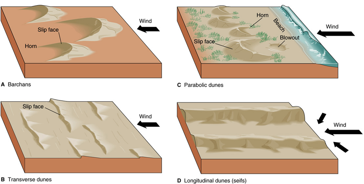
What dictates dune type…
Transport in wind
- Dust devils pick up finer fraction
- Sand-sized particles move by saltation and grain collision.
- Results in well-sorted,
well-rounded, and pitted
grains (frosted)
Dunes are mainly quartz, but there are exceptions (gypsum)
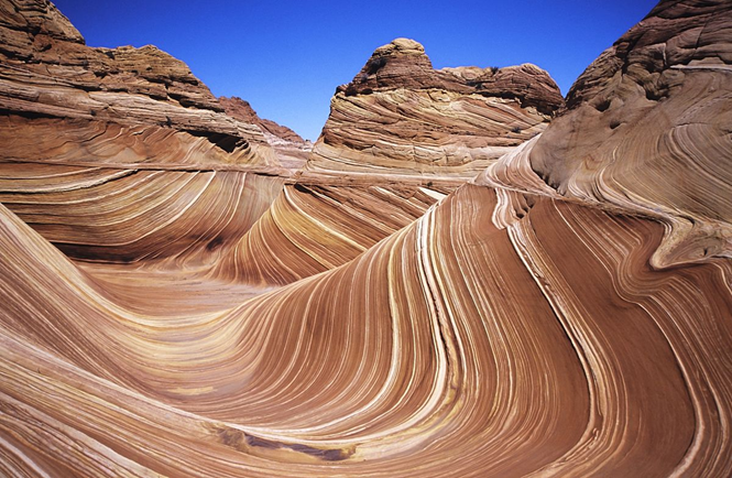
Eolian cross-bedding
Can be up to 35 m high
Foresets dip at 20º – 30º
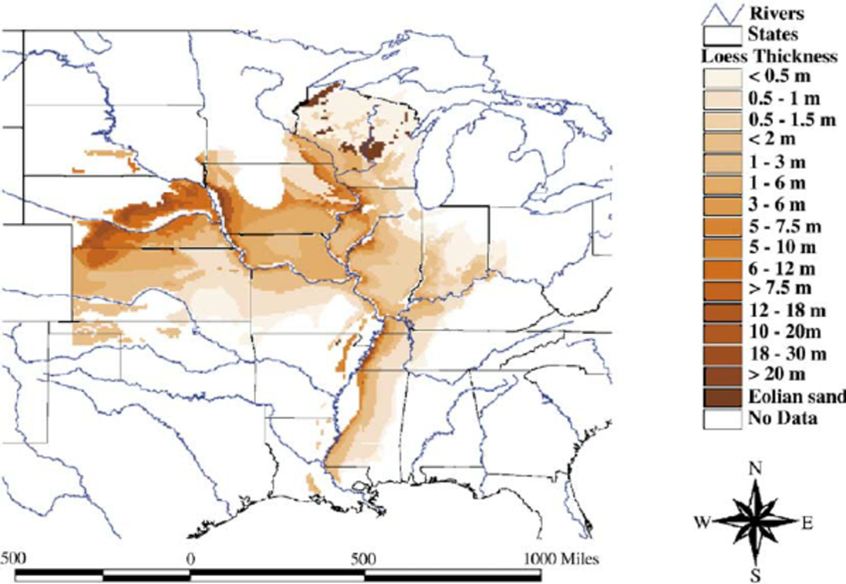
Loess
wind-blown silt deposits
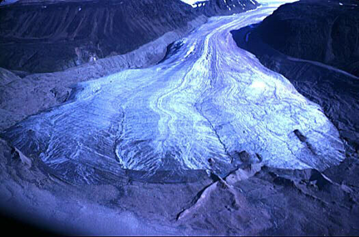
Glacial processes
- Slow moving ice flow; picks up all grain sizes
- Pick up sediments, “scours” the terrain as the glacier moves over
- Alpine (mountain) vs. continental glaciers
Zone of accumulation
more snow falls than is lost
Zone of ablation
more snow lost.
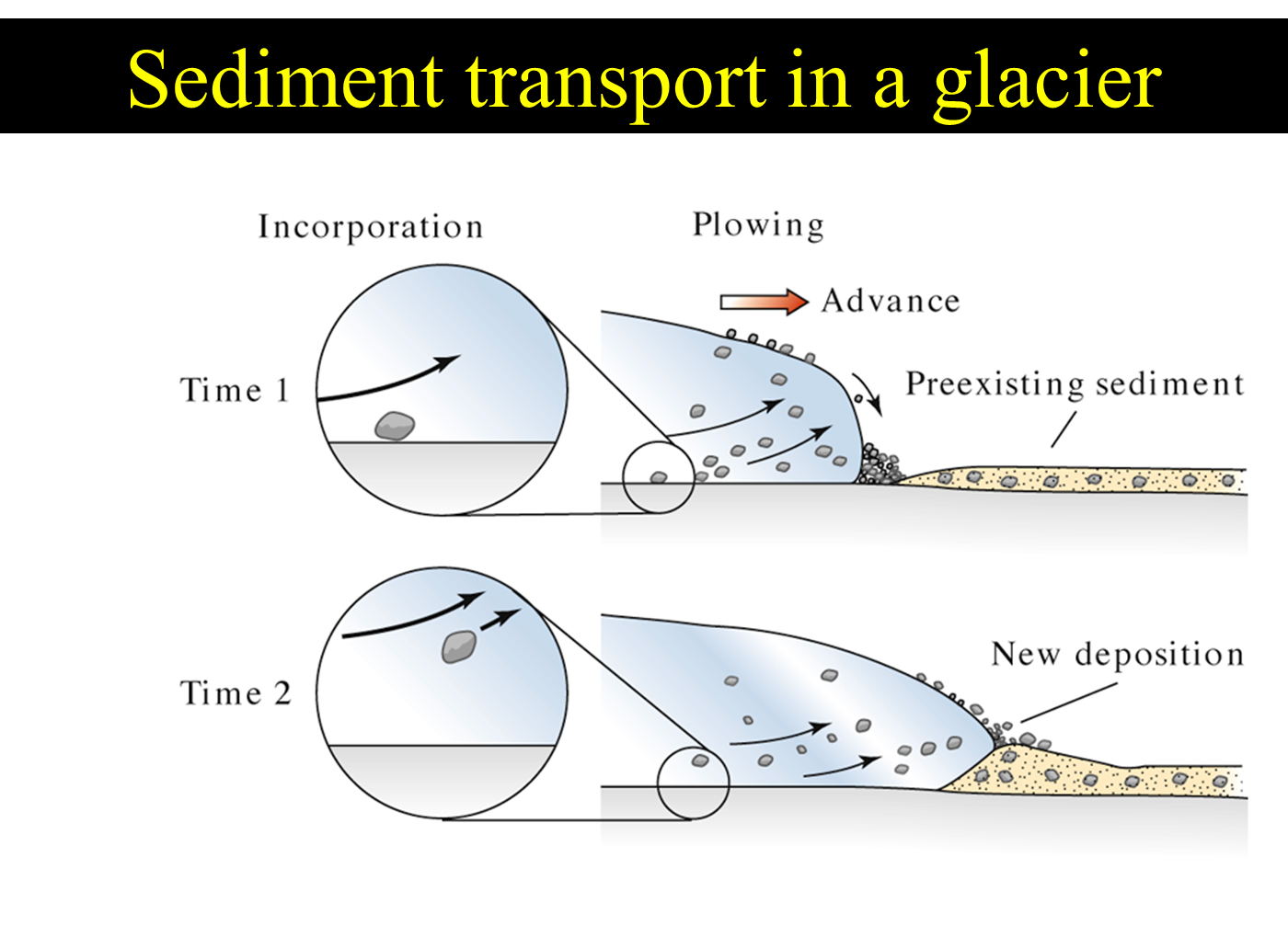
Sediment transport in a glacier
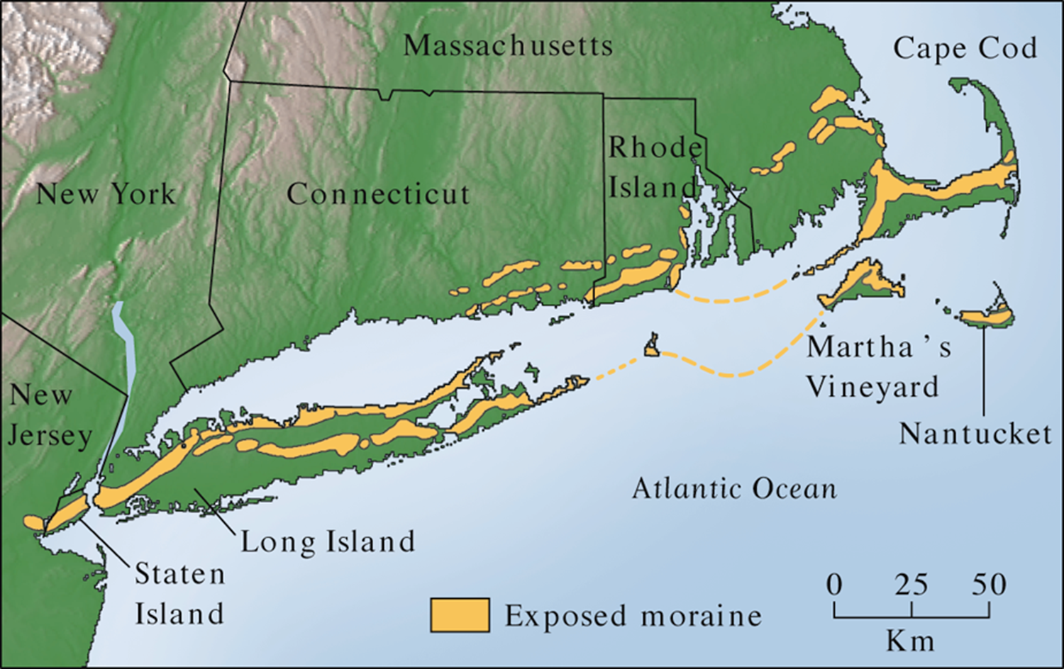
The terminal moraine from the LGM
Glacial erosion
polishing, chattermarks, striations
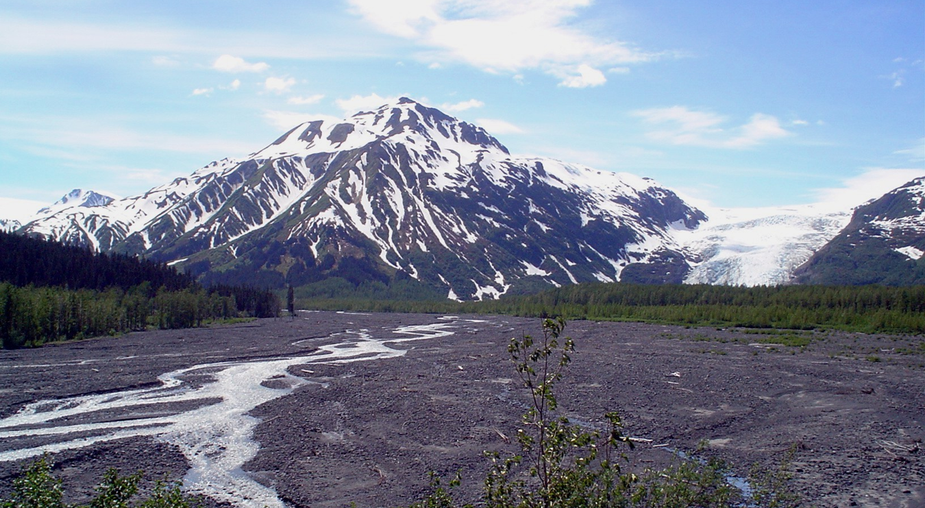
Outwash Plain
Braided river deposits from meltwater (downstream)
Till and tillites
•Poorly sorted
•No internal stratification
•Called “diamictite” if of unknown source, or “tillite” if from a glacier
•Striations on clasts can help identify if the deposit is glacial or not (if striations present = glacial)
Glacial sediments in proglacial lakes
glacial flour varves
Glacial Deposits
Outwash plains have braided streams that carry sand and glacial flour, and have gravel bars of cobbles and boulders
Glacial Essentials
•Found where temps are cold, and summers don’t melt ice/snow
•Sequence: till at base, gravel bars or cross-bedded sands, then varves (possibly)
•Tills are poorly sorted, non-stratified; varves are layered; fossils possible including diatoms, leaves, some verts
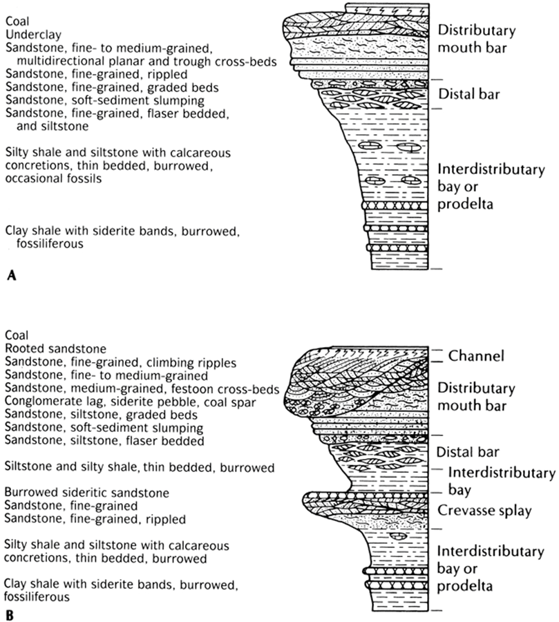
Deltas
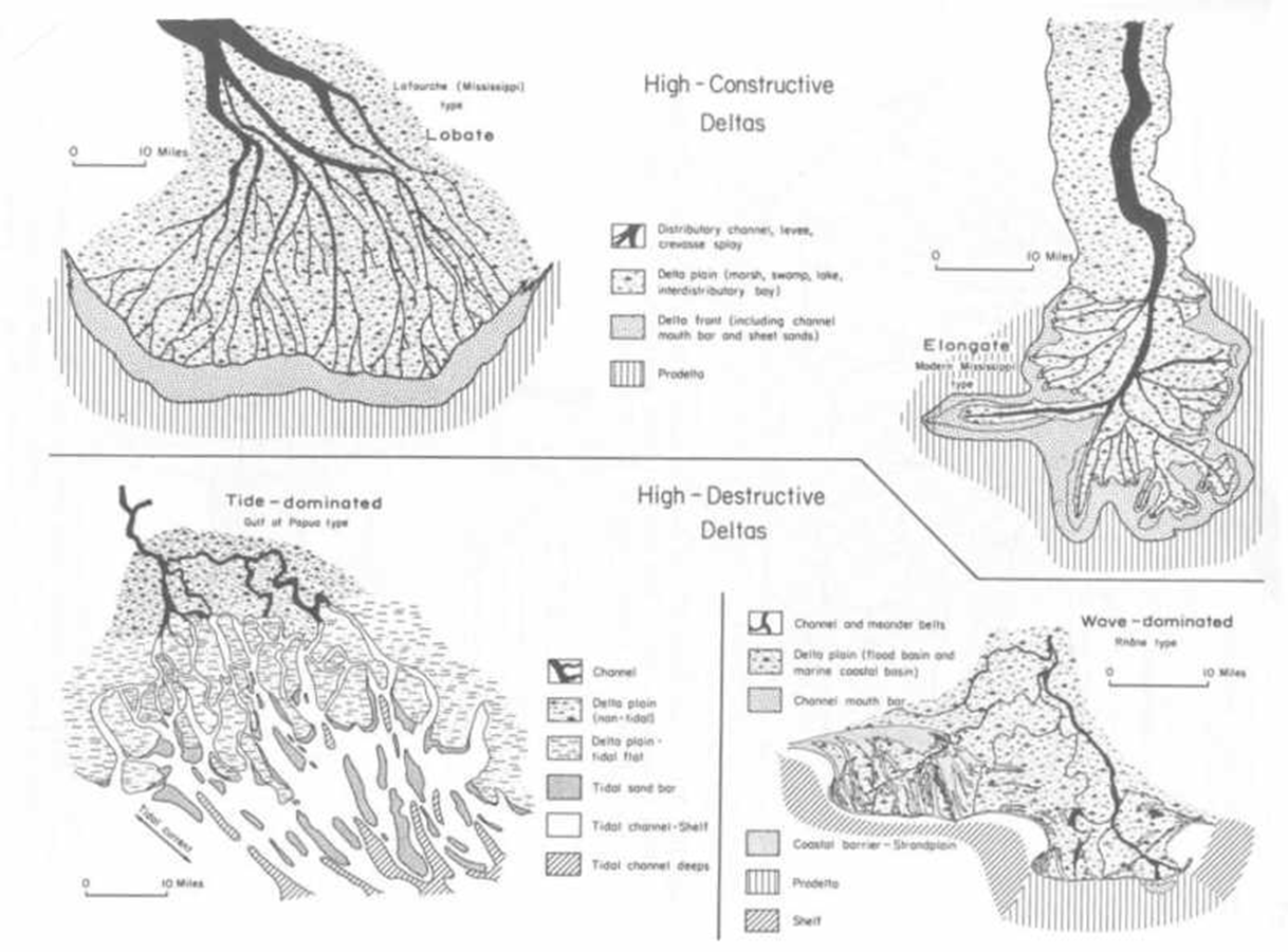
Delta facies models
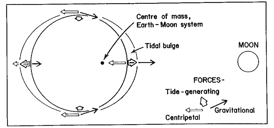
Why do we have tides?
Delta Environments
Delta (D) – running water from streams enters standing water (ocean)
(Deposits more sediment than longshore drift can carry away)
Delta Facts
Found on passive margins.
1. Needs a stable shelf on which seds can accumulate.
2. No coastal mountain ranges; means large river basins that provide deltaic sediments can form
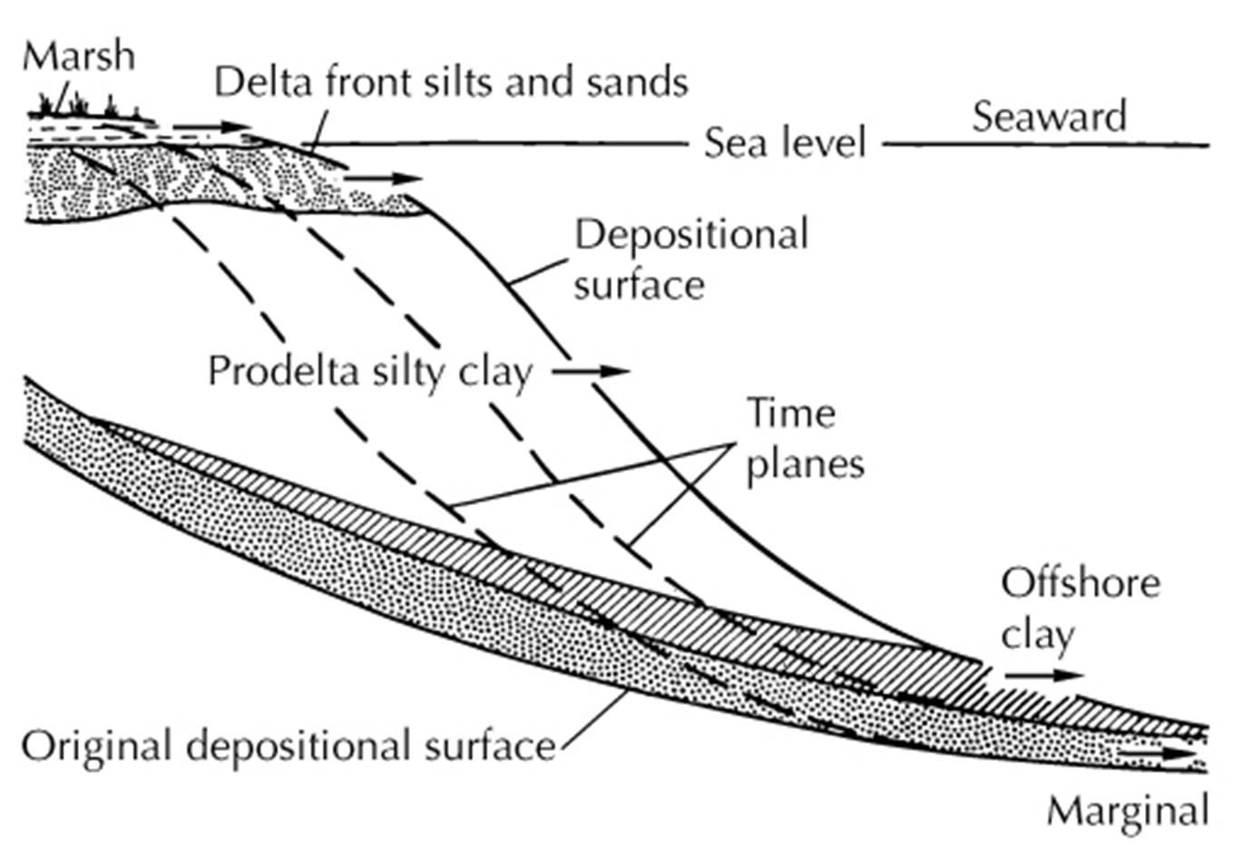
Deltas build outward (Progradation)
Delta plain = meandering floodplain, swamp, beach
Delta front = steeper, may show sands and channels
Prodelta = sloping down to open shelf
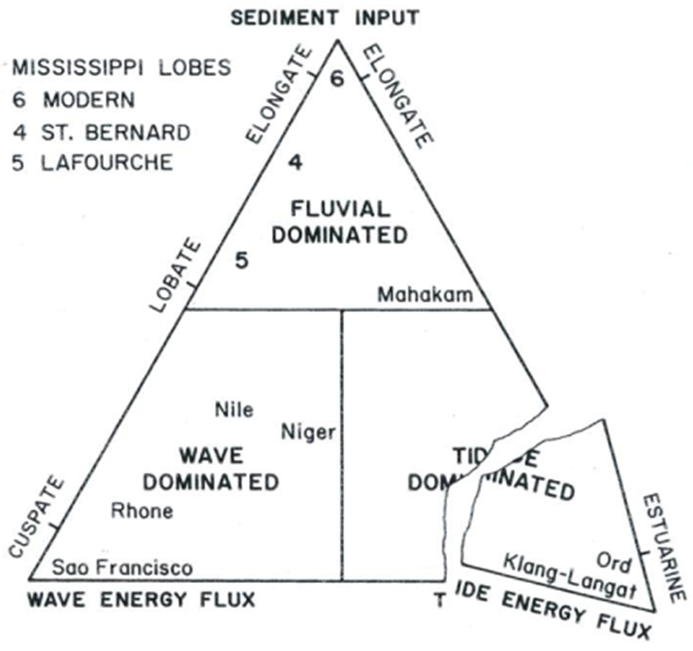
Delta shape depends on sed input, wave energy, tides…
Typical sequence shows coarsening upwards as delta progrades (builds seaward)…
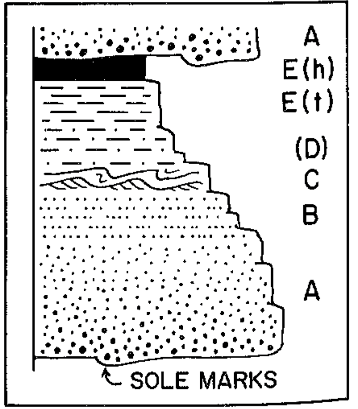
Submarine fans
Bouma sequences (turbidites)
E – Suspended seds (mud and hemipelagic “organic snow”)
D – Laminated seds (LPB)
C – Ripples (x-bdd)
B – Laminated seds (UPB)
A – Massive to graded beds
Scour
Laterally and vertically adjacent (Walther’s Law)
What causes turbidites?
High sedimentation from the shelf
Seismic events (seismites)
Storm events (tempestites)
Sea level fall
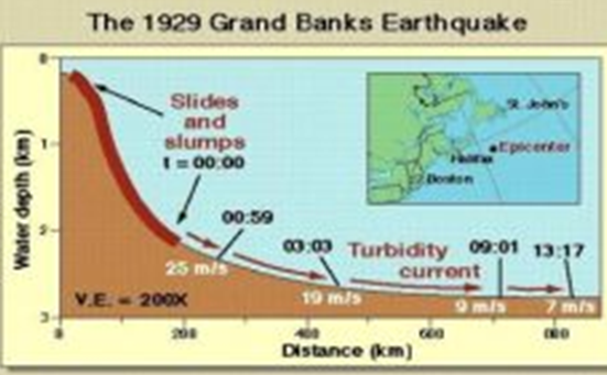
Turbidity currents in the “modern”
200 km3 of sediment more than 1100 km
40-60 mph
Lithostratigraphy
rock properties
Magnetostratigraphy
magnetic remanence
Biostratigraphy
– fossil assemblages (biozones)
Chemostratigraphy
chemical properties (isotopes)
Well logging
borehole properties
Seismic stratigraphy
subsurface acoustic properties