Orbitals, Resolution, & Sensor Physics
1/49
There's no tags or description
Looks like no tags are added yet.
Name | Mastery | Learn | Test | Matching | Spaced | Call with Kai |
|---|
No study sessions yet.
50 Terms
According to Kepler's Third Law-- what is the fundamental relationship between a satellite's orbital altitude and its orbital period?
For any particular altitude-- there is only one possible orbital period-- and vice-versa.
What is the mathematical proportionality described by Kepler's Third Law for orbital period (T) and orbital radius (r)?
The square of the orbital period is proportional to the cube of the orbital radius-- expressed as:
T2=(4π2/(G*M))*r3
T2∝r3
If a satellite in a stable circular orbit slows down-- what will happen to the altitude of its orbit?
It will necessarily increase the altitude of its orbit.
An orbit where the satellite passes over a location at the same local solar time during each visit is known as a ____ orbit.
Sun-synchronous orbit (SSO)
What is the primary advantage of a Sun-synchronous orbit for remote sensing?
It provides consistent lighting conditions-- ensuring changes in images are due to surface changes-- not different shadow angles.
A ____ orbit is a type of geosynchronous orbit that is specifically equatorial with zero inclination and eccentricity-- making the satellite appear stationary from the ground.
Geostationary (GEO)
Why might a scientist choose a Geostationary orbit over a Sun-synchronous orbit for monitoring a hurricane?
GEO provides continuous observation over one area-- which is essential for tracking the rapid development and movement of a storm.
What is the trade-off in spatial resolution when choosing a Geostationary orbit for hurricane monitoring?
GEO satellites are at a very high altitude (~35--786 km)-- resulting in lower spatial resolution compared to satellites in Low Earth Orbit.
Satellites in _____ have orbital periods shorter than one day.
Low Earth Orbit (LEO) and Medium Earth Orbit (MEO)
What is the typical altitude range for Low Earth Orbit (LEO)?
160 to 2000 km.
What is a key advantage of LEO satellites regarding image quality?
Their proximity to Earth allows for detailed imaging and high spatial resolution.
What is a significant disadvantage of LEO satellites related to observation time?
They have a short observation time per location due to their high speed.
The altitude range between 2000 km and 35786 km is classified as _.
Medium Earth Orbit (MEO)
GPS satellites are a prime example of spacecraft found in which orbital regime?
Medium Earth Orbit (MEO)-- at an altitude of approximately 20--200 km.
Why are there fewer satellites in MEO compared to LEO or GEO?
The presence of the Van Allen radiation belts-- which can damage satellite electronics-- makes this region challenging.
What defines a High Earth Orbit (HEO)?
A geocentric orbit with an altitude above the geosynchronous altitude of 35786 km.
What is the defining characteristic of a geosynchronous orbit (GSO) in terms of its period?
It has an orbital period that matches Earth's rotation-- one sidereal day (23 hours 56 minutes 4 seconds).
If a GSO satellite has an inclination greater than zero-- what pattern does it trace in the sky from a ground observer's perspective?
It traces a figure-8 pattern-- known as an analemma.
What type of orbit offers full global coverage because the Earth's rotation brings every latitude under the satellite's path?
A polar orbit.
What is the typical altitude range for satellites in a Sun-synchronous orbit?
Between 600 to 800 km.
What is a primary advantage of a Highly Elliptical Orbit (HEO)?
The satellite moves slowly near its apogee-- creating a long dwell time over specific regions-- which is good for polar coverage.
The ground distance represented by one pixel in a satellite image is known as ____.
Ground Sample Distance (GSD)
What is the formula for calculating Ground Sample Distance (GSD) using satellite height (h) and instantaneous field of view (θ)?
GSD = H * θ (in radians)
What does IFOV-- or Instantaneous Field of View-- represent?
The angular cone of visibility of the sensor-- which determines the area on the Earth's surface seen at one particular moment in time.
What is the term for the time it takes for a satellite to complete one full orbit cycle and revisit the same location?
Temporal resolution or revisit time.
The ability of a sensor to distinguish between different wavelengths of the electromagnetic spectrum is called ____ resolution.
Spectral resolution.
In the context of satellite imagery, _____ resolution refers to the ground surface area that forms a single pixel in the image.
Spatial resolution
What is radiometric resolution?
It describes a sensor's ability to discriminate differences in energy or radiance-- essentially the number of brightness levels it can record.
What type of radiation is dominant in sunlight reaching the top of the atmosphere?
Shortwave radiation-- with a peak in the visible light spectrum.
What type of radiation is dominant in thermal emissions from the Earth's surface?
Longwave radiation-- with a peak in the thermal infrared part of the spectrum.
Which law states that the peak emission wavelength of a blackbody is inversely proportional to its temperature?
Wien's Displacement Law.
Which law describes the total power radiated per unit area of a black body as being proportional to the fourth power of its temperature?
The Stefan-Boltzmann Law.
What is the primary mission of the GOES satellite series?
To support weather forecasting-- severe storm tracking-- and meteorology research with continuous imagery and measurements.
Which two U.S. government agencies jointly operate the GOES satellites?
NASA and NOAA.
What is the primary imaging instrument on the GOES-R series satellites-- responsible for 65% of all data?
The Advanced Baseline Imager (ABI).
What is the function of the Geostationary Lightning Mapper (GLM) instrument on GOES satellites?
It is a near-IR detector that continuously monitors total lightning (in-cloud and cloud-to-ground) to alert forecasters to severe weather.
The GOES ABI instrument can be used for nighttime fog and low cloud detection using which spectral band type?
Shortwave IR (specifically Band 7 at ~3.9 µm).
The GOES ABI water vapor bands (Bands 8-10) are essential for forecasting what phenomena?
Jet stream and hurricane tracks.
Why is the GOES-16 satellite's high temporal resolution crucial for its mission?
It provides rapid-- continuous updates essential for tracking the fast development and movement of severe weather like hurricanes and tornadic thunderstorms.
Which instrument on GOES satellites produces full-disk images of the sun in UV to locate phenomena like coronal holes and solar flares?
The Solar UV Imager (SUVI).
How are satellites with radar altimeters used to map the ocean floor from space?
They detect small changes in sea surface elevation caused by the gravitational attraction of large seafloor features like seamounts and canyons.
What type of orbit has an eccentricity value of e = 0?
A circular orbit.
What is the range of eccentricity e for an elliptic orbit?
0 < e < 1
An orbit that travels in the same direction as the rotation of the primary body (e.g.-- eastward for Earth) is called a _____ orbit.
Prograde orbit
An orbit that travels counter to the direction of the primary body's rotation is called a ____ orbit.
Retrograde orbit
A _____ orbit has an orbital period equal to half of the primary body's rotational period-- like the GPS constellation.
Semi-synchronous orbit
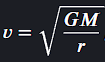
What is the formula for the orbital velocity (V) of a satellite in a circular orbit?
where G is the gravitational constant-- M is the mass of the central body-- and r is the orbital radius.
What is the primary instrument aboard GOES-16 used for monitoring solar flares and anticipating radio blackouts?
Extreme UV and X-ray Irradiance Sensors (EXIS).
The technology of acquiring information about the Earth's surface without being in physical contact with it is known as _.
Remote sensing.
A sensor that detects natural energy (radiation) that is emitted or reflected by the object or scene being observed is a ____ sensor.
Passive sensor.