FAA PPL Test Prep: Ch. 9 (2 of 2): Enroute Flight Questions

0.0(0)
learnLearn
examPractice Test
spaced repetitionSpaced Repetition
heart puzzleMatch
flashcardsFlashcards
Card Sorting

1/21

encourage image

There's no tags or description

Looks like no tags are added yet.

Study Analytics
Name
Mastery
Learn
Test
Matching
Spaced

No study sessions yet.

22 Terms

1
New cards

A) 36°24'N - 76°01'W.

(Refer to Figure 20, area 3.) Determine the approximate latitude and longitude of Currituck County Airport.

A) 36 24N - 76 01 W
B) 36 48N - 75 58W
C) 47 24N - 75 58W
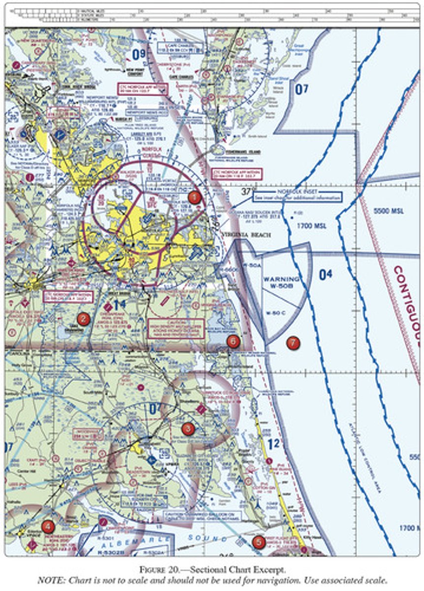
<p>(Refer to Figure 20, area 3.) Determine the approximate latitude and longitude of Currituck County Airport.</p><p>A) 36 24N - 76 01 W<br>B) 36 48N - 75 58W<br>C) 47 24N - 75 58W</p>
2
New cards

B) Makeeff.

(Refer to Figure 21, area 2.) Which airport is located at approximately 47°34'30"N latitude and 100°44'00"W longitude?

A) Turtle Creek
B) Makeeff
C) Johnson
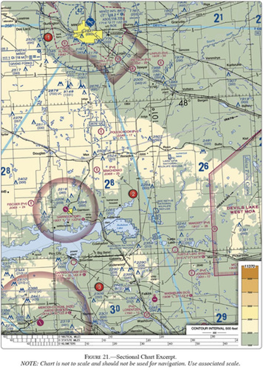
<p>(Refer to Figure 21, area 2.) Which airport is located at approximately 47°34'30"N latitude and 100°44'00"W longitude?</p><p>A) Turtle Creek<br>B) Makeeff<br>C) Johnson</p>
3
New cards

C) Washburn.

(Refer to Figure 21, area 3.) Which airport is located at approximately 47°21'N latitude and 101°01'W longitude?

A) Lorentzen
B) Johnson
C) Washburn
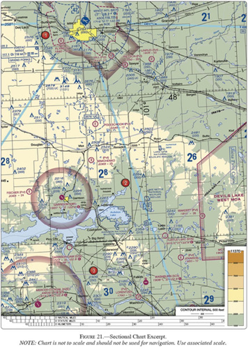
<p>(Refer to Figure 21, area 3.) Which airport is located at approximately 47°21'N latitude and 101°01'W longitude?</p><p>A) Lorentzen<br>B) Johnson<br>C) Washburn</p>
4
New cards

B) 47°33'N - 116°11'W.

(Refer to Figure 22, area 3.) Determine the approximate latitude and longitude of Shoshone County Airport.

A) 47 02' - 116 11'W
B) 47 33'N - 116 11'W
C) 47 32'N - 116 41'W
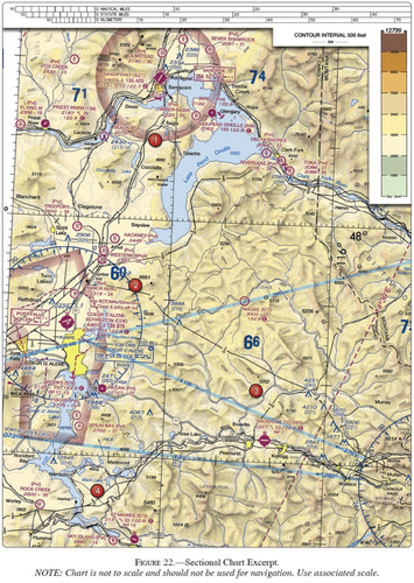
<p>(Refer to Figure 22, area 3.) Determine the approximate latitude and longitude of Shoshone County Airport.</p><p><span>A) 47 02' - 116 11'W</span><br><span>B) 47 33'N - 116 11'W</span><br><span>C) 47 32'N - 116 41'W</span></p>
5
New cards

A) 47°25'N - 98°06'W.

(Refer to Figure 26, area 2.) What is the approximate latitude and longitude of Cooperstown Airport?

A) 47 25'N - 98 06'W
B) 47 25'N - 99 54'W
C) 47 55'N - 98 06'W
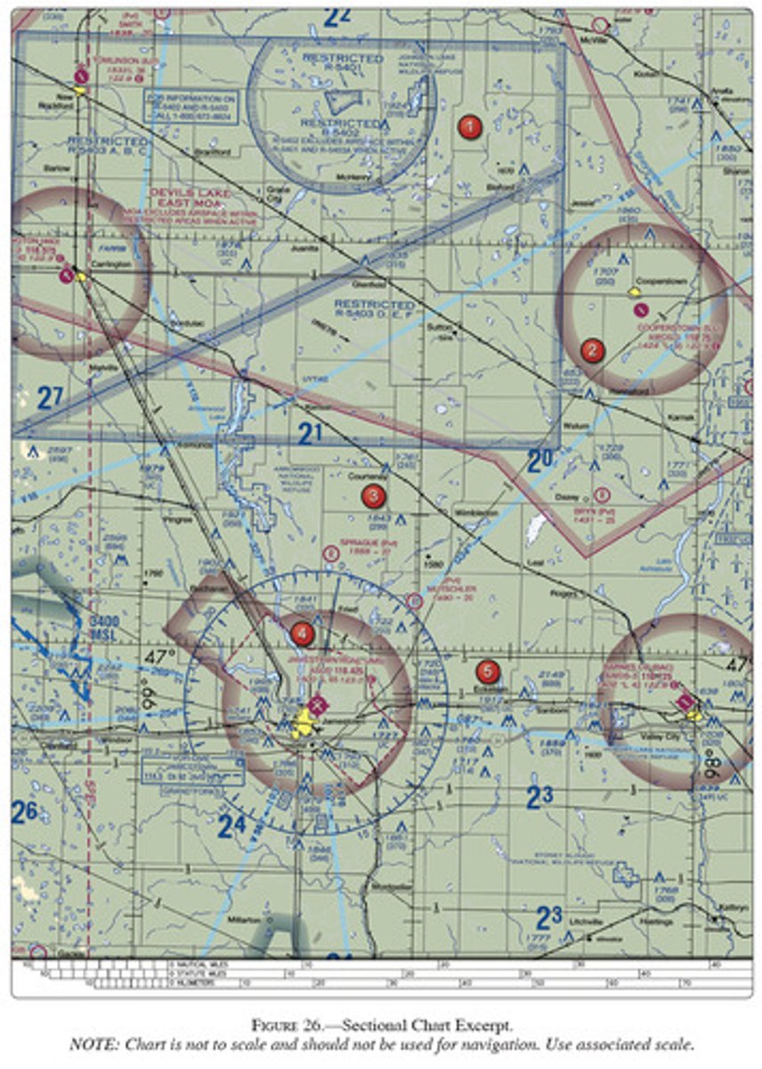
<p>(Refer to Figure 26, area 2.) What is the approximate latitude and longitude of Cooperstown Airport?</p><p><span>A) 47 25'N - 98 06'W</span><br><span>B) 47 25'N - 99 54'W</span><br><span>C) 47 55'N - 98 06'W</span></p>
6
New cards

C) 1545Z.

(Refer to Figure 27.) An aircraft departs an airport in the eastern daylight time zone at 0945 EDT for a 2-hour flight to an airport located in the central daylight time zone. The landing should be at what coordinated universal time?

A) 1345Z
B) 1445Z
C) 1545Z
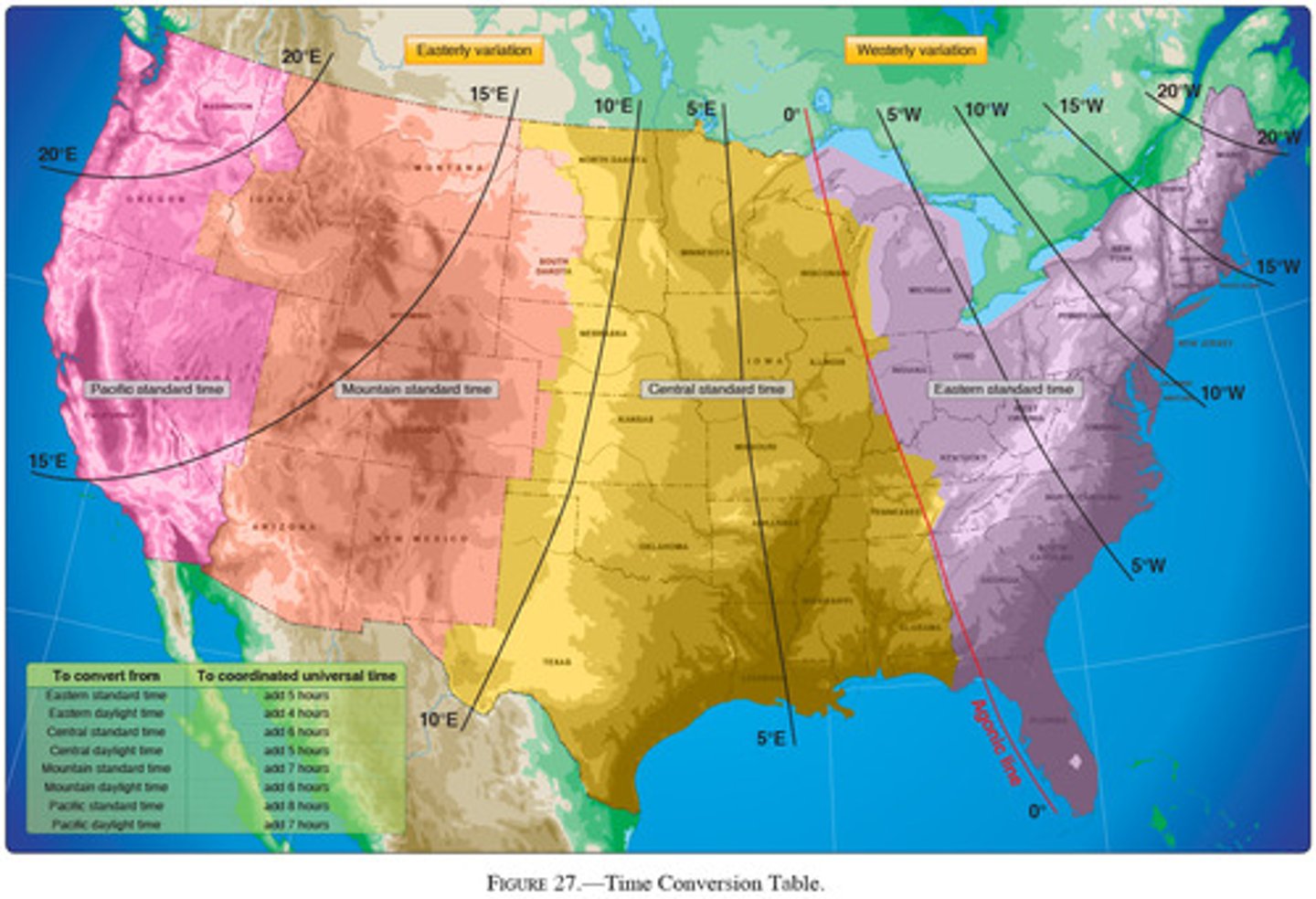
<p>(Refer to Figure 27.) An aircraft departs an airport in the eastern daylight time zone at 0945 EDT for a 2-hour flight to an airport located in the central daylight time zone. The landing should be at what coordinated universal time?</p><p><span>A) 1345Z</span><br><span>B) 1445Z</span><br><span>C) 1545Z</span></p>
7
New cards

B) 1030 MST

(Refer to Figure 27.) An aircraft departs an airport in the central standard time zone at 0930 CST for a 2-hour flight to an airport located in the mountain standard time zone. The landing should be at what time?

A) 0930 MST
B) 1030 MST
C) 1130 MST
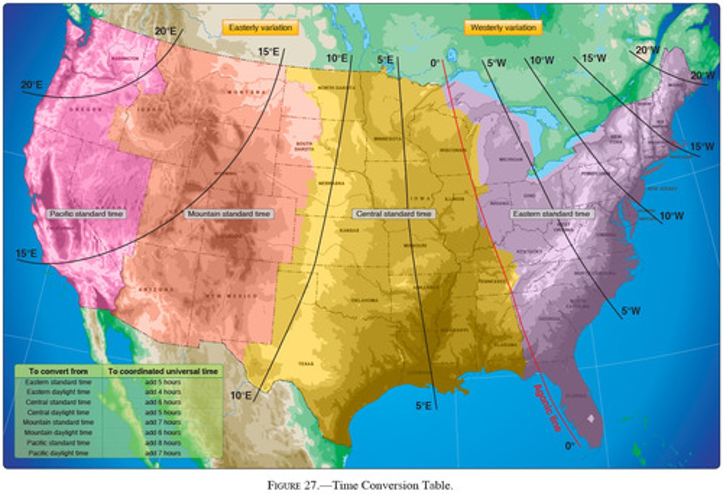
<p>(Refer to Figure 27.) An aircraft departs an airport in the central standard time zone at 0930 CST for a 2-hour flight to an airport located in the mountain standard time zone. The landing should be at what time?</p><p><span>A) 0930 MST</span><br><span>B) 1030 MST</span><br><span>C) 1130 MST</span></p>
8
New cards

C) 1645Z.

(Refer to Figure 27.) An aircraft departs an airport in the central standard time zone at 0845 CST for a 2-hour flight to an airport located in the mountain standard time zone. The landing should be at what coordinated universal time?

A) 1345Z
B) 1445Z
C) 1645Z
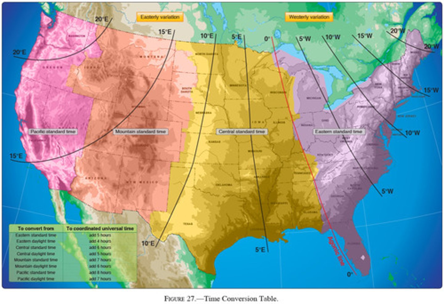
<p>(Refer to Figure 27.) An aircraft departs an airport in the central standard time zone at 0845 CST for a 2-hour flight to an airport located in the mountain standard time zone. The landing should be at what coordinated universal time?</p><p><span>A) 1345Z</span><br><span>B) 1445Z</span><br><span>C) 1645Z</span></p>
9
New cards

B) 1730 PST

(Refer to Figure 27.) An aircraft departs an airport in the mountain standard time zone at 1615 MST for a 2-hour 15-minute flight to an airport located in the Pacific standard time zone. The estimated time of arrival at the destination airport should be

A) 1630 PST
B) 1730 PST
C) 1830 PST
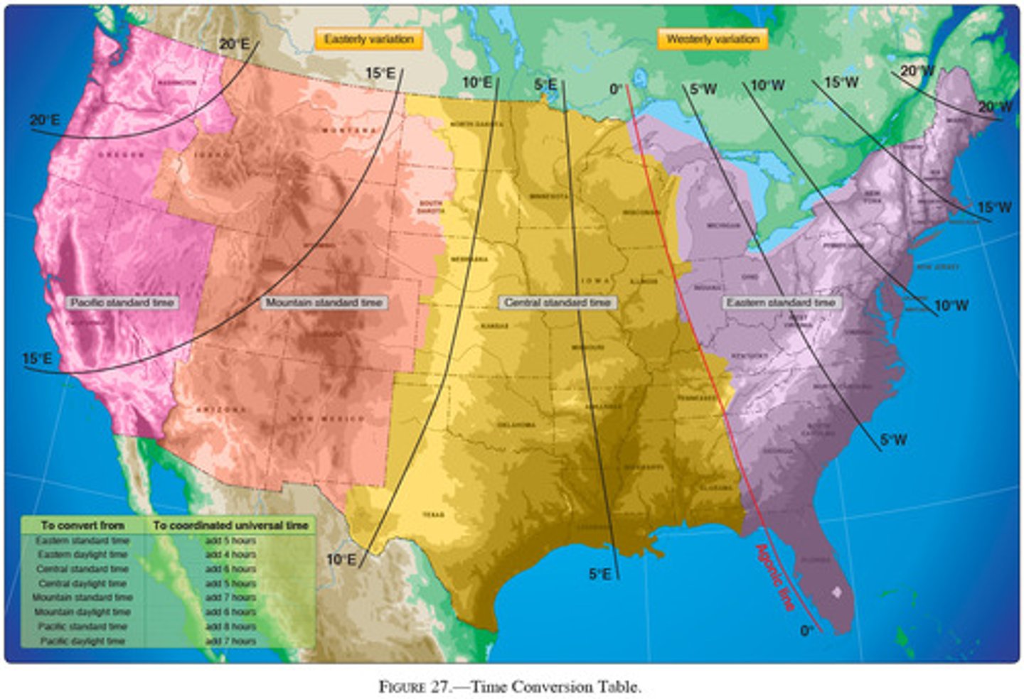
<p>(Refer to Figure 27.) An aircraft departs an airport in the mountain standard time zone at 1615 MST for a 2-hour 15-minute flight to an airport located in the Pacific standard time zone. The estimated time of arrival at the destination airport should be</p><p><span>A) 1630 PST</span><br><span>B) 1730 PST</span><br><span>C) 1830 PST</span></p>
10
New cards

C) 2230Z.

(Refer to Figure 27.) An aircraft departs an airport in the Pacific standard time zone at 1030 PST for a 4-hour flight to an airport located in the central standard time zone. The landing should be at what coordinated universal time?

A) 2030Z
B) 2130Z
C) 2230Z
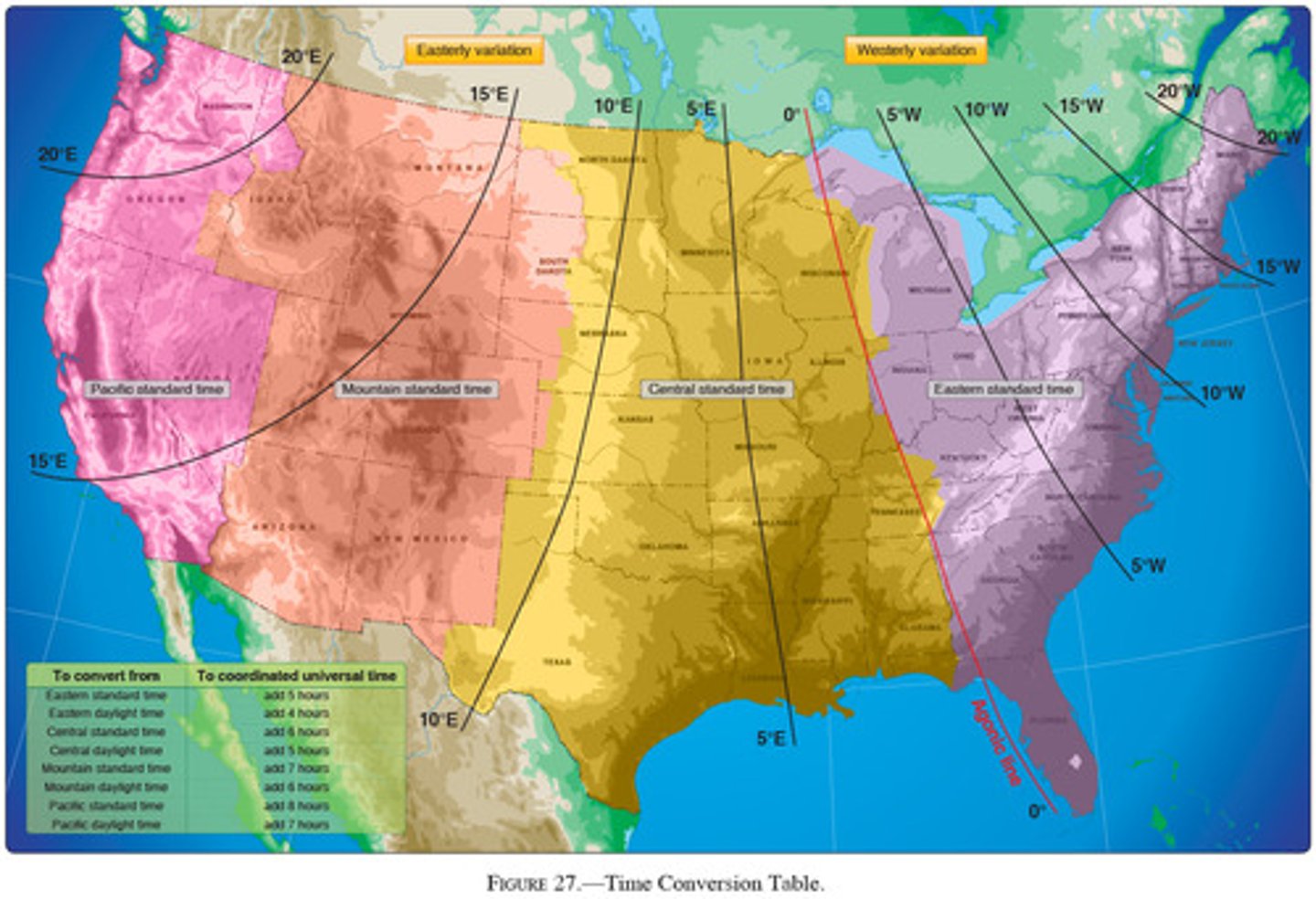
<p>(Refer to Figure 27.) An aircraft departs an airport in the Pacific standard time zone at 1030 PST for a 4-hour flight to an airport located in the central standard time zone. The landing should be at what coordinated universal time?</p><p><span>A) 2030Z</span><br><span>B) 2130Z</span><br><span>C) 2230Z</span></p>
11
New cards

A) 1645 PST.

(Refer to Figure 27.) An aircraft departs an airport in the mountain standard time zone at 1515 MST for a 2-hour 30-minute flight to an airport located in the Pacific standard time zone. What is the estimated time of arrival at the destination airport?

A) 1645 PST
B) 1745 PST
C) 1845 PST
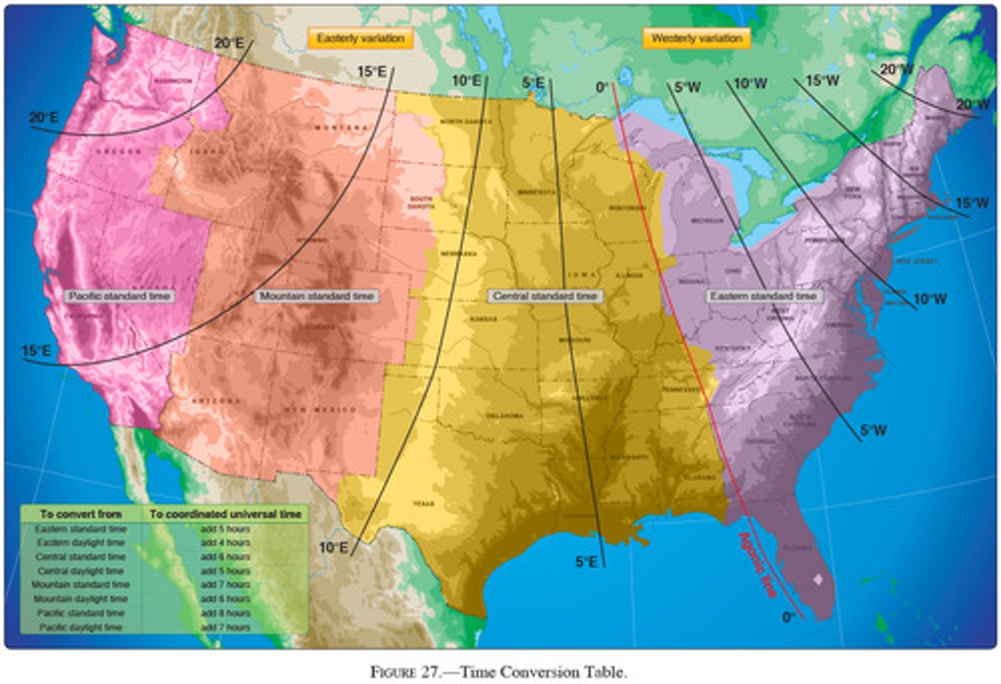
<p>(Refer to Figure 27.) An aircraft departs an airport in the mountain standard time zone at 1515 MST for a 2-hour 30-minute flight to an airport located in the Pacific standard time zone. What is the estimated time of arrival at the destination airport?</p><p><span>A) 1645 PST</span><br><span>B) 1745 PST</span><br><span>C) 1845 PST</span></p>
12
New cards

B) Unmarked balloon on cable to 3,008 feet MSL.

(Refer to Figure 20, area 5.) The CAUTION box denotes what hazard to aircraft?

A) unmarked balloon on cable to 3008 ft MSL
B) unmarked balloon on cable to 3008 ft AGL
C) unmarked blimp hangers at 308 ft MSL
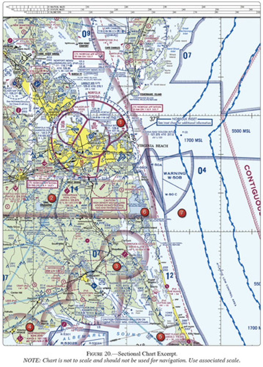
<p>(Refer to Figure 20, area 5.) The CAUTION box denotes what hazard to aircraft?</p><p><span>A) unmarked balloon on cable to 3008 ft MSL</span><br><span>B) unmarked balloon on cable to 3008 ft AGL</span><br><span>C) unmarked blimp hangers at 308 ft MSL</span></p>
13
New cards

C) visual checkpoint used to identify position for initial callus to Norfolk Approach Control

(Refer to Figure 20, area 2.) The flag symbol at Lake Drummond represents a

A) compulsory reporting point for Norfolk class C airspace
B) compulsory reporting point for Hampton Roads Airport
C) visual checkpoint used to identify position for initial callus to Norfolk Approach Control
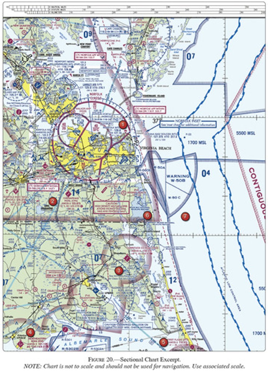
<p>(Refer to Figure 20, area 2.) The flag symbol at Lake Drummond represents a</p><p>A) compulsory reporting point for Norfolk class C airspace <br>B) compulsory reporting point for Hampton Roads Airport<br>C) visual checkpoint used to identify position for initial callus to Norfolk Approach Control</p>
14
New cards

A) 19 ft.

(Refer to figure 20 area 2) the elevation of the Cheasapeake Regional Airport is

A) 19 ft
B) 55 ft
C) 230 ft
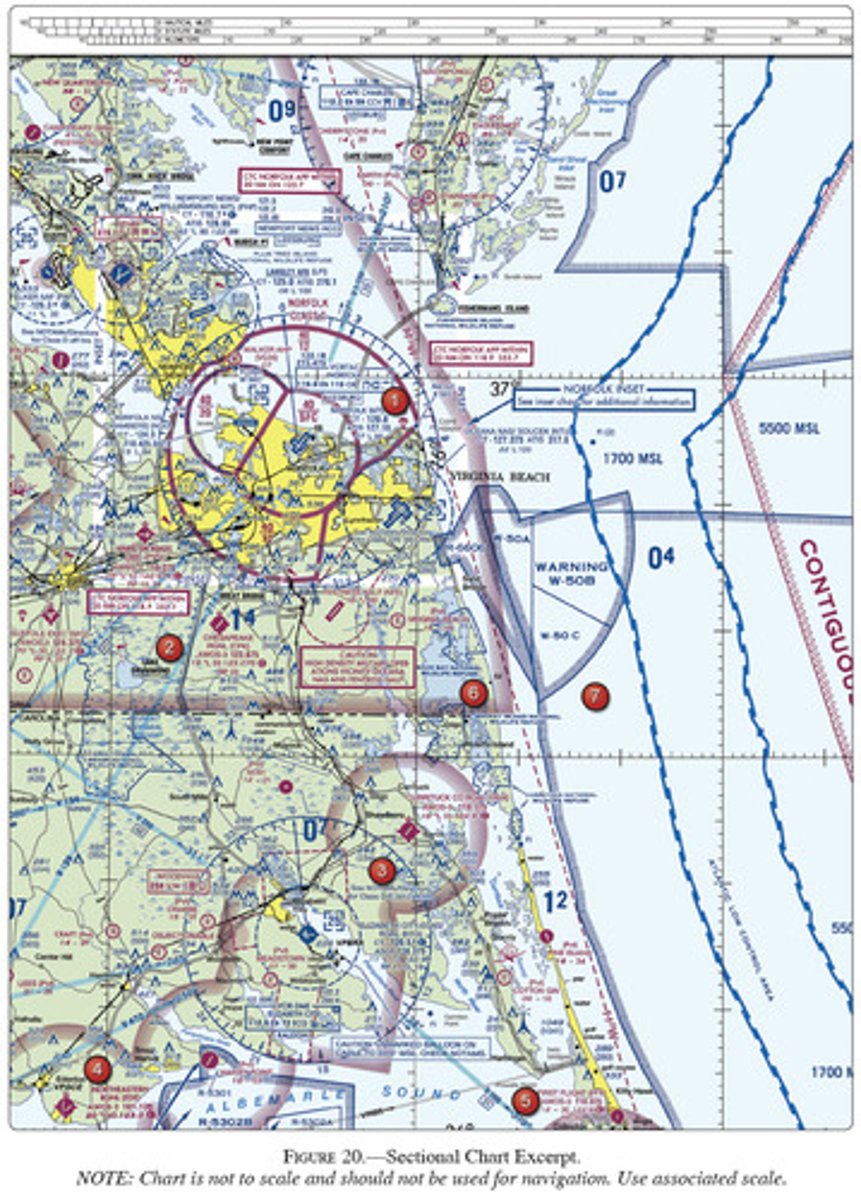
<p>(Refer to figure 20 area 2) the elevation of the Cheasapeake Regional Airport is <br><br>A) 19 ft<br>B) 55 ft<br>C) 230 ft</p>
15
New cards

B) 2,000 feet to 2,500 feet MSL.

(Refer to figure 21) the terrain elevation of the light tan area between Minot and Audubon Lake varies from

A) sea level to 2000 ft MSL
B) 2000 ft to 2500 ft MSL
C) 2000 ft to 2700 ft MSL
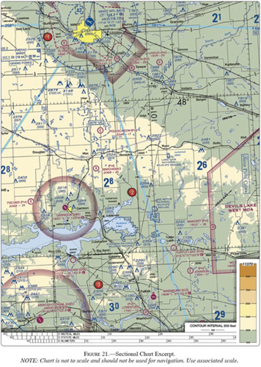
<p>(Refer to figure 21) the terrain elevation of the light tan area between Minot and Audubon Lake varies from<br><br>A) sea level to 2000 ft MSL<br>B) 2000 ft to 2500 ft MSL<br>C) 2000 ft to 2700 ft MSL</p>
16
New cards

B) Minot intl

(Refer to figure 21) which public use airports depicted are indicated as having fuel?

A) Minot intl and Garrison
B) Minot intl
C) Mercer county regional airport and Garrison
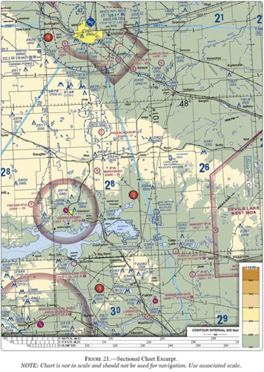
<p>(Refer to figure 21) which public use airports depicted are indicated as having fuel?<br><br>A) Minot intl and Garrison <br>B) Minot intl<br>C) Mercer county regional airport and Garrison</p>
17
New cards

C) visual checkpoints to identify position for initial callup prior to entering Savannah class C airspace
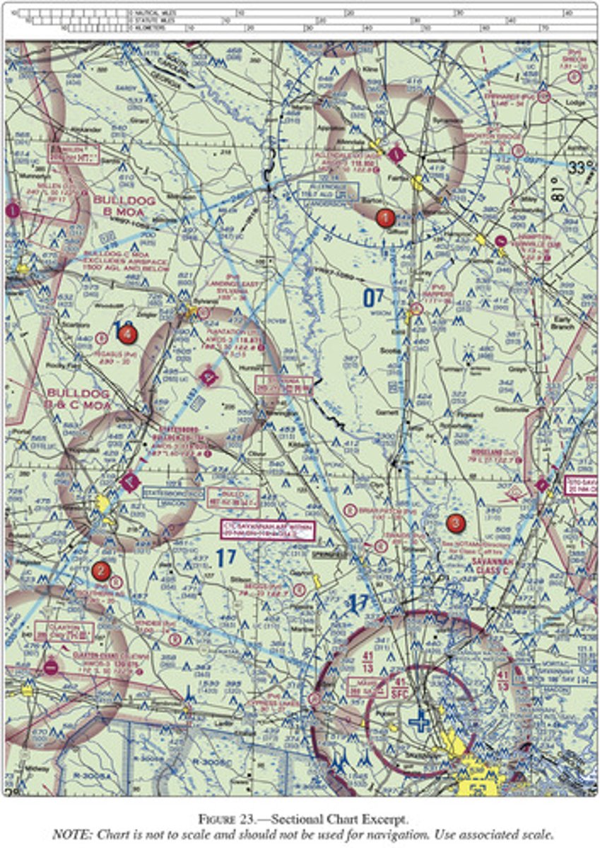
(Refer to figure 23) the flag symbols at Statesboro Bullock County Airport Claxton-Evans County Airport and Ridgewood Airport are

A) outer boundaries of Savannah class C airspace
B) airports with special traffic patterns
C) visual checkpoints to identify position for initial callup prior to entering Savannah class C airspace

<p>(Refer to figure 23) the flag symbols at Statesboro Bullock County Airport Claxton-Evans County Airport and Ridgewood Airport are<br><br>A) outer boundaries of Savannah class C airspace <br>B) airports with special traffic patterns <br>C) visual checkpoints to identify position for initial callup prior to entering Savannah class C airspace</p>
18
New cards

B) 454 feet MSL.

(Refer to Figure 23, area 3.) The top of the group obstruction approximately 11 nautical miles from the Savannah VORTAC on the 007° radial is

A) 400 AGL

B) 454 MSL

C) 432 MSL
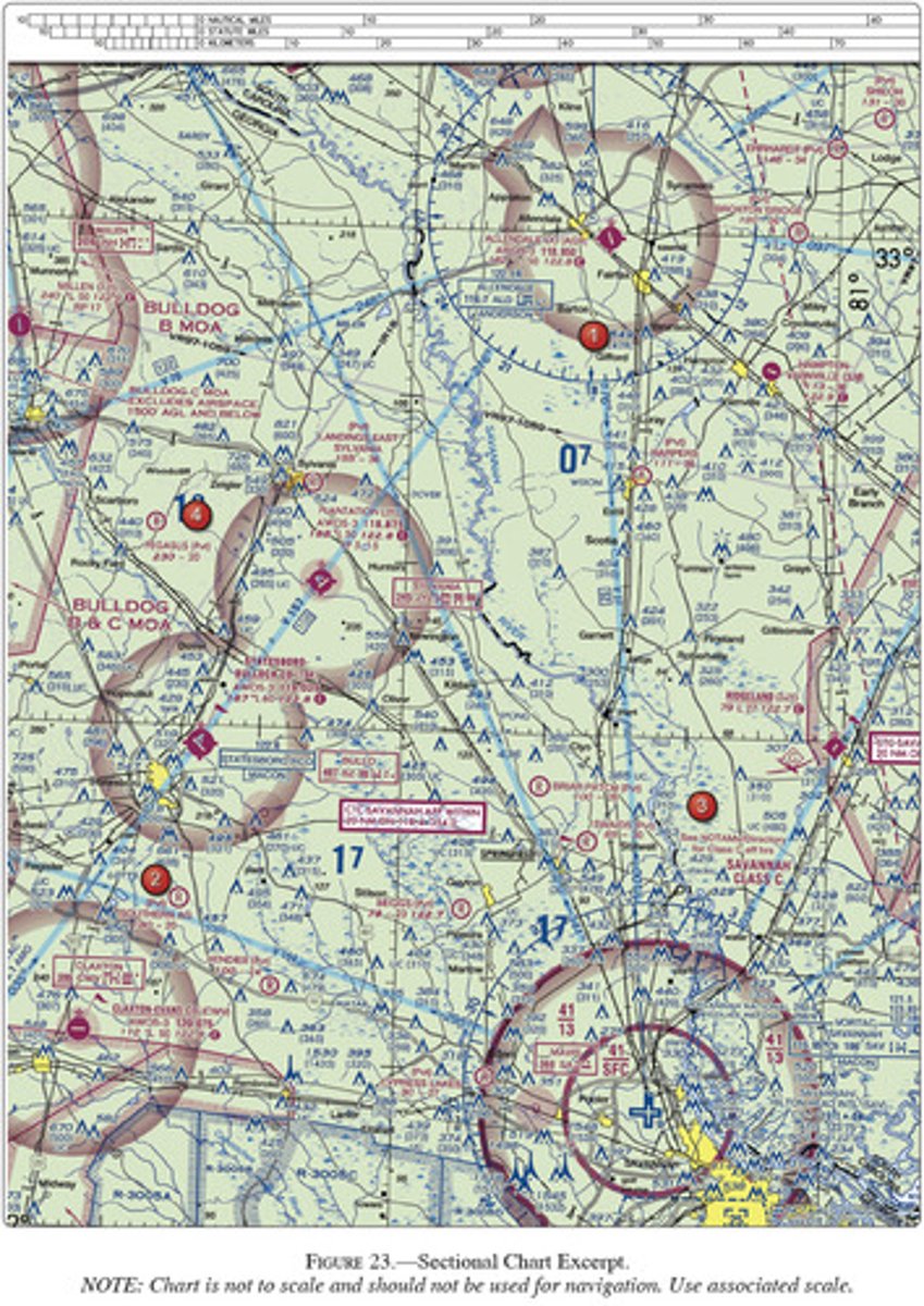
<p>(Refer to Figure 23, area 3.) The top of the group obstruction approximately 11 nautical miles from the Savannah VORTAC on the 007° radial is</p><p>A) 400 AGL<br><br>B) 454 MSL<br><br>C) 432 MSL</p>
19
New cards

B) 1,273 feet MSL.

(Refer to figure 34 area 1) what minimum altitude is necessary to vertically clear the obstacle on the northeast side if Airpark East Airport by 5000 feet?

A) 1010 MSL

B) 1273 MSL

C) 1283 MSL
<p>(Refer to figure 34 area 1) what minimum altitude is necessary to vertically clear the obstacle on the northeast side if Airpark East Airport by 5000 feet?<br><br>A) 1010 MSL<br><br>B) 1273 MSL<br><br>C) 1283 MSL</p>
20
New cards

C) 1,403 feet MSL.

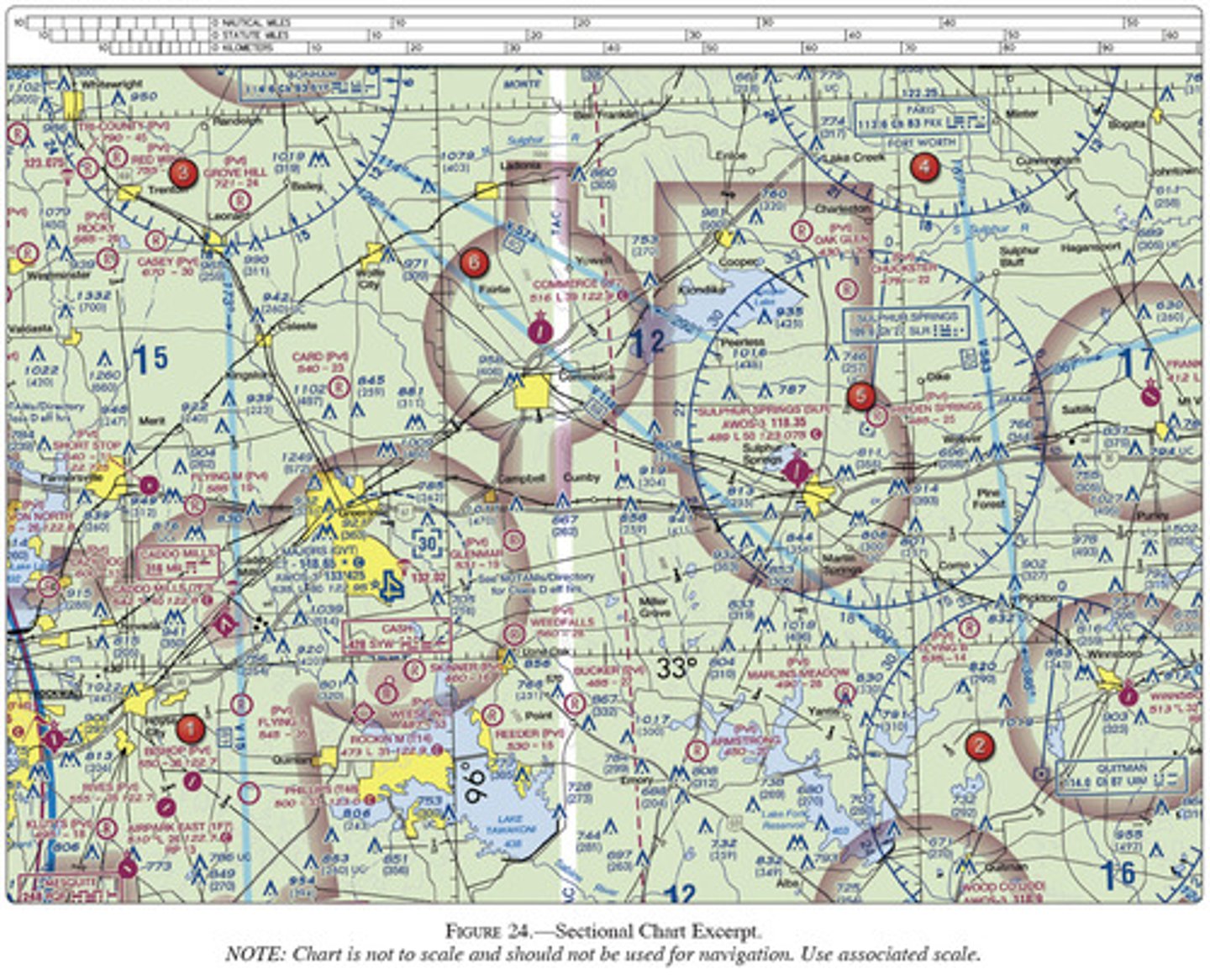
(Refer to Figure 24, area 2.) What minimum altitude is necessary to vertically clear the obstacle on the southeast side of Winnsboro Airport by 500 feet?

A) 823 MSL

B) 1013 MSL

C) 1403 MSL
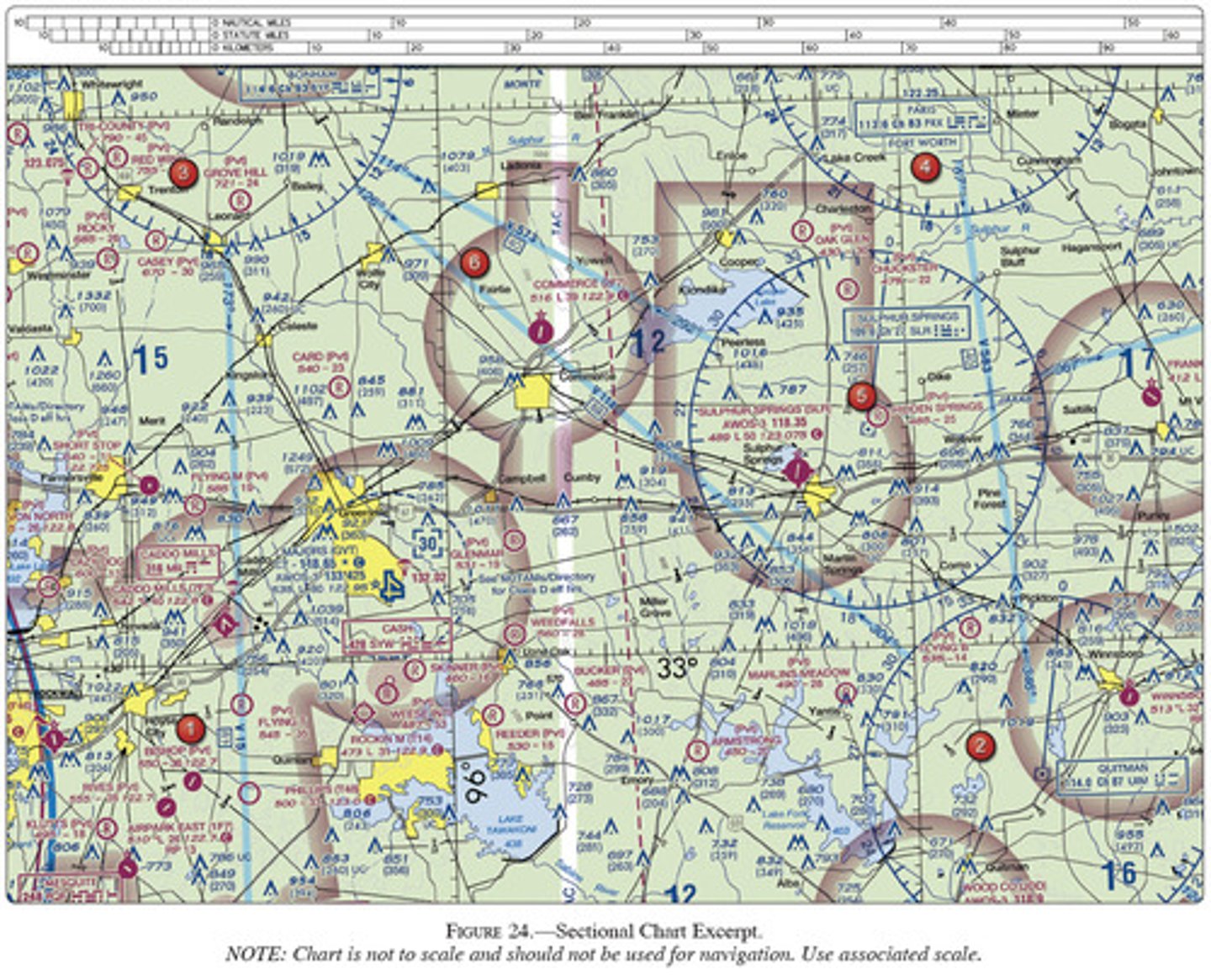
<p>(Refer to Figure 24, area 2.) What minimum altitude is necessary to vertically clear the obstacle on the southeast side of Winnsboro Airport by 500 feet?</p><p>A) 823 MSL<br><br>B) 1013 MSL<br><br>C) 1403 MSL</p>
21
New cards

A) 126.0 MHz.

(Refer to Figure 25, area 2.) The control tower frequency for Addison Airport is

A.126.0 MHz.
B.133.4 MHz.
C.122.95 MHz.
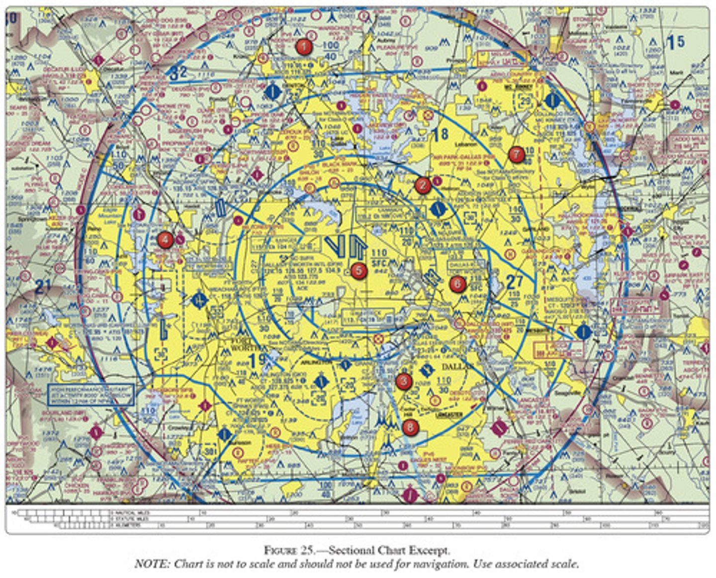
<p>(Refer to Figure 25, area 2.) The control tower frequency for Addison Airport is</p><p><span>A.126.0 MHz.</span><br><span>B.133.4 MHz.</span><br><span>C.122.95 MHz.</span></p>
22
New cards

B) 3,549 feet MSL.

(Refer to Figure 25, area 8.) What minimum altitude is required to fly over the Cedar Hill TV towers in the congested area south of NAS Dallas?

A) 2655 ft MSL

B) 3549 ft MSL

C) 3449 ft MSL
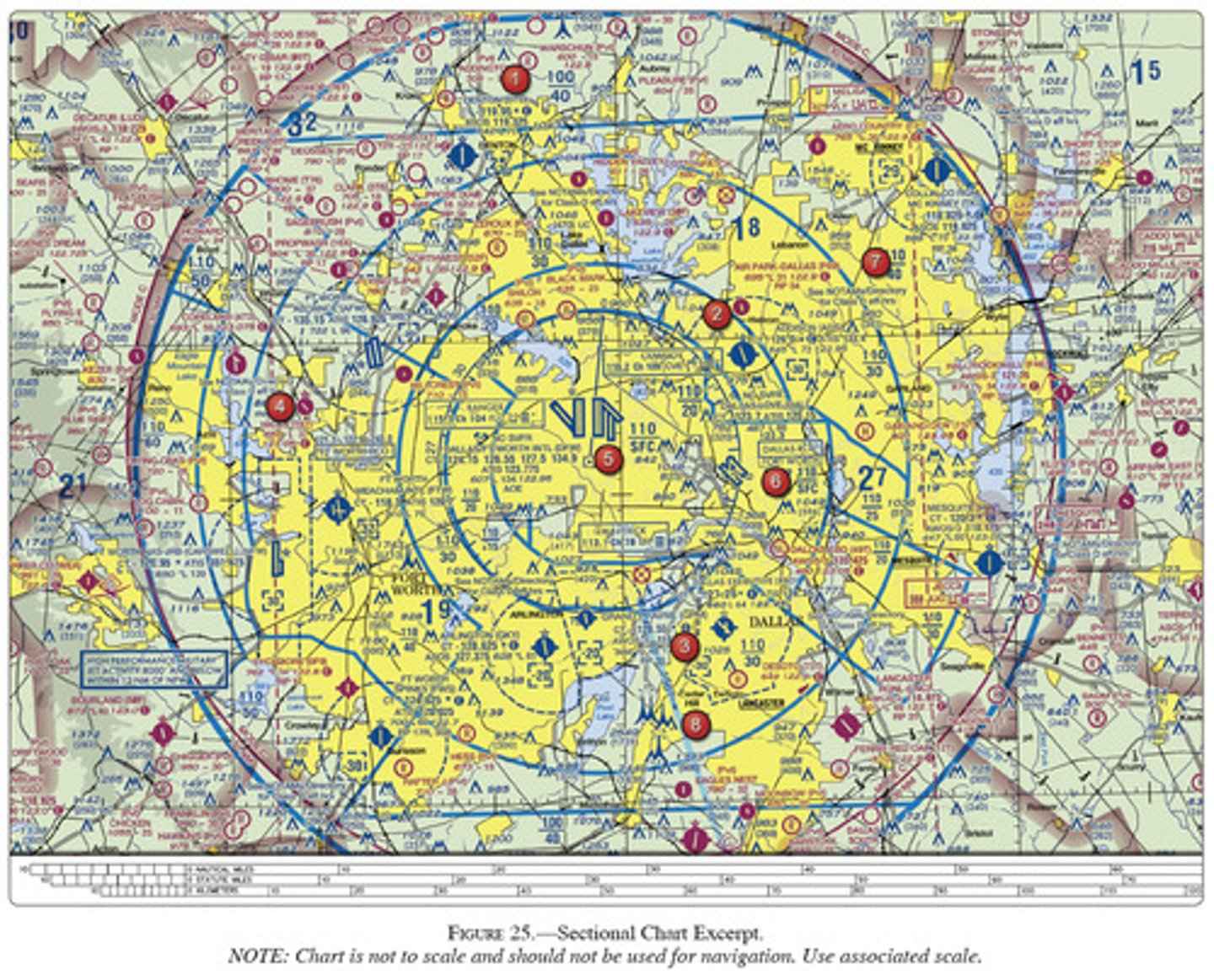
<p>(Refer to Figure 25, area 8.) What minimum altitude is required to fly over the Cedar Hill TV towers in the congested area south of NAS Dallas?</p><p>A) 2655 ft MSL<br><br>B) 3549 ft MSL<br><br>C) 3449 ft MSL</p>