Coasts
1/39
There's no tags or description
Looks like no tags are added yet.
Name | Mastery | Learn | Test | Matching | Spaced |
|---|
No study sessions yet.
40 Terms
What is a coast
The zone where land meets sea
What is the littoral zone
The wider coastal zone including adjacent land areas and shallow parts of the sea just offshore
The structure of a coast
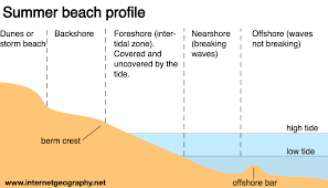
back shore - usually above influence of waves. only exposed to waves under spring tide or storm surges during extreme weather events.
Foreshore - the zone between the upper limit of HT and LT, the intertidal zone
Nearshore - (breaker zone) extending beyond where waves break. shallow water close to land. most human activity happens hurter e.g. fishing
Offshore - out at sea, beyond influence of waves
What is an estuary, dynamic equilibrium and high/low energy
An estuary is where river meets sea, tidal.
Dynamic equilibrium - the coast is in it, input and output happening at the same rate. e.g. erosion and deposition. if the uk was left naturally this would be the case but human intervention with sea defences has prevented this.
high energy - erosion, cliffs
low energy - deposition, sandy, dune, salt marsh.
concordant vs discordant
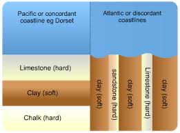
concordant - different rock types are parallel to the coastline e.g Dalmatian coast
discordant - different types of rock are perpendicular to coastline. e.g Isle of Porpecu
Erosion, Weathering, transportation
erosion
abrasion - waves throw sand/pebbles at cliff
hydraulic action - forces of waves hitting at cliff
attrition - pebble on pebble action
solution - rocks dissolve e.g limestone
weathering
biological
mechanical (freeze-thaw)
chemical - slightly acidic rain
transportation
saltation - sediment bounces along due to forced of water or wind
traction - sediment rolls along pushed by waves and currents
suspension - sediment is carried in the water column
solution - dissolved material is carried in the water
CCASS at headland
cave gets bigger through hydraulic action and reaches other side to make an arch. Through gravity and weathering the top of the arch collapses leaving a stack. Then a fault appears on the stack and leaves a stump.
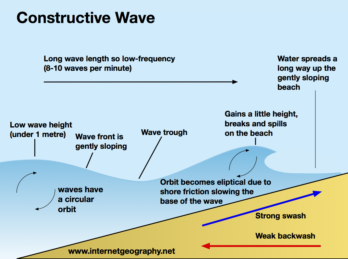
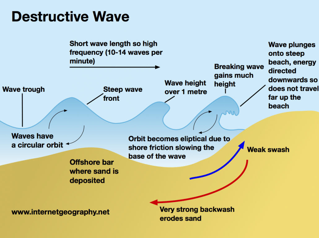
constructive and destructive waves
waves are cause by wind, energy moves in a wave
fetch is the distance waves/wind travel
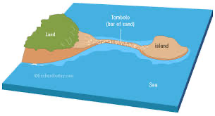
creation of spits, bars and tombolos
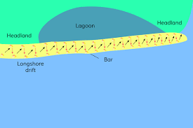
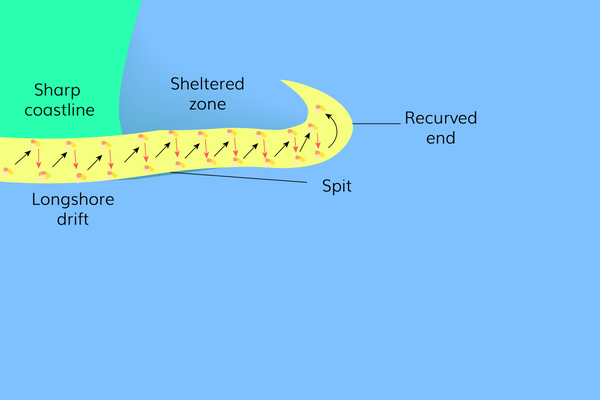
recurved, hooked and double spits caused by secondary wind.
creation of barrier beach and cuspate forelands
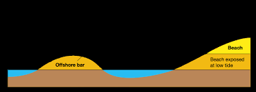
destructive waves mean backwash drags sediment to a pile called an offshore bar, if sediment pile reaches surface it forms a barrier island and a new coastline is created. e.g Holland coastline, concordant features

Dungeness. was a spit with mudflats and a slat marsh behind it. Humans drained it to build settlements. The River Rother broke through the middle of the spit and the spit has become wider. then a big storm moved the river and cut off the spit and the spit keeps growing through long shore drift and deposition.
creation of sand dunes and salt marshes/mud flats
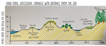
Psammosere - sand dune series, pioneer species is marram grass. Halosere - saltwater series, pioneer species is eelgrass, happens in mud flats and salt marsh, river mouth, clay deposited by suspension.

flocculation - clay particles clump together and settle out when fresh water meets salty sea.
sediment cell
sediment moves along the coast in cells. within cells, the sediment moves between the beach, cliffs and sea through the process of erosion, transport and deposition. any action taken in one place has an impact elsewhere in the cell. sediment cells are in a dynamic equilibrium with sources, transfers and sinks.
subaerial processes (weathering and mass movement)
freeze-thaw - water expands by about 10% when it freezes which will exert pressure on water that freezes in cracks and fissures in rocks, eventually breaking them. salt crystallisation - sea water in cracks evaporates and salt crystals crack the rock as they exert pressure.
chemical - carbonation, limestone dissolves in slightly acidic rainfall, rainfall absorbs co2. hydrolysis, feldspars turn into clay. presence of water with dissolved co2 changes chemical structures of minerals. oxidation, when addition of oxygen makes iron oxides and breaks down minerals (rust)
biological - plants roots grow in cracks and force them to grow bigger. water running through decaying vegetation is acidic, increases chemical weathering. birds and other animals burrowing into cliff faces for shelter.
rockfall - blocks of rock falling, talus scree slope is a pile of rocks.
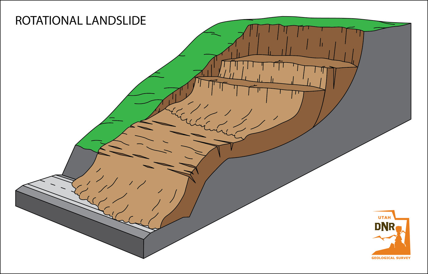
rotational landslide/slump - leaves a rotational scar and a terrace to leave a terraced cliff profile.
flow - mud flow of mud or clay.
Eustatic change, 3 types of submergent landforms
During ice age water from the sea is trapped in ice caps/glaciers so sea level falls. after ice age ice melts so sea level rises. eustatic change is you see the sea level change.
Dalmation coast - sea level rise flooded the valleys.
Fjords - flooded glacial valley
Ria - flooded river valley
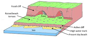
isostatic change, emergent landforms
during ice age the mass of ice pushes land down and pushes the crust into the mantle. This is called subsidence. After ice age land readjusts due to lack of weight, this is called post-glacial adjustment. This is isostatic change (land moving)
other causes of sea level change: subsidence and accretion, and tectonics
subsidence - mass pushes land down. land is getting higher but mass of sediment pushes land down so it stays the same due to dynamic equilibrium. accretion - deposits sediment.
tectonics - tsunamis at destructive plate boundary.
human cause of sea level change, high risk areas
global warming causes sea level rise as it leads to ice caps melting and thermal expansion which is that warmer water has a bigger volume.
high risk areas - Beijing, Shanghai, Bangladesh, Netherlands and Florida.
Kiribati case study
Atoll island
president of Kiribati has bought 20km² of land in the Fijian Islands so people can move there when country disappears. only 1m above sea level and are coral atolls. probably underwater within 50 years. waves are going over sea wall, sea defences are not working. people had to move repeatedly. road has been eroded and storm surges have contaminated drinking water. solutions are rainwater collection and planting mangroves which break the waves to ry and catch sediment. also not taking sand from the beach. population is 120,000
Holderness coast geology
fastest eroding coastline
Holderness is made of boulder clay which is really weak and makes shallow cliffs easy to erode
Holderness coast fetch, long shore drift and sub aerial processes
fetch
500-800km
sea floor is deep so waves reach cliffs without first being weakened by friction
long shore drift
travelling to the south
very narrow beach
sub-aerial process
freeze-thaw weathering
How humans effect holderness coast
residents and farmers are stakeholders who want it to be protected.
terminal groin syndrome - groins in Hornsea mean the beach is starved of sediment further south along the coastline
Why is Bangladesh at risk of flooding
lies on floodplain of 3 different rivers
Himalayan snow melt
low lying
removal of vegetation like mangroves
climate (monsoon seasons)
storm surge
high population density
how are humans increasing this risk
subsidence
interrupts flow of sediment
needs mud
Bangladesh naturally sinking
Removing vegetation
collects water and sediment (mangroves)
mangroves resist waves so are a natural sea defence]
deforestation for farming rice
Bangladesh cyclone Siar 2007
6m storm surge
salt water ruined crops
685,000 hectares of damaged crops
1,518,000 damaged houses
55282 people injured
4234 people dead/missing
1,778507 cattle and poultry killed
16,954 schools damaged
8075km roads damaged
703km of electricity lines ruined
total cost of damage was $1.7 billion
2013/1953 storm surge in UK
intense low pressure caused storm surges
1953 killed 307 people in UK and 1800 people in Netherlands
2 people died in 2013 storm
long shore drift was south, storm went from north to south down North Sea
North Sea gets narrower and shallower as it goes south (funnel effect) which made surge higher
high tide
strong northernly winds pushed storm south and increased surge
2013 less died due to more knowledge, prediction and preparation. had barriers.
Hard engineering 1. groynes
made from timber or rock and built at 90 degrees to coast. works by trapping sediment being moved along the coast by LSD which builds up the beach.
Advantages - built up beach increases tourist potential and protects land behind it. natural and not too expensive.
disadvantages - groynes starve beach further along and leads to increased erosion known as terminal groin syndrome. they are also unnatural and unattractive.
cost - £5000 -£10,000 each
one of most common in urban areas
HE 2. sea walls
made from stone or concrete at the foot of cliff or on top of the beach. works by reflecting waves back into the sea
Advantages - effective prevention of erosion. often have a promenade on top for people to walk on which is good for tourism.
disadvantages - reflect wave energy rather than absorbing it. can be intrusive and unnatural. very expensive.
cost £6000 a metre
one of most common in urban areas
HE 3. rip rap/rock armour
made from large rocks being placed at foot of a cliff or top of a beach. works by forming a permeable barrier to the sea and breaks up waves but allows some water to break through so it absorbs wave energy.
advantages - relatively cheap and easy to construct and maintain. often used for fishing or sunbathing.
disadvantages - usually rocks from somewhere else so don’t fit in with local geology and can be intrusives and rocks can be dangerous for people who go to beach.
costs £100,000-300,000 for 100m
HE 4. revetments
made from sloping wooden, concrete or rock structures being placed at the foot of a cliff.
works by breaking up wave energy
advantages - relatively inexpensive to build
disadvantages - intrusive and unnatural. needs high levels of maintenance.
costs up to £4500 a metre.
HE 5. offshore breakwater
made from partly submerged rock barrier. works by breaking up wave energy before they reach the coast.
advantages - effective permeable barrier
disadvantages - visually unappealing and a potential navigation hazard.
costs similar to rock armour depending on material.
Soft engineering 1. beach nourishment
works by adding sediment to make beach higher or wider. sediment is usually dredged from seabed.
advantages - relatively cheap and easy to maintain. looks natural and blends in. increases tourist potential.
disadvantages - needs constant maintenance because of natural processes.
costs £300,000 for 100m
on of most common in urban areas
SE 2. cliff regrading and drainage
works by reducing the angle of a cliff to help stabilise it. drainage removes water.
advantages - regrading can work on clay or loose rock where other methods don’t work. drainage is cost effective
disadvantages - regrading can cause cliffs to retreat. drainage can dry out and lead to collapse.
SE 3. dune stabilisation
works by planting marram grass to stabilise the dunes and placing fences to keep people off newly planted dunes.
advantages - maintains natural coastal environment and provides important habitats. relatively cheep and sustainable.
disadvantages - time consuming to plant. people may respond badly to being kept off certain areas.
costs £200-2000 for 100m
SE 4. marsh creation
works by allowing low lying coastal areas to be flooded to let land become salt marshes.
advantages - relatively cheap and a natural defence so not intrusive
disadvantages - agricultural land lost
cost depends.
ICZM (integral coastal zone management)
this process brings together all stakeholders involved in development, management and use of the coastline (businesses, tourists)
aim is to establish sustainable levels of economic and social activity, resolve environment, social and economic challenges and conflicts.
means that complete sections of coast are now being managed as a whole rather than by individual towns as we know human activity in one place effects the other. known as holistic management.
SMP (shoreline management plan)
uk version of ICZM. SMPs are based on sediment cells (a unit of coastline between two points with processes in between). they are used on sediment cells because an action in one part if the sediment cell will affect another part. this means that any protection built will have an affect further down, possibly leading to terminal groyne syndrome.
environmental agency (government) are responsible for making the plan and building the defences and using taxes to pay.
local government are responsible give planning permission and represent local people.
stakeholders in the economy (farmers, shops, hotel and gas) effected by coast will have a say.
environmental stakeholders are groups in the community who have a say like national trust
4 policies of SMP: 1. Hold the line
involves maintaining the current position of the coastline
most common in urban areas
high value land use this method
e.g seaford have beach replenishment, groin and sea wall
often a mix of hard and soft engineering
Advance the line
involves expanding coastline out to sea
historic method that is not so common now
e.g. Hastings built on the wave cut platform to extend it out
could be salt marsh drainage with embankments to increase land space for farming
managed retreat/strategic realignment
allows coastline to retreat but in a managed way
very rare
case study at a farm in Essex that destroyed embankments to allow the salt marsh to regenerate as it attracts birds which creates tourism opportunities.
do nothing/ no active intervention
involves letting nature take its course and allowing erosion
mostly at important geographical places e.g. jurassic coast or at low value land e.g. holderness coast.