glaciated landscapes - knowledge
1/140
There's no tags or description
Looks like no tags are added yet.
Name | Mastery | Learn | Test | Matching | Spaced | Call with Kai |
|---|
No study sessions yet.
141 Terms
What % of earth is covered by glaciers
10%
When was the last glacial maximum
21,000 years ago, 32% of these earth was covered
Ice cap v ice sheet
<50,000 km² (vakaajokull, Iceland) = ice cap
>50,000km² (Greenland, Antarctica) = ice sheet
Where is freshwater stored
90% stored in cryosphere
What happens if all ice melted
Sea level rise by 70 m
What’s the cryosphere
All frozen parts of the planet
Inputs - open glacial system
Energy - thermal (sun), kinetic (movement of the glacier) and potential (position on slope)
Matter - snowfall (precipitation), avalanching, wind deposition (wind blown snow), debris from mass movement and weathering
Outputs - open glacial system
Energy - thermal (e.g. evaporation)
Matter - meltwater, ice (carving of iceburgs into lakes/oceans), evaporation, sublimation and debris
Throughputs - open glacial system
Stores - ice, water and debris
Flows - ice, water and debris
Positive balance
Glacier is gaining mass (normally during the winter)
Negative balance
Glacier is losing mass (during the summer)
Dynamic equilibrium
A glacier system in equilibrium where inputs (accumilation) = outputs (ablation) - self regulated
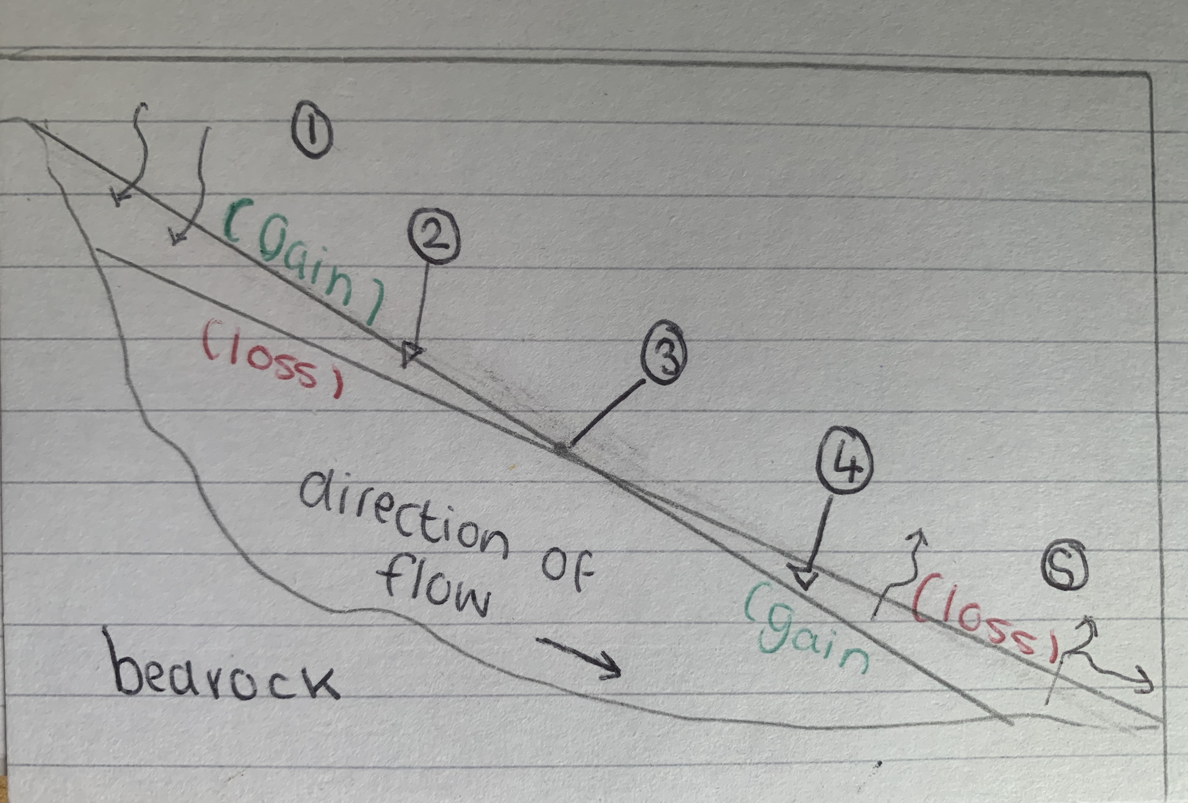
Glacier mass balance
Accumilation zone
Positive balance
Equilibrium line
Negative balance
Ablation zone
How does glacial ice form
New snow compresses and compacts the layer beneath, air is removed - low density snow now high density
Known as diagenesis, takes 40-1000 years
True glacial ice found around 100m down, very pure blue colour
Valley glaciers (warm based)
Confined by valleys, follow course of river valley
May be outlet glaciers from ice sheets or fed by Corrie glaciers
10-30km long
Alps, rockies and Andes
Ice sheets (cold based)
Accumilation extending more than 50,000km²
96% of world ice, only found in Antarctica, Greenland (thickest ice 4,700 m)
Ice sheets previously covered most of Europe
Warm based glacier
High altitude locations, steep relief
High accumulation and ablation
Basal temperatures at or near pressure melting point
Melt water created as temperatures reach pressure melting point at base of ice
Rapid rates of movement – mobile glacier = erosion (20-200m/year)
Basal slippage occurs
Cold based glacier
High latitude locations with low relief
Ablation and accumulation is limited
Basal temperatures below pressure melting point (no melt water and basal slippage)
Glacier is frozen at the bed, therefore little movement and little erosion or deposition
Slow rates of movement, temperatures below 0°
Internal defamation
Glacial budget - influencing glacier movement
A positive budget (net accumulation) causes the glacier to advance
Gravity - influencing glacial movement
Fundamental cause of movement of an ice mass
Gradient - influencing glacier movement
The speed of the gradient of the grand surface, the faster the ice will move if other factors are excluded
Thickness of ice - influencing glacier movement
Influences basal temperature and the pressure melting point
Internal temperature- influencing glacier movement
Allow movements of one area of ice relative to another
Internal deformation - Latimer flow
Movement of each layer within the glacier
Will occur faster depending on the gradient and position of the glacier
Inter-granular flow - internal deformation
Individual grains of ice slip, move in relation to each other, re-orienting themselves
Internal deformation- example
Moves 3-4 M/year at its equilibrium line, 100% of this is movement
Where is Latimer flow found
Cold based glaciers
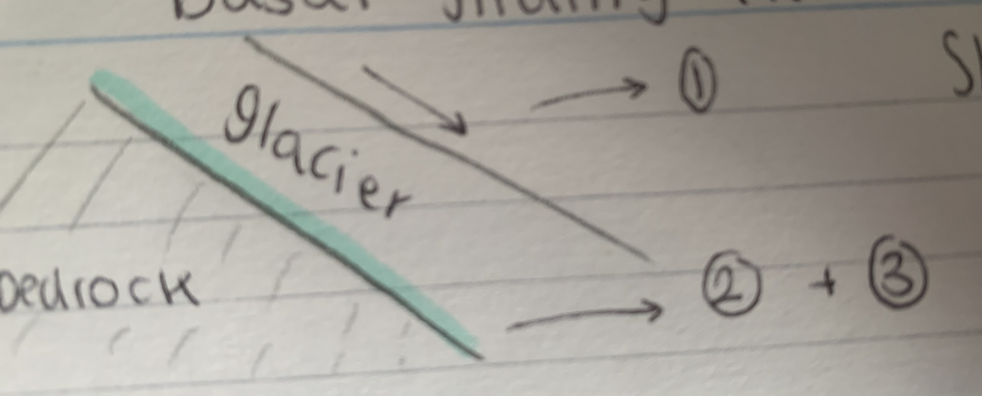
Where is basal sliding
Warm based glaciers
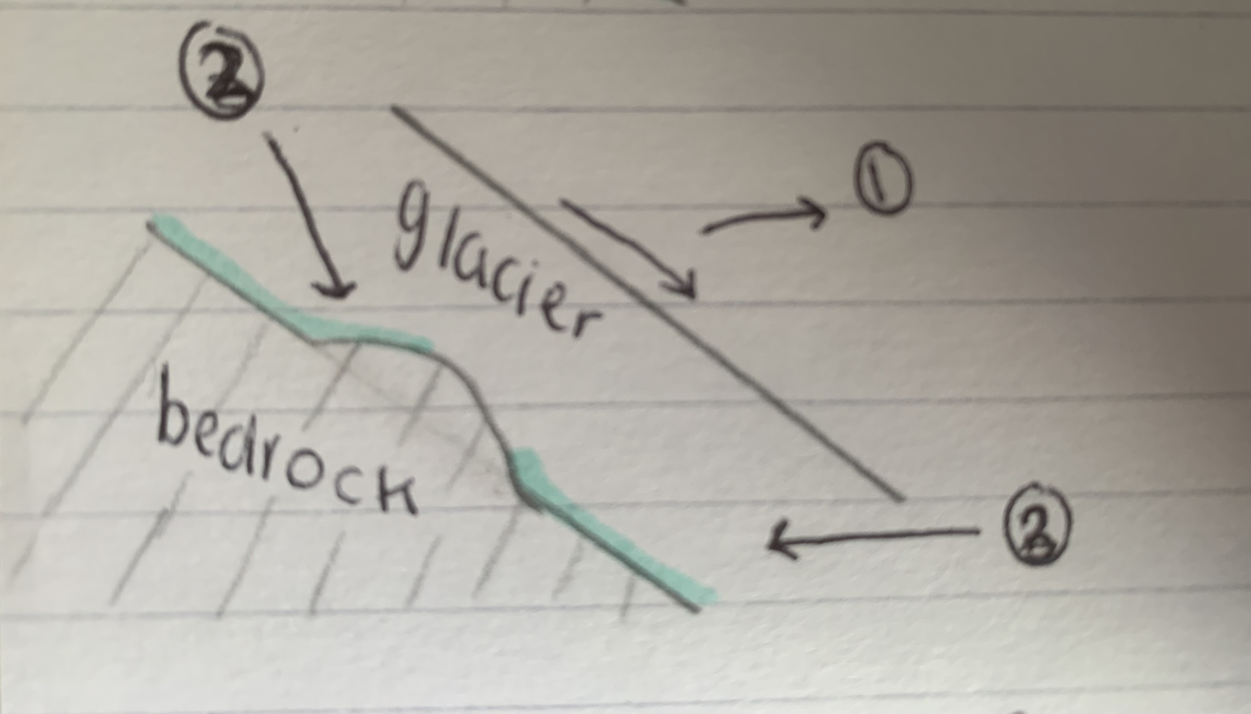
Creep and regelation - basal sliding
Direction of movement due to gravity
Pressure build up, causes localised pressured melting
Ice deforms under the pressure, spread around block ‘plasticly’
Meltwater flows around the block then refreshes when normal pressure returns
Slippage - basal slippage
Direction of movement due to gravity
Reduces friction between base of glacier and bedrock
Friction creates meltwater, as it reaches pressure melting point, allowing it to move more
Bed deformation - basal sliding
Direction of movement due to gravity (gentle gradient)
Carry’s the ice by saturated bed sediments, water under high pressure
Referred to as on ‘ ice skates ‘
Examples - basal sliding
Franz josef, New Zealand - moves 300 M/year, warm based
Salman, Canada - 45% of movement due to basal sliding, could be up to 90%
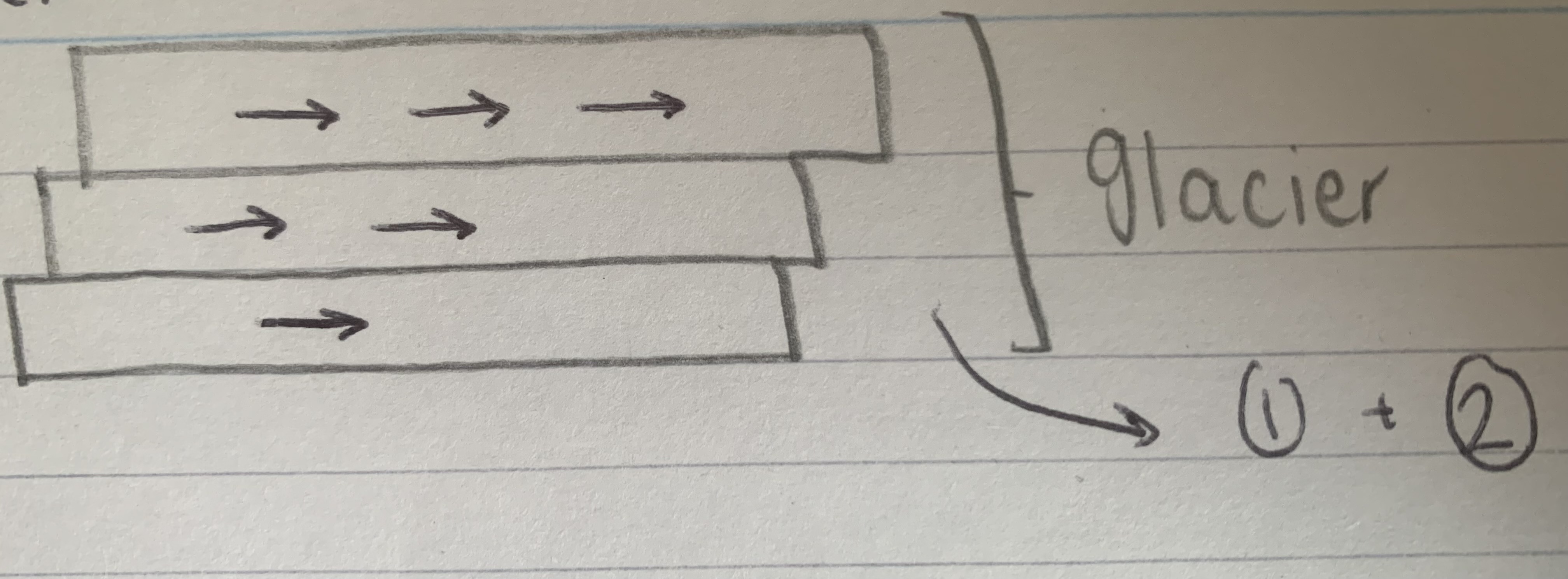
Extending flow
When ice moves down a slope quickly, fractured ice accelerates forward becoming thinner
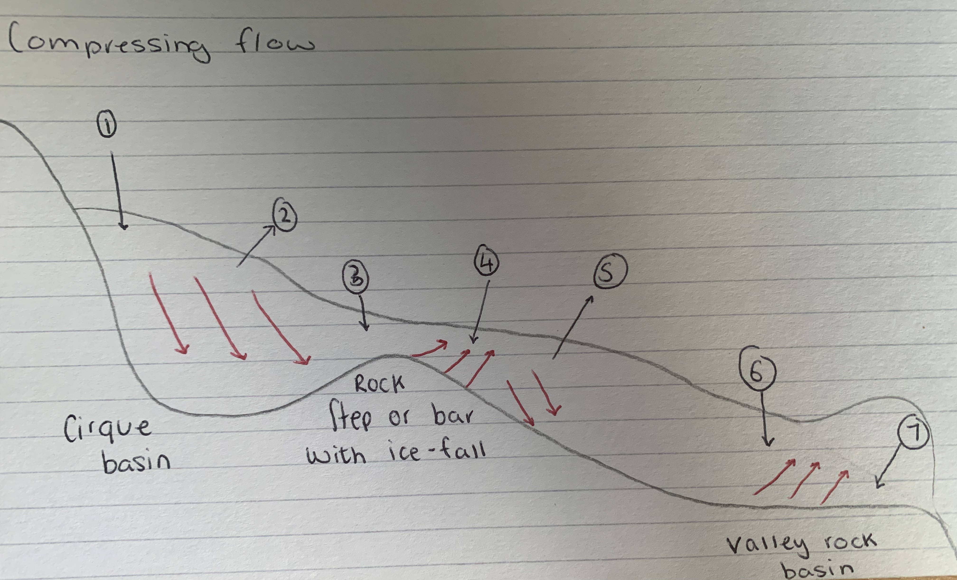
Compressing flow
When the gradient is reduced, the ice slows and becomes thicker
Extending and compressing flow
Extending flow, Bergschrund and Crevasses
Slip plane
Compressing flow
Extending flow, Crevasse and Seracs (ice blocks or steep faults)
Surface of ice breaks and cracks because of higher velocity
Compressing flow
Pressure bulges as compressing flow begins
Wind - physical factors influencing landscapes
Erosional, transportation, deposition - a moving force
Acts upon fine material deposited by ice or meltwater
Precipitation amount - physical factors influencing landscapes
Main Input of snow, sleet and rain
High Lattitude = precipitation may be low
High altitude = high precipitation
Antarctica means precipitation = 4.5 mm/year
Structure of geology - physical factors influencing landscapes
Properties of rock types, jointing, bedding and faulting
Angles of rocks influences valley profiels and permeability of rock type
Latitude - physical factors influencing landscapes
High Lattitude have cold dry climates with low variation in precipitation
Altitude - physical factors influencing landscapes
High altitudes have higher precipitation but, higher temperatures = more melting
Relief - physical factors influencing landscapes
Steeper the relief, the greater fource of gravity = more energy for a glacier to move down the slope
Aspect - physical factors influencing landscapes
Face away from the sun = low temperatures and melting (below 0c for longer) - opposite for facing toward the sun
Will effect the mass balance and the shape of the landscape
Lithology of geology - physical factors influencing landscapes
Physical and chemical composition of rocks
More strong rocks are resistant to erosion, weaker are vulnerable to decay (at low temperatures)
Strong rocks form glaciated landscapes (arêtes, pyramidal peaks)
Temperature - physical factors influencing landscapes
If temperatures above 0c ice will start to become a output system
High altitude have significant areas 0c + temperatures
High Lattitude temperature doesn’t really rise above 0c
Seasonal distribution of precipitation - physical factors influencing landscapes
Jasper, precipitation = 25mm in January (snow), 100mm in June (ice)
Little seasonal change in Antarctica
Greater seasonal change, more varied mass balance
Geomorphic process
Rock changing processes
Weathering - geomorphic processes in landscapes
Decay and disintegration of rocks at or near the earths surface
Mass movement - geomorphic processes in landscapes
Forces acting on a slope material exceed forces trying to keep the material on the slope
Most significant on steep slopes
Adds debris to glaciers providing a tool for abrasion
Erosion - geomorphic processes in landscapes
Occurs as glaciers advance in upland areas
Deposition - geomorphic processes in landscapes
Glaciers deposit when there capacity to transport the material is reduced
All deposits are known as drift
Divided into till (material from ice)
And outwash (material from meltwater)
Transportation- geomorphic processes in landscapes
Divided into supraglacial, englacial and subglacial
Freeze-thaw - physical weathering
Water enters cracks and expands by 10% when it freezes, causes pressure causing rock to split
More frequent fluctuations in temperatures around 0c = more effective
Frost shattering - physical weathering
At low temperatures water trapped in pores freezes and expands
Creates stress and rock disintegrates to small pieces
Pressure release - physical weathering
Weight of overlaying ice in a glacier is lost due to melting
Underlying rock expands and fractures Parallel to the surface
Significant as granite is known for its strength
The parallel fractures are called pseudo-bedding planes
Other bits for physical weathering
Temperature may stop these processes
No chemical alteration occurs
Oxidation - chemical weathering
Some minerals in rocks react with oxygen (in air or water)
Iron is susceptible to this and becomes soluble under extremely acidic conditions and the structure is destroyed
Often attacks iron-rich sediments that bind sand grins together in sandstone
Carbonation - chemical weathering
Water combines with dissolved carbon dioxide which reacts with calcium carbonate in rocks (limestone) to make calcium carbonate (solvable)
Solution - chemical weathering
Salts are solvable in water, iron is only solvable in acidic water PH3
Any process where mineral dissolves in water is known as solution - there are mineral specific processes
Other information for chemical weathering
Water contacts rock and dissolves some of the minerals in the rock
Chemical reactions happen when temperatures increase - 10c increase leads to 2.5x increase in reactions
Rain/snowfall can become slightly more acidic
Tree roots -biological weathering
Grow in cracks and places pressure
Many expose rocks and make them susceptible to weathering
Organic acids - biological weathering
Produced during decomposition causing soil water to become more acidic and react with minerals (chelation)
Blue-green algae produces a shiny film of iron and magnesium oxide on rocks
Other bits - biological weathering
May be affected by low temperatures so may have limited significance
Rock fall - mass movement
Slopes of 40 degrees +, rocks may become detached through physical weathering, can happen in minutes to seconds
Fall to the foot of the slope under gravity
Transport processes may remove this/can axumilate as a straight, lower angled scree slope
Slides - mass movement
May be linear with movement along a slip plane (fault/bedding) are also known as slumps
May occur due to steeping or undercutting of valley sides due to erosion at the base of the slope under gravity (adding to the downslope fources)
Common in weak rocks (clay) which becomes heavier when wet, adds to downslope forces
Other bits - mass movements
Forces acting on a slope, material exceed forces keeping material up
Most significant on steep slopes
Adds debris to glaciers providing a tool for abrasion
Other bits - erosion
Occurs as glaciers advance in upland areas

Plucking - erosion
Happens when meltwater is in joints in the rocks of the valley floor
Freezes and attaches to the glacier, as moves pulls the rock with it
Effective at base of glacier as weight of ice may produce meltwater
Significant when bedrock is highly jointed (allows water in)
Known as quarrying
Plucking - erosion
Meltwater enter crack in the water
Meltwater freezes and separates rock from bedrock
As the glacier moves the block of rock freezes to the ice and is ‘plucked’ out
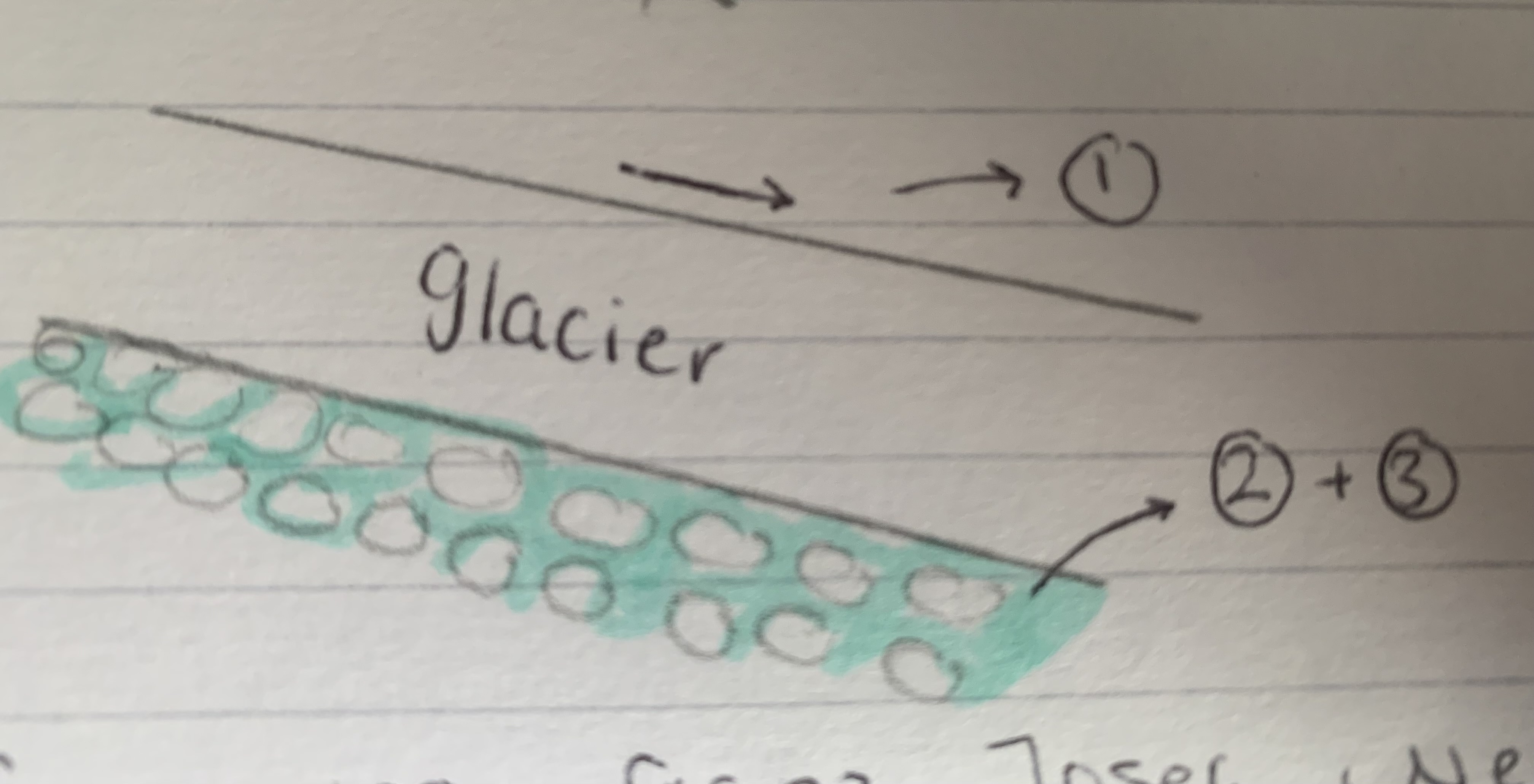
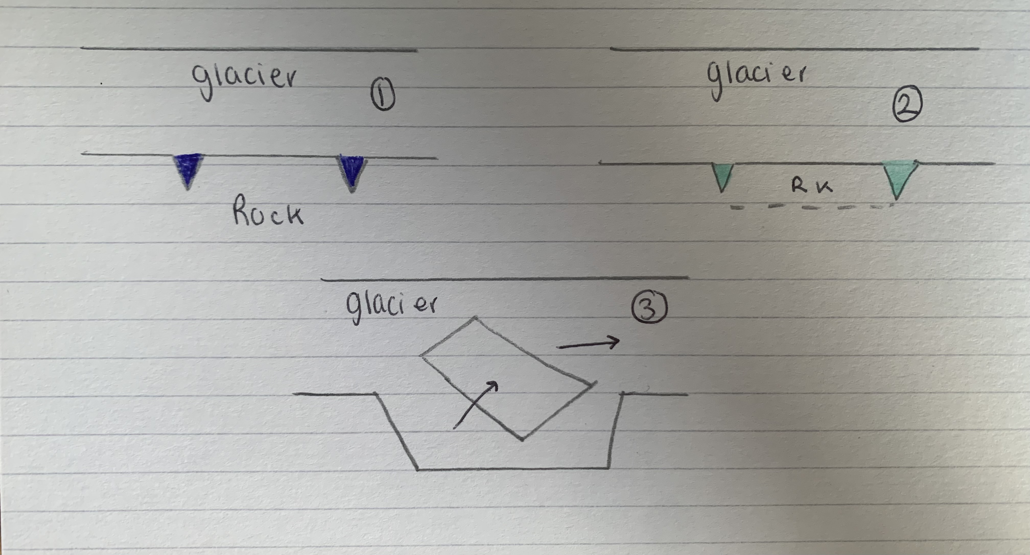
Abrasion - erosion
When the glacier moves, debris embedded in the side which scours the surface rocks, wearing them away (like sandpaper)
The debris is course will scrape, scratch and grove the rock
The fine material will smooth and polish the rock
Debris will go fine creating rock flour which is responsible for the white look glacier meltwater streams
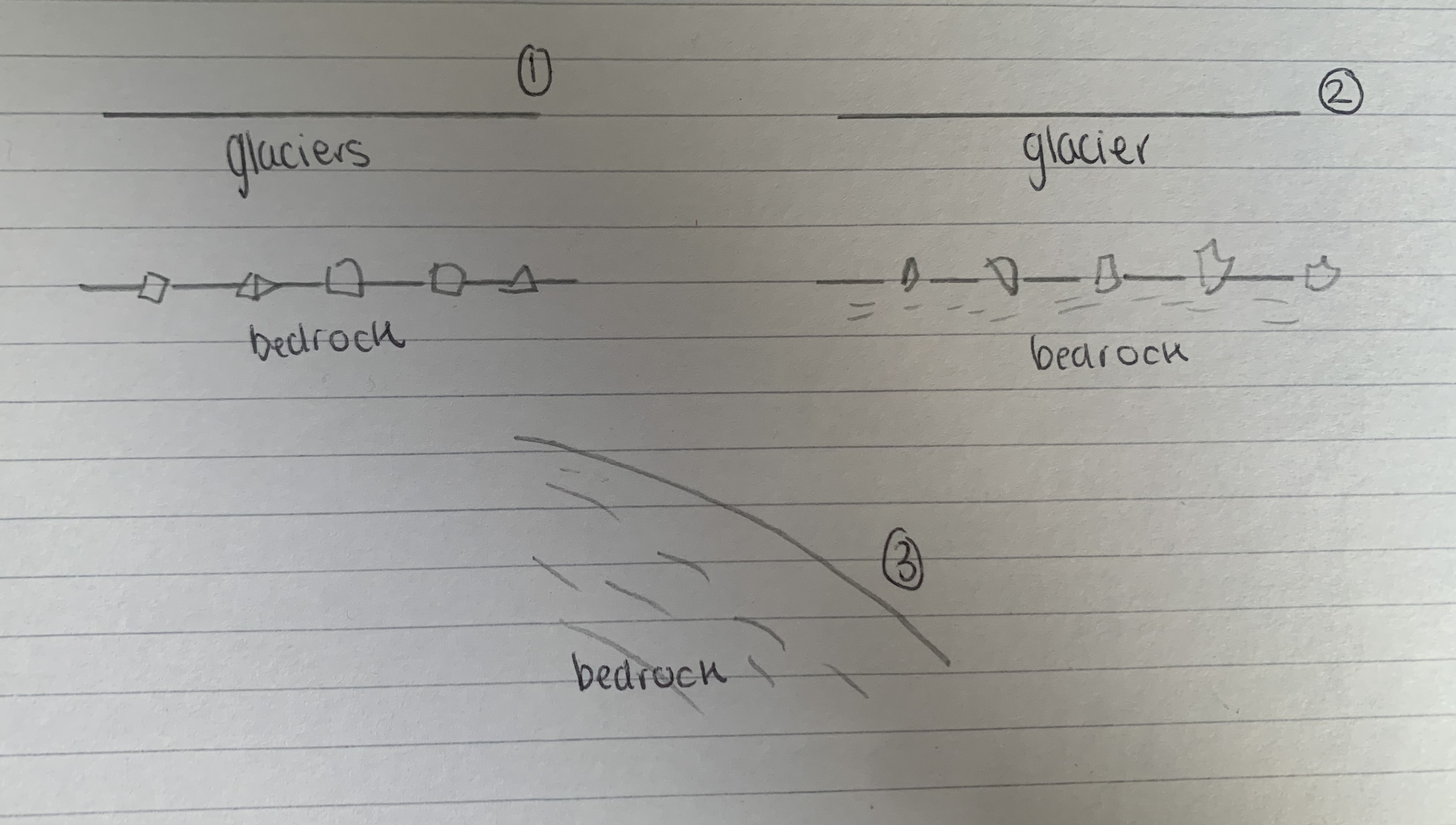
Abrasion - erosion
Angular rock debris are embedded in the base and sides of the glacier
As the glacier moves, the rock in the base of the ice scrape against the bedrock - sand paper effect
After ice has melted, smooth rock is left behind, often with striations (scratches in the rock surface)
Ice thickness - factors effecting erosion
Increased thickness of ice = increased pressure placed on debris = increased abrasion
Too much ice will cause too much pressure = increased friction, reduction in movement
Thickness tends to be 100-200 M
Debris size and shape - factors effecting erosion
Debris exerts large pressure downwards compared to there weight
Larger the debris the more useful
Angular debris is also useful as the pressure is on one bit of he bedrock
Presence of basal debris - factors effecting erosion
Ice can’t erode itself
Rate increases when more debris is present, movement of the glacier may slow due to too much friction
Hardness of particles and bedrock - factors effecting erosion
Most effective when hard debris is moved across a soft bedrock
If the bedrock is resistant, a little abrasion will occur
Removal of fine debris - factors effecting erosion
To maintain high rates of abrasion, rock flour needs to be removed so that larger debris can abrade the bedrock
Mainly done by meltwater
Movement of debris to the base - factors effecting erosion
Abrasion doesn’t just wear down bedrock but also erodes the debris
Debris needs to be replenished if abrasion is to remain effective
Sliding of basal ice -factors effecting erosion
Abrasion requires sliding to ensure rocks move across the surface
High rates of sliding more potential for erosion as more debris is able to move across the bedrock
Basal water pressure - factors effecting erosion
A layer of meltwater is vital for sliding and abrasion
If the water is under pressure, the glacier is buoyed up, low pressure and erosion
Emblemton and king 1968 - factors effecting erosion examples
Mean annual erosion for active valley glaciers is bettween 1000-5000 m³
Glacier d’argentere - factors effecting erosion example
Ice 100m thick flowing 250 m/year, eroded a marble plate at up to 36 mm/year
Bolton 1974 - factors effecting erosion example
Measured rock plates beneath the breiömerkurjökull glacier, Iceland
Found ice 40m thick, basalt eroded 7mm/year, marble 3mm/year
Ice had velocity 9.6m/year, increased to 15.4m/year as erosion of marble increased to 3.75 mm/year though ice was 8m thicker
Suggests velocity is more important than thickness
Supraglacial
Debris carried on top of/ surface of a glacier
Comes from weathering and rockfall
Englacial
Debris within the ice
Possibly supraglacial covered by snowfall, fallen into crevasses or sunk into the ice due to pressure melting
Subglacial
Debris emmbedded into the base of the glacier from plucking and abrasion
Could have continued down through the ice as former englacial debris
Deposition information
Glaciers deposit when there capacity to transport the material is reduced - due to ablation during times of retreate
all deposits are known as drift
Lodgement till
Deposed by advancing ice, due to downward pressure by thick ice
Subglacial debris may be pressed into valley floor and left behind
Enhanced pressure melting
Drumlins are the main land form
Ablation till
Deposited by melting ice, form stagnet / retreating glaciers (durning a warm period / the end of glaciation events)
Most glacial deposition land forms are due to this
Angular / sub-angular in shape (deposition)
Embedded in ice and no further erosion processes (particularly meltwater which could make the rock smooth)
Unsorted depositon
All deposits are deposed together (dosen’t matter the size and weight )
When water deposits it losses energy and deposits in a size based way
Unstratified deposition
Glacial till dropped in mounds and ridges rather than layers - typical of water-borne deposits
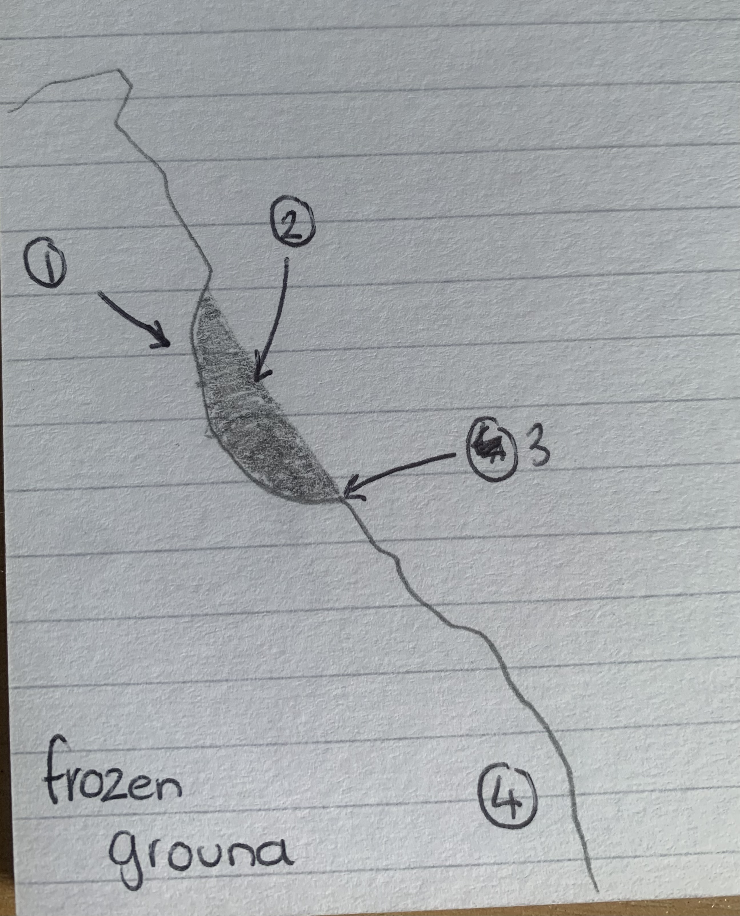
Formation of Corrie - early stage of glacier
Freeze-thaw action
Fresh snow
Debris removed by meltwater stream
Surface thaws in the summer
Starts with nivation of a small hollow, overtime they enlarged and contain more snow, compresses into glacial ice
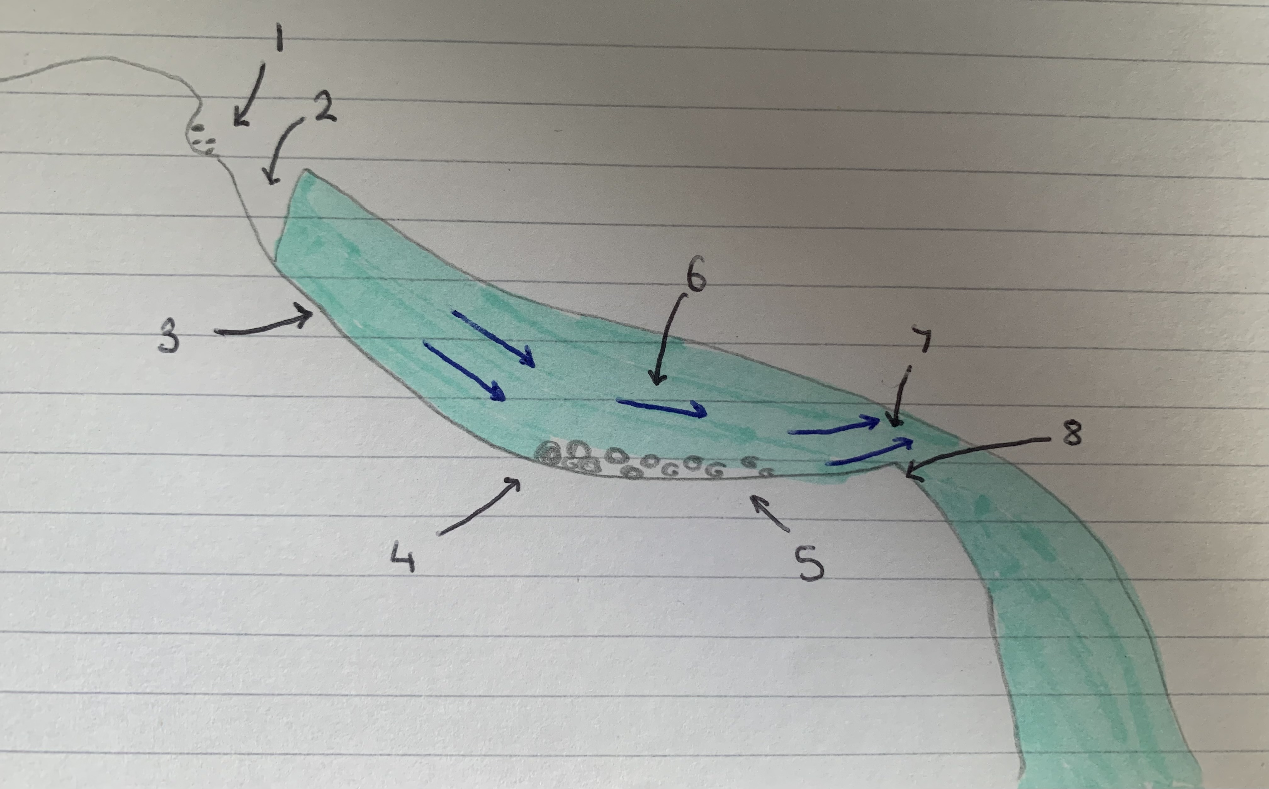
Formation of corrie - during glaciation
Frost-shattering above glacier
Bergschrund crevasse
Plucking
Frost-shattering
Abrasion
Flow path of ice
Rotational flow
Corrie lip
Formation of glacier - during glaciation
Ice acquires a rotational movement under its weight
Causes plucking of the back wall, increase steepness
Debris allows the hollow to deepen
Thinner ice can’t erode so a higher lip is left
Lip may contain moraine deposited by the ice as it moves out of the corrie
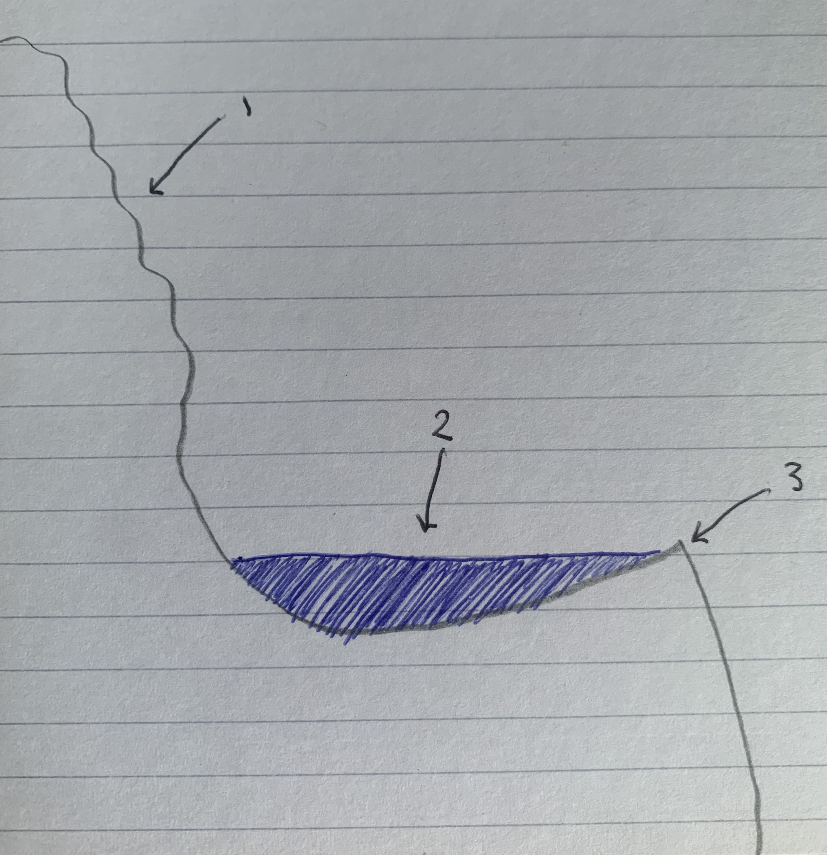
Formation of corrie - post-glacial
Headwall
Tarn (dammed by rock lip)
Rock lip (threshold)
Corrie may become filled with water forming a small circular lake / tarn
Arêtes
Narrow steep-sided ridge between 2 corries described as knife edged (very thin)
Striding edge, each side are 200-300 m high (almost vertical) - can walk one person at a time
Pyramidal peak
Where 3+ corries develop around a hill or mountain top and there back wall retreat - remaining mass will form a pyramidal peak
Example is weisshorn Switzerland
Truncated spur
Erosion of the valley to create the parabolic shape, the base flattens/ cuts into the v shaped valley
Hanging valley
Deferential erosion between a smaller glacier joining a larger glacier, where the smaller one connects to it higher up as can’t erode as much so appears to be hanging
Rock step
Are less eroded and more resistant because the glacier was ‘younger’ and had less mass so the glacier couldn’t erode the resistant rock (found just after corries)
Roche moutonnee
More resistant rock (an igneous intrusion), that have been smooth/rounded up-valley and a steep, jagged down-valley