Unit 6: Cities and Urban Land Use
1/71
Earn XP
Name | Mastery | Learn | Test | Matching | Spaced | Call with Kai |
|---|
No analytics yet
Send a link to your students to track their progress
72 Terms
a model highlights how transportation advancements can create new economic opportunities and alter urban landscapes, impacting population distribution and land use patterns.
Bochert’s Transportation Model
the process by which an increasing percentage of a population comes to live in urban areas, leading to the growth and expansion of cities.
Urbanization
the growth of areas outside of an urban core, leading to an expansion of the metropolitan area and a shift in population and economic activity. Key drivers include seeking more affordable housing, larger homes, and a perceived better quality of life.
Suburbanization
is a rapidly growing, sprawling city of 100,000 or more on the edge of a major metropolitan area.
Boomburb
significant urban centers that emerge on the outskirts of traditional cities, characterized by a concentration of retail, office space, jobs, and entertainment
Edge cities
a residential area situated outside a city and its suburbs, characterized by low population density, wealthier residents, and rural lifestyles while still being near an urban area
Exurb
urban areas with a population of over 10 million people. They are characterized by their size, complexity, and diversity, and are often centers of economic, political, and cultural activity.
Mega city
urban centers with a population over 20 million people that are major players in the global economy and are connected to a network of other global cities through economic, cultural, and political linkages. These cities are often centers of innovation and creativity, and they often have a significant influence on global trends and issues.
Meta city
the uncontrolled expansion of cities into surrounding rural land, leading to low-density development that is heavily car-dependent
Urban sprawl
a major urban center that functions as a hub for economic, political, and cultural activity on a global scale, driving globalization
World/global city
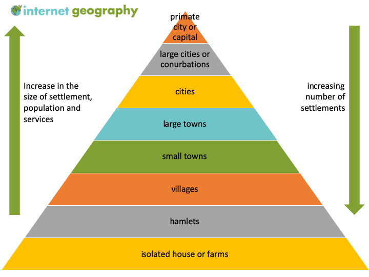
the organization of settlements in a ranked order based on their size, functions, and services provided. Larger cities tend to offer a greater variety of services and play a more significant role in economic and social networks, compared to smaller towns.
Urban hierarchy
specialized services that require advanced skills, education, and training, typically found in larger cities. These services have a larger threshold and range. These can include specialized hospitals, large shopping centers, stadiums, large regional airports, and cultural centers.
High order service
everyday, basic goods and services that are needed frequently, such as groceries, post offices, and local bakeries. These services are provided in smaller settlements like villages or local neighborhoods and are characterized by a low threshold population and a low range
Low order services
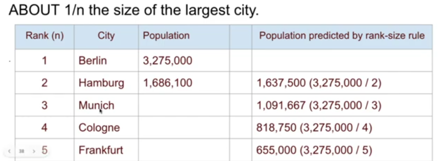
a principle that describes the relationship between the size of a city and its rank in a hierarchy of cities within a particular area: the second-largest city is half the size of the largest, the third-largest is one-third, and so on
Rank size rule
a leading city in a country that is significantly larger and more influential than any other city within that state.
Primate city
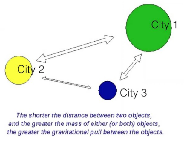
a spatial interaction theory based on Newton's law, predicting that interactions (like trade, migration, or communication) between two places are directly related to their population sizes and inversely related to the square of the distance between them, meaning larger, closer places attract more interaction.
Gravity model
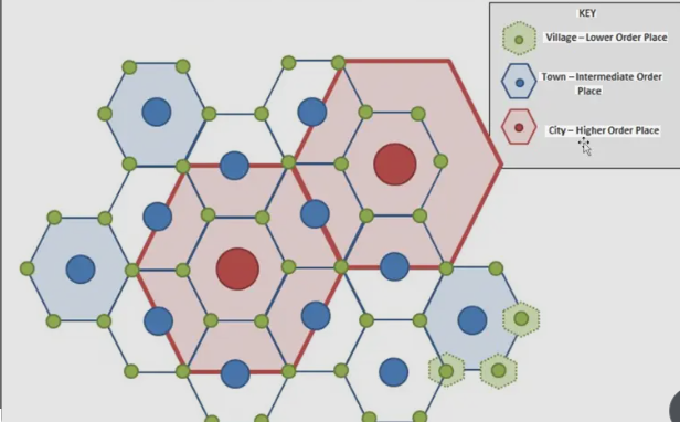
a theory that states a settlement (city, town, village) that serves as a market hub, providing goods and services (like groceries, doctors, jewelry) for its surrounding region, called the hinterland
Central Place Theory
the minimum number of people needed to support a particular service or business
Threshold
the maximum distance people are willing to travel to obtain a good or service
Range
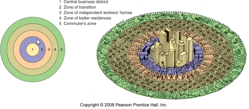
an urban model used to describe how cities grow in a series of concentric rings radiating from a central business district (CBD).
Concentric Zone Model/Burgess Model
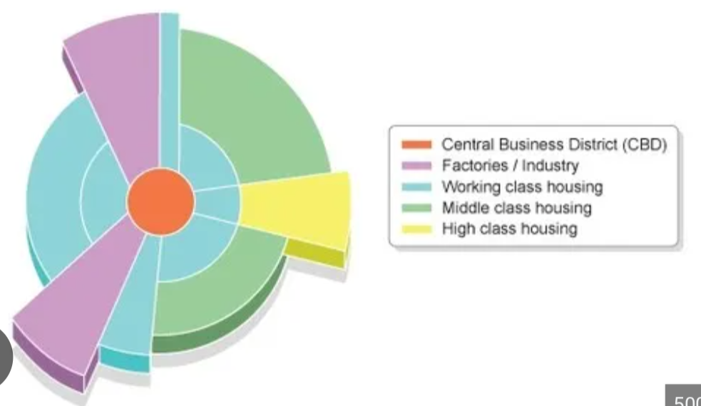
urban model that explains that cities grow in wedge-shaped sectors or corridors radiating from the Central Business District (CBD), influenced heavily by transportation routes (like railroads, roads, rivers). This model shows specific land uses (industrial, low-income, middle-income, high-income housing) developing along these transportation lines, creating distinct sectors instead of just concentric rings, with wealthy areas moving further out along the "spine" and industry near transport hubs.
Sector Model/Hoyt Model
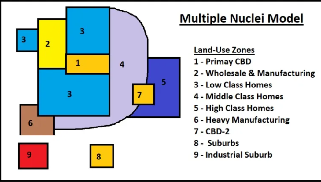
urban model that explains how modern cities grow around several specialized centers (nuclei) instead of just one Central Business District (CBD), reflecting urban sprawl, automobile use, and diverse economic functions like shopping malls, universities, airports, and industrial parks, which form independent nodes attracting different activities and populations
Multiple-Nuclei Model/Harris and Ulman Model
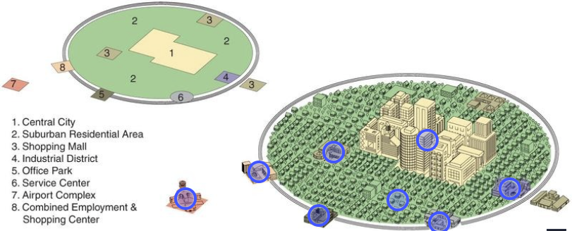
urban model that describes modern cities as decentralized, polycentric urban areas with a central city surrounded by interconnected suburban nodes and edge cities, linked by transportation belts (like interstates/beltways), reflecting sprawl and dispersed economic activity, unlike older models with a single CBD. It emphasizes growth around transportation hubs, forming multiple centers for jobs and shopping, exemplified by cities like Los Angeles.
Galactic City Model (Peripheral model is the same thing)
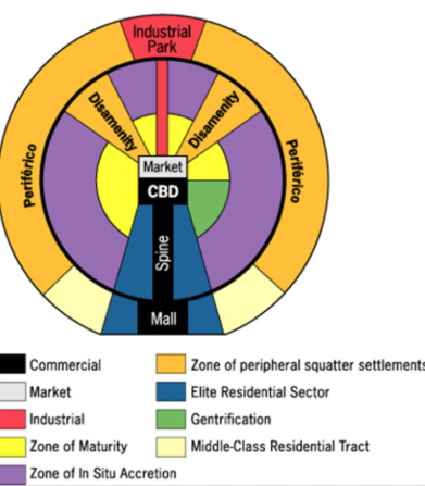
urban model that shows cities with a CBD (Central Business District), a wealthy elite sector/spine extending outwards along transport routes, middle-class housing in between, and poorer peripheral squatter settlements (favelas), reflecting colonization, economic disparity, and globalization where rich live centrally/near spines and poor are pushed to the edges, often near industrial zones
Griffin Ford Model/Model of Latin American Cities
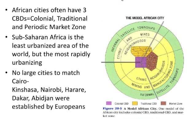
an urban city model that shows unique urban structures with multiple CBDs (colonial, traditional, transitional), concentric rings for different classes, and informal settlements on the periphery, reflecting colonial history, rapid growth, and diverse economic conditions, unlike purely Western models. It highlights stark contrasts between wealthy, planned areas and poorer zones with inadequate services, a key aspect of urbanization in Sub-Saharan Africa.
Model of African Cities
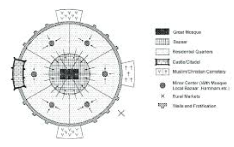
an urban model that describes historic urban patterns centered around a mosque, often walled ( Medina ), with religious/market functions ( souks ), traditional housing, and later additions like palaces and European-style zones, reflecting religious faith and historical layers, distinct from Western models by its Islamic core and distinct social/physical zoning
Model of Middle Eastern & Islamic Cities (MENA)
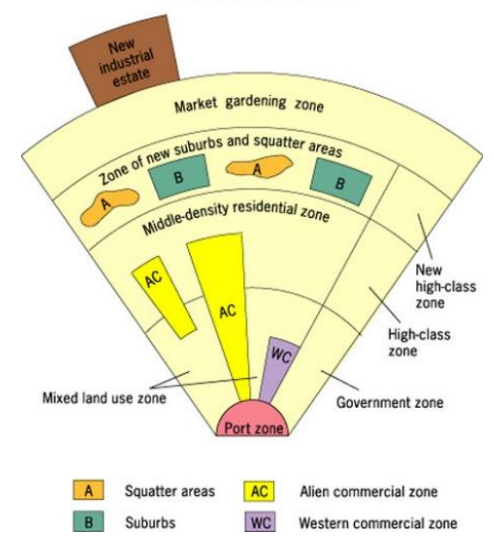
describes the internal structure of many cities in Southeast Asia, where a strong Central Business District (CBD) is absent and replaced by a colonial port zone as the primary focus. This model features multiple zones, including a commercial district, various ethnic neighborhoods, and a separate market gardening zone, all developing around the port and reflecting the region's colonial history and trade-oriented development.
McGee Model of SE Asian Cities
the development of new construction on vacant or underutilized land within existing urban areas, as opposed to expanding outward into suburbs
Urban infill
the fundamental facilities and systems that support the functioning of a society, including transportation, communication, water, schools, etc
Infrastructure
a legally incorporated city, town, or village that functions as a self-governing unit with its own local government
Municipal
an urban planning approach that focuses on sustainable development, promoting efficient land use, and creating livable communities.
Smart Growth Policies
a designated area of open, undeveloped land surrounding an urban area, intended to limit urban sprawl, preserve natural habitats, and promote sustainable development
Greenbelts
an urban area that intentionally limits its development and population growth to combat the negative effects of urban sprawl. These cities use smart growth initiatives, such as establishing greenbelts or urban growth boundaries to prevent outward expansion and encourage denser development within the existing city footprint
Slow-growth Cities
an urban design movement focused on creating walkable, mixed-use neighborhoods to counteract urban sprawl. It emphasizes human-scale design, pedestrian-friendly streets, and public transportation to create vibrant and sustainable communities where people can live, work, and socialize in close proximity.
New Urbanism

an urban planning concept combining residential, commercial (shops, offices, restaurants), and sometimes recreational/cultural spaces (parks, theaters) in one area or building
Mixed Used Neighborhoods
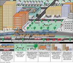
an urban planning strategy that creates compact, walkable, mixed-use neighborhoods centered around high-quality public transportation hubs
Transit Oriented Development
the smallest geographic unit for U.S. Census data, acting as the "building block" for all other geographies like tracts and counties (Can be a small city block or hundreds of square miles in remote areas.)
Census block
the discriminatory practice where financial institutions deny or limit services (loans, insurance, mortgages) to residents in specific neighborhoods, often predominantly Black or minority areas, based on racial/ethnic composition, not creditworthiness
Redlining
a real estate practice where agents exploit racial fears to encourage white homeowners to sell their properties at low prices by falsely suggesting that minority groups are moving into the neighborhood. These agents then resell the properties to minority buyers at inflated prices, profiting from the racial segregation and panic selling.
Blockbusting
areas within a city that lack basic services and infrastructure and are characterized by high levels of poverty, crime, and unemployment
Disamenity zones/zones of abandonment
a complex urban process where deteriorating neighborhoods undergo transformation through an influx of more affluent residents, leading to increased property values and the displacement of long-term, lower-income residents
Gentrification
the environmental impact of an individual, community, or organization by calculating the amount of land and water area required to produce the resources consumed and absorb the waste generated
Ecological footprint
Which of the following best explains why countries such as Brazil, Burma (Myanmar), Kazakhstan, and Nigeria would construct a new capital city in a different location from the old capital city?
To build modern, planned cities and administrative centers
Which of the following similarities best explains why cities such as Venice, Amsterdam, Hamburg, London, and Marseilles were early front-runners in urban development in Western Europe?
These port cities were centers of trade, serving as links in terms of capital and labor mobility.
Which site factor best explains the linear pattern of urbanized areas extending between Washington, D.C., Philadelphia, New York, and Boston?
The development of cities in the region was influenced by the abundance of deep-water harbors and waterfalls where the flat coastal plains met higher lands.
As old central business districts and industrial zones in more developed countries lost businesses and employment in the mid- to late twentieth century, suburban development expanded. Which of the following types of cities resulted from rapid suburban growth and the expansion of retail areas, office developments, business centers, and corporate headquarters to provide jobs and services in suburban areas?
Edge cities
La Défense is an edge city constructed in the late twentieth century and characterized by high-rise office buildings. Which of the following best explains why La Défense is located on the outskirts of Paris?
The land at the center of Paris is filled with numerous historic buildings that residents do not want torn down.
Which of the following best explains a geographic characteristic shared by megacities in the global periphery?
Megacities demonstrate unplanned growth patterns and often contain squatter settlements.
The presence of media hubs, coalitions focusing on specific environmental challenges, and headquarters for multinational corporations in major cities help explain how such cities
are linked globally in ways that transcend national political boundaries

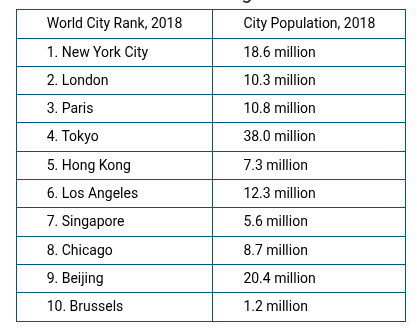
Which of the following best illustrates how the world cities in the table are connected globally in ways that transcend national borders?
Chinatown and the United Nations are located in New York City

Which of the following statements best explains how the world cities listed in the table function within the world’s urban hierarchy?
The top ten world cities have a significant impact on the international economy and are important drivers of globalization.
Which of the following best explains why New York City has more specialized stores than do smaller urban places in the United States?
Central place theory
Which of the following is a general theory in geography that can be used to quantify and predict the interaction between two cities based on population sizes, distance between the places, the number of migrants moving from one place to the other, or the flow of trade goods between the two locations?
Gravity model
According to the rank-size rule, which of the following is typically true of higher-order services, such as hospitals with a large number of medical specialties?
They have high ranges and thresholds

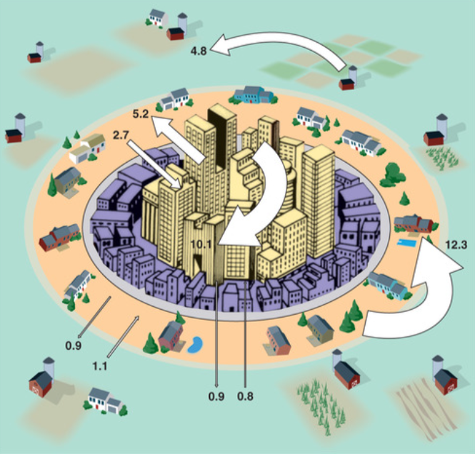
Based on a comparison of the zones in the model shown, which of the following best explains how the model is limited in its representation of present-day urban land-use patterns?
The model does not show the cost-to-distance effects of multiple suburban central business districts and the pattern of residential areas that surround them.
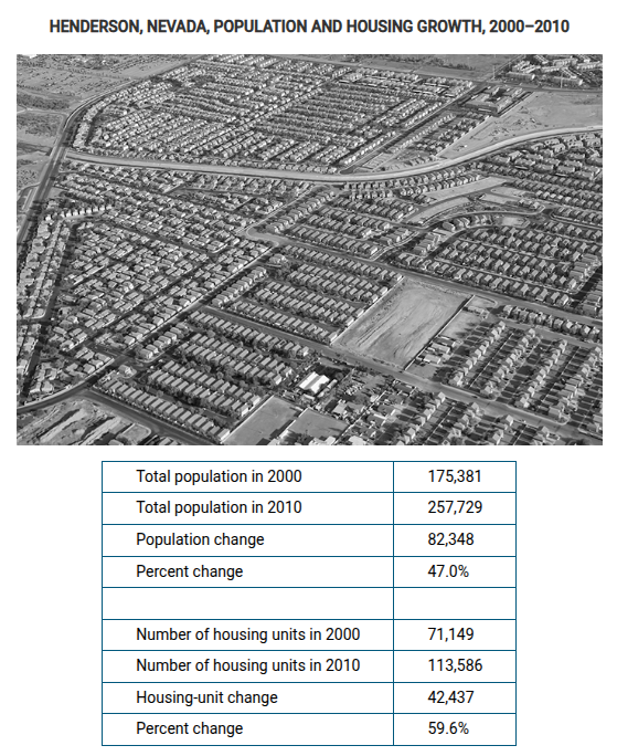
The photograph above shows high-density residential housing built in the early 2000s in Henderson, Nevada, a suburb of Las Vegas, developed to accommodate large increases in population in the area. Which of the following best explains the growth in population and housing shown in the image and the census data?
A cycle of rapid economic development and real estate investment
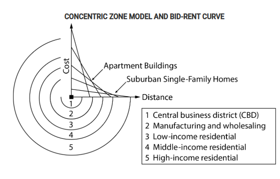
Which of the following statements explains the cost and distance relationship illustrated in the model in relation to the urban area’s residential patterns?
The lower cost of land farther from the CBD makes it affordable to build single-family homes in zones 4 and 5 for middle-income and high-income residents who desire to move into less crowded areas.
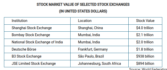
Which of the following best explains the importance of stock exchanges in the cities of Mumbai, India and Shanghai, China?
These cities function as global economic centers in the semiperiphery.
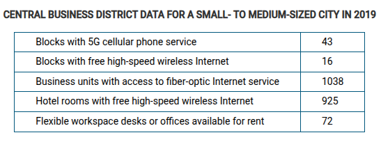
Which of the following best explains what the central business district data indicate?
Government policy makers and business partners have focused infrastructure efforts on creating a downtown work environment that is positive for economic development.
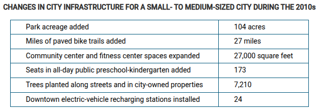
Which of the following best explains the city planning trends shown in the data table?
Social development efforts have been made to improve the quality of life for city residents.
New Urbanism is an example of sustainable urban development. This type of development is intended to
reduce the miles driven on personal vehicles
Which of the following exemplifies a smart-growth approach to urban planning?
Creation of walkable neighborhoods with mixed-use land and access to public transportation
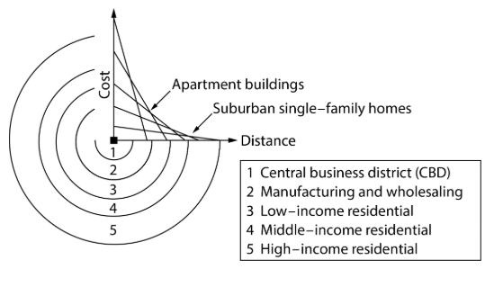
The model above represents zones that are present in many American cities. Which of the following design concepts of urban development is likely to have the most significant impact on the reduction of urban sprawl?
Mixed-use land development in zone 5 of the model

Which of the following best explains what the concentric zone model and bid-rent curve illustrate about patterns of urban areas?
Together they show how land prices rise exponentially closer to the central business district.
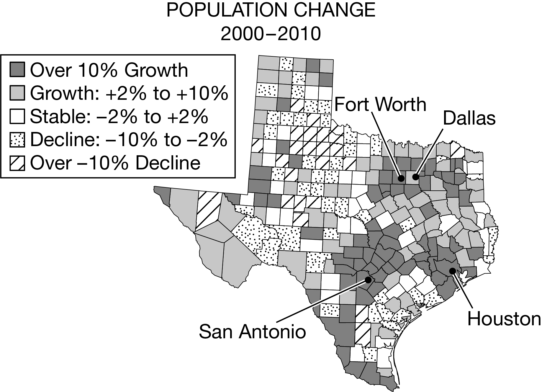
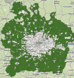
The map above shows percent change in population for counties in Texas from the 2000 to the 2010 census. The three largest metropolitan areas are Dallas-Fort Worth (Tarrant and Dallas Counties), Houston (Harris County), and San Antonio (Bexar County). Which of the following statements best explains urban growth in the period from 2000 to 2010 ?
The greatest percentage growth in population occurred in counties adjacent to the three largest metropolitan areas, indicating continued suburbanization.
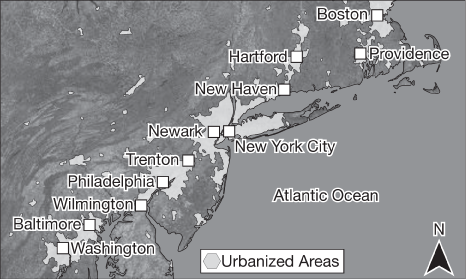
The map shows urbanized areas. Which of the following additional types of quantitative data will be most helpful to a geographer analyzing expansion of the urbanized areas shown on the map?
A census tract map of each city and the surrounding counties showing the difference in population density over a ten-year period
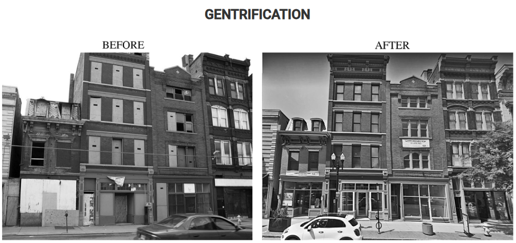
Although gentrification can revitalize cities by rehabilitating residential areas, which of the following problems can be explained by the type of building renovations shown in the before and after images?
Higher rents causing displacement of existing residents
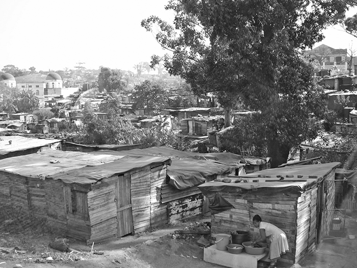
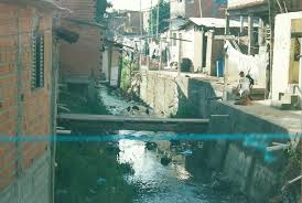
The image shows a squatter settlement at the edge of a city in South Africa. What information regarding causes and effects does the image convey?
The image shows the living conditions of people in the squatter settlement, who are unable to acquire permanent housing within the city.
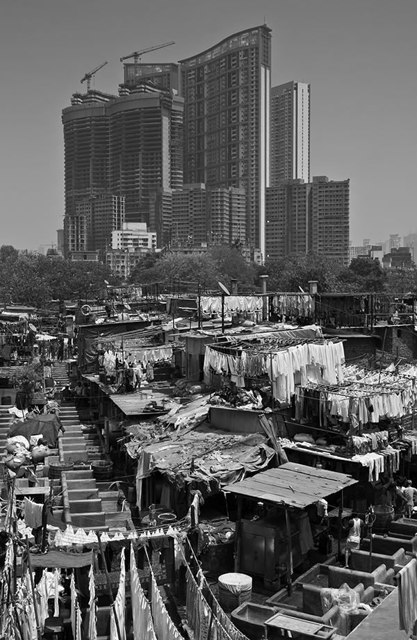
As migrants from rural areas continue to move to cities for jobs, cities face a variety of economic and social challenges. Which of the following economic or social challenges is best illustrated by the photograph shown of Mumbai, India?
There is a significant income gap between residents on the periphery of the city and residents in the city center.