AP Human Geography Models
1/28
There's no tags or description
Looks like no tags are added yet.
Name | Mastery | Learn | Test | Matching | Spaced |
|---|
No study sessions yet.
29 Terms
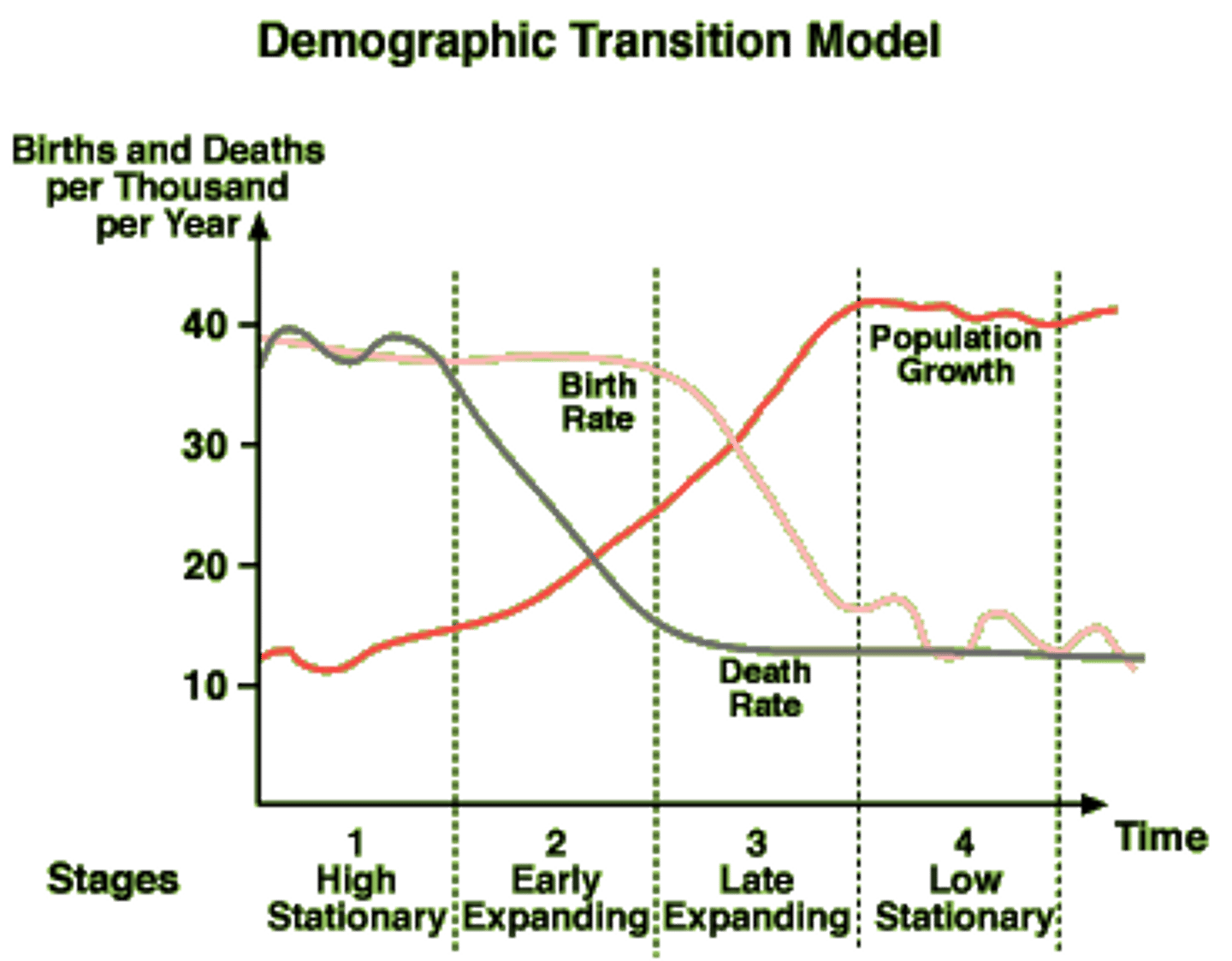
Demographic Transition Model (DTM)
In the four stages of transition from an agricultural subsistence economy to an industrialized country, demographic patterns move from extremely high birth and death rates to low birth and death rates. In the process, population growth rates skyrocket and then fall again. The crude death rate first falls because of the influx of better health technology, and then the birth rate gradually falls to match the new social structure.
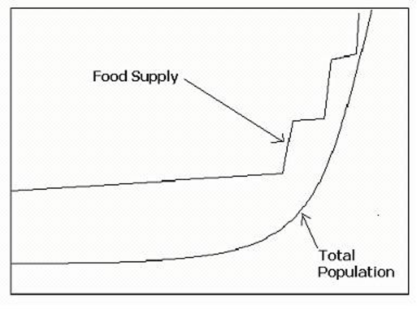
Boserup Hypothesis
Based on the observation that explains how population increase necessitates increased inputs of labor and technology to compensate for reductions in the natural yields of swidden farming.
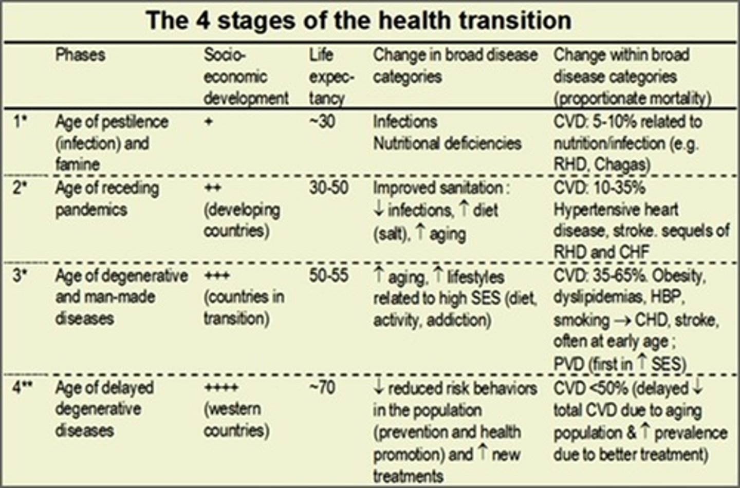
Epidemiologic Transition Model
Disease vulnerability shifts in patterns similar to the DTM. In the early stages, plague and pestilence spread as a result of poor medical technology. As industrialization proceeds, diseases related to urban life spread. In later stages, diseases once thought eradicated reappear as more-developed societies come into easier contact with less-developed regions struggling with the more primitive diseases, such as smallpox and the bubonic plague. Leading causes of death in later stages are related to diseases associated with aging, such as heart disease.
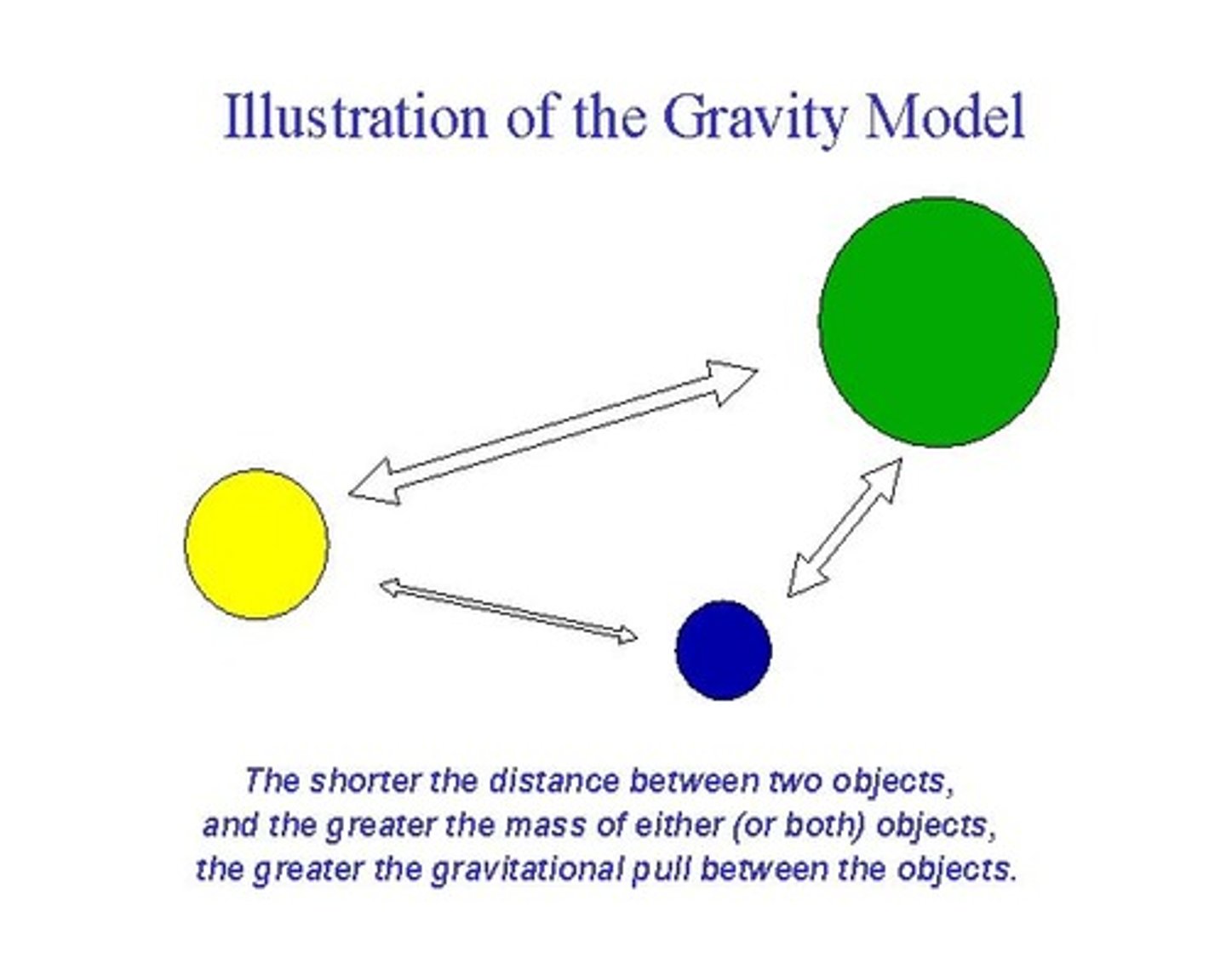
Gravity Model
When applied to migration, larger places attract more migrants than do smaller places. Additionally, destinations that are more distant have a weaker pull effect than do closer opportunities of the same caliber.
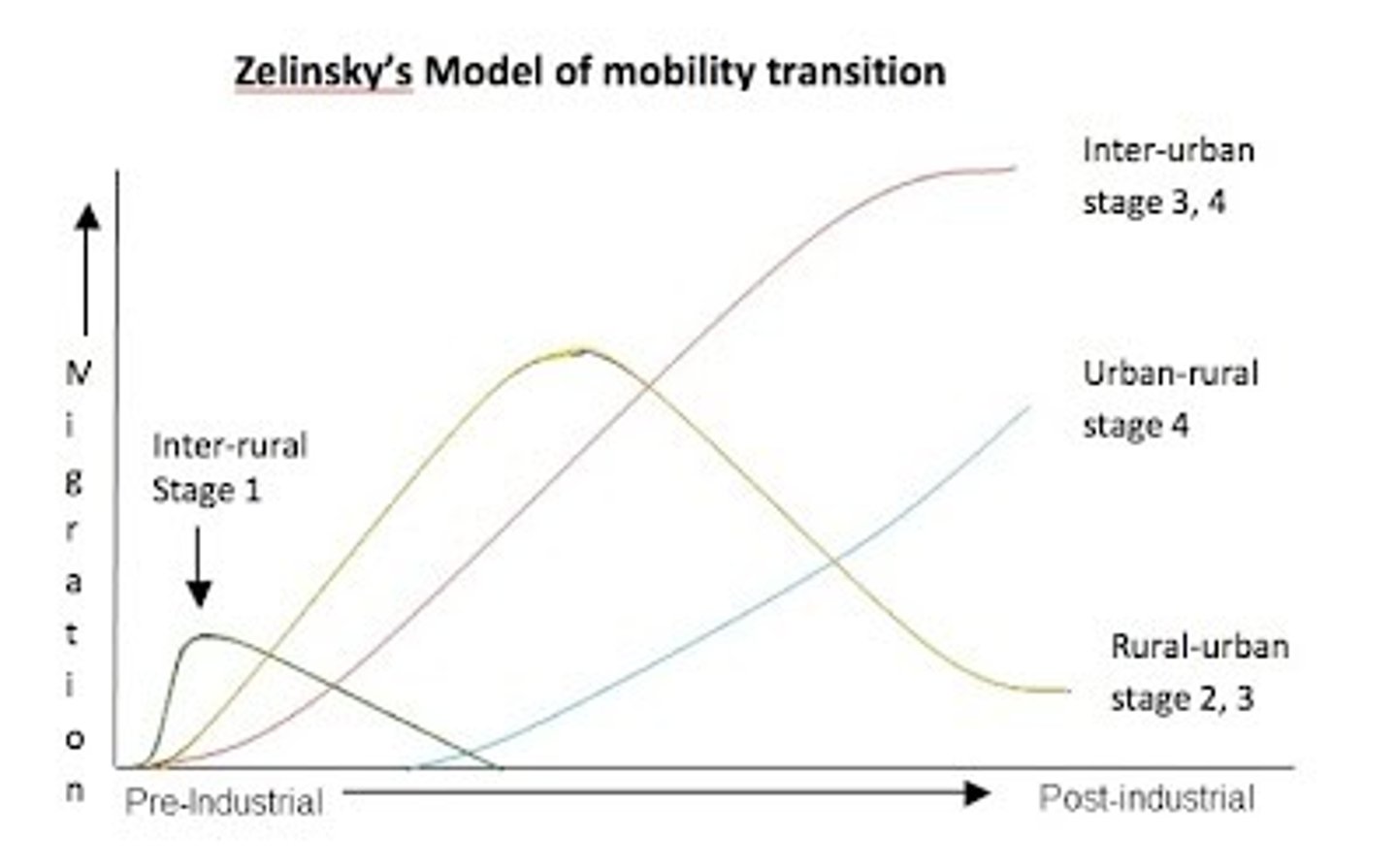
Zelinsky Model of Migration Transition
Migration trends follow demographic transition stages. People become increasingly mobile as industrialization develops. More international migration is seen in stage 2 as migrants search for more space and opportunities in countries in stages 3 and 4. Stage 4 countries show less emigration and more intraregional migration.
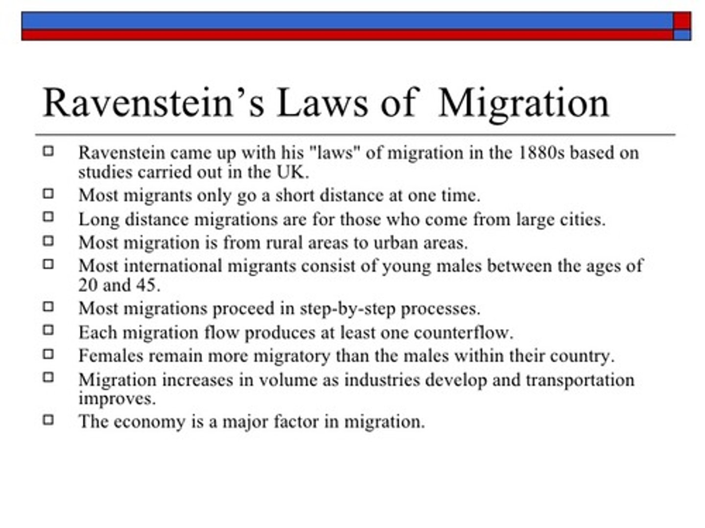
Ravenstein's Laws of Migration
in the 19th century, E.G. Ravenstein used data from England to outline a series of "laws" explaining patterns of migration. His laws state that migration is impacted by push and pull factors. Unfavorable conditions, such as oppression and high taxes, push people out of a place, whereas attractive opportunities, called pull factors, cause them to migrate into regions. Ravenstein's laws state that better economic opportunities are the chief cause for migration; that migration occurs in multiple stages, rather than one move; that the majority of people move short distances and that those who migrate longer distances choose big-city destinations; that urban residents are less migratory than rural residents; that for every migration stream, there is a counterstream; and factors such as gender, age, and socio-economic level influence a person's likelihood to migrate. Keep in mind that his "laws" applied to the timeframe and context of his analysis.
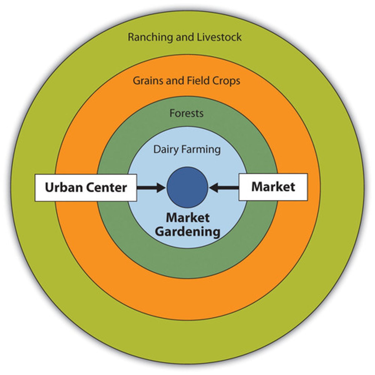
Von Thünen's Model of Agricultural Land Use
Developed by German geographer Johann Heinrich von Thünen, this model explains and predicts agricultural land use patterns in a theoretical state by varying transportation cost. Given the model's assumptions, the pattern that emerges predicts more-intensive rural land uses closer to the marketplace, and more-extensive rural land uses farther from the city's marketplace. These rural land use zones are divided in the model into concentric rings.
Weber's Least Cost Theory
This is Alfred Weber's theory of industrial location, explaining and predicting where industries will locate based on cost analysis of transportation, labor, and agglomeration factors. Weber assumes an industry will choose its location based on the desire to minimize production costs and thus maximize profits. Drawbacks to the model include its assumption of an immobile and equal labor force.

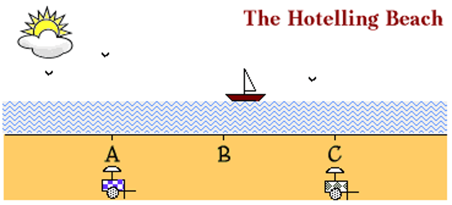
Hotelling's Model
Hotelling's theory asserts that an industry's locational choices are heavily influenced by the location of their chief competitors and related industries. In other words, industries do not make isolated decisions on locations without considering where other, related industries exist.
location of an industry cannot be understood without reference to other industries of the same kind.
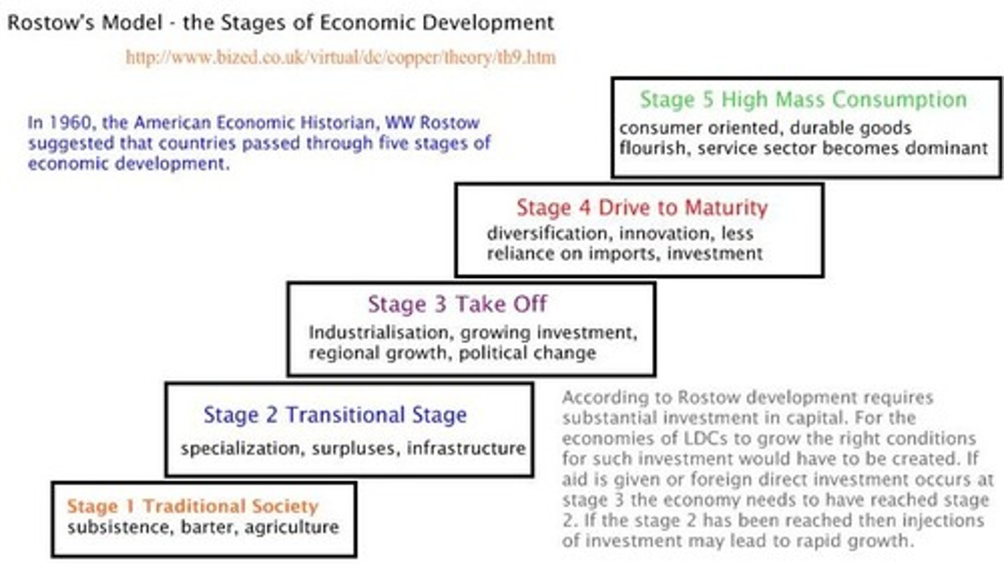
Rostow's Modernization Model (stages of economic development)
Developed in the 1950s, the model exemplifies the liberal development ideology, as opposed to structuralist theory. Under this model, all countries develop in a five-stage process. The development cycle is initiated by investment in a takeoff industry that allows the country to grow a comparative advantage, whch sparks greater economic gain that eventually diffuses throughout the country's economy. Drawbacks to this model include its not identifying cultural and historic differences in development trajectories because it is based on North American and western European development histories.
Borchert's Model of Urban Evolution
Borchert created this model in the 1960s to predict and explain the growth of cities in four phases of transportation history: stage 1, the "sail wagon" era of 1790-1830; stage 2, the "iron horse" era of 1830-1870; stage 3, the "steel rail" epoch of 1870-1920; and stage 4, the current era of car and air travel that began after 1920.
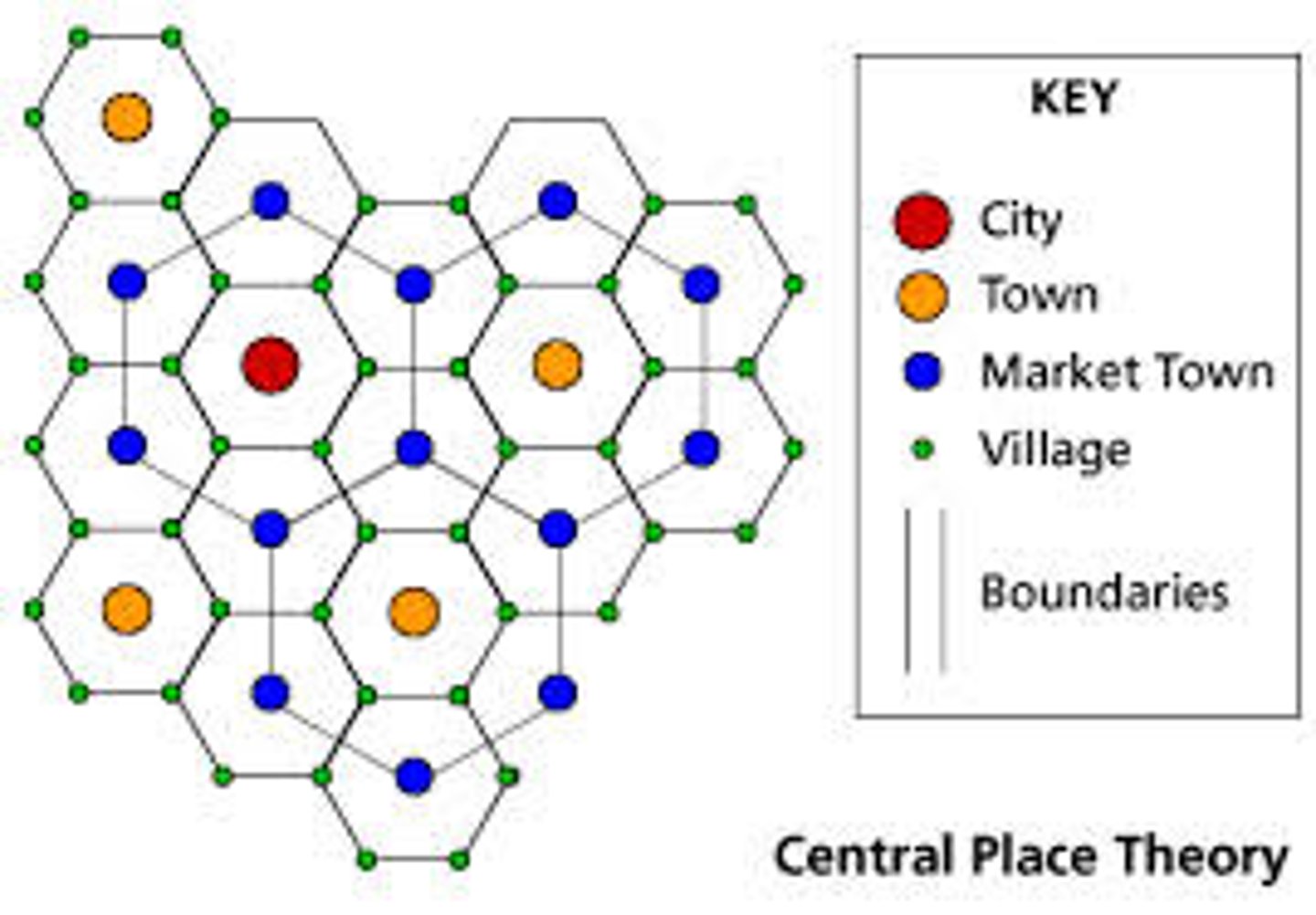
Christaller's Central Place Theory
Developed in the 1930s by Walter Christaller, this model explains and predicts patterns of urban places across the map. In his model, Christaller analyzed the hexagonal, hierarchical pattern of cities, villages, towns, and hamlets arranged according to their varying degrees of centrality, determined by the central place functions existing in urban places and the hinterlands they serve.
Assumptions:
- Flat plane with uniform geography and nature
- Uniform population
- single mode of transportation
- evolution towards the growth of cities
- all persons have a similar income
- all persons have similar consumption patterns
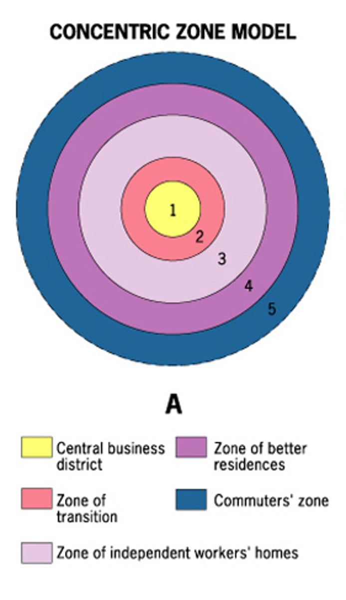
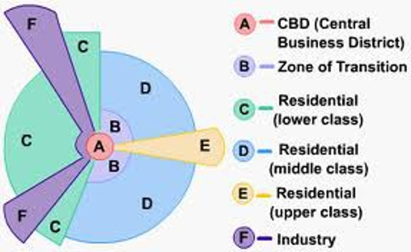
Burgess Concentric Zone Model
This model was devised in the 1920s by Ernest Burgess to predict and explain the growth patterns of North American urban spaces. Its main principle is that cities can be viewed from above as a series of concentric rings; as the city grows and expands, new rings are added and old ones change character. Key elements of the model are the central business district and the peak land value intersection.
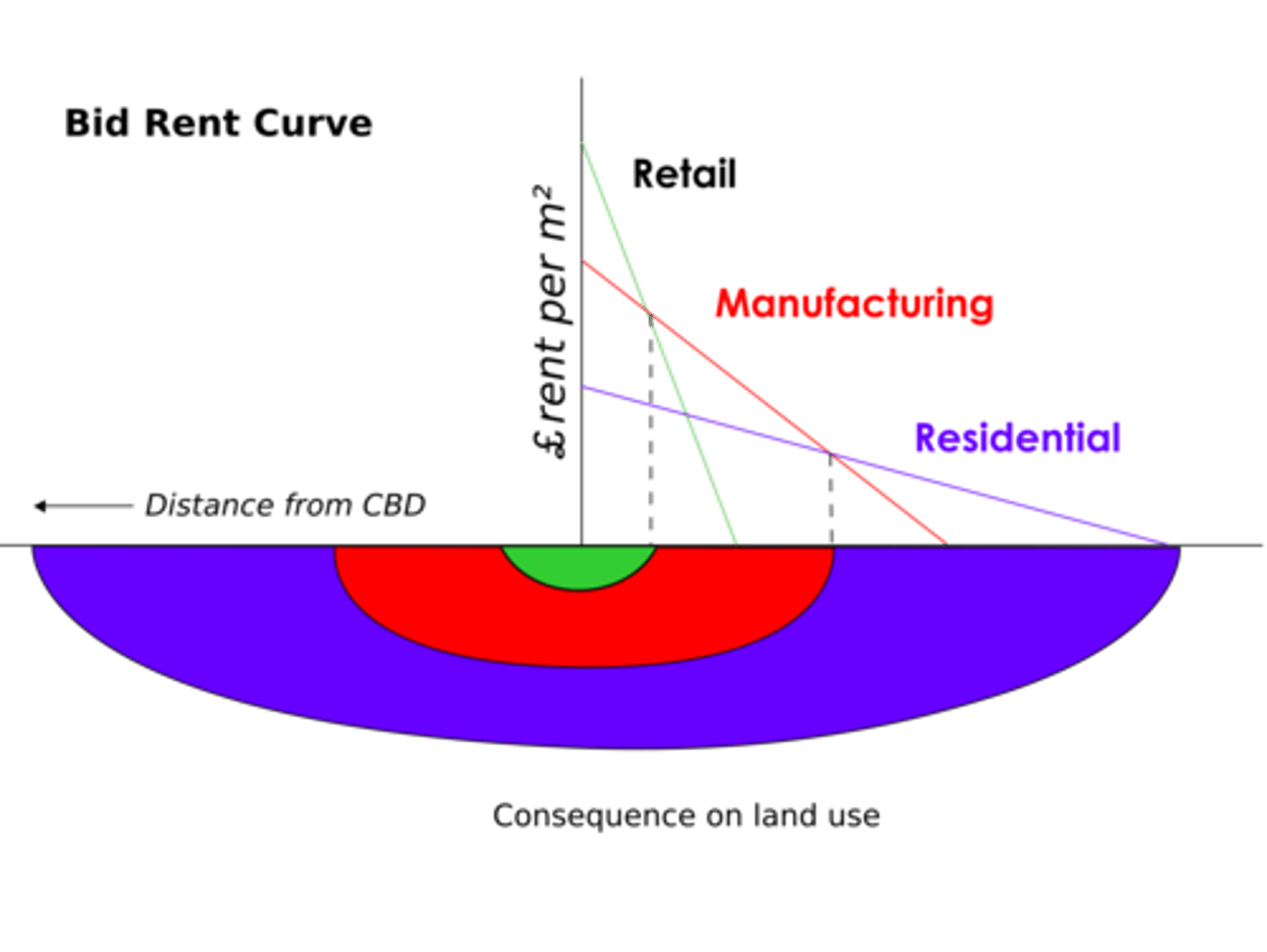
Bid Rent Curve
shows the variations in rent different users are willing to pay for land at different distances from some peak point of accessibility and visibility in the market, often the CBD. Because transportation costs increase as you move away from the market (often the CBD), rents usually decrease as distance increases from the market. Importantly, different types of land use (commercial retail, industrial, agriculture, housing) generate different bid-rent curves. explain the series of concentric rings of land use found in the concentric zone model.
Hoyt's Sector Model
This model, conceived by Homer Hoyt, predicts and explains North American urban growth patterns in the 1930s in a pattern in which similar land uses and socioeconomic groups clustered in linear sectors radiating outward from a central business district, usually along transportation corridors.
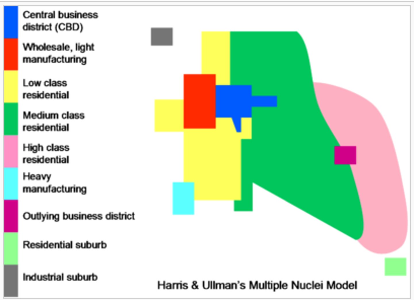
Harris-Ullman Multiple-Nuclei Model
Developed in the 1950s by Chauncy Harris and Edward Ullman, this model explains the changing growth pattern of urban spaces based on the assumption that growth occurred independently around several major foci (or focal nodes), many of which are far away from the central business district and only marginally connected to it.
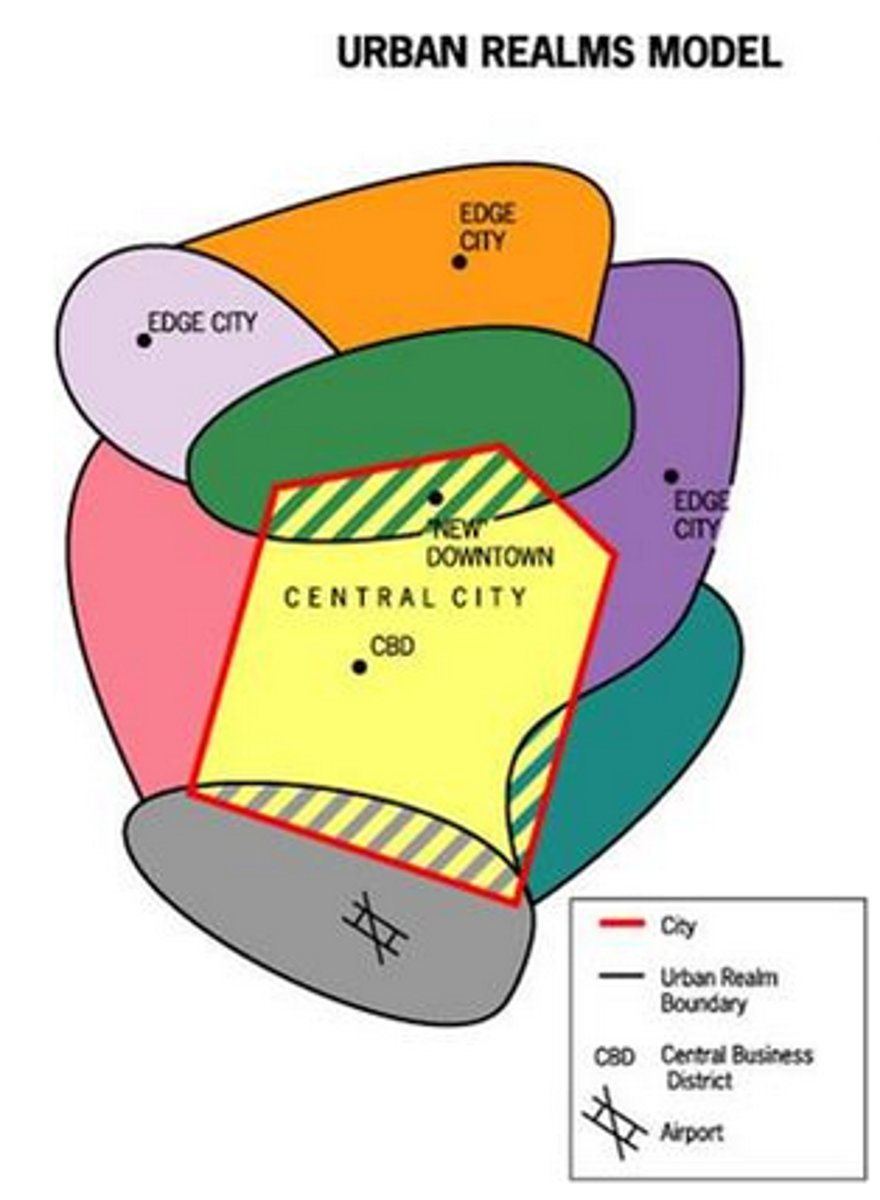
Vance Urban Realms Model
James Vance developed this model in the 1970s to explain and predict changing urban growth patterns as the automobile became increasingly prevalent and large suburban "realms" emerged. The suburban regions were functionally tied to a mixed-use suburban downtown, or mini-CBD, with relative independence from the original CBD.
Renn's New Donut Model
Core Revitalization
New Ring of Poverty

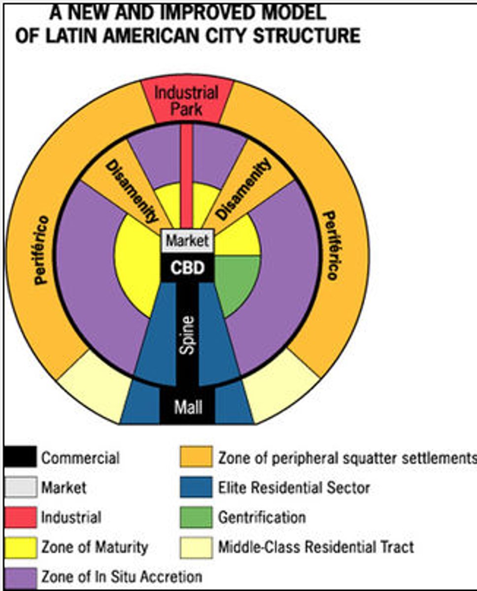
Griffin-Ford Latin American City Model
Larry Ford and Ernest Griffin created a model of the pattern of urban growth in Latin America. Their model contains elements of Latin American culture and imprints of colonization and globalization, such as a prominent plaza and heavy growth around the CBD. However, in the Latin American pattern shown in their model, residential quality decreases with distance from the CBD. The model also presents a zone of maturity, populated with services and a wealthier population; in a zone of squatter settlements, where recent urban migrants set up makeshift housing; and a zone of in situ accretion, which is a transitional zone that shows signs of transition to a zone of maturity.
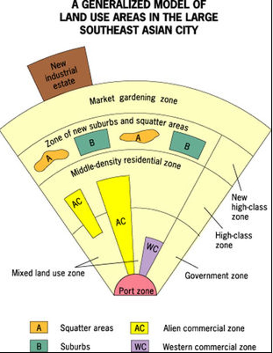
McGee Southeast Asian City Model
Developed by T.G McGee. The focal point of the city is the colonial port zone combined with the large commercial district that surrounds it. McGee found no formal CBD but found separate clusters of elements of the CBD surrounding the port zone: the government zone, the Western commercial zone, the alien commercial zone, and the mixed land-use zone with misc. economic activities.
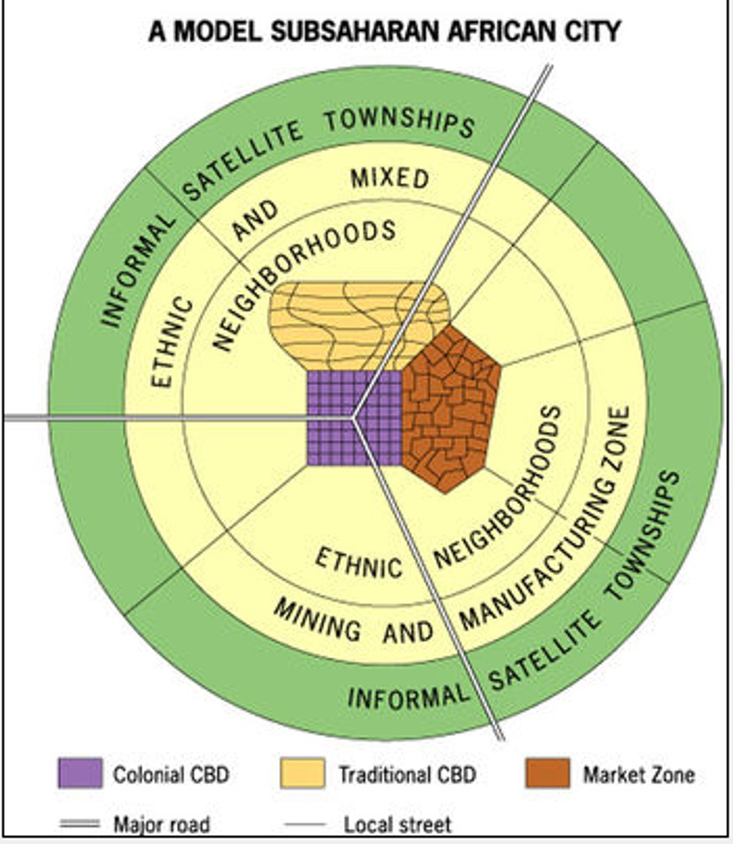
De Blij Sub-Saharan Africa City Model
Developed by Harm De Blij. A model of a city in Sub-Sahara Africa in which there are 3 Central Business Centers: Colonial CBD, Market Zone, and Traditional CBD. The Central Business Districts are encircled by ethnic neighborhoods, ethnic and mixed mining and manufacturing, and finally informal satellite townships
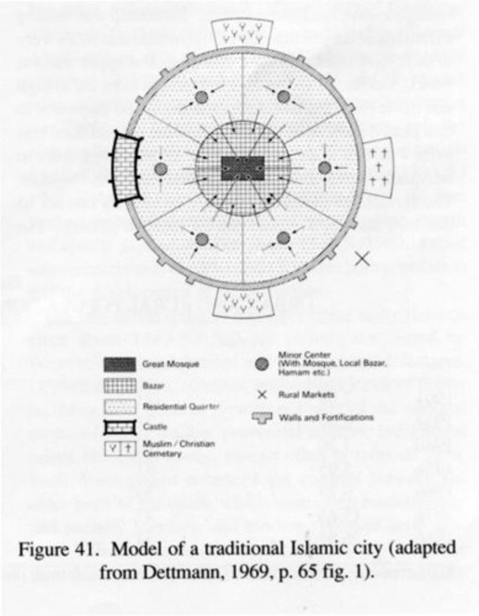
Islamic City Model
Owe their structure to their religious beliefs; contain mosques, open air markets; courtyards, surrounded by walls, limiting foot traffic in residential neighborhoods
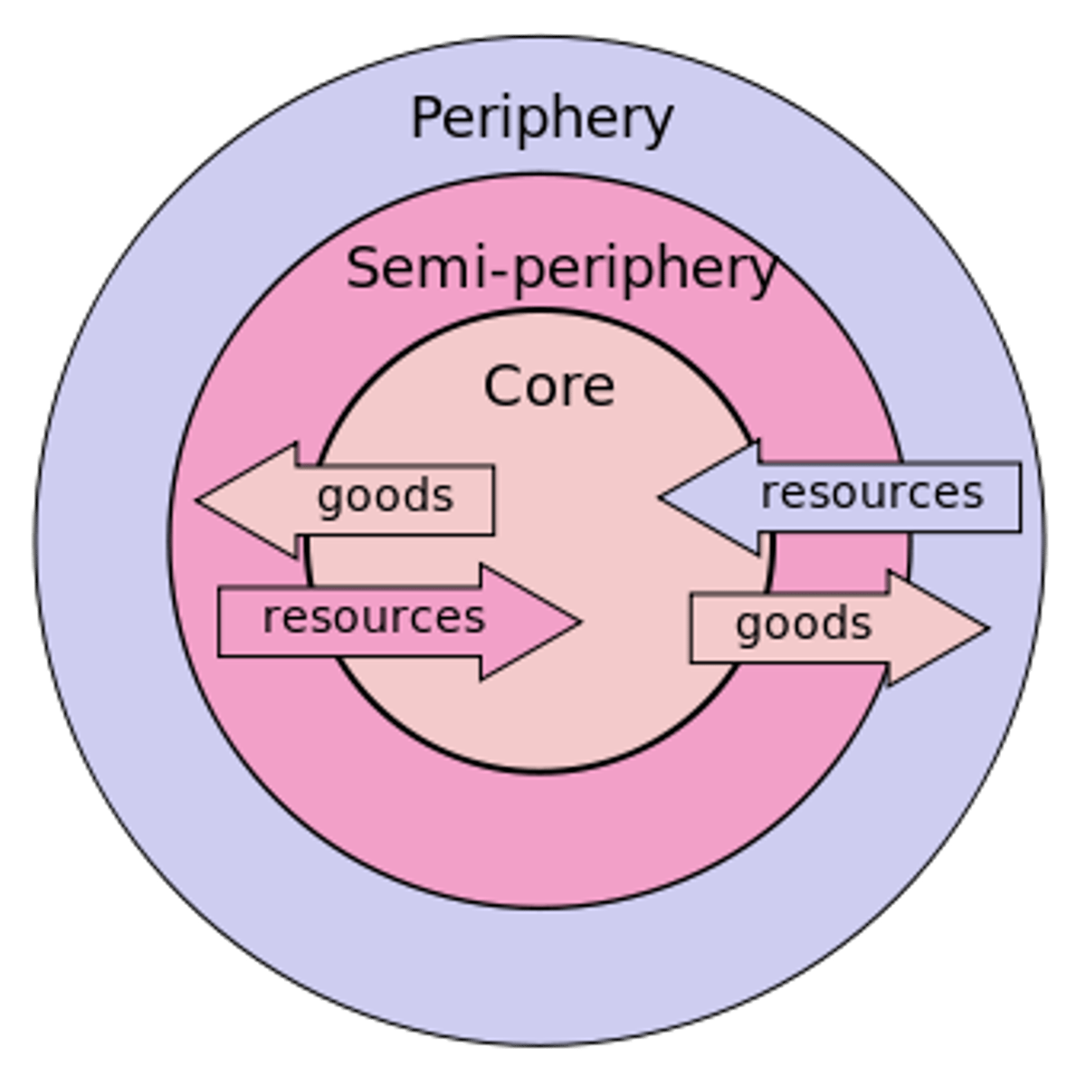
Core-periphery model
Core is the economic, political dominant center (relative center). MDCs above Brandt Line, LDCs around periphery
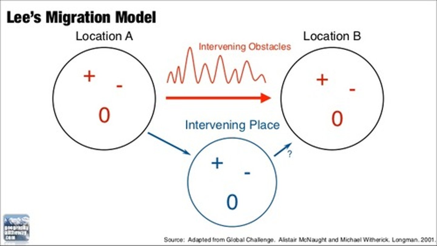
Lee's Migration Model
Model based on Lee's migration theory, that people migrate due to push and/or pull factors, and intervening obstacles are factored
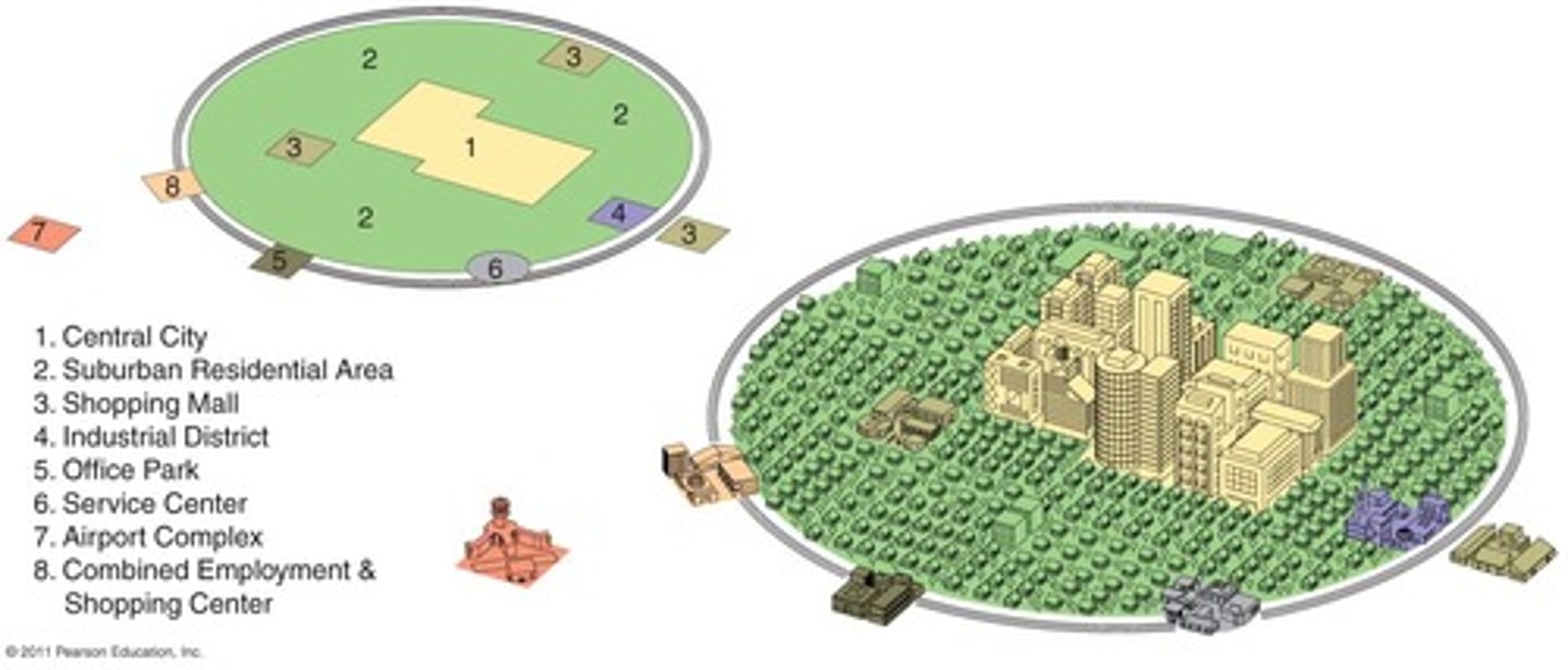
Harris peripheral/galactic city
Developed in the 1960s, interstates introduced. Ring roads play key role in Harris' model; ring roads detrimental to CBD because removes advantage of CBD. CBD loses consumer services, higher income residences, decrease tax base, decrease infrastructure, decrease in education, etc. Ring roads are bad for cities
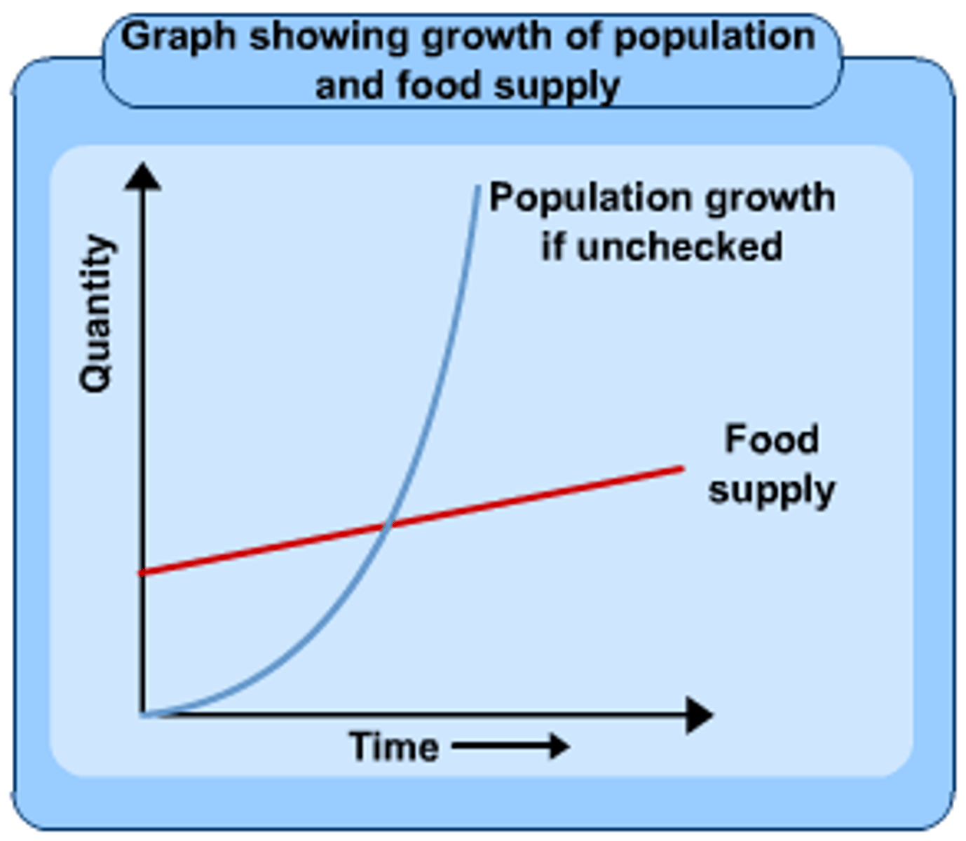
Malthus' Theory of Overpopulation
Malthus argued supply grows linearly (arithmetic), while population was growing geometrically. Also argued for humans to use "moral restraint" to avoid overpopulation
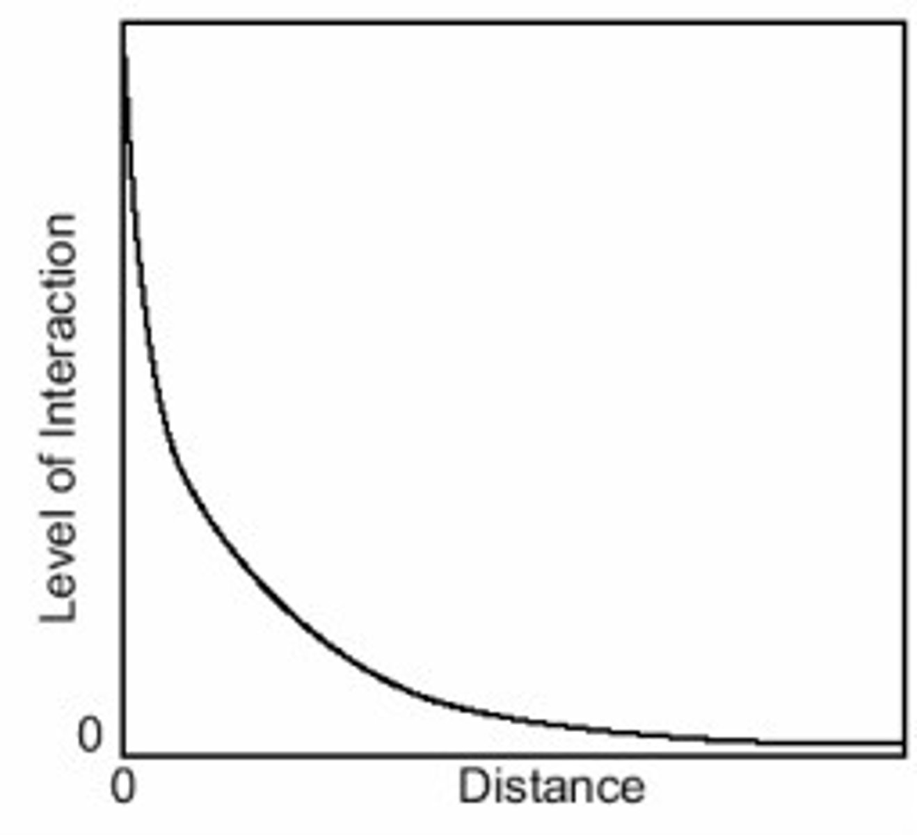
Tobler's First Law of Geography
"All things are similar, but nearby things are more similar than distant things."
Friction of Distance and Distance Decay
Density Gradient Model
The change in density in an urban area from the center to the periphery