Unit 1 Thinking Geographically
1/35
There's no tags or description
Looks like no tags are added yet.
Name | Mastery | Learn | Test | Matching | Spaced | Call with Kai |
|---|
No analytics yet
Send a link to your students to track their progress
36 Terms
absolute location
Exact location of an object
relative location
Description of where a place is in relation to other places or features
space
Area between two or more things
flows
Movement of people, goods or information
pattern
How things are arranged in a particular space
place
Human and physical characteristics that are unique to a location
distance decay
The further away you move from an origin or, the weaker the influence
time-space compression
The reduction in the time it takes to diffuse something to a distant place
determinism
human behavior is controlled by the physical environment
possibilism
humans have more ability to produce a result
scale
the size or geographic area represented on a map
scale of analysis
how zoomed in or out you are when looking at geographic data
region
an area on Earth's surface with certain characteristics that make it distinctive from other areas
formal region
has one or more shared traits
functional region
an area organized by its function around a focal point, or the center of an interest or activity
pereptual/vernacular region
type of region that reflects people's feelings and attitudes about a place
quanititative
information measured by numbers
qualitative
interpretations of data sources such as field observations, media reports, travel narratives, etc.
census
an official count of the number of people in a defined area
Geographic Information System (GIS)
captures, stores, organizes and displays geographic data that can then be used to configure both simple and complex maps.
topography
shape and features of land surfaces
remote sensing
relies on satellites or aircraftbased sensors to collect data.
Global Positioning System (GPS)
An integrated network of at least 31 satellites in the U.S. system that orbit Earth and transmit location data to handheld receivers.
Map scale
mathematical relationship between the size of a map and the part of the real world it shows
reference maps
generalized sources of geographic data and focus on location.
thematic maps
have a theme or specific purpose and focus on the relationship among geographic data
Isoline Map
a map in which lines connect data points of the same value
graduated symbol map
a map in which differently sized symbols are used to indicate quantitative data.
cartogram
a map in which statistical data and geographic location are combined to communicate information at a glance.
dot map
a map in which dots are used to show locations of specific observations or events.
Choropleth Map
a thematic map that uses colors or shading to represent categories of data for predetermined geographic areas or census tracts.
Robinson
Advantages: A globe-like appearance, and not much distortion
Limitations: imprecise measurements, and extreme distortion along the poles
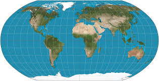
Galls-Peters
Advantages: Shows true direction, and Area is relatively precise
Limitations: distorts shape, and continents appear elongated
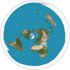
Azimuthal
Advantages: Preserves direction, When used from point of north star no country is in the center
Limitations: distorts shape and area, and shows only one half of earth
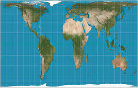
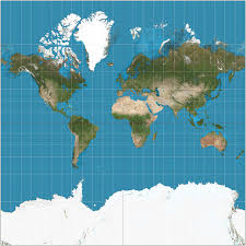
Mercator
Advantages: Shows true direction, and good for navigation
Limitations: Distorts area, and size is distorted more near the poles
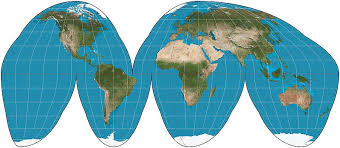
Goodes
What map projection is this?