Sed Strat Week 9
1/42
Earn XP
Description and Tags
coastal environments
Name | Mastery | Learn | Test | Matching | Spaced | Call with Kai |
|---|
No analytics yet
Send a link to your students to track their progress
43 Terms
Shoreline
Actual margin between land and sea. Coastline is behind this
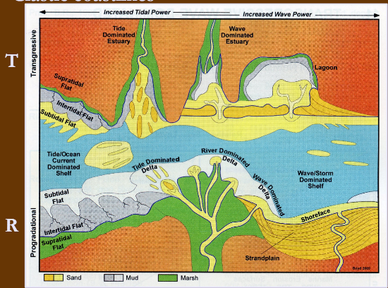
Wave vs tide dominated coastlines
Wave: further offshore, sediment becomes finer due to decreasing wave activity. Long, uninterrupted barrier islands, offshore fining
Tidal: finest sediment is found at the shoreline and coarsens offshore. Barrier islands and deltas are inhibited
Mixed-energy coasts
Most complex; wave and tidal influence. Deltas are much less well-developed than on wave-dominated coasts. Barrier islands are short and stunted, and inlets are wider to allow for large water exchange during tidal cycle
Large tidal deltas
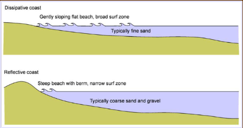
Erosional coastlines (reflective)
relatively steep gradients where much of the wave energy is reflected back to the sea from the shoreline (cliffs)
often seen in transgressive environments

Depositional coastlines (dissipative)
Gentle gradient and much of the wave energy is dissipated in shallow water (east coast)
often seen in regressive environments
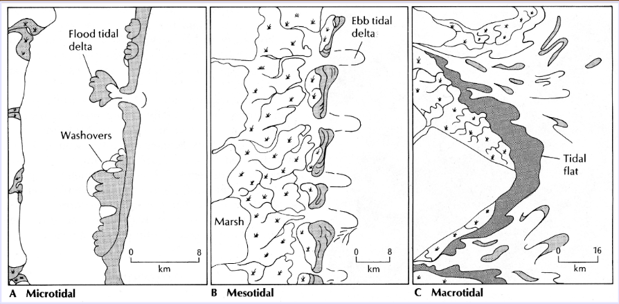
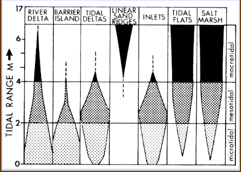
Tidal sizes
Microtidal < 2m (river deltas, barrier islands; wave-dominated)
Mesotidal 2 - 4m (tidal deltas and inlets; mixed energy)
Macrotidal > 4m (offshore linear sand ridges; tide-dominated)
Most important control on geomorphology of depositional coasts
Amount of hydrologic energy. Wave and tidal energy are included
Fetch
average velocity and duration of onshore winds in a given area. Wave energy varies according to this
Currents
Longshore - directed parallel to shore
Oblique - directed oblique to shore
Onshore - residual onshore movement from waves
Coastal dunes
Form ridges that lie parallel to shoreline and can build up to 10m high and 100s of meters inland. Commonly form along coasts w/ barrier island system
Coastal plain
Low-lying areas adjacent to seas. Include continental processes as well as marine flooding events
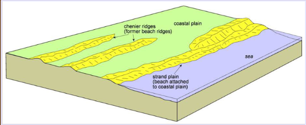
Strand plain
Sandy coastlines where an extensive area of beach deposits lie directly adjacent to the coastal plain. Composed of sediment deposited on the foreshore and backshore
Foreshore
Intertidal zone extending from mean high-water to mean low-water, corresponding to the wave swash zone. Mainly parallel laminae

Backshore
Inundated during very high tides (supratidal) and storms. Dominated by periodic storm-wave deposition and aeolian sand transport and deposition; sediment layers dip landward. Separated from foreshore by a berm
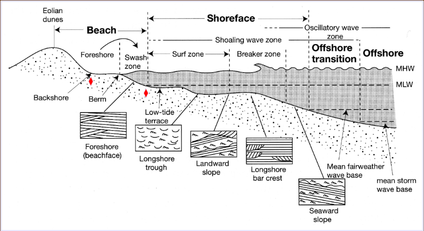
Shoreface
subtidal zone that extends from mean fair-weather wave base to mean low-water. Zone of maximum sediment movement

Upper shoreface
Trough cross beds and low-angle bidirectional cross beds. Skolithos common

Middle shoreface
Landward dipping ripple cross laminae; seaward-and landward-dipping trough cross-beds. Skolithos and Ophiomorpha common

Lower shoreface
Lower energy conditions with fine sand and silt. Landward migrating ripples with sub-planar laminated bedding. Structures tend to be destroyed by bioturbation. Cruziana common

Offshore transition
Extends from mean SWWB to mean FWB. Alternating high and low energy conditions. Laminated HCS and bioturbation common. Cruziana

Prograding barriers (regressive)
Those that build out towards the sea over time. Result in series of ridges parallel to coastline (chenier ridges) that are relicts of former beaches
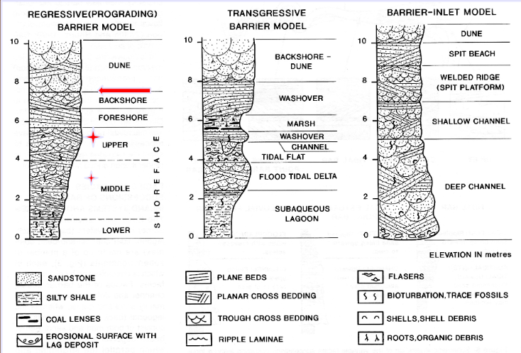
Retrograding barriers (transgressive)
Happen where sediment supply is too low to counteract erosional loss. Marsh behind the barrier will fill with sediment and the beach migrates landward
Coastline susceptible to sand wash-over during storms

Walther’s principle (coastal environments)
Facies belts that are in order laterally and stacked vertically during transgression or regression
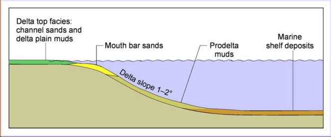
Delta
Where rivers enter bodies of water and supply sediment more rapidly than they can be redistributed by basinal processes. All river influenced, regressive
Moat sediment is river-derived; upward coarsening due to outward progradation
Bayhead delta
Occur within estuarine/lagoon systems. May be associated with transgression
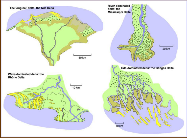
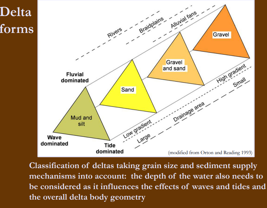
Influences on delta facies (forms)
size and discharge of river
wave energy
tidal currents
longshore drift
grain size
depth
fluvial (rare), wave, or tidal-dominated
Tidal range (deltas)
determined by the local receiving basin’s shape
Wave activity (deltas)
influenced by climate and size of water body
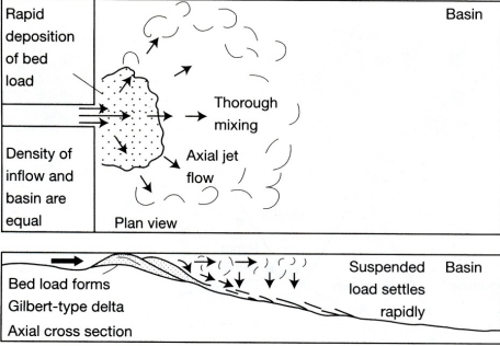
Hyperpycnal (seasonal flow)
Water density of river > receiving basin; coarse sediment immediately settles onto the bottom of the basin from the river. Common during floods. Forms turbidites
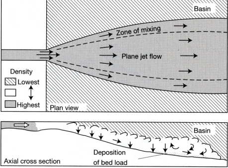
Homopycnal
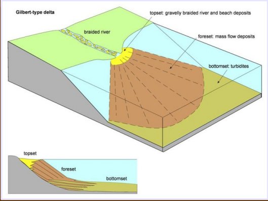
water density of river is about equal to receiving basin; sediment plumes out and mixes with the water column before settling. Gilbert coarse-grained type; topset, fore-set, and bottomset; dips 10-20 degrees
Hypopycnal
water density of river < receiving basin; freshwater floats on more dense saline water and drops fine grained sediment into the basin. Most common, dips < 1 degree
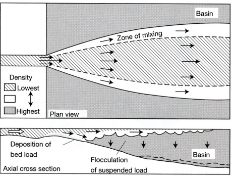
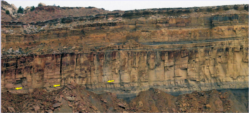
Clinoforms
inclined, basinward-dipping sedimentary strata representing ancient, sloping delta fronts (5-7 deg). Shows progradation of delta bedding planes
Lower delta plain
marked by tidal incursions of marine water

Upper delta plain
distributaries occur but in there is no incursion of marine water

Subaqueous delta plain
lies seaward of the lower deltaic plain below low-tide water level

Delta front
The upper 10 m or so of the subaqueous delta. Mostly sand
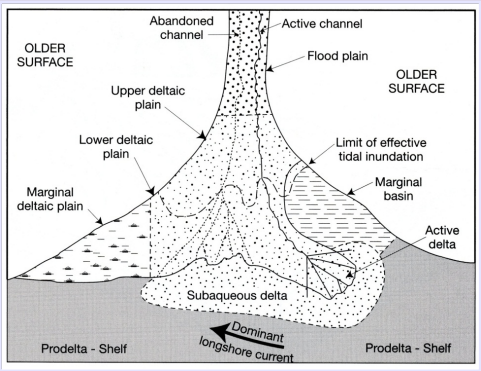
Prodelta
Beyond and below this the subaqueous delta. Silty mud

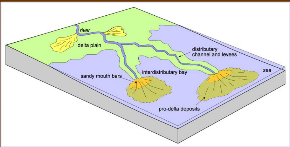
Distributary mouth bar
delta front immediately forward of the channel mouth; site of deposition of the bedload material (mud). Scale with flow width and can accrete downstream, laterally, upstream
Gilbert delta
High gradient mountain streams empty into a body of water. Coarse grained topset is subaerial to shallow water, delta front (foreset) is distinctive from steep dip (30 deg), and fine-grained bottom set flattens out
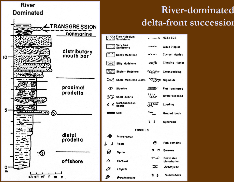
River-dominated delta
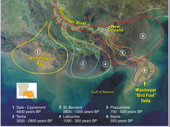
Microtidal regime; wave energy is dissipated before waves reach the coastline. largely controlled by fluvial processes and unidirectional flow. Gentle gradient causes channel instability and avulsion; results in many abandoned lobes that overlap
Compensational stacking
Sediment flow migrates to topographical lows, smoothing out relief and compensating for previous localized deposition
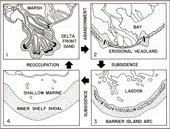
Abandonment facies
Beds that mark end of sedimentation on a delta lobe. Delta plain turns to peat while the delta front and mouth bar may be reworked by wave action, retreating landward in a series of sand shoals. Carbonate may develop on outer edge
low sedimentation rate
Shelf edge delta
Form at sea level low-stands and preserve upward coarsening. Often unstable and develop growth faults (slip with sediment deposition). Controlled by subsidence along these faults instead of wave action
After abandonment, a channel may develop into an
estuary; fill is commonly transgressive w/ tidal indicators. Upward fining w/ river sequences at base and marine in upper part of channel fill