DIVERGENT AND TRANSFORM BOUNDARIES
1/21
There's no tags or description
Looks like no tags are added yet.
Name | Mastery | Learn | Test | Matching | Spaced | Call with Kai |
|---|
No analytics yet
Send a link to your students to track their progress
22 Terms
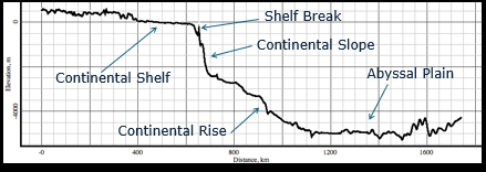
Hypsographic curve
A hypsographic curve is a graph that shows how much of Earth’s surface lies at each elevation (for land) or depth (for the seafloor)
Continental margins: Shallow-water areas close to shore(A continental margin’s visible shoreline and where shallow shelves end change when sea level rises or falls because the waterline moves across the continental slope and shelf. BUT DOES NOT CHANGE THE CONTINENTAL MARGIN, erosion, sedimentation, and tectonics do that)
Deep-ocean basins: Deep-water areas farther from land
Mid-ocean ridge: Submarine mountain range
→Amount of Earth’s surface (%) at different elevations and depths
→70.8% of Earth covered by oceans
→Uneven distribution of areas of different depths/elevations
Continental Margins
Transform Active Margin (A lot of earthquakes)
-Associated with transform plate boundaries
Ex: Coastal California along San Andreas fault or the Alpine Fault in New Zealand
PASSIVE
Not close to any plate boundary
No major tectonic activity
Ex: east coast of the United state
Active
-Associated with convergent or transform plate boundaries
-much tectonic activity
Convergent Active Margin
-Oceanic-continental convergence
-Ex: Western South America
SELF NOTES:
Active margin — a margin with lots of tectonic activity; includes both convergent and transform plate boundary settings.
Transform active margin — an active margin where plates slide past each other; lots of shallow earthquakes; examples: California (San Andreas) and New Zealand (Alpine).
Convergent active margin — an active margin where an oceanic plate meets and dives beneath a continent; strong tectonics, mountain building, and frequent large quakes; example: western South America
Continental Vs Oceanic Crust
Oceanic is thinner and less dense. It sinks and loses.
Suture
When an oceanic plate meets a continental plate, the dense oceanic plate usually sinks (subducts) beneath the continent, making a trench, an accretionary wedge of scraped sediments, and a volcanic arc on the continent above the down‑going slab
Subduction removes the oceanic plate; continental edges come together and collide.
Rocks at the boundary get crushed, folded, and welded into a complex zone.
The suture preserves bits of the old ocean (like ophiolites) and the record of the collision.
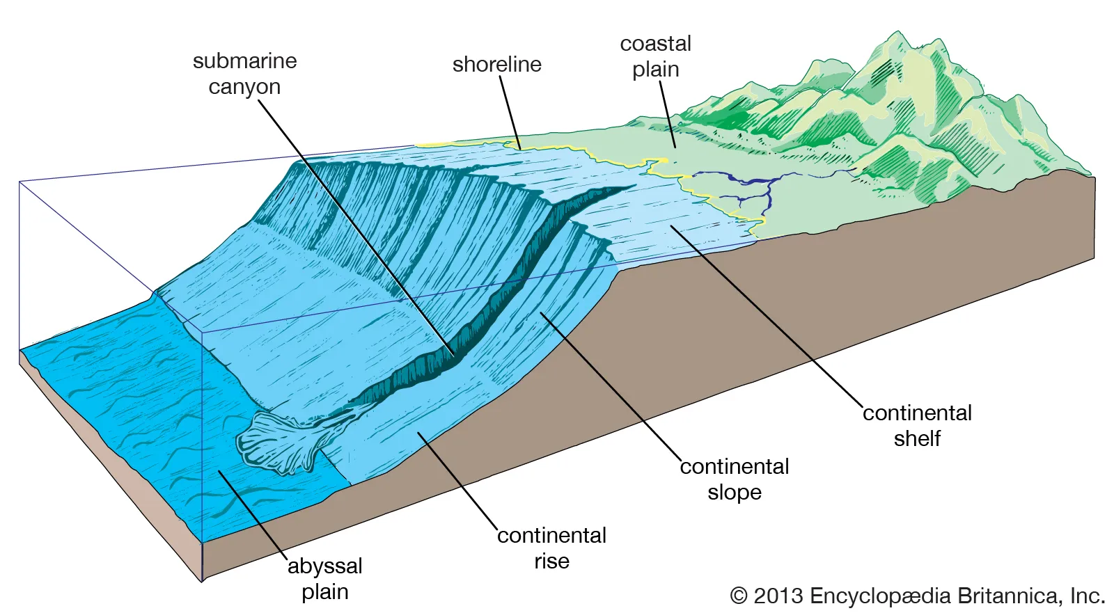
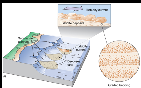
Continental Slope and Submarine Canyons
The continental slope is the steep drop from the shallow shelf down to the deep ocean; submarine canyons are deep, narrow valleys cut into the shelf and slope that act like underwater channels; a big outpour of sediment means lots of sand, mud, and rock rushes down those canyons—often during storms, floods, or underwater landslides—and is carried by fast, muddy flows (turbidity currents) to pile up on the deep seafloor.
Shelf = shallow, nearshore area.
Slope = steep drop-off.
Canyon = underwater valley that funnels sediment.
Big outpour = large amount of sediment moving down the canyon to the deep ocean.
Hypsographic Curve
A hypsographic curve is a graph that shows how much of Earth’s surface lies at each elevation or depth, with the horizontal axis showing area (or percent of Earth) and the vertical axis showing height above sea level or depth below sea level
EX: East Coast of U.S
Multi-Beam Bathymetry
Multi-beam bathymetry is a method that uses a ship-mounted sonar fan to measure the depth and shape of the seafloor quickly and in high detail.
Monterey Bay
Monterey Canyon is comparable in size to the Grand Canyon
Monterey Bay sits on California’s active margin where the San Andreas transform system is part of the plate‑boundary network that makes the coast earthquake‑prone; transform faults like the San Andreas slide plates past one another and produce shallow, frequent earthquake
Deep Ocean Basin Features
•Abyssal plains
•Volcanic peaks
•Ocean trenches
•Volcanic arcs
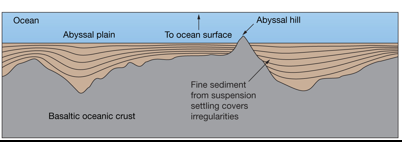
Abyssal Plains
•Very flat depositional surfaces from base of continental rise (These are huge, nearly flat parts of the deep seafloor that sit beyond the continental slope where sediments settle and pile up over a long time. Think of a giant underwater plain made by layers of sand and mud slowly filling low spots.)
•Suspension settling of very fine particles (Tiny bits of clay and silt float in the ocean water and very slowly settle down through the water column until they land on the seafloor. Over time those slow‑falling particles build thick, smooth layers that help make the plain flat.)
•Sediments cover ocean crust irregularities (The ocean floor is uneven from old volcanic ridges and bumps, but continual sediment rain fills the hollows and smooths the highs and lows)
•Well-developed in Atlantic and Indian oceans
-These oceans have wide, passive margins with lots of fine sediment coming from rivers and long gentle slopes, so their abyssal plains are especially broad and smooth.
Spreading centers (mid-ocean ridges) produce large amounts of basalt.
Abyssal Hill: not infilled by sediment because of copious amount of basalt erupted; rises from seafloor
A depositional surface is a flat or gently sloping place where sediment settles and piles up.
Suspension is when tiny bits of rock, silt, or clay float in water instead of sinking right away.
Volcanic Peaks
Poke through sediment cover
Below sea level:
•Seamounts, tablemounts, or guyots (all the same thing) at least 1 km (0.6 m) above sea floor
•Abyssal hills or seaknolls are less than 1 km height above sea level
Above sea floor:
•Volcanic islands
A volcanic peak is a single mountain made by volcanic eruptions. Lava, ash, and broken rock build up around one vent until a hill or cone forms. Examples: a single island volcano or a lone mountain like Mount Kilimanjaro’s volcanic cone.
Ocean Trenches
Linear, narrow, steep-sided
Associated with subduction zones
Deepest parts of the ocean
•Mariana Trench, 11,022 m (36,161 ft)
Most are in Pacific Ocean
Ex: Mariana Trench- consuming Oceanic lithosphere, plates going under other plates.
Also, Ring of fire- has subduction (consumption of pacific plates)
An ocean trench is a very deep, narrow valley on the seafloor where one tectonic plate is being pushed down under another. Trenches mark the location of subduction, are the deepest ocean places, and sit next to volcanic arcs.
Oceanic Trenches and Volcanic Arcs
Landward side of ocean trench
Island arc
•Chain of islands, e.g., Japan
Continental arc
•Volcanic mountain range, e.g., Andes Mountains
India and Asia plate used to have subduction, but it mushed together (basalt and limestone indicate there was an ocean there)
Oceanic Vs Continental Crust and Others
Continental always goes on top/always wins.
o vs o: gets island arc
o vs c: continent wins
c vc c (collision)
Subduction
Subduction is when one tectonic plate dives down and slides under another plate into the Earth’s mantle, like one sheet of stiff paper slipping beneath a second sheet.
AT CONVERGENT BOUNDARIES
ALWAYS makes mountains and sometimes volcanoes
Trenches along the coast are associated with mountains because of pushing (compression)/ uplifting it. The heat makes its buoyant.
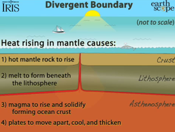
Sea Floor Spreading
•Harry Hess (1962)
•Mid-ocean ridge site of new ocean crust
•Oceanic trench site of crust destruction (subduction) (An oceanic trench is a very deep, narrow valley on the seafloor where one tectonic plate bends and dives down beneath another plate. At that place the oceanic crust is pulled into the Earth and melted or mixed into the mantle, so the trench is where old ocean crust is destroyed by subduction)
(Because plate area is conserved over long times, the new crust created at ridges must be removed somewhere else; that removal happens where oceanic plates dive back into the mantle at subduction zones and trenches, so spreading and subduction are complementary parts of the plate‑tectonic cycle)
Ex: Mid-Atlatlic Ridge
Divergent Boundary Photo
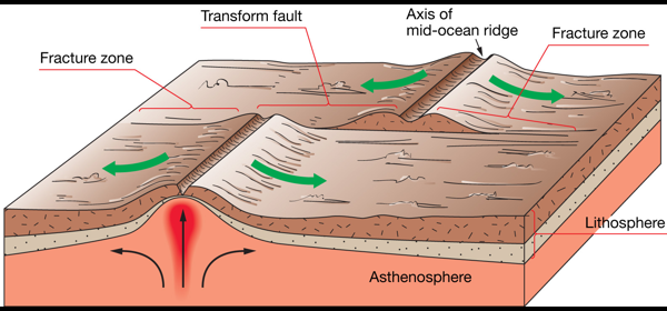
Rift Valley, Faults, and Fissures
Oceanic ridge
•Prominent rift valley
•Steep, rugged slopes
•Example: Mid-Atlantic Ridge
Oceanic rise
•Gentler, less rugged slopes
•Example: East Pacific Rise
•Down-dropped rift valley at central crest (A down-dropped rift valley is the low central groove that forms along the top of a mid-ocean ridge where the crust is being pulled apart. Rock on either side stays higher while the middle block sinks a bit, making a long narrow trench along the ridge axis)
•Cracks (fissures) and faults are common (Cracks called fissures form when the pulling stretches and breaks the crust; magma can reach the surface through these fissures and make new volcanic rock.)
In the photo, it is a shield volcano
-Buoyant ascending mantle
-HOT but not melting. When you BREAK it OPRN, lava can flow out
Fault
A fault is a crack in Earth’s crust where rock on one side moves relative to rock on the other side.
Mid-Ocean Ridges
Longest mountain chains
Average height is 2.5 km (1.5 miles) above surrounding sea floor
Wholly volcanic
Lava forms a rock called basalt
Divergent plate boundary
Transform Boundaries
Plates that scrape past one another are joined across a transform fault (fault: break + relative motion) (a fault is a crack in Earth’s crust where the two sides actually move against each other)
These faults extend to the base of the lithosphere. (he break goes deep, all the way through that rigid layer, not just in the shallow rock near the surface)
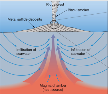
Hydrothermal Vents
Heated subsurface seawater migrates through cracks in ocean crust (places on the seafloor where very hot water comes out from cracks in the ocean crust.)
Warm-water vents < 30oC or 86oF
White smokers > 30oC < 350oC or 662oF
Black smokers > 350o
Dissolved metals precipitate to form metal sulfide deposits (Hot vent water contains metals dissolved; when that hot water meets cold seawater the metals stop staying dissolved and turn into solid particles. These solids build up around the vent as dark chimney‑shaped piles and mineral layers called metal sulfide deposits)
Unusual biological communities
•Able to survive without sunlight
•Archaea and bacteria oxidize hydrogen sulfide gas to provide food
Precipitate: dissolved substance becomes a solid
Volcanoes Mentioned (Class Notes)
Stratovolcano: 60% siO²; andesite
Shield volcano: 50% siO²