Hazards
1/105
There's no tags or description
Looks like no tags are added yet.
Name | Mastery | Learn | Test | Matching | Spaced | Call with Kai |
|---|
No analytics yet
Send a link to your students to track their progress
106 Terms
responding to hazards - fatalism
accepting that hazards are natural events part of living in an area
action is direct + concerned with safety
losses accepted as inevitable
people remain where they are
responding to hazards - adaptation
people accepted that natural events are inevitable
start changing behaviour according so that losses are kept to a minimum
best option for people + governments
responding to hazards - prediction
technology increases + the ways we predict hazards become more sophisticated eg. seismic monitoring on a volcano
advance in communications allows warning to reach a greater number of people + faster
geophysical hazard
caused by land processes, majorly tectonic plates eg volcanoes
atmospheric hazards
caused by atmospheric processes + conditions created from these, such as weather systems eg wildfires
hydrological hazards
hazards caused by water bodies and movements eg floods
factors affecting viewpoints of hazards
wealth - more wealth may perceive a hazard as smaller as they are less vulnerable, could view as greater due to more risk of property damage and financial loss
experience - more experience of hazards more likely to understand the full effects, also could be more likely to have an optimistic and unrealistic outlook on future hazards
education - more educated may understand their full effects + understanding how devastating they can be
religion/beliefs - may belief God is behind the hazards so may not view them as negative
mobility - those with limited access to escape a hazard may perceive them as greater threats than they are
mitigation of hazards
strategies to lessen the severity of a hazard eg sandbags preventing impact of flooding
management of hazards
strategies to reduce a hazards effects (prediction, adaptation, mitigation)
risk sharing
form of community preparedness, where the community shares the risk posed by a natural hazards + invests collectively to mitigate the impacts of future hazards
incidence
frequency of a hazard, how often it occurs
intensity
the power of a hazard, how strong it is + how damaging the effects are
magnitude
the size of the hazard, usually how its intensity is measured
pressure and release model - root causes
underlying causes
well-established, economic, demographic + political processes within a society
give rise to vulnerability over time
affects the allocation + distribution of resources between groups of people
reflect the distribution of power in a society + are connected to the functioning and power of the state
pressure and release model - dynamic pressures
processes and activities that transform the effects of root causes into vulnerability
channel root causes into forms of insecurity that have to be considered in relation to the types of hazards facing vulnerable people
included reduced access to resources as a result of the way regional/global pressures work through to localities
eg. lack of training/skills/freedom/ethical standards/investments
pressure and release model - unsafe conditions
specific forms in which peoples vulnerability is expressed in time and space in conjunction with a hazard
may occur through processes such as fragile local economic conditions, lack of disaster planning and preparedness and a harmed environment
eg. fragile physical environment, fragile local economy, vulnerable society, public actions
definition of a natural hazard
a potentially damaging physical event that is perceived to be a threat to people, the built environment and the natural environment
can cause loss of life, property damage, social/economic disruption
Degg’s model
A natural hazard only becomes a disaster when it causes significant impact on a vulnerable population
World Risk Index
helps define the interaction between natural hazards + vulnerability
measures degree of exposure to hazard events + combines this with vulnerability
measured by degree of susceptibility, coping capacity + ability to adapt in long-term of communities
factors affecting impacts of natural hazards
location
proximity to urban areas
population size
magnitude of the hazard
development of country
frequency of the hazard
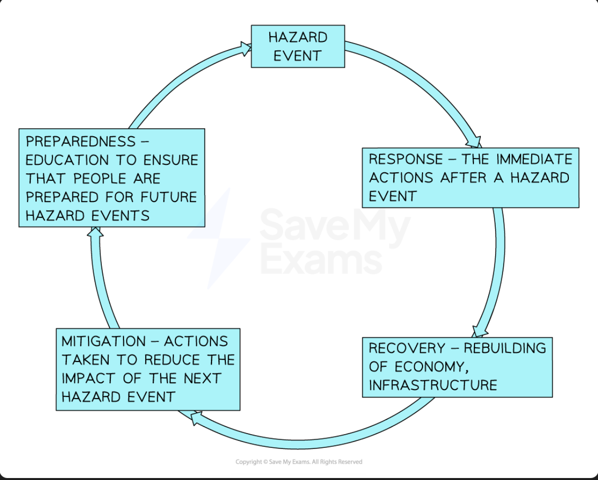
Hazard management cycle
shows how the events of one hazard event inform planning + preparation for the next hazard event
time of each stage depends on:
level of development
magnitude of hazard
quality of governance
aid available
stages of the hazard management cycle model
response - immediate actions, search&rescue, emergency aid
recovery - rebuilding economy + infrastructure, restoring services
mitigation - actions to reduce the impact of the next hazard event eg. flood barriers, setting up early warning system
preparedness - education to ensure that people are prepared for future hazard events eg. earthquake drills, public awareness campaigns
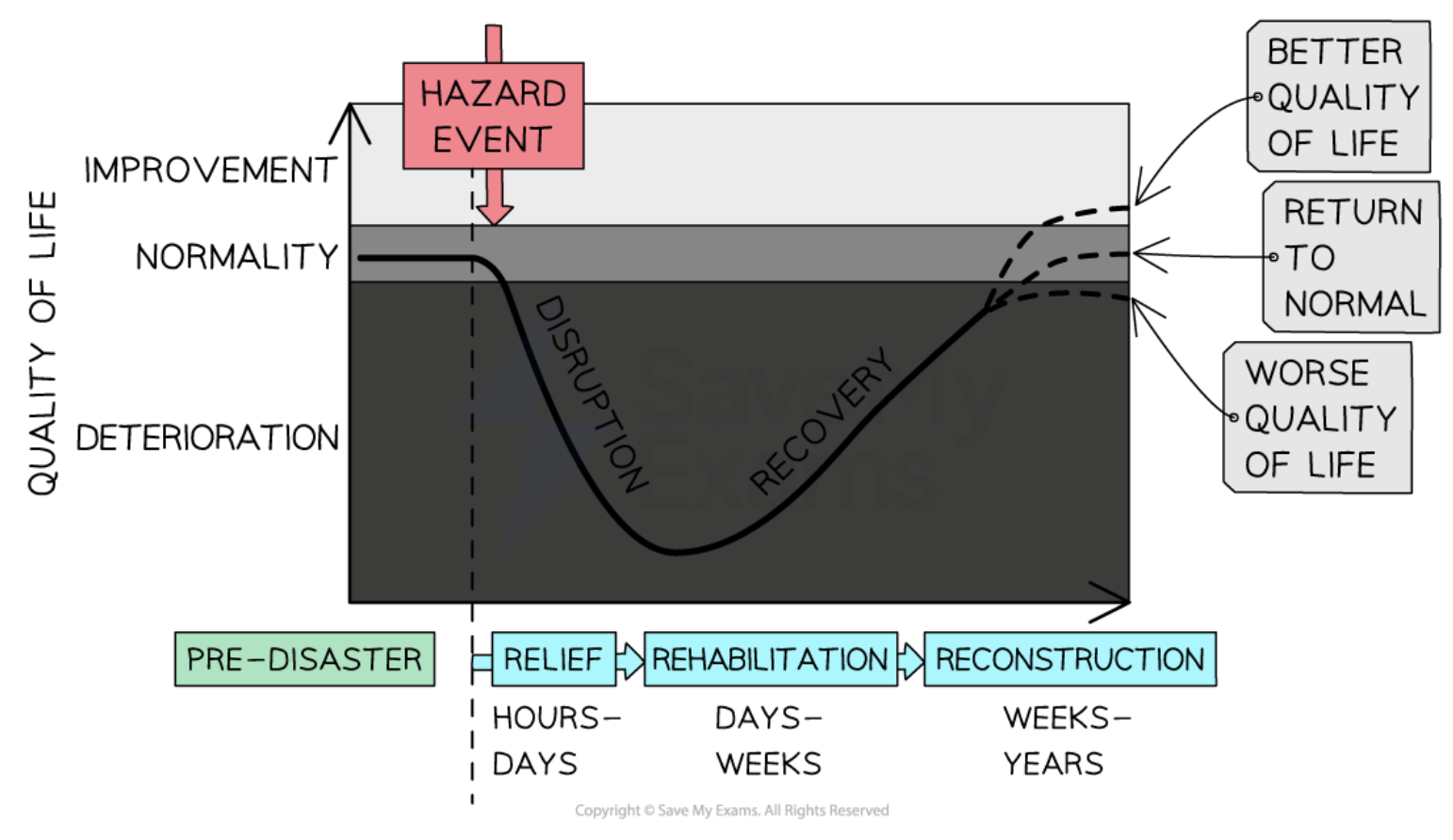
Park Model of Human Response
shows how people’s quality of life is affected by hazards
outlines how people respond to hazard events
downward curve of disruption varies depending on nature + magnitude of the hazard (high mag+sudden event = steeper/deeper curve)
upward curve of recovery depends on:
preparation + planning
development
national and international aid
phases of the Park Model
relief - immediate response including search&rescue, provision of emergency medical aid
rehabilitation - includes temporary restoration of services/infrastructure eg. temporary schools and shelters
reconstruction - permanent restoration aiming to provide the same/improved quality of life than before eg. aseismic designs
typical Park Model for lowly developed countries
LDE countries may have a worse initial impact of the hazard event due to lack of preparation and planning
Search and rescue takes longer due to lack of equipment and training or waiting for international assistance to arrive
Recovery + rehabilitation takes longer due to lack of money, corruption, poor governance
Quality life may take longer/may never return to the normal
layers of the earth
crust
mantle
outer core
inner core
magma
molten rock, gases + liquids from the mantle accumulating in vast chambers at great pressures deep within the lithosphere
once it reaches the surface = lava
igneous rocks
formed by the cooling of molten magma, either underground or on the ground surface
intrusive igneous rocks
cooling of molten magma underground
forms coarse-grained igneous rocks eg. granite
vertical/horizontal dykes or incline sills may become part of the landscape once erosion removes the underlying rocks
extrusive igneous rocks
cooling+crystallising+solidifying of magma on the ground surface
solidifies far quicker than magma underground
fine-grained igneous rocks with small crystals eg. basalt
Mohorovičić discontinuity
boundary between the crust and the mantle
Gutenberg discontinuity
boundary between core and mantle
lithosphere
crust + rigid upper section of the mantle
broken up into plates
only the top is the crust, majority is within the mantle
asthenosphere
beneath the lithosphere, semi molten part of the mantle on which plates move
movements powered by heat from core
inner core temp + distance from earths surface
5000°
5000-6370km
characteristics of the inner core
solid - nickel/iron alloy(80%)/platinum group elements
radius 1200km
2% of Earth’s total mass
during Earth’s formation, melting caused denser substance to sink towards the centre, less dense migrated to the surface
outer core temp + distance from earths surface
4000-5000°
2900-5000km
characteristics of the outer core
semi-liquid - nickel-iron alloy, 10% sulphur + oxygen
radius 2250km
30% of Earth’s mass
density 10-12.3 g/cm3
characteristics of the core
supply of heat to the Earth
heat comes from decay of radioactive substances eg. uranium,
heat is responsible for moving material in the mantle
outer + inner core cause Earth’s magnetism because the outer core spins whilst the inner core doesn’t
lower mantle temp + distance from earths surface
2000-3000°
1000-2900km
characteristics of the lower mantle
mesosphere
solid rock
41% of Earth’s mass
composed of different oxides with increasing iron content with depth
upper mantle temp + distance from earths surface
1000°
base of crust-400km
characteristics of the upper mantle
lithosphere + aesthenosphere
semi-molten magma
10% of Eath’s mass
density = 3.25-3.40 gm/cm3
composition - changes with depth
types of crust
oceanic crust - thin but dense
continental crust - thicker but less dense
main sources of Earth’s internal heat
radioactive decay of elements such as uranium and potassium inside the earth’s core
heat left over from collisions of asteroids and other small bodies which resulted in the formation of Earth
plate tectonic theory
the lithosphere is broke into large slabs of rock called tectonic plates
these move due to convection currents in the asthenosphere
plate boundaries/margins = edges of plates where they meet
continental drift theory
Alfred Wegener - believed that earth’s continents had once been a single landmass, the continents had gradually drifted apart over millions of years
movement of tectonic plates due to varying weights of crust
originally thought that convection currents causes the movements of the plates, but now slab pull is thought to be the primary force
convection currents
circulation of magma within the asthenosphere
magma heated by radioactive processes sin the core and cools at the surface, and so circulates between the two places
slab pull
force contributing to the movement of tectonic plates
as the denser plate subjects, gravity pulls it down into the mantle
subduction zone
formed when two plates move towards each other
ridge push
at constructive plate margins, magma rises to form new crust
the heat from the magma heats surrounding rocks, making them expand and rise above the surface forming a slope
new crust cools and becomes denser
gravity causes denser rock to slide downhill → puts pressure on plates and causes them to move apart = gravitational sliding
mid-ocean ridge
parting oceanic plates at a constructive plate boundary create a ridge, with new land at the base of the oceanic valley
magma rises to fill gap, accumulates over time to become taller + wider
eg. Mid Atlantic Ridge
rift valley
forms when diverging plates are beneath land
as plates move apart, the crust stretches and fractures
areas of crust drop down between faults to create a valley
eg. East African Rift Valley
ocean trench
at destructive plate boundaries
oceanic crust subducts continental
creates long narrow deep compression = a trench
eg. The Mariana Trench
fold mountains
at destructive plate boundaries
during subduction, the plates collide and compress/push up sedimentary rock = fold mountain
eg. The Andes
sea floor spreading
proof of existence that the sea floor has gradually moved apart at a mid-ocean ridge
lava cools and solidifies with the minerals lining up with the magnetic field
direction of the minerals on either side is a mirror image
island arc
at ocean-oceanic destructive plate boundaries
convection currents involved in the process
heavier plate subducts under the lighter one, slab pull causes it to be dragged down into the mantle
subduction causes melting in the mantle → produced silica rich magma that rises and cools and over time accumulates to form volcanoes above sea level in an arc like shape
eg. Ryuku Islands south of Japan
destructive plate boundary + landforms/processes created
plates moving towards each other
continental-continental = earthquakes + fold mountains
oceanic-oceanic = earthquakes + volcanoes + island arcs + ocean trenches
continental-oceanic = earthquakes + volcanoes + fold mountains
constructive plate boundary + landforms/processes created
plates moving away from each other
continental-continental = earthquakes + volcanoes + rift valleys
oceanic-oceanic = earthquakes + volcanoes + ocean ridges
conservative plate boundary + landforms/processes created
plates moving parallel to each other
earthquakes
continental-oceanic destructive plate boundary
denser oceanic plate subducts below continental - leaves ocean trench
when sediment is pushed up during subduction = fold mountaIn
ocean crust is melted into the asthenosphere → extra magma created causes pressure to build up
pressurised magma forces through weak areas in continental plate = composite volcanoes
oceanic-oceanic destructive plate boundary
heavier plate subducts + leaves ocean trench + fold mountains
built up pressure causes underwater volcanoes bursting through oceanic palte
lava cools and creates island arcs
continental-continental destructive plate boundary
both plates aren’t as dense as oceanic so lots of pressure builds
older oceanic crust is subducted, but not subduction of continental crust
pile up of continental crust on top of lithosphere due to pressure between plates
fold mountains formed from piles of continental crust
oceanic-oceanic constructive plate boundary
magma rises between the gap left, forming new land when it cools - ocean ridge
less explosive underwater volcanoes formed as magma rises
sea floor spreading = new land formed on ocean floor by lava filling the gaps
continental-continental constructive plate boundary
land in the middle of the separation is forced apart - rift valley
volcanoes form where the magma rises
the gap eventually most likely fills with water
conservative plate boundary - any crust
parallel plates move in different directions or at different speeds
no plates destroyed so no landforms creates'
when they move, lots of pressure built up
oceanic - can displace a lot of water
continental - fault lines can occur where the ground is cracked by the movement
hotspots
areas of volcanic activity not related to plate boundaries
hot magmas plumes from the mantle rise and burn through weaker parts of the crust → can create volcanoes and islands
the plume remains in place but the plates continue to move → can create a chain of Islands (eg. Hawaii)
magma plumes
upwellings of superheated rock that rise from deep within the Earth’s mantle towards the surface
can break through the middle of a tectonic plate to reach the surface causing volcanic activity and earthquakes far away from plate margins
eg. Hawaiin hotspots
distribution of volcanic hazards
most active volcanoes at or near plate boundaries
75% occur around the Pacific Ocean ‘Ring of Fire’
also found at hotspots
volcanic eruptions at constructive margins
eruptions usually small
usually basaltic lava
volcanic eruptions at destructive margins
eruptions tend to be explosive
often andesitic or rhyolitic lava
basaltic lava
hot (1200°C) + runny, low viscosity
low silica content
flows as rivers of molten rock
keeps gas content → more mobile
produces extensive, gently sloping landforms
gentle but frequent eruptions
lava + steam ejected
eg. Mid Atlantic Ridge
andesitic lava
cooler (800°C), more viscous
high silica content
flows slowly + short distances
loses gas quickly → more viscous
produces step-sided localised features
less frequent but more violent eruptions due to gas build up
pyroclastic + steam + lava ejected
eg. Mt St Helens
Rhyolitic lava
lowish tempts (650-900°C)
very vicious and sticky, very high silica
magma traps gas + coagulates up in the vent of the volcano
pressure builds over time until suddenly released in catastrophic eruption
flows slowly + can damage property
larger explosive eruptions = highly dangerous
magnitude of volcanoes
measured using Volcanic Explosivity Index
more powerful = more explosive
0-8 scale
factors considered: how long it lasts, how much material is erupted, how high material is ejected
explosive eruptions
intense, high magnitude eruptions
lower frequency
effusive eruptions
calmer, lower magnitude eruption
higher frequency
frequency of volcanic eruptions
varies per volcano
classified as active, dormant or extinct
estimates 50-60 volcanoes erupt each month
classification of volcanoes eruption
active - have erupted in living memory
dormant - have erupted within recorded history
extinct - will not erupt again
regularity of volcanic eruptions
each type of boundary are similar
eruptions on destructive boundaries will regularly be explosive
sometimes eruptions may be irregular and not fit patterns
predictability of volcanic eruptions
regularity can help estimate when eruptions will take place
seismic activity, gases releasing, elevation etc - can indication an eruption
no definite predictions
tephra
large pieces of rock ejected from the volcano
crater
opening at the top of a volcano
volcanic cloud
gas, steam and ash escaping from the volcano
secondary vent/cone
allows magma to escape from the side of the volcano
lava flow
allows magma to escape from the side of the volcano
ash and lava
build up overtime to form sides of the volcano
main vent
the tunnel in which magma rises to the top of the volcano
fissure volcano
hollows in existing landscapes are filled to create flat, featureless basaltic plains
eg. Deccan Traps
shield volcano
typical of constructive plate boundaries and hotspots
volcanic cone
eg. Hawaii and Iceland
dome volcano
typical of destructive plate boundaries
pyroclastic flows are common
eg. Mount Pelee, Caribbean - killed 30,000 within minutes
composite volcano
alternate layers of lava and ash causes weaknesses that can be exploited by magma
eg. Mount Merapi, Indonesia
caldera volcano
occurs when violent eruptions blow out the top of volcanoes summit, emptying the magma chamber so the sides collapse in
often the caldera is flooded by a sea or lake
eg, Santorini Greece
Disaster Risk Equation
Risk = Hazard x Vulnerability
eruption columns and clouds
explosive eruption blasts solid/molten rock fragments + volcanic gases into the air with tremendous force
volcanic ash in the cloud can post a serious hazard to aircraft
eruption clouds can extend hundred of miles downwind
heavy ash fall can collapse buildings
volcanic gases
emitted during eruptions
cracks in the ground allow gas to reach the surface, even when the volcano isn’t erupting = fumaroles
90%+ of gas emitted is water vapour
other gases = CO2, sulfur dioxide, hydrogen sulphide, hydrogen + fluoride
CO2 heavier than air so can get trapped in Lowe areas in concentrations that are deadly to humans and animals
fluorine is highly toxic in high concentrations
huge eruptions inject sulfur dioxide gas into stratosphere → forms sulphuric acid → reflects solar radiation and can lower earths surface temp
also contribute to destruction of ozone layer
pyroclasts
hot broken fragments of rock ejected with great velocity - can be very large
lava flows and domes
magma that pours/oozes onto the Earth’s surface
higher silica content = flows slowly
flows of andesitic + rhyolitic lava flow very slowly as get are thick
flows of basaltic lava can run fast and easily destroy homes