Looks like no one added any tags here yet for you.
Geography (definition)
The study of the interaction of all physical and human phenomena at individual places and of how interactions among places form patterns and organize space.
Physical geography
The study of the earth’s physical processes including how they work, how they affect humans, and are affected by humans.
Human geography
The study of various aspects of human life that create the distinctive landscapes and regions of the world.
What physical geographers study (sub-disciplines)
Geology, Physics, Chemistry, Biology, Botany, Meteorology
Examples of physical geographers: Climatologists, geomorphologists, water resource specialists
What human geographers study (sub-disciplines)
Anthropology, sociology, history, political science
Examples of Human Geographers: Cultural Geographers, Urban Geographers & Planners, Population Geographers, and Medical Geographers
Spatial relationships
The way objects are arranged in relation to one another in geographic space
Spatial analysis
An approach to geographic inquiry focusing on patterns and in the distribution of human actions, environmental processes and interactions among and between places or regions.
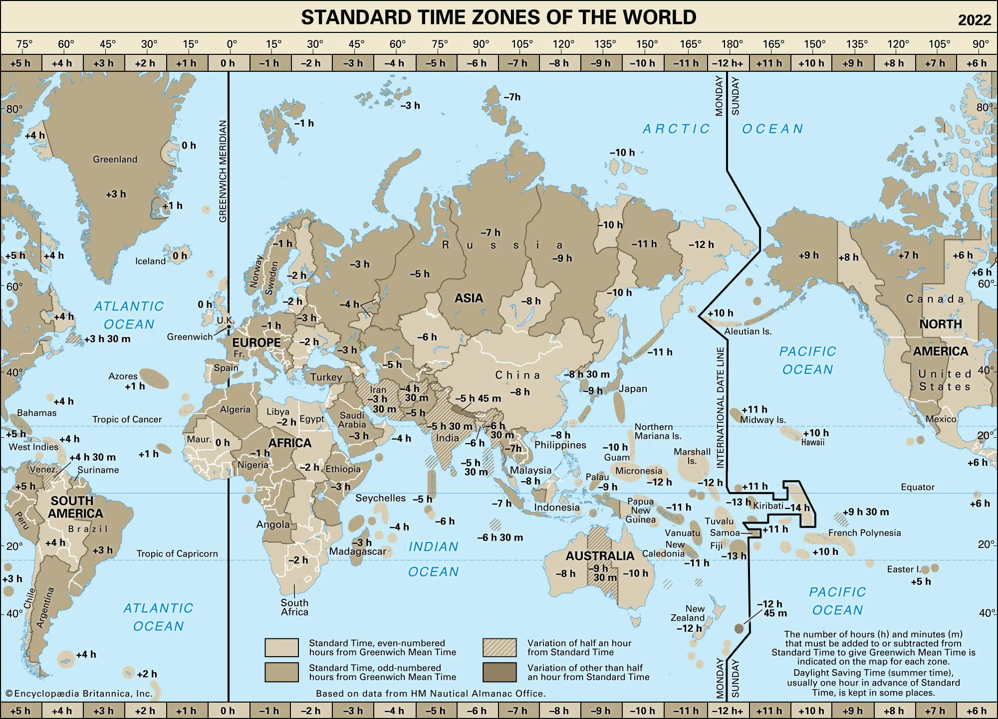
Mapping
Maps help geographers understand phenomena and their interactions
Maps can display ENORMOUS amounts of information.
Latitude (parallels)
Run east to west
Measure north to south
0° Latitude is the equator
Longitude (meridians)
Run north to south
Measure east to west
0° Longitude is the prime meridian
Equator
0° Latitude is the equator
Cuts the world in half with the northern hemisphere and southern hemisphere
The Tropics & other significant lines of latitude
Tropic of cancer (23.5 degrees N)
Tropic of capricorn (23.5 degrees S)
Prime meridian
0° Longitude is the prime meridian
Cuts the world in half with the eastern hemisphere and western hemisphere
Greenwich Mean Time (GMT)
The time measured on the Earth's zero degree line of longitude, or meridian
International date line
A boundary from which each calendar day starts
Map projection
All map projections entail some distortion between the 3-D sphere and the 2-D image.
Distortions of size, shape and location
Conic, Cylindrical, Planar
Conic
Good for mapping mid-latitude regions
Most common in our atlas
Cylindrical
Used for navigation
Exaggerates areas at higher latitudes
Planar
Embeddings of topological maps into the plane
Ssmall scale mapping
Less detail, large denominator (1:1,000,000)
Large scale mapping
More detail, small denominator (1:100,000)
Thematic maps
Show the spatial distribution patterns of physical or cultural phenomena.
Cartogram maps
A map in which some mapping variable other than acreage is used for scale.
Cartographers
The “art” of map making
Geographic Information Systems (GIS)
A computer system that captures, stores, queries, analyzes, and displays geographic data.
Remote sensing
Acquisition of data about the Earth surface from a satellite orbiting the planet.
Lithosphere
Earth’s Crust and upper mantle
Landform
Any natural formation of rock and dirt, found on Earth.
Geomorphology
Study of landforms and processes that create them.
Endogenic forces
Internal forces beneath or at Earth’s surface
Ex: Mountain building, Earthquakes, and Volcanoes
Exogenic forces
External forces
Ex: Chemical, Erosion: water & wind, Transport
Earth’s planetary structure
Inner core, outer core, mantle, crust
Inner core
Solid
1/3 of Earth’s mass
Enormous pressure
Iron and nickel
Outer core
Molten lava
Minerals
Natural substances that compromise rocks.
Distinct characteristics of minerals
Color
Luster
Specific Gravity
Hardness
Geometric shapes
Rocks
Most rocks consist of several minerals
Lithosphere building material
Bedrock and outcrop
Types: Igneous, metamorphic, sedimentary rocks
Bedrock
Is the solid rock that underlies loose surface material.
Outcrop
Is a mass of exposed bedrock.
Igneous rocks
Molten rock material that cools and solidifies
Metamorphic rocks
A rock that has changed form due to enormous heat and pressure
“Parent Rock” could have been igneous, sedimentary, or another metamorphic rock
Sedimentary rocks
Unconsolidated material that have been eroded and deposited, then compressed and cemented.
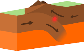
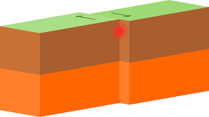
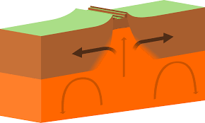
Plate tectonics
Movement of rigid “plates” of rock over a weak layer in the upper mantle.
The study of large-scale movement and deformation of the earth’s outer layers.
Theory of Continental drift
Continents and other landmasses have shifted their positions during Earth’s history
Convergent boundaries
One plate boundary pushes up and over another. This is how the Himalayas formed, between India and Asia.
Transform plate boundaries
Two plate boundaries shift against each other. The San Andreas fault and the Coastal range of California.
Divergent plate boundaries
Two plate boundaries pull apart from one another. The great rift valley of Africa or the red sea between Saudi Arabia and Africa.
Convection in the Earth’s upper mantle
The reason for the force in the Continental Drift
Volcanism
The rise of magma and its cooling at the Earth’s surface.
Includes the landforms formed by this process.
Shield volcanoes
Gently sloping, dome shaped cone
Hawaii Islands
Cinder volcanoes
Most common
Simple “construction”
Usually only one vent
Steep-sided cones
Composite volcanoes
Large and Explosive
Multiple vents
Death and destruction…if in a populated place
Sometimes called Stratovolcanoes
Plug (Lava) dome volcanoes
A mound that will form when lava piles up over a volcano’s vent instead of moving away
Mt. St. Helens
Earthquakes
Evidence of present-day tectonic activity
Ground motions of Earth caused when accumulating tectonic stress is suddenly relieved
Seismic waves
Epicenter
Aftershocks
Richter scale
Richter scale
Measurement of earthquakes
Weathering
The process of wearing or being worn by long exposure to the atmosphere
Mechanical weathering
Any way that rock is broken down into smaller pieces by mechanical (physical) processes
Chemical weathering
Turns the rock into something “different”
Karst landscapes
Underground erosion caused by water flow that dissolves passageways and carves large caverns in limestone
Erosion
The movement of weathered material
Mass wasting
The downslope movement of rock debris in response to gravity
Talus slope
Mitigation
Actions that limit, stop or reverse adverse affects of human activities on the environment
Fluvial geomorphology
Study of flowing water as a land-shaping process
Stream Meandering
Stream erosion
Floodplain
Nearly level surface at the valley bottom through which a river flows
Glaciation
Thick layers of moving ice
Terminal moraines
A moraine deposited at the point of furthest advance of a glacier or ice sheet
Lateral moraines
Sharp-crested piles of glacially-transported rocks and debris that are dropped by the ice as it melts
Medial moraines
Form where two tributary glaciers come together
Glacial deposits
The settling of sediments left behind by a moving glacier
Glacial cirque
An amphitheatre-like valley formed by glacial erosion
How v-shaped valleys are formed
Typically caused by stream or river erosion
How u-shaped valleys are formed
Formed through glacial erosion
Wind erosion landscapes
A significant shaper of landforms especially in dry regions
Loess plateau - China
Deposits of windblown material
Sand dunes formation
Where this sediment is deposited when wind velocities are lower.
Geographic Systems analysis
Geographic inquiry which views Earth as a set of interrelated environmental and human systems.
Atmosphere
A thin layer of gases surrounding Earth, composed of nitrogen, oxygen and other gases
Variances of solar energy based on 2 things
Intensity and Variation
Intensity
Angle of incidence
Variable
Season
Degree of tilt on Earths axis
23 .5 °
Angle of Incidence
The angle at which solar radiation strikes a particular place at any point in time
Earths orbital position at Winter Solstice
Directly over the Tropic of Capricorn, which is located at 23.5
Earths orbital position at Spring Equinox
Earth's 23.5° axis not tilting toward or away from the sun
Earths orbital position at Summer Solstice
The sun's direct rays reach their northernmost position with respect to Earth's equator, along the Tropic of Cancer, at 23.5 degrees north latitude
Earths orbital position at Fall Equinox
Perpendicular to the orbital plane at 23.5 degrees
Climograph
A graphic representation of the relation of two climatic elements
Wavelengths of solar radiation
Short and long wave
Urban heat islands
Sun gives off short-wave radiation
Earth emits long-wave radiation
Greenhouse gasses
Water vapor, carbon dioxide, ozone, methane
Water vapor
H2O
Carbon dioxide
CO2
Ozone
O3
Methane
CH4
Air density in atmospheric pressure
Heavier closer to the surface
The way wind blows around an area of high pressure
Blows away
The way wind blows around an area of low pressure
Blows toward
How the Coriolis effect affects global air movement
Deflection of wind above rotating Earth.
On a spinning planet, winds follow an indirect, curving path.
How the ocean currents warm the air and are circulated across the globe
Travels north or south and cools, then returns