Coasts
1/206
There's no tags or description
Looks like no tags are added yet.
Name | Mastery | Learn | Test | Matching | Spaced | Call with Kai | Chat |
|---|
No analytics yet
Send a link to your students to track their progress
207 Terms
What is the littoral zone?
the area of shoreline where land is subject to wave action
What is the coast?
the frontier between the land and sea. It is a dynamic interface in a constant state of flux, affected by both natural processes and human interference.
what sort of system is the coast and what is it powered by/ what are it’s inputs? x 3
the coast is an open system as both energy and materials can enter and leave the system and it is powered by the energy of waves, tidal currents and wind.
Which processes allow coastal inputs to interact with the system’s geological structure and sediments? x 3
erosion, transportation, deposition
What percentage of energy inputs comes from waves? - what are the waves doing? x 4
95% of energy inputs are from waves - used in breaking, friction, erosion, transport.
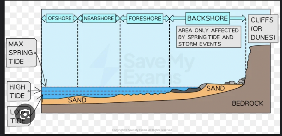
What is the littoral zone divided into?
(SILENCE) OKAY NOW FRY BANANAS!!
(sea)
offshore
nearshore
foreshore
backshore
describe the essential features of the offshore x 4
an area of relatively deep water. Almost never exposed, water more than 20m deep.
wave-induced sediment movement is limited
the point at which waves begin to break
Friction between the waves and the sea bed may cause some distortion of the wave shape.
describe the essential features of the nearshore x 4
vital to coastal morphology
waves enter and break as they move towards the shoreline. friction between the seabed and waves distorts the wave sufficiently to cause it to break. (breaker zone)
the area of shallow water near the low tide mark
often bars between this zone and the offshore
describe the essential features of the foreshore x 2
area delineated between low and high water mark
affected by the tidal range
describe the essential features of the back shore x 4
lies beyond the reach of the waves
often an area of sand dunes and old shingle ridges
only affected by wave action during large storm events
area closest to the cliff foot.
What are the 3 types of coastlines formed by the littoral zone?
rocky, cliffed
sandy
estuarine
what are the features of a rocky, cliffed coastline? x 3
where do they form?
example of one high and low relief
how much of the uk’s coastline do they occupy?
areas of high relief varying from a few metres to hundreds of metres in height.
usually form in areas with:
resistant geology,
in a high-energy environment,
where erosion is greater than deposition
destructive waves dominate.
micro-tidal range ( the smallest tidal range <2m) due to the continuous focused energy of the waves.
427 m Conachair Cliff on the Isle of Hirta in the Outer Hebrides
3m cliffs at Chapel Porth in Cornwall
occupy about 1,000 km of the UK's coastline, mainly in the north and west.
what are the features of a sandy coastline? x 3
where do they form?
areas of low relief with sand dunes and beaches, that are much flatter.
they usually form in areas with:
less resistant geology
a low-energy environment
where deposition > erosion
constructive waves
macro tidal range (big difference between high and low tide 4m+) this allows time for sediment to dry out and build up.
what are the features of an estuarine coastline?
where do they form?
Areas of low relief with salt marshes and mudflats (estuaries)
They form:
in river mouths
where deposition > erosion
in a low energy environment
usually in areas of less resistant rock
submerging/sinking coasts
Info about coastal plains:
what are they?
what do they contain?
where do they form?
what is coastal accretion?
where is the accumulation of sediment sourced from? x 2
what are the 2 types?
where in the UK are they connected?
What is an estuary?
Coastal plain landscapes are relatively flat, low relief areas adjacent to the sea.
They often contain freshwater wetlands and marshes due to the poor drainage of the flat landscape.
Their littoral zone is composed of sand dunes, beaches, mud flats and salt marshes.
Coastal plain landscapes form in low-energy environments where deposition > erosion, so they experience a net accumulation of sediment. They form through coastal accretion (a continuous net deposition of sediment.) This comes from:offshore sources (transported by waves, tides or current)
terrestrial sources (transported by rivers, glaciers, wind or mass movement)
Coastal plains may besandy coasts, composed of sands, shingles and cobbles.
estuarine (alluvial) coasts composed of mud (clays and silts)
They form most of the UK's south and east coastline.
An estuary is a partially enclosed area of water on the coast where saltwater from the sea mixes with fresh water from rivers and streams. The movement of tides causes coastal areas and estuaries to be either under water or exposed to the air at different times of the day.
What is a tide? high vs low?
Tides are long-period waves that appear to move through the oceans due to the gravitational forces exerted by the moon and sun. The gravitational pull of the sun or moon changes the water levels of the seas and oceans.
The alternating advance and retreat of seawater along a coastline
High tide is when water advances to its furthest extent onto the shoreline. Low tide is when it recedes to its furthest extent.
What are the three types of tidal ranges? + explain them
micro-tidal- smallest tidal range (<2m)
meso-tidal- a small difference between high and low tide (2-4m)
macro-tidal- big difference between high and low tide (4m+)
How does high tide affect erosion?
High tide brings deeper water close to cliff - less energy lost to friction before impact - increased erosion
spring tide
During full or new moons average tidal ranges are slightly larger. This occurs twice each month. The moon appears new (dark) when it is directly between the Earth and the sun. The moon appears full when the Earth is between the moon and the sun. In both cases, the gravitational pull of the sun is "added" to the gravitational pull of the moon on Earth, causing the oceans to bulge a bit more than usual. This means that high tides are a little higher and low tides are a little lower than average.
what are the four factors involved in the dynamic equilibrium of beaches?
the supply of sand
the energy of the waves
changes in sea level
the location of the shoreline
What is meant by dynamic equilibrium? x 3
when a system’s outputs and inputs of energy and matter balance.
a system will remain in a steady state for long periods of time.
Short changes will still occur but the system can adapt and adjust to these changes via negative feedback/
what are examples of long vs short-term changes of the coast?
There are also long-term changes, e.g. sea level variation due to climate change.
And short term changes (e.g. high and low tide variation over the lunar month; wave energy variation due to weather conditions)
Negative feedback example: beaches and waves
The presence of constructive waves causes deposition on the beach,
this in turn leads to the beach profile becoming steeper.
Steeper beaches favour the formation of destructive waves which are then more likely to occur.
The destructive waves erode the beach, reducing the beach profile and leading to the formation of constructive waves.
As constructive waves occur more frequently in summer when there are fewer storms,
this means that the beach profile is more gentle in summer and steeper during the winter months when destructive waves are more common.
This should lead to a state of dynamic equilibrium though in reality, this may not occur due to external factors such as the wind strength and direction.
negative feedback loop: sediment deposition
When the destructive waves from the storm lose their energy, excess sediment is deposited as an offshore bar.
The bar dissipates the wave energy which protects the beach from further erosion.
Over time the bar gets eroded instead of the beach.
Once the bar has gone normal conditions ensue and the system goes back to dynamic equilibrium.
how can human activities affect dynamic equilibrium? x 3
- Dredging of rivers to deepen them for shipping
- Dredging of offshore areas for sand and gravel (construction uses)
- building of coastal defences
classifying coasts- examples of long-term criteria that affect coastlines
Geology: all the characteristics of land, including lithology (rock type) and structure (arrangement of rock units). rock morphology- the external structure of rocks in relation to the development of erosional forms or topographic features. e.g. rocky, sandy, estuarine, or concordant vs discordant coastlines.
Sea Level Change: can be used to classify coasts as emergent or submergent.
This can be caused by:Tectonic processes which can lift sections of land up, causing local sea fall, or lead sections of land to subside, causing local sea rise.
Climate change causes sea levels to rise and fall in a 100,000-year cycle due to the change in the Earth's orbit shape.
sea levels fall for 90,000 years during glacials as ice sheets expand and rise for 10,000 during interglacials
sea levels rise even more when the Earth emerges from an ice age and all surface ice melts
classifying coasts- examples of short-term criteria that affect coastlines
energy inputs - Coasts receive energy inputs from waves (main input), tides (ebb and flow over a 12.5 hour cycle), and currents. rivers, atmospheric processes, gravity and tectonics.
Used to classify coasts as high energy and low energy.sediment inputs- Coasts receive sediment inputs from waves and wind (vary constantly with weather), tides (ebb and flow over 12 1/2 hour cycle), currents, mass movement and tectonic processes.
Sediment is added to a coastline through deposition and removed by erosion.
Where erosion > deposition there is a net loss of sediment and the coastline retreats -- an eroding coastline.
Where deposition > erosion there is a net gain of sediment and the coastline advances -- an outbuilding coastline.Advancing/Retreating
Coastlines are classified as advancing or retreating due to long-term processes (emergent/submergent) and short term (outbuilding/eroding).
Describe the features associated with low energy coasts
types of:
waves
processes
landforms
general info
example locations
constructive waves
deposition and transport
beaches, spits
macro tidal range, lowland coasts, shorter fetches, calmer conditions
east Anglian coast
Describe the features associated with high energy coasts
types of:
waves
processes
landforms
general info
example locations
destructive waves
erosion and transport
wave-cut platforms, cliffs, arches
long fetch, meso/micro tidal range, storm conditions, rocky landscapes
Atlantic coasts (Scotland)
description of high energy coastal area in uk?
-Great pieces of volcanic rock that lay near the coast and stood upright, forming the Causeway stretching from Northern Ireland to Western Scotland.
-This rocky coastline of igneous granite/basalt can withstand frequent storms with little erosion.
- It also has compacted older sedimentary rocks (such as old sandstone) and metamorphic rocks (slates and schists) Schist is medium grade metamorphic rock, formed by the metamorphosis of mudstone / shale, or some types of igneous rock, to a higher degree than slate.
description of low energy coastal area in uk?
Sandy and estuarine coasts are generally found in low-energy environments. In the UK these tend to be
Stretches of the coast where the waves are less powerful or where the coast is sheltered from large waves (such as Lincolnshire and Norfolk)
Where the rate of deposition exceeds the rate of erosion.
why are some coastlines not classified as either high or low energy coastlines?
Many coasts are a mixture of high and low-energy environments. For example, while Holderness may be predominately low-energy, winter storms can still create a short-term high-energy erosional environment.
Also, local geology can create headlands (such as the chalky cliffs of Flamborough head)
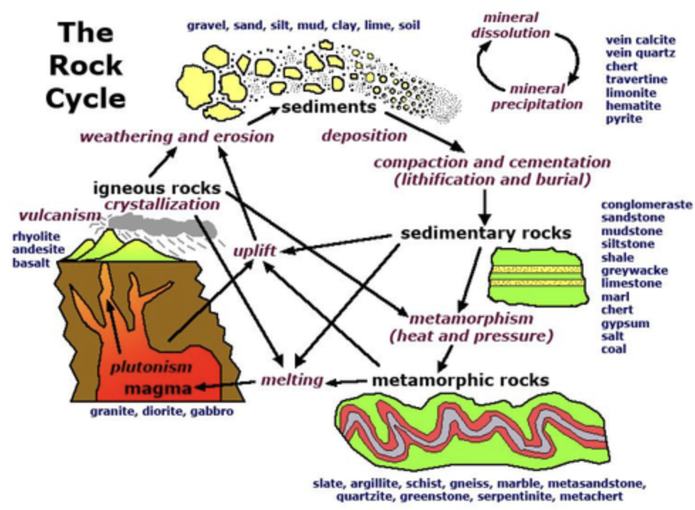
what is the rock cycle?
The rock cycle is a series of processes that create and transform the types of rocks in Earth's crust.
define geology
the science that deals with the earth’s physical structure and substance, its history, and the processes that act on it.
define geomorphology
the study of the physical features of the surface of the earth and their relation to its geographic structures.
define rock structure
the way that rocks are disposed or geologically arranged e.g. jointing, bedding, faulting and permeability.
define lithology
the general physical and chemical characteristics of a rock or the rocks in a particular area) the make-up of each individual rock type.
what are rocks made from?
made of grains that fit together, each grain is made from a mineral ( a chemical compound)
some types of rock have interlocking grains that fit tightly together e.g. granite
some have rounded grains e.g. sandstone
what processes occur at the surface of the earth?
weathering, transportation, and deposition
biological processes
- growth of some of the animals and their shells or skeletons, forming parts of sedimentary rock
what processes occur inside the earth?
burial and subsidence, which may lead to metamorphism as pressure and heat builds up, and then potentially to melting and the first step forming the next igneous rock
why is the age of sedimentary rocks important?
geologically younger rocks tend to be weaker/less resistant.
what are the four different rock types?
igneous
metamorphic
sedimentary
unconsolidated material
features of igneous rocks
how quickly are they to erode?
permeability?
how are they made?
examples
made of cooled magma
are crystalline- which means the interlocking crystals make for strong, hard erosion-resistant rock. - they are resistant because they often have few joints so there are limited points of weakness that erosion can exploit.
IMPERMEABLE
granite, basalt, dolerite, andesite
The average rate of erosion of igneous rocks is 0.1-0.5 cm per year.
features of metamorphic rocks
how quickly are they to erode?
how are they made?
permeability?
examples
what is foliation?
Metamorphic rocks, such as slate and marble, are formed from the change in the structure of sedimentary and igneous rocks, caused by variations in heat and pressure. This intense heat and pressure makes them more resistant.
The process of change is referred to as the rocks having been metamorphosed.
Marble is an example of a metamorphic rock that has been formed from the changing structure of limestone caused by the re-crystallisation of calcite.
Metamorphic rocks are resistant to erosion.
many metamorphic rocks exhibit a feature called foliation- crystals are all orientated in one direction- this can produce weaknesses.
metamorphic rocks are often folded and heavily fractured- these points of weaknesses can be exploited by erosion.
marble, schist, slate, gneiss
features of sedimentary rocks
how quickly are they to erode?
how are they made?
permeability?
examples
Sedimentary rocks, such as Limestone and Sandstone, form from the build-up, compacting and hardening of sediments into layers over time by lithification. They are formed in strata.
Sedimentary rocks that have been formed in a shorter geological time scale tend to be more susceptible to erosion and weathering and erode at a faster rate compared with those formed over a longer geological time.
E.g. limestone and chalk, sandstone, shale
The average rate of erosion of sedimentary rocks is 2-6 cm per year.
PERMEABLE if joined
shale is fine grained and compacted making it impermeable
most sedimentary rocks are clastic (made of different bits of rock) so erode faster.
some have air spaces making them porous.
unconsolidated materials
what are they?
examples
permeability?
example of where they are found in the uk?
how prone to erosion?
sediments deposited by coastal and glacial processes
these materials include (in order of increasing grain size)- clay, silt, sand, gravel
they are loose and not cemented together in any way
easily eroded
some are permeable, some are porous
e.g. boulder clay, gravels, sands - along the Holderness coastline
define strata
(layers, bedding, deposition structures) refer to the different layers of rocks within an area and how they relate to each other.
The term rock strata refers to layers of sedimentary rock. These horizontal layers form from the processes of weathering, erosion, deposition, compaction, and cementation. This process forms layers where newer layers are deposited and formed on top of older layers, allowing for the relative dating of each layer.
define bedding planes
(horizontal cracks) these are natural breaks in the strata, caused by gaps in time during periods of rock formation.
define joints + examples
(vertical cracks) these are fractures, caused either by contraction as sediments dry out, or by earth movements during uplift.
Joints are fractures in rocks created without displacement.
They occur in most rocks, often in regular patterns, dividing rock strata up into blocks with a regular shape.
In igneous rocks, cooling joints form when magma contracts as it looses heat.
In sedimentary rocks, joints form when rock is subject to compression or stretching by tectonic forces or weight of overlying rock.
When overlying rock is removed, underlying strata expand and stretch, creating unloading joints parallel to the surface.
Jointing increases erosion rates by creating fissures which marine erosion processes such as hydraulic action can exploit.
Stair Hole (a small cove adjacent to Lulworth cove)
Purbeck Limestone is intensely folded, known as the Lulworth Crumple. The folding created heavy jointing making the Purbeck Limestone erode much more rapidly that the adjacent Portland Limestone.
Bantry Bay
Carboniferous Limestone is heavily jointed, leading to more rapid fluvial and marine erosion than in adjacent sandstones, contributing to the formation of headland and bay coastal morphology.
define folds + give an example
formed by pressure during tectonic activity, which makes rock buckle and crumple. e.g. the Lulworth crumple
Folds are bends in rocks. They are produced by sedimentary rock layers being squeezed by tectonic forces. The two main types are anticlines and synclines. An anticline is an uphold and a syncline is a downfold. You can get these folds as symmetrical, asymmetrical our overturned.
Folded rock is often more heavily fissured and jointed, meaning they are more easily eroded.
It also increases erosion rates by increasing angle of dip, and by causing joint formation as rock is stretched along anticline crests and compressed in syncline troughs.
define faults
formed when the stress or pressure to which a rock is subjected, exceeds its internal strength (causing it to fracture). The fault then slips or moves along fault planes.
what is a fault plane?
A fault plane is the plane that represents the fracture surface of a fault. A fault trace or fault line is a place where the fault can be seen or mapped on the surface. A fault trace is also the line commonly plotted on geologic maps to represent a fault.
define a dip
this refers to the angle at which rock strata lie (horizontally, vertically dipping towards the sea, or dipping inland)
what is consolidated material/sediment?
"Consolidated sediment" is essentially solid rock made from materials that have been metamorphosed or cemented together. For example, limestone is made of oceanic deposits of billions of shells; likewise, sandstone is made of tiny grains of sand.
Groundwater flows through fracture networks and/or pore space in these consolidated sediments. Consolidated sediments are sedimentary rocks, including conglomerate, sandstone, siltstone, shale, limestone, and coal.
Why are some rocks weaker than others? How does this affect cliffs? How is geology an important factor affecting rates of coastal recession?
some rock types, such as clay, have a weak lithology, with little resistance to erosion, weathering and mass movements. This is because the bonds between the particles that make up the rock are quite weak.
others such as basalt, made of dense interlocking crystals, are highly resistant and are more likely to form prominent coastal features such as cliffs and headlands.
others such as chalk and carboniferous limestone are soluble in weak acids and thus vulnerable to the chemical weathering process of carbonation.
define cliff profile
cliff profile: the height and angle of a cliff face, plus its features such as wave-cut notches or changes in slope angle.
Coastal recession rates of different rock types stats
- igneous eg granite ~ 0.1cm per year
- metamorphic ~ 0.1-0.3 per year
- sedimentary eg limestone ~ 1cm per year
- sedimentary eg young sandstones ~ 10cm per year
-unconsolidated sediment eg boulder clay at Holderness coast ~ 2-10m per year
How can rock structure create a desirable quality?
in porous rocks like chalk- tiny air spaces separate the mineral particles.
the pores can absorb and store water- a property known as primary permeability.
Chalk is the major aquifer of southern and eastern England. It is a microporous white limestone with low matrix permeability. It is an aquifer due to its well-developed interconnected network of fractures.
What causes anticlines and synclines?
Anticlines and synclines are caused when tectonic plates move together and compress the earth's crust between them. Having nowhere else to go, the crust rises into folds much like a rug would if the ends were pushed together.
an anticline is-
A fold in rock that bends upward into an arch
a syncline is-
A fold in rock that bends downward to form a valley
Expansion at anticline, compression at a syncline
Expansion at the anticline widens the joints, exposing them to more weathering and erosion - compression/contraction in the syncline can cause rock disintegration
As it overturns, the axis line turns in a fracture/fault line
This long fault line allows weathering and erosion to penetrate deep into the rock
In geology - what is a bed?
the smallest division of a geologic formation or stratigraphic rock series marked by well-defined divisional planes (bedding planes) separating it from layers (strata) above and below.
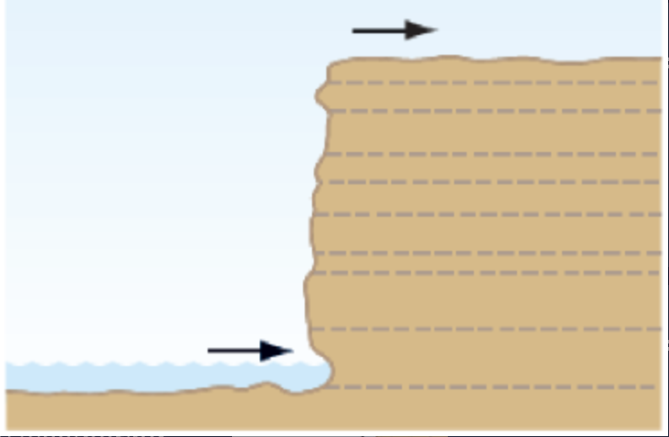
Describe the structural identity of landward dipping strata
rocks loosened by weathering and wave action are difficult to dislodge; the slope profile is gradually lowered by weathering and mass movement.
steep profile
very stable
Describe the structural identity of seaward dipping strata
undercutting by wave-action removes basal support; rock layers loosened by weathering slide into the sea along the bedding planes
rock layers weakly bonded + readily loosened by weathering
Describe the structural identity of horizontally bedded strata
Vertical/near vertical profile - undercutting by wave action leads to rockfall - cliff retreats inland, parallel to the coast.
how do igneous rocks have an interlocking texture? (grains)
- As igneous rocks begin to cool down from the molten state, the grains are crystals which grow together to form an interlocking texture, with the crystals touching each other.
how are crystals in metamorphic rocks formed?
- grains in metamorphic rocks are made up of crystals
- they are usually formed under pressure,
-the crystals are often aligned in one direction and form bands of different colours or shapes of crystal.
how are sedimentary rock crystals formed?
- As sedimentary rocks are formed of bits of other things stuck together, they have individual grains (called 'clasts' in sedimentary rocks therefore they can be described as clastic!) cemented together.
the 3 types of cliff profiles/stratas?
landward dipping
horizontally bedded
seaward dipping
what is deformation?
the degree to which rock units have been tilted or folded by tectonic activity.
What is a cliff?
a vertical, near-vertical or sloping wall of rock or sediment that borders the sea
what are five factors that might interact to influence cliff morphology?
geology
sub-aerial processes
marine processes/erosion
meteorological events
human intervention
what are composite cliffs?
cliffs made up of more than one rock type.
how does difference in resistance of rock in strata affect erosion of cliffs?
if less resistant, weak rock is at the base of the cliff, undercutting and therefore collapse may occur- if at the top then it is subject to sub-aerial processes
more resistant rock is less susceptible to erosion e.g. granite
What impact may permeability have on cliff profiles? (geology) what does a buildup of water create?
cliffs which have impermeable rock overlying permeable rocks limit percolation and therefore are more stable, preventing mass movement.
whereas, in cliffs which permeable rock is on top- water can percolate into and saturate the cliff, making destabilisation and slope failure more likely as water builds up between the junction of the two rocks.
water accumulates in the permeable layer, producing a saturated layer where the pores are full of water.
A spring will form on the cliff face at the top of the saturated layer.
As the stream flows down the cliff, fluvial erosion (surface run off erosion( will attack the saturated permeable bed and lower impermeable stratum, reducing the angle of the cliff profile.
What is a concordant coastline? + example
Concordant coasts usually form where rock strata or folds run parallel to the coast. Therefore there is usually one of rock/ rock resistance along the coastline.
Some concordant coasts have long, narrow islands running parallel to the coastline.
Concordant coasts are also known as Dalmatian coasts, after the Dalmatian region of Croatia, or Pacific coasts, after the coastline of Chile in South America.
What is a discordant coastline? + example
These are where rock strata or structures are aligned at a 90 degree angle to the coastline. The rocks outcrop
Discordant coasts have a crenellated pattern of projecting headlands and indented bays.
Discordant coasts are also known as Atlantic coasts, after the Cork coastline in the Republic of Ireland.
What is differential erosion?
The altering rate of erosion of hard and soft rock
Dalmatian Coast of Croatia
On the Adriatic Sea
A concordant coastline produced by the geological structure of folds parallel to the coast.
Tectonic forces produced by the collision of African and Eurasian plates compressed Carboniferous Limestone during the Alpine Orogeny 50 million years ago.
Created up folded ridges (anticlines) and down folded valleys (synclines) aligned parallel to the coast.
Sea level rise at the end of the Devensian Glacial overtopped the low points of the anticlines and the sea flooded synclines.
This produces lines of narrow islands parallel to the coast formed by projecting sections of anticlines.
Lines of islands separated by narrow sea channels parallel to the coast (sounds)
Haff Coastlines
These form where deposition produces unconsolidated geological structures parallel to the coastline.
During the Devensian glacial the sea level was about 100 m lower than today as water was retained in huge ice sheets.
Meltwater rivers on land beyond the ice front deposited thick layers of sand and gravels onto outwash plains (sandurs)
In the Holocene Interglacial constructive waves pushed the ride of sands and gravel landwards as sea levels rose.
Sand ridge formed bars across some bays and river mouths, with trapped river water forming a lagoon behind (callled haffs in Poland on the Baltic Sea)
For example the Neman Haff behind the bar running from the Kaliningrad in Russia to the Lithuanian coast at the mouth of the river Neman.
Chesil Beach in Dorset was formed this way. Shingle ridge reconnected island of Portland Bill to land (a tombolo)
How are headlands and bays formed?
Rock strata that are less resistant (due to the rock unit's lithology and structure) erode rapidly to form indented bays.
More resistant strata erode only slowly and are left projecting into the sea as headlands.
The relative resistance of rock types influences the degree of indentation of bays.
Headlands and bays are coastal landforms that are formed as a result of erosion caused by waves. Headlands are rocky outcroppings of land that extend out into the sea, while bays are inlets of water that are surrounded by land on three sides.
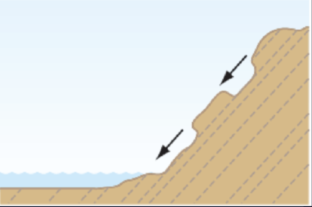
What are micro features? what causes/ creates them?
Micro-features are small-scale coastal features such as caves and wave-cut notches which form part of a cliff profile. They form in areas weakened by heavy jointing, which have faster rates of erosion, enlarging the joint to form a sea cave. e.g. along the Glamorgan Heritage Coast
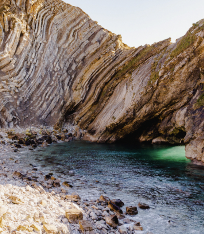
How was the stair hole formed?
From the seaward side, Stair Hole appears as a series of caves and arches in the resistant Portland Limestone. These have formed as cracks and joints in the limestone have been exploited and widened by marine erosion processes.
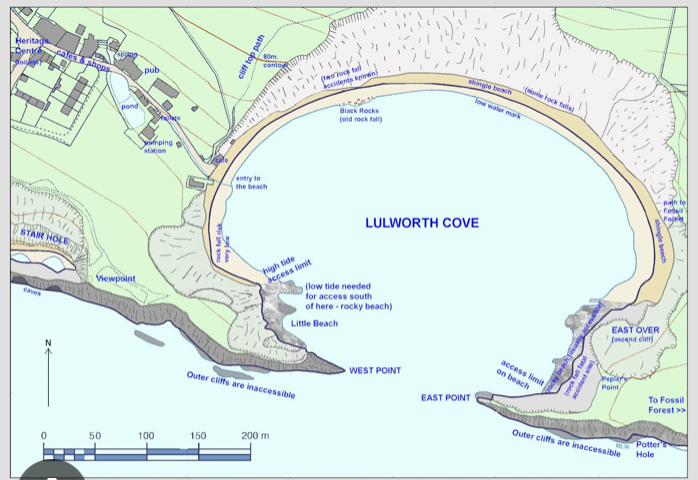
How was lulworth cove formed?
The distinctive Clam or horseshoe-shaped cove formed roughly 10,000 years ago by the power of the sea due to wave diffraction. The narrow cove entrance (between the resistant pillars of Portland limestone) caused waves to bend in an arc shape around the rocks.
wave refraction vs diffraction?
Refraction occurs when wave swells approach the beach at an angle. Diffraction involves the dispersion of wave energy. Wave diffraction refers to various phenomena which occur when a wave encounters an obstacle or change in the geometry of the seabed.
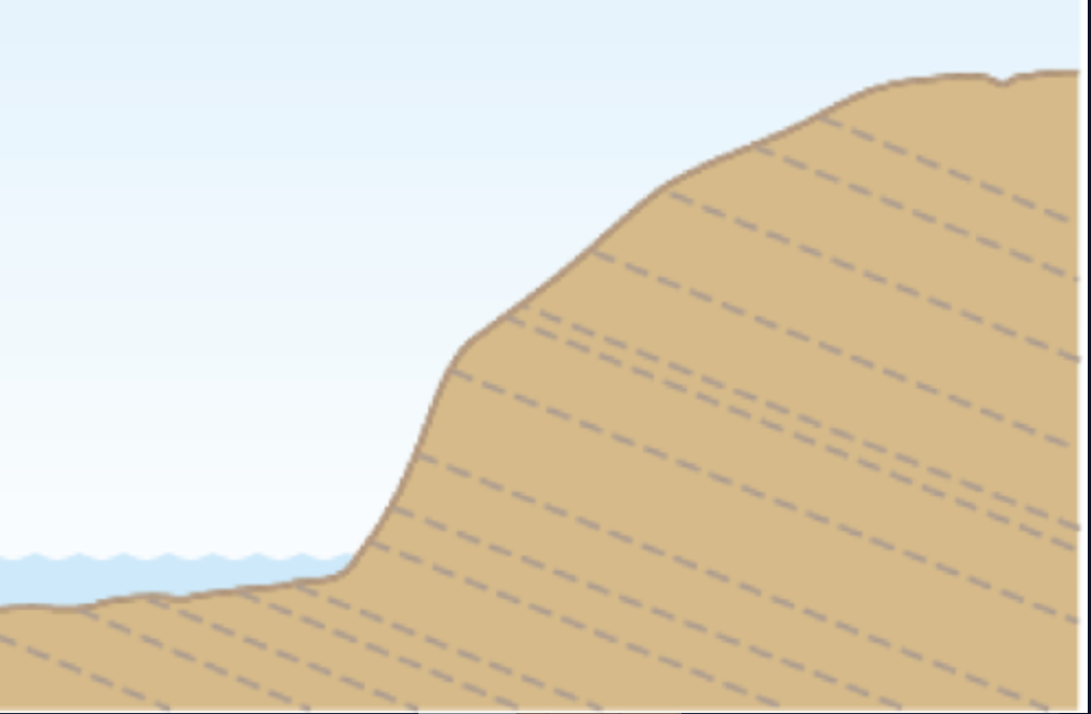
what is beach morphology?
the shape of the beach
what is a beach sediment profile?
the pattern of distribution of different sized or shaped deposited material.
profile created by net movement up the beach is?
steep gradient
profile created by net movement down the beach is?
gentle gradient
How do shingle beaches impact a beach profile? x 5
larger particles
have higher percolation rates, allowing water to pass through more rapidly
reduced surface backwash
reduced shingle moved back down the beach & larger sediment left as ridge or berm
steeper beaches
Swanage Bay
on the Isle of Purbeck in East Dorset
formed by the erosion of less resistant Wealden Clays
More resistant Jurassic Portland Limestone forms the Peveril Point headland to the south, projecting out by 1 km.
Resistant Cretaceous Chalk forms the Foreland headland, projecting 2.5 km to the north.
structure not the only factor influencing the indentation of Swanage Bay, Swanage bay faces east so is sheltered from the prevailing south westerly wind and highest energy waves.
How does mineral composition affect resistance?
Some rocks contain reactive minerals easily broken down by chemical weathering, e.g. calcite in limestone.
Other minerals are more inert that chemically weather more slowly, if at all, e.g. quartz in sandstone.
what is pore water pressure?
the internal force within cliffs exerted by a mass of groundwater within permeable rocks
Pore water pressure in the saturated layer pushes rock particles apart.
Reduces friction between grains in unconsolidated material
Lubricates lines of weakness, e.g. joints and bedding planes.
This affects a cliff’s stability.
The larger the size of the shingle the…
…steeper the gradient of the beach.
What effects do sand beaches have on a beach sediment profile x 7
small particle size
becomes compact when wet- severely restricts percolation
lots of surface backwash
material carried down the beach and deposited in an offshore bar
waves break further from the shore
wider beach allowed to develop
more gentle gradient beaches
beach profiles- decadal variation x 3
climate change will cause more extreme weather events
events alike usually occur in winter (storms) so the winter profile may be there for longer.
beach size reduced by more frequent destructive waves- coastal erosion increased because tides will be able to reach the back shore.
beach profiles- seasonal variation in the UK x 2
Winter
destructive waves dominate
spread shingle
offshore ridges/bars form
Summer
stronger swash (constructive waves)
sediment builds up beach
steepens beach angle?
particles sorted by size
berm ridges formed
beach profiles- monthly variation x 5
tide height varies over the month due to the moon
twice a month - spring tide - highest high tide
two very low high tide (neap tides)
lower tides will produce berms
berm destroyed once neap tide passes
beach profiles- daily variation x 4
Storm events in summer - destructive waves - reshape beach profile in a few hours. Some material may be thrown up above the high-water mark by very large waves
Calm anticyclonic conditions in winter can produce constructive waves- rebuild the beach, steepening the profile for a few days before a storm.
Destructive waves change to constructive ones as the wind drops.
Storm beaches, - back of the beach, the high energy deposition of coarse sediment during severe storms.
Berms
where in the littoral zone and why
formation and characteristics
temporal characteristics
Berms are formed by constructive waves during calm weather, where material is added to the beach. Storms and spring tides can move existing berms up the beach, meaning that a new berm can develop, which changes the beach profile.
can be removed by the next high tide - remain if subsequent high tides don't reach
storm beach
where in the littoral zone and why
formation and characteristics
temporal characteristics
A storm beach may form when wild, stormy weather and waves hurl boulders and large pebbles to the back of a beach.
- accumulate over years
offshore bar
where in the littoral zone and why
formation and characteristics
temporal characteristics
Offshore bars are ridges of sand or shingle running parallel to the coast in an offshore zone. They form from sediment eroded by destructive waves and carried seawards by backwash.
- temporary
- constructive waves push material from bar up to the beach.