8) Volcanic Hazards
1/37
There's no tags or description
Looks like no tags are added yet.
Name | Mastery | Learn | Test | Matching | Spaced |
|---|
No study sessions yet.
38 Terms
Planning for eruptions
warnings of immanent eruptions can be issued to governments by civil authorities
- contingency plans in place, involving hazard maps to identify areas most at risk in the "red zones", safe zones and evacuation zones created
- mitigatory changes to prevent or lessen impacts e.g., earth embankments to divert lava flows from property
Volcanic Hazards
pyroclastic flows, lahar, lava flows, ash fall, gas/acid rain, tephra
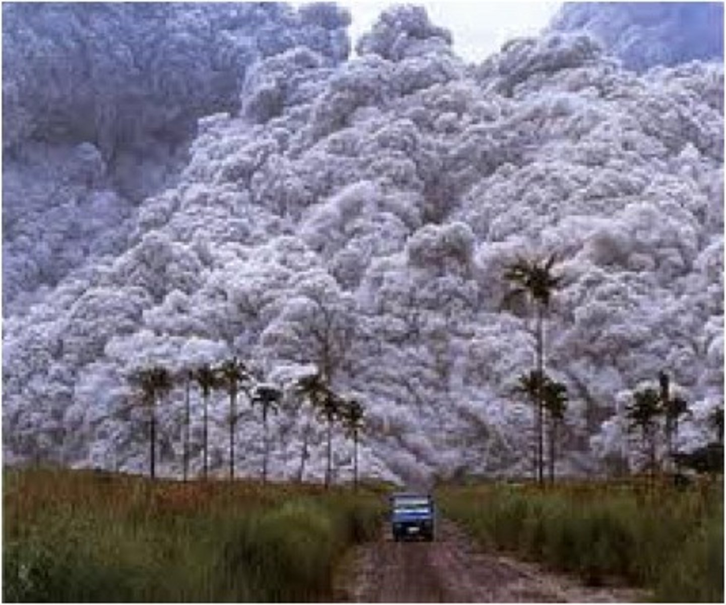
Pyroclastic flow
"burning cloud"
typically forms due to rising lava reacting with cold air to form microscopic particles of volcanic glass (obsidian/ash)
- process = known as "doming" as obsidian rises out of volcano and fragments accumulate to form a dome
- becomes so big the dome collapses and forms pyroclastic flow
- around 600 degrees c, deadliest hazard, only lasts a few hours, travels no more than 10km but at a speed of 600km/h
Lava flows
typically slow moving, later on in the eruption
Lahars
mudflows
volcanoes = mountains with snow + ice, which melts when erupts within minutes, water then pours off the side of mountain and mixes with the ash to create a mixture of mudflow
- moves very fast and travels far distances
- heavy tropical rain has the same effect
caused by...
- rapid melting of ice/snow on slopes
- pyroclastic flows entering streams
- eruption induced heavy rainfall
- eruptions ejecting water directly from a crater lake
Ash fallout
obsidian shatters into tiny pieces
- can be inhaled + cause respiratory problems
- ash flies into stratosphere
- ash = very reflective, reflects incoming UV rays, which leads to global dimming and possibly a volcanic winter
- clogs engines of aircrafts
- can last days, travel over 100km, disrupt global supply chains + climate
Gases/acid rain
gases released dissolve in atmospheric H20
- SO2 goes to sulfuric acid
- NO2 goes to nitric acid
- CO2 goes to carbonic acid
- affects soil pH so trees/plants die
- affects pH levels in water sources, marine organisms die as a result
- destroys natural habitats
steam is released during eruption, may contain nuclei of sulphur, heat from eruption encourages convection currents to rise, steam condenses above volcano into localised clouds, results in bursts of sulphuric acid rain
Tephra
large fragments of rock ejected into the air by an erupting volcano
- slowly builds up into composite/strato-volcanoes
Acid dome volcano
Steep-sided convex cones of thick, viscous lava (silica-rich gaseous lava that solidifies before travelling very far)
- associated with destructive plate margins, explosive eruptions of pyroclastic flow
e.g., mount Pelee, 1902, Caribbean Island Martinique, worst volcanic disaster of 20th century, pyroclastic flow killed 30,000 people minutes after erupting
Frequency and regularity of volcanoes
eruptions are rarely, if ever, measurable to any degree of predictable accuracy
- many volcanoes are dormant rather than extinct (e.g, mount st helens + chances peak)
- volcanologists have to rely on average cycles of activity to alert necessary observations for eruptions
- higher frequency = more effusive, recurrence interval concept
e.g., mount Vesuvius, 70 year cycle, last erupted in 1944, long overdue for eruption, current contingency plan =
- 3 million people within 15km of base will receive 2 weeks warning, week long emergency evacuation of 600,000 people from "red zone" identified at greatest risk from pyroclastic flow
Monitoring volcanoes
monitoring to detect signs of change that forewarn of volcanic reawakening, tend to follow weeks of seismic activity + warning signs
- equipment = very reliable
seismometres, laser based electronic distance measuring, tiltometers, magnetometers, hydrological instruments, thermal imaging, remote solar powered digital camera
Seismic activity
measured using seismometers and recorded on seismographs
detects micro quakes which indicate rising magma, fracturing and cracking overlaying rocks within volcano
Ground deformation
measured using tiltometres and laser based electronic distance measurements
- bulging (inflation) of the ground is caused by rising magma
- both the slope angles and increasing distance between two points can be measured very accurately
movement of rising magma (magnetometers)
changing magnetism within volcano is common geophysical indication of rising magma, before the eruption it rises to the surface which deflates the magma chamber
rising groundwater temperature/gas content
measured using hydrological instruments
- rising magma will both heat the groundwater and corrupt it with gases such as sulphur, which increases its acidity
warning signs of eruptions + remote sensing
e.g., small eruptions, steam rising from central vent, emissions of gases, landslides or rockfalls from faults (magma rising)
- recorded using remote sensing equipment
- remote solar powered digital camera surveillances to record physical changes in and around the main crater (powerful + safe)
- thermal imaging and gas sampling of poisonous emissions (e.g., chlorine)
Icelandic volcanoes
gently flowing lava from a central vent or fissure (linear vent)
- gentle and consistent eruptions
Shield volcanoes
- normally at constructive plates
- basaltic lava
e.g., Heimey, Iceland
hawaiian volcanoes
lava is gently emitted from a central vent, gentle eruptions and is predictable
Shield volcanoes
- often formed from hotspots
- basaltic lava
e.g., Mauna Loa, Hawaii
last eruption in Hawaii = september 2023
Strombolian volcanoes
small but frequent and explosive eruptions of tephra and steam
Stratovolcano
- thicker basaltic lava
- short and only occasional lava flows
e.g., Paricutin, Mexico
vulcanian volcanoes
short, violent, relatively small explosion of gases, ash and tephra
Stratovolcano
- thicker, andesitic lava with viscous magma
e.g., Italian island of Vulcano
Vesuvian Volcano
violent explosion after a long period of inactivity/dormancy
- unpredictable
- very violent gas explosions
Stratovolcano
- thicker basaltic, andesitic and rhyolitic lava
e.g., Vesuvius, Italy
Krakotoan volcanoes
Exceptionally violent eruption which may remove much of original cone shape to collapse and form a caldera
- unpredictable
- andesitic lava
e.g., Krakatoa, Indonesia
Pelean Volcanoes
violent eruptions accompanied by large pyroclastic flow
- andesitic and rhyolitic lava
e.g., Mount Pelee, Martinique
Plinian volcanoes
very powerful, continuous eruptions of gas, ash and pumice
- very violent
- torrential rainstorms may cause devastating lahars due to large amount of material ejected
Stratovolcanoes
- lots of lava + pyroclastic material ejected
- rhyolitic lava
e.g., Mount Pinatubo, Philippines
shield volcanoes
- liquid/fluid lava emitted from the central vent, large vents may collapse to form calderas
- usually found at constructive margins (basaltic lava) or over hotspots
- formed by frequent, gentle eruptions of thin, fluid lava (low viscosity) which will flow a long way before solidifying
- less explosive gas so less ash released, gentle eruptions
- gentle sloping slides
e.g., hawaiian + Icelandic volcanoes
composite cone/stratovolcanoes
composed of different materials, has alternating layers of lava and ash (other volcanoes = just ash)
- usually found at destructive + compression plate boundaries (andesitic lava)
- more viscous lava which erupts from central vent
- lateral/secondary vents form if the central vent becomes blocked from the rising lava solidifying, which may lead to a massive explosion in the central vent or lava escaping through side vents
- any fragments of rock are shattered from the initial explosion so lots of ash is emitted, but becomes trapped in alternating layers by the rising lava cooling
Fissure volcanoes
a linear (long line) volcanic vent which lava erupts from, usually without any explosive activity
- gentle slopes made of basaltic lava
- the fissure (vent) is usually only a few m wide but is many km long
- magma = high temperature, low gas content
Dome volcanoes
roughly circular mound dome, relatively small but can be very explosive
- commonly occur adjacent to craters or composite volcanoes
- central vents with steep convex slopes from thick, fats-cooling (viscous) lava
basaltic to rhyolitic magma, with high silica content
- lava = so viscous it forms a "blob" which usually blocks the central vent until it erupts through explosive action
may form a caldera if central vent collapses
Ash-cinder volcanoes
- steep, conical hill that consist of glassy volcanic fragments
- fragments are emitted from the central vent with cinder and fine ash making up the slopes
- explosive liquid/fluid lava
- small but can be built up to form composite volcanoes after continuous eruptions
Flood/Plateau basalt
very liquid/fluid lava
- flows very widespread
- emitted from fractures
Caldera volcano
- very large composite volcano that has collapsed after an explosive period to form a crater
- after large explosion, blocked central vent may collapse to form
- frequently associated with plug domes
e.g., yellowstone
- krakotoan = caldera volcano
- could form a super volcano if the volcano collapses in the centre vent to form a huge magma chamber, very explosive eruption
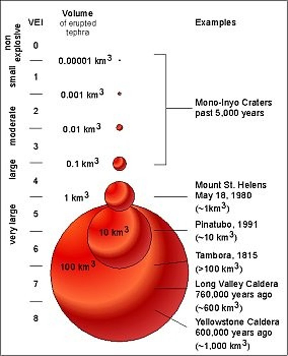
Volcanic Explosively Index (VEI)
measures the size/magnitude of a volcanic eruption in terms of amount of ash produced (volume of tephra)
Ranges from 8-0
- 8 = extremely large
- 0 = non-explosive
uses a logarithmic scale with each number increasing by a factor of 10
VEI uses several factors to assign a number, including:
a. the amount and height of volcanic material ejected
b. how long the eruption lasts
c. qualitative descriptive terms e.g., gentle or explosive
Super volcanoes
volcanoes that have very large and explosive eruptions
e.g., Yellowstone national park
(potential to cause continental damage)
effects of super volcanoes
- over 100,000 people could be killed instantly from pyroclastic flow and the initial explosion
- 25-mile high ash-cloud
- dark summer, ash in the upper atmosphere will circulate around the globe, no sunlight for at least a year
- massive lahars, 25 mile high ash cloud disrupting food supplies around the globe (mass starvation)
-ecosystems destroyed, crops devastated from ash, animals die due to respiratory problems + starvation, acid rain
- homes destroyed, air/road/rail travel disrupted, water supplies contaminated
- global temps drop by 3-5°c and remain low for many years, global ice age triggered (little life can survive)
Spatial distribution of volcanoes
volcanoes normally follow...
- constructive and destructive margins, are absent at conservative plate margins (no magma)
and
- sometimes occur at hotspots in the centre of plates (pacific ring of fire)
or
- along rift valleys (great African rift valley)
basaltic lava=constructive plate margins
rhyolitic/andesitic lava= destructive plate margins
Magnitude of volcanoes
uses a logarithmic scale from 0-8 called the Volcano explosivity index
(VEI)
1 = gentle, 4 = cataclysmic, 8 = mega-colossal
- measures amount of tephra ejected
- measures duration of eruption
- measures height of material ejected
- measures explosiveness
super volcano Yellowstone National Park may exceed 8 if it erupts again
calmer eruptions + lower magnitude = effusive
intense + high magnitude = explosive
Recurrence intervals
the belief that the bigger something is, the less often it occurs
Predicting volcanoes
history pattern of activity
- uses the eruption recurrence interval data to predict and figure out statistics of how often a volcano erupts and the size of an eruption
- can study deposits from around the volcano to determine age, type, size and distance lava travelled from volcano
- can create a volcanic hazards map to view areas at greatest risk
- can be aided by evidence from previous eruptions (lahar or pyroclastic deposits studied)