1) Hazards
1/69
There's no tags or description
Looks like no tags are added yet.
Name | Mastery | Learn | Test | Matching | Spaced |
|---|
No study sessions yet.
70 Terms
Hazard
"A perceived natural event that has the potential to threaten both life and property" (Whittow)
The threat of substantial loss of life, substantial impact upon life or damage to property that can be caused by an event
Human Hazards
occur due to human activity
- explosions, chemical releases, nuclear incidents
Natural Hazards
natural events in the physical environment
- volcanic eruptions, tsunamis, earthquakes, storms
Human influences on natural hazards
e.g., wildfires, caused by human carelessness
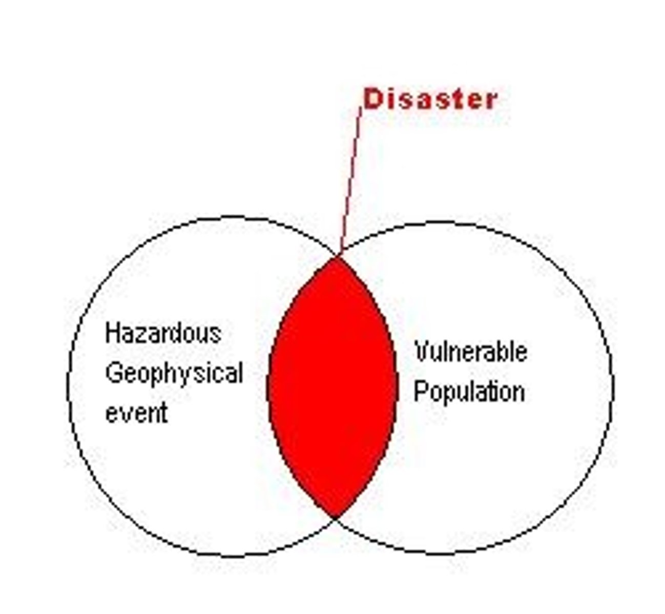
Disaster
occurs as the result of a hazard...
"when it causes a significant impact on vulnerable population" - Degg
e.g., hazard = living on a fault line
disaster = earthquake the occurs on that fault line + has significant impacts
Why are more people being affected by natural hazards
population is increasing, particularly in high risk areas so more people are affected
- the expansion of urban areas in high risk areas means more property is likely to be destroyed
"Loss of property from natural hazards is rising in most regions of the earth, and loss of life is continuing or increasing among many of the poor nations of this world"
- Burton, Kates, and Whites, 1978
potential impacts on natural hazards
dependent on magnitude, location, plate boundary, etc.
Geophysical, Atmospheric, Hydrological
Geophysical hazards
driven by the earth's own internal energy sources
- seismic activity, plate tectonics, volcanoes
Atmospheric hazards
driven by processes at work in the atmosphere
- storms, droughts
Hydrological hazards
driven by large bodies of water, mainly oceans
- floods, tsunamis, storm surges
Biological hazards
can cause significant impacts to the health and wellbeing of a community
- disease, insects, animals
Hydrometeorological hazards
natural hazards causes by large bodies of water and processes at work in the atmosphere
e.g., flooding due to excessive rainfall
primary impacts
Immediate effects that happen during or just after the event
(destruction of infrastructure, loss of life)
secondary impacts
Effects that take place a while after the event has taken place
(disease, contamination of water supplies, economic recession)
significant impact
10 or more people killed
and/or
100 or more people affected
(according to CRED)
risk depends on...
1. magnitude of hazard/event
2. the vulnerability of a population
3. the capacity of a society to cope
Degg's disaster model
shows how a hazard only becomes a disaster when the event significantly impacts a vulnerable population
Risk equation
hazard x vulnerability
---------------------------
capacity to cope
perceiving hazards
determined by the effect it may have on our lives
- weigh out the impacts of the hazard against the advantages of living in a high risk area
e.g., living near a volcano or floodplain, high risk of eruption/flooding but fertile soil makes it worth it for farming
Different perceptions of hazards
can be influenced by age, social class and religious beliefs
determined by impacts it could have on a country and how much it would cost for the country to manage
- long term national and global effects of hazards
e.g., agricultural land flooded, food supplies lost, country suffers from food shortages + economic loss, world suffers from food shortages
- LIC's less likely to be able to cope with impacts of a hazard and unable to rebuild
- more economic, social and environmental damages in LIC's
Human responses to hazards
to reduce risk to life and equity
1. fatalism
2. prediction
3. adaptation
4. mitigation
- global level = coordinating rescue + humanitarian aid
- local level = saving possessions, safeguarding property
Response times to hazard
dependent on the magnitude of the hazard, the original state of the infrastructure and the damage done to it after the event - affects speed of international responses
response times = reduced thanks to ADAM - allows almost immediate access to information about available local supplies, infrastructure and the scale of the disaster
ADAM
Automatic
Data
Analyses
and
Mapping system
Fatalism
the belief that the hazard is inevitable and will cause damage no matter what
- the hazard is part of the ecological system and the natural world (e.g., natural wildfires)
Prediction
= predict and prepare for the hazard to a certain extent (investing time, money, materials into technology)
e.g., remote sensing, increased communications, seismic monitoring
Adaptation
after accepting that the event is inevitable, creating plans and preparing for the event to ensure life can continue as normal after the event occurs
Mitigation
= trying to prevent the event itself or plan for the events to lessen the impacts and the damage done
e.g., diverting lava flows with explosions or earth embankments, widening a river so it won't overflow
Hazard management cycle
manages both pre and post event situations
Preparedness
Response
Recovery
Mitigation
successful hazard management focuses in modifying the hazard, the human vulnerability and the loss
- lessens the economic, social and environmental impacts of a hazard so that things can return normal post event
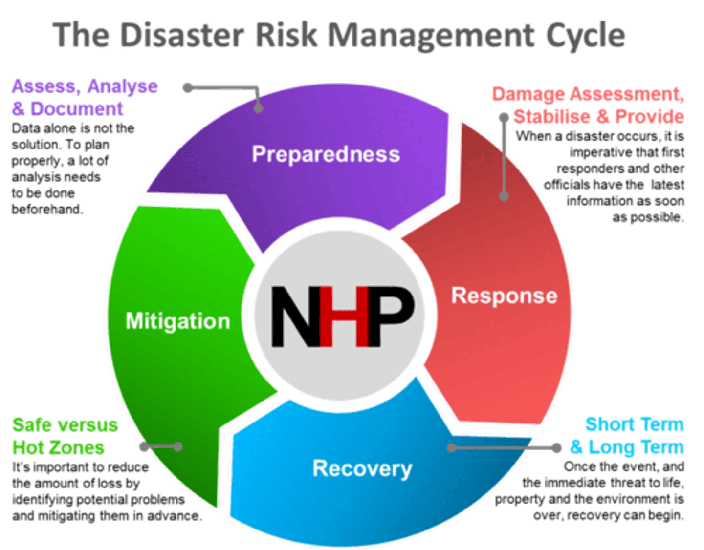
Hazard management cycle: Preparedness
= large scale events are rarely prevented, but education + public awareness can reduce human causes + adjust behaviour to minimise the impacts
- can speed up the recovery process by planning for a quick response in the immediate aftermath
- high risk areas = more prepared
Hazard management cycle: Response
= speed of response depends on the effectiveness of emergency plans in place
= immediate response = focuses on saving lives + coordinating medical assistance
= long term response = focuses on recovery and rebuilding
Hazard management cycle: Recovery
= restoring affected area to something approaching normality
= short term, restoration of services so that longer term planning + reconstruction can begin
Hazard management cycle: Mitigation
= actions aimed to reduce the severity of an event and lessen its impacts
- can involve direct intervention (buildings that can withstand storms/earthquakes) or creating barriers or defensible zones that may slow down or halt the hazard (flood barriers, earth embankments for lava flows)
e.g., long term, protection of natural barriers like coral reefs to protect the shore from storm surges
- support after a disaster = in the form of aid + insurance can reduce long term impacts
(may not be available for some LIC's)
Parks model
a model graph to show the effects of a hazard on quality of life over a sequence of time and expected stages from pre-event to eventual recovery
- may often lead to improvements as quality of life, economic activity and social stability increase
Relief, Rehabilitation, Reconstruction
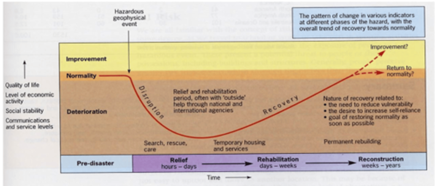
Parks model - relief
the immediate local and possibly global responses in the form of aid, search and rescue and expertise
Parks model - rehabilitation
longer phase, lasting weeks or months, when infrastructure and services are restored to allow the reconstruction phase to begin as quickly as possible
Parks model - Reconstruction
restoring to the same level, or better, quality of life as before the event of occurred
- likely to include measure to mitigate against a similar level of disruption if the event occurs again
Variations to Parks model
Park suggested that any disaster with a very rapid onset (e.g., earthquake) will lead to a faster recovery time and a better quality of life
A slow onset disaster (e.g., drought) would lead to a slower recovery time and deterioration of quality of life
centrifugal force
generated by the earth's rotation, fling the semi molten interior of the earth outwards
- causes the earth to bulge around the equator and flatten around the poles (become geoid)
the structure of the earth
crust, mantle, outer core, inner core
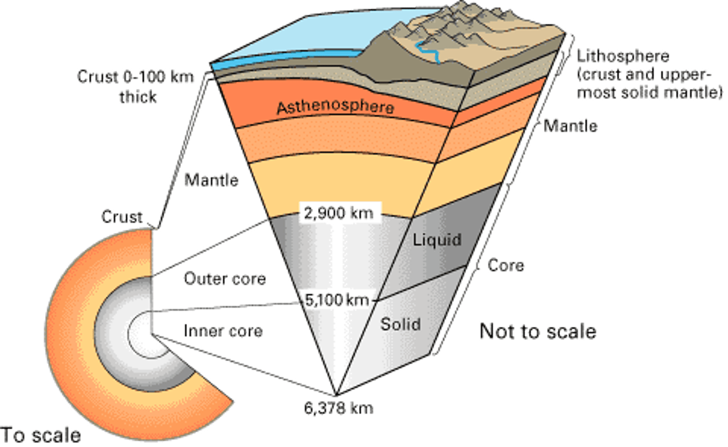
the crust
between 5-10km thick under oceans, up to 70km thick under continents
(thin in relation to the there structures)
oceanic and continental crust
oceanic = broken layer pf basaltic rock known as SIMA (Silicon and Magnesium)
continental = maily granite rock known as SIAL (Silicon and Aluminium)
sial = upper layer of crust, thicker
sima = lower layer, denser
The lithosphere
between the crust and the upper most solid mantle
- where tectonic hazards occur (lithospheric plates)
where the base of the continental crust meets the lithosphere is known as the Mohorovičić discontinuity
Mohorovičić discontinuity
where the base of the continental crust meets the lithosphere
the mantle
thickest layer (2900km), solid + hot, heat softens the mantle so that the interior is hard but can flow slowly (1000 degrees c)
- pressure locks molecules in which makes the mantle rigid at the surface (the mesosphere), here it's hard + strong
- lower pressure allows mantle to flow, ductile zone, low velocity (partially melting rocks, strong rocks below weaker rocks (the asthenosphere)
- cooler + brittle closer to the surface, with rigid rocks (lithosphere)
mesosphere, asthenosphere, lithosphere
the outer core
layer of molten iron and nickel, lower temperature, less pressure pushing the molecules inwards, so the metals melt and the outer core is liquified
- 3700 degrees c
the inner core
a dense sphere of solid iron and nickel, very dense due to compressions and high pressure from the other layers
- 4300 degrees c
continental crust
Sial
Silicon and Aluminium
upper layer of crust, 20-70km thick
primarily granite
oceanic crust
Sima
Silicon and Mangesium
denser, 4-7km thick, will subduct
primarily basalt
Flow of heat from the earths interior to the surface
estimated to be 47 terawatts (TW) and comes from 2 main sources in roughly equal amounts
1. radiogenic heat
2. primordial heat
heat flowing through earth causes large scale convection currents inside the mantle, trigger tectonic activity
76% of heat moves through the mantle, remains 24% is from radiogenic decay in the crust and 99% of heat is lost through conduction in the crust
heat transfer in the earth
1. conduction through the crust
2. convection through the mantle
3. volcanic advection (when liquid heat escapes from a volcano)
Radiogenic heat
produced by radioactive decay of isotopes in the mantle + crust
- radioactive decay of elements in the earths mantle + crust results in the production of daughter isotopes and the release of particle and heat energy
Primordial heat
left over from the formation of the earth
- primordial heat is lost by the earth as it continues to cool from its original formation, whereas the earth still actively produces radiogenic heat
convection cells
why the earth is very tectonically active as lithosphere is continually ripped apart by currents created by the heat moving through the earths interior
Continental drift
Alfred Wegener, 1912, plate tectonic theory
- German meteorologist who proposed the theory that the continents were joined together as Pangea and initially split into two continents which continued to split into smaller continents and oceans
- Geological + Biological evidence
Geological evidence of continental drift
1. rock sequences in the north of Scotland are similar to those found in Canada, suggesting they were once connected
2.evidence of a large carboniferous glaciation in South America, Antarctica and India, cannot be explained by current position
3. Wegener's "continental fit" compared simply to Sir Francis Bacon's Pangea
Biological evidence of continental drift
1. fossil remains of the reptile "lystrosaurus" can be found in Africa, India and Antarctica, no evidence this reptile could swim
2. fossil remains of the same plants found across several continents, the seeds are too heavy for wind borne transportation so must've been dispersed by animals
3. fossils of brachiopods can be found in Indian limestone and are similar to those found in Australia
sea floor spreading
Harry Hess
- Studied the age of rocks on the floor of the Atlantic Ocean, found that the youngest rocks were in the middle and the oldest nearer to the USA and Caribbean
- Newest rocks being formed in Iceland, compelling evidence that the Atlantic's Sea floor was spreading outwards from the centre
- Evidence from studying the earth's magnetic field in rocks, every 400,000 years or so, the earth's magnetic field switches polarity, causing the magnetic north and south poles to swap over - iron oxide in lava erupted onto the ocean floor records the magnetic orientation of that time
- Sea floor spreading from mid ocean ridges (mid Atlantic ridge) can be shown by mirror-imaged patterns of reversals in polarity
why the earth isn't expanding
- Deep ocean trenches provide evidence that for every new plate formed and spread outwards, another plate is destroyed via subduction elsewhere
- This causes seismic, volcanic and fold mountain activity across the world on what are known as fault lines (where most of the world's landforms occur)
- No gaps between plates, for every plate moving apart, new oceanic plate is formed (mid ocean ridges)
convection currents created by...
Radioactive decay within the core generating extreme temperatures which can be concentrated to form hotspots around the core and heat the lower mantle, creating convection currents which rise towards the surface before spreading in the asthenosphere, then cooling and sinking again
Constructive plate margins
divergent plates, separate/move apart
- oceanic, sea floor spreading + mid-ocean ridges
- continental, rift valleys, shield volcanoes
Mid ocean ridges
large chains of submarine mountains = mid-ocean ridges, transform faults cut across ridges, middle of ridge = rift valley
1. two lithospheric plates diverge due to convection currents within the asthenosphere, allows the mantle to rise up and reach the surface, making new crust
2. crust separates and fractures, magma then forces its way through transform fault lines and find a centre of unsupported crust which sinks due to the magma welling up around it
3. leaves an elevated underwater depression known as a rift valley
4. shield/submarine volcanoes are formed roughly parallel to each other on either side of rift, gentle ongoing eruptions occurring as new crust forms
transform fault lines in mid ocean ridges
occur at right angles to the plate boundary and parallel to each other
continental divergences
Thicker crust, rift valleys
- higher tensional frictional forces pulling the plates apart, rift valleys are very large
- have "horsts" at either end, which separate the rift valleys and the crust is very thick here
destructive plate margins
convergent plates, collide
- oceanic plate meets continental
- oceanic plate meets oceanic
- continental plate meets continental
oceanic meets continental (destructive)
Subduction, plates collide due to constant convection currents below melting plates
- continental plate = buoyant, won't sink, oceanic plate = dense and subducts under continental
-- forms a deep ocean trench
shallow, intermediate and deep focus earthquakes created in Benioff zone
e.g., Pacific Coast of South America
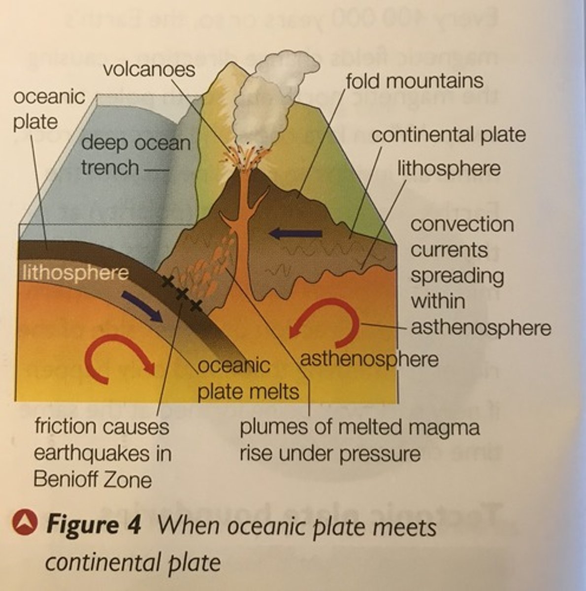
the Benioff zone
the zone where the plates melt
- caused by gravitational/slab pull where the oceanic plate sinks into the asthenosphere and subducts
the melting plates produce magma, which is less dense than the surrounding asthenosphere so rises and passes into faults of continental plates, reaching the surface to form explosive stratovolcanoes
Types of earthquakes in Benioff zone
intermediate + deep earthquakes
= formed by the disintegration of the plate as it descends into the lower mantle, increased heat and friction at depth, which leads to tension
- stresses build up due to tension before being release as earthquakes
oceanic plate meets oceanic plate (destructive)
when two oceanic plates collide, one will always be denser or faster and will subduct under the other
(slab pull causes the plates to sink down and subduct)
- leads to the formation of a deep ocean trench
- melting results in rising magma from the Benioff zone, which forms crescents of submarine volcanoes along the plate margin which may grow to form volcanic arcs
e.g., Mariana Trench and islands in the Western Pacific
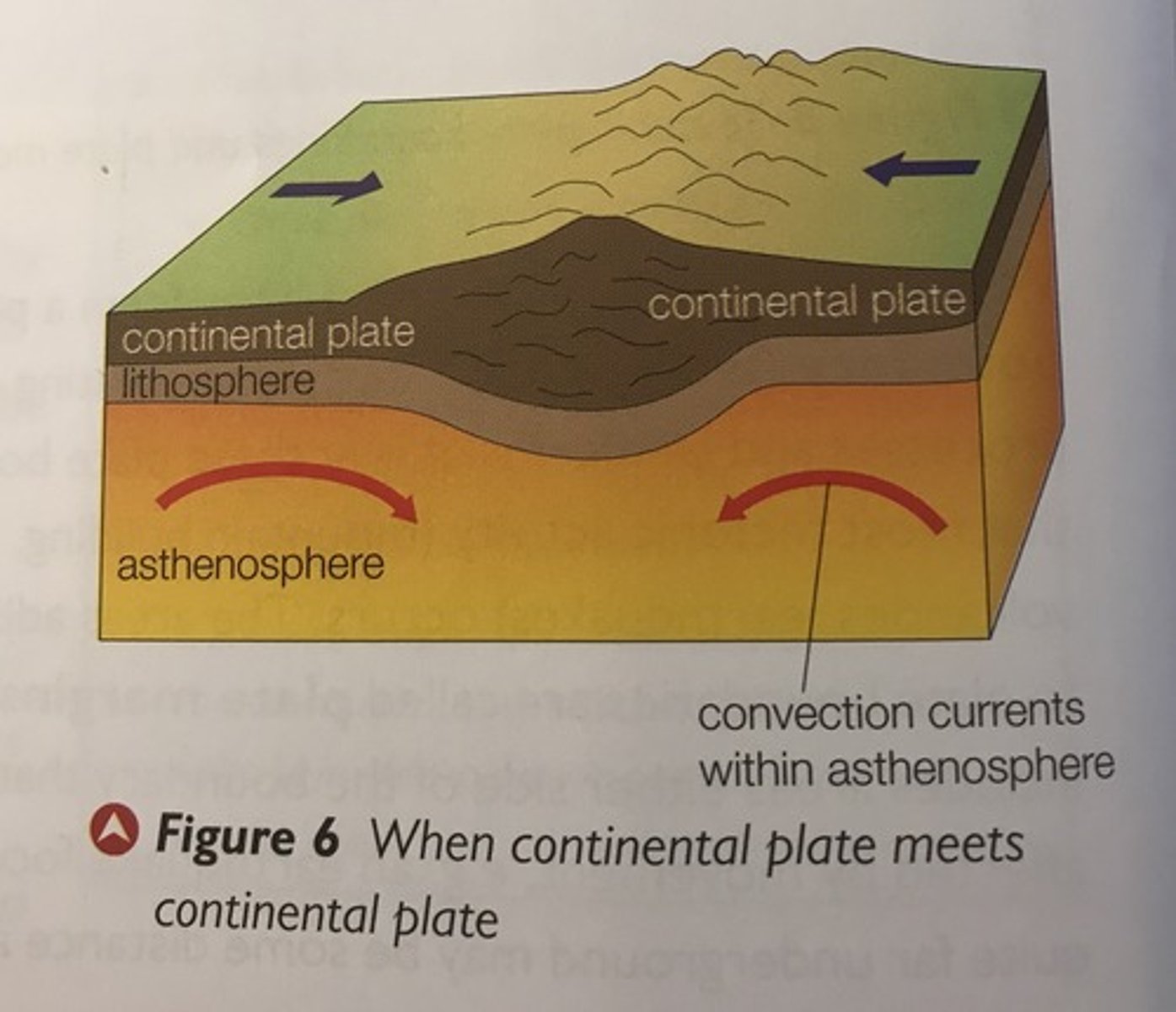
Continental plate meets continental plate
collision plate boundary
- continental plate = less dense than the asthenosphere, will not subduct (no melting, no magma, no volcano)
continental plates collide and uplift each other, then buckles to form fold mountains, continually compressing and growing higher
e.g. the Himalayas
conservative plate boundary
when two plates slide past each other, moving at different rates
friction between two moving plates leads to stresses building up as friction increases, which may eventually be released suddenly as powerful shallow-focus earthquakes
(no subduction, no magma, no volcano)
e.g., San Andreas Fault, San Francisco
Magma plumes
large columns of extremely hot magma rising through the mantle from the outer core - forms hotspots
tectonic activity explained by plates moving, not always at plate boundaries as not controlled by convection cells
radioactive decay in the core generates hot temperatures which can be concentrated to from hotspots
^
- causes localised thermal currents where magma plumes rise
- flood basalts can form (rapid lava flows)
- burns through lithosphere to create volcanic activity on the surface
hotspots = stationary, but plates move resulting in the formation of chains of volcanic islands
e.g., Hawaiian islands in the centre of the pacific plate