Earth Science Lab Quiz 2
1/101
There's no tags or description
Looks like no tags are added yet.
Name | Mastery | Learn | Test | Matching | Spaced | Call with Kai |
|---|
No analytics yet
Send a link to your students to track their progress
102 Terms
Hydrologic Cycle
The continuous, solar-powered movement of water between the Earth's surface, atmosphere, and underground
Runoff
Precipitation that does not soak into the soil but instead moves on the Earth’s surface towards steams
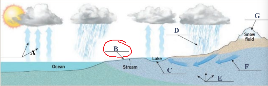
Infiltration
Precipitation that soaks into the soil
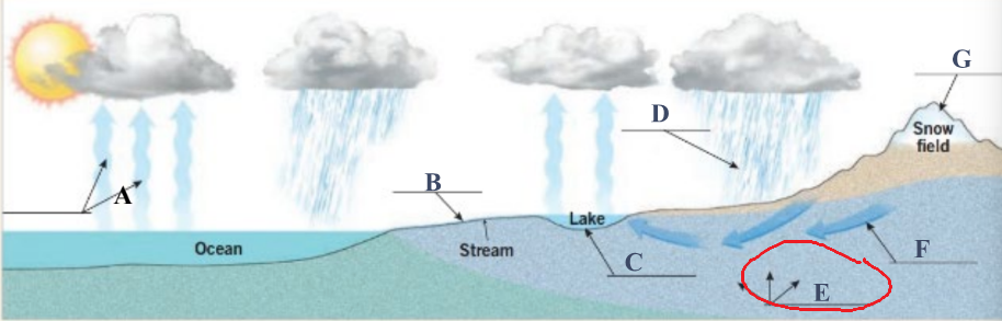
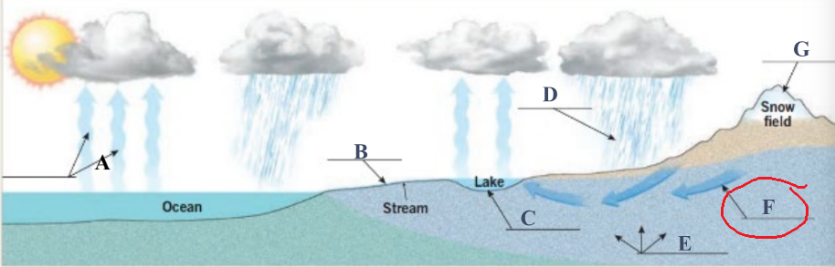
Groundwater
Water found underground in the cracks and spaces in soil, sand, and rock
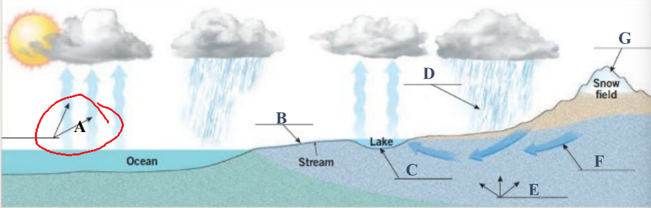
Evaporation
Water that changes from a liquid to a gas and moves from the Earth’s surface back into the atmosphere
Precipitation
Water that falls from the atmosphere to the Earth’s surface
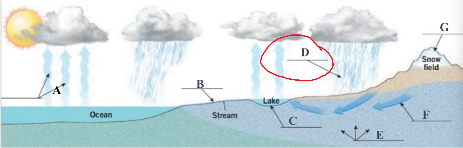
Reservoir
Storage of water that occurs on the land surface
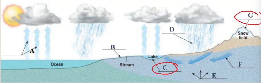
Where does storage of water occur?
Oceans, lakes, reservoirs, and glaciers
What direction do rivers flow?
Downhill
What direction are the shapes of the contours pointing?
Uphill (shaped like a V like its being poured out of a a triangle paper cup)
Gradient
Slope of a stream bed along its course (ex. a gradient of 5ft/mi has a vertical drop of 5 feet for every 1 horizontal mile)
Headwaters
Streams typically begin in the mountains
Mouth
End of a stream where it typically enters the sea, lake, or larger stream
Floodplain
A broad, flat area adjacent to river; flat area of sediment deposited by the stream, risk of flooding depending on river level
Stream channel
A long, narrow depression, shaped and filled by a stream
Stream banks
Sides of the channel
Stream bed
Bottom of the channel
Drainage system
A stream and its tributaries
Drainage basin
Each drainage system occupies a basin
Drainage divide
Imaginary line connecting points of highest elevation between two basins
Erosive power
A streams’s stream gradient and stream discharge, which is its rate of flow in units volume per tie
More erosion is caused by
Hgher gradients + higher discharde
Areas and divide of adjacent basins will stay constant if?
They have the same gradient and discharge
If gradients and discharge are different, the basins will:
shift toward the system with the lower gradient/discharge
Sinuous
How bendy a stream is (a straighter stream is less _____)
Cutbank
Where the stream flows fastest around a band and erodes away sediment
Point bar
Where the stream flows slowest around a bend and deposits sediment
Oxbow Lake
Cut off meander when stream pinches off due to erosion
Meander Scar
Remnants of a meander; an oxbow lake filled with sediment
How does groundwater flow?
Downhill
Water table contours
Show the elevation of the water table underground
Flow lines
Show the direction of groundwater flow, drawn directly across water table contours at 90 degrees
Glacier
Body of ice and snow formed on land that shows downslope or outward movement under the influence of gravity.
How do glaciers flow?
Downhill
Moraines
Accumulation of glacial debris (till) pushed along by ice flows
Lateral moraines
At the side of the glacier
Median moraine
In the middle of a glacier formed when two lateral moraines meet
Terminal moraine
A moraine at the furthest extent of the glacier
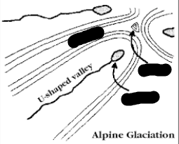
Arête
Narrow divide between two valleys: a ridgeline extending off a horn; smaller than a serrate divide
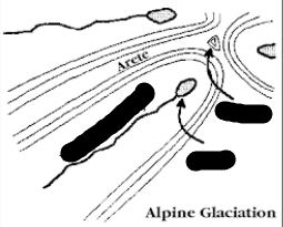
Horn
Pyramid shaped mountain peak at the head of a glacial valley: appears like a triangle on topographic maps
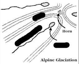
Serrate Divide
Large divide between headward regions of oppostelly sloping glacial vallets
Cirque
A bowl-like feature sitting in the crook of an arête
Tarn
A lake occupying a cirque
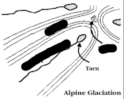
U-shaped valley
Glacially eroded valley
Hanging valley
Valley sitting upstream of a cliff
Outwash plain
Streams flowing from the terminus deposited sand and gravel beyond the front of the glacier
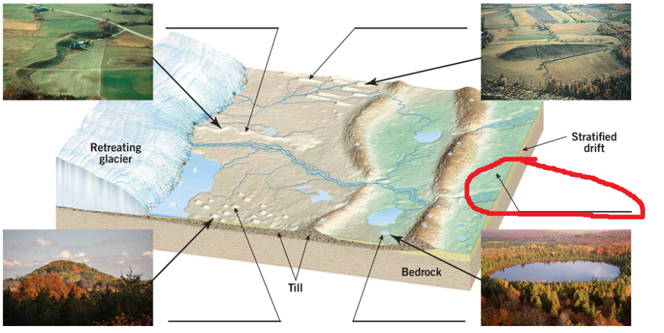
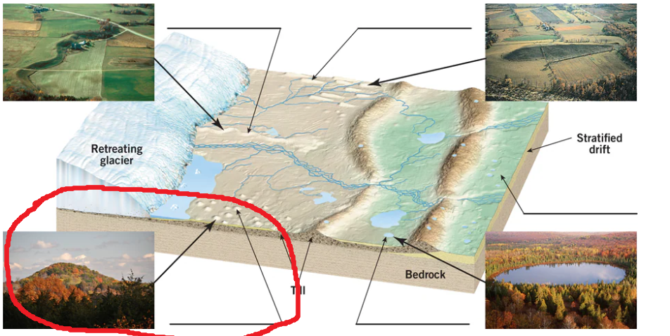
Drumlin
Elongate/steamlined hill parallel to direction of ice movement
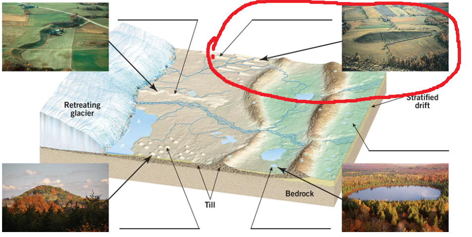
Kettle
Ice block pit in an end moraine- can also fill with water to form ______ lakes
Esker
Long, sinuous ridge of water-deposited sediment

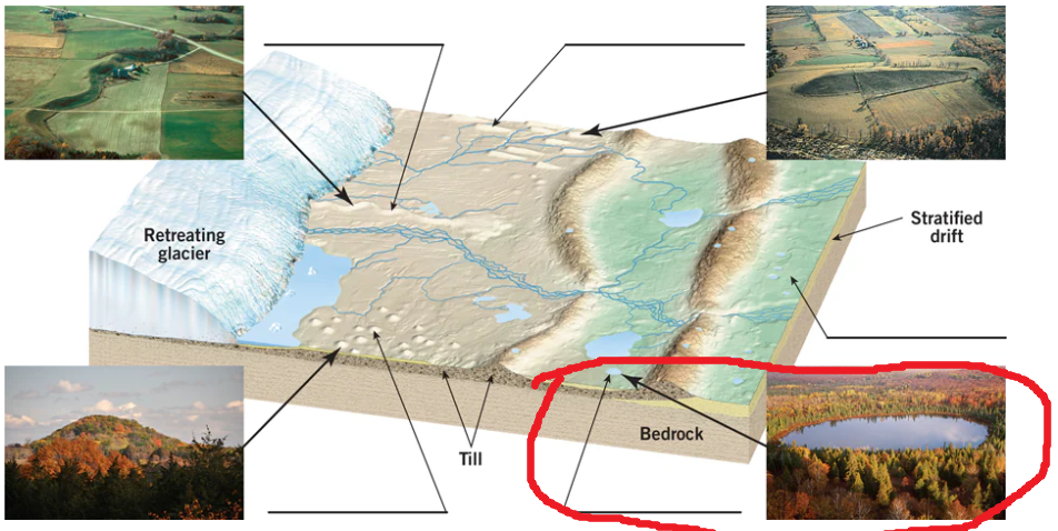
Glacial Drift
All rock material transported by a glacier and deposited directly from the ice (till) or by meltwater from the glacier (outwash)
Kame
Steep-sided hill made when outwash collects in stagnant glacial ice
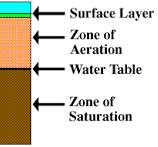
Where is the Zone of aeration, water table, and zone of saturation?
Zone of aeration is above water table and zone of saturation is below water table
Earthquake
A violent and abrupt shaking of the ground, caused by movement between tectonic plates along a fault line in the earth’s crust
Plate tectonics
Rigid plates that make up the casing of the eath, and teir movement with respect to one another
What do plate tectonics explain?
The origin and distribution of volcanoes and earthquakes, topography of the seafloor, and other geologic features
Crust/lithosphere
Solid, thin layer of rock on earth’s surface, where we live
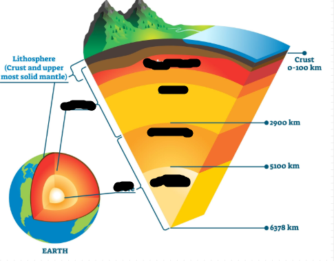
Mantle
Solid (not liquid, but “flows” slowly), thickest layer of the earth, interaction with crust causes plate movement
Outer core
Liquid, iron-nickel layer, works with inner core to generate an electromagnetic field (which allows us to have an atmosphere)
Inner core
Solid, iron-nickel sphere, works with the outer core to generate an electromagnetic field
Divergent plate
Two plates moving away from eachother
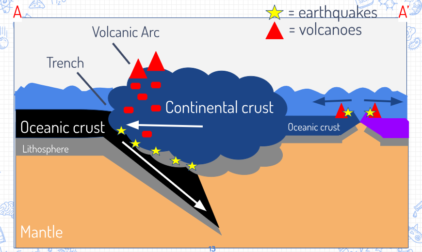
Subduction/Convergent
Two plates are moving towards each other. One plate sinks into the mantle (subducting plate) while the other overrides
Transform
Two plates sliding past each other

1
Eurasian plate

2
Philippine plate

3

4
Pacific plate

5
Juan de Fuca

6
Cocos plate

7
Nazca plate

8
Antarctic plate

9
North American plate

10
Caribbean plate

11
South American Plate

12
African plate

13
Arabian Plate

14
Australian-Indian plate

15
Eurasian plate
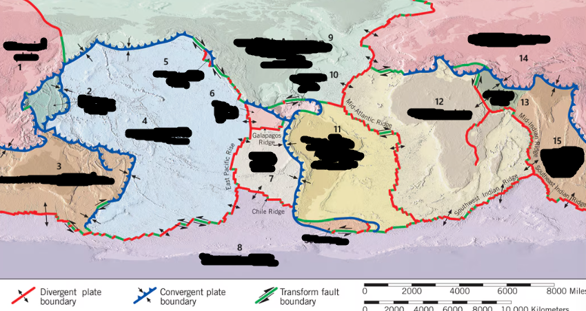
16 (actually unlabeled)
Scotia plate
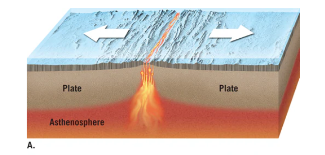
Divergent plate
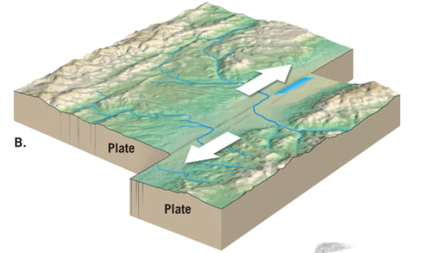
Transform
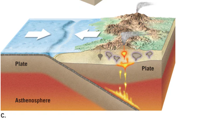
Convergent
Draw the subduction zone
1st step to calculate the rate of seafloor spreading
Measure from a spot at which the plate is spreading outward to a spot with a known age point
2nd step to calculate the rate of seafloor spreading
Use the map’s scale to convert the measurement into actual inches of spreading over that time period
3rd step to calculate the rate of seafloor spreading
Divide the distance the sea floor spread by the time it took the spread that far, to find the rate of spreading per year = the distance the sea floor moves / length of time
What is the spreading rate between two plates using magnetic anomalies
1 km/mya divided by 10 = 0.1 cm/yr
Physical layers of the earth from outside to inside
Lithosphere (Crust + brittle mantle), Asthenosphere, Mesosphere, Outer Core, Inner Core
What is the crust made of?
Oceanic : Basalt, Continental : Granite
What is the mantle made of?
Peridotite
What is the core made of?
Iron and nickel alloy
Which body wave of an earthquake moves faster?
P waves
Which body wave of an earthquake moves slower?
S waves
What way do P-waves vibrate?
Parallel
What way do S waves vibrate?
Perpendicular
Which body wave has a higher amplitude?
P waves
The velocity of P waves and S waves ___ with increased depth in the lithosphere.
Increase
Does the velocity of P waves and S waves increase or decrease immediately below the lithosphere?
Decrease
Does the change in velocity of seismic waves as they enter the asthenosphere indicate that the asthenosphere is more or less rigid than the lithosphere?
The asthenosphere is ______ rigid than the lithosphere.
Less
How does the velocity of seismic waves change with increasing depth in the lower mantle?
Slowly increases
Does the change in velocity of seismic waves with increasing depth in the lower mantle indicate that the rock in the mantle becomes more or less rigid with depth?
The rock in the mantle becomes ____ rigid with depth.
More