Oceanography Exam 1 Flashcards
1/80
There's no tags or description
Looks like no tags are added yet.
Name | Mastery | Learn | Test | Matching | Spaced |
|---|
No study sessions yet.
81 Terms
What makes Earth habitable?
goldilocks zone (right size and distance from sun) gives us liquid water, the right temperature, an atmosphere, nutrients, gravity, and a magnetic field.
What is the Big Bang theory?
universe began 14 billion years ago from a hot, dense point that expanded. evidence includes cosmic background radiation, the expanding universe, and abundance of light elements.
What is Nebular Theory?
solar system formed 4.5 billion years ago when a giant could of gas and dust collapsed, spun into a disk, and formed the Sun at the center. Planets formed from leftover material
What is planet accretion?
Dust and rock clumped together into planetesimals, which collided and stuck forming earth. A mars-sized mass (theia) later hit earth, creating the moon.
How does Earth’s composition compare to the Sun and Universe?
The Universe and Sun are mostly hydrogen and helium. Earth is mostly heavy elements (iron, oxygen, silicon, magnesium). Earth is heterogeneous (layered, not the same throughout).
Why is Earth layered?
Heat from collisions, gravity, and radioactive decay melted early Earth. Dense materials (iron, nickel) sank to the core, while lighter materials (silicon, aluminum, magnesium) floated outward.
What are Earth’s main layers?
Crust (thin, solid, outer), mantle (thick, solid but flows), and core (iron-rich, outer core liquid, inner core solid).
How did Earth’s atmosphere form?
First atmosphere (H & He) escaped. Later, volcanoes released gases like water vapor, CO₂, and SO₂. Life later added oxygen.
How did Earth’s oceans form?
Water vapor condensed and fell as rain. Extra water likely came from icy comets and asteroids. Rain mixed with volcanic gases made early oceans acidic and salty.
What major evidence did Alfred Wegener use to support his theory of continental drift?
fit of the continents, similar fossils, similar rocks, and surprising geology
Why was Wegener’s theory of continental drift not immediately accepted?
He couldn’t explain how the continents moved, he was not a geologist, scientists thought the mantle wouldn’t let the continents move
What was Harry Hess’ theory of seafloor spreading?
new seafloor is created at mid ocean ridges where molten rock rises cools then spreads outward pushing continents apart. Old seafloor sinks back into trenches
What data supported seafloor spreading theory?
sonar maps showing mid ocean ridges and trenches, dating of seafloor rocks, sediment thickness, and magnetic striping
how did technology advance our understanding of plate tectonics?
sonar mapping revealed mid ocean ridges and trenches, radiometric dating showed seafloor was much younger than continents, magnetometers detected magnetic striping that supported seafloor spreading, earthquake mapping (Benioff zones) showed deep quakes along subduction zones proving the crust moves in plates, and later satellites and gps confirmed that continents are still moving today.
How do continental and oceanic crust differ?
continental crust is thicker, older, mostly made of granite, and less dense. Oceanic crust is thinner, young, and made of dense basalt.
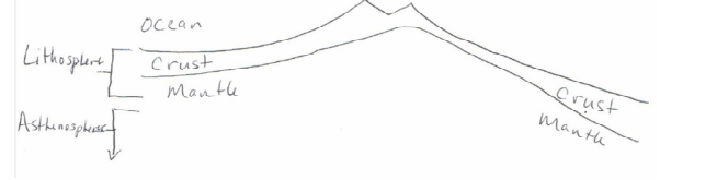
how does the lithosphere differ from the asthenosphere?
lithosphere is the rigid outer layer, includes the crust and upper mantle, and is broken into tectonic plates. the asthenosphere is weak and ductile below the lithosphere and can slowly flow in convection cells.
what mechanisms drive the movement of lithospheric plates?
mantle convection, ridge push, and slab pull
what is mantle convection?
Hot rock rises, cool rock sinks, circulating slowly.
what is ridge push?
Weight of elevated lithosphere near ridges pushes older plate away.
what is slab pull?
Dense, sinking lithosphere at subduction zones pulls the rest of the plate down (the strongest force).
What are the three types of plate boundaries?
divergent, convergent, and transform
what is a divergent plate boundary?
plates move apart, new crust forms
what is a convergent plate boundary?
plates move toward each other, subduction or mountain building
what is a transform plate boundary?
plates slide past each other
what is a real world example of a divergent plate boundary?
mid Atlantic ride, east African rift valley
what is a real world example of a convergent plate boundary?
Andes (oceanic-continental), Aleutian islands (oceanic-oceanic), Himalayas (continental, continental)
what is a real world example of a transform plate boundary?
San Andreas Fault in Califfornia
Divergent Plate Boundary
Convergent Plate Boundary
How do scientists determine the speed of plate motion?
magnetic declination and inclination rocks (paleomagnetism), magnetic striping patterns on the seafloor, hotspots and age of volcanic island chains, direct measurements with gps satellites.
what is the range of measured plate speeds?
plates move at a few centimeters to tens of centimeters per year
what are the stages of the Wilson cycle?
embryonic, juvenile, mature, declining, terminal, and suturing
what is the embryonic stage of the wilson cycle?
A hotspot stretches and splits a continent
what is the juvenile stage of the wilson cycle?
A narrow sea forms between continents
what is the mature stage of the wilson cycle?
A wide ocean basin forms with passive margins
what is the declining stage of the wilson cycle?
Subduction begins, shrinking the basin
what is the terminal stage of the wilson cycle?
Most of the ocean is subducted; continents about to collide
what is the suturing stage of the wilson cycle?
Continents collide, ocean completely gone, mountains form
what is a modern example of the embryonic stage?
east african rift
what is a modern example of the juvenile stage?
red sea
what is a modern example of the mature stage?
atlantic ocean, arctic ocean
what is a modern example of the declining stage?
pacific ocean
what is a modern example of the terminal stage?
mediterranean sea
what is a modern example of the suturing stage?
himalayas (india colliding with asia)
what are the 5 major ocean basins?
pacific, indian, arctic, southern, atlantic
order the ocean basins from largest to smallest
pacific, atantic, indian, southern, arctic
what ocean basin is on the left of north and south america and right of asia and australia?
pacific
what ocean basin is on the right of north and south america and left of africa and europe?
atlantic
what ocean basin is to the right of africa, beneath asia, and to the left of australia?
indian
what ocean basin is above antarctica and below all other continents?
southern
what ocean basin is above all continents?
arctic
what are the special characteristics of the pacific ocean basin?
Largest, deepest, volcanic island arcs, trenches, little freshwater input.
what are the special characteristics of the atlantic ocean basin?
Second largest, major freshwater rivers flow into it, few marginal seas
what are the special characteristics of the indian ocean basin?
Third largest, lots of sediment from Ganges & Indus, few marginal seas
what are the special characteristics of the southern ocean basin?
Coldest, surrounds Antarctica, very biologically productive, sea ice.
what are the special characteristics of the arctic ocean basin?
Smallest, shallow, land-locked, ice-covered, large sediment input from glaciers.
what are he method used to map the seafloor?
weighted lines, echo sounding, multibeam sonar, side-scan sonar, and satellite mapping
what are the strengths and weaknesses of weighted lines?
an early method that was simple but slow, dangerous, and provided limited detail
what are the strengths and weaknesses of echo sounding (sonar)
uses sound pulses; is faster and more accurate than weighted lines TEXTBOOK FOR WEAKNESSES
what are the strengths and weaknesses of multibeam sonar
creates wide “swaths” of seafloor detail, but only where ships tavel
what are the strengths and weaknesses of side-scan sonar
captures detailed images to the side but leaves a gap directly beneath the instrument
what are the strengths and weaknesses of satellite mapping
coves the whole ocean surface by detecting sea-surface height changes due to gravity, but resolution is lower than ship sonar
what are the 3 major ocean provinces?
continental margin, deep ocean basin, and mid ocean ridge
what are the subdivisions and major features of the continental margin?
continental shelf (shallow, flat), shelf break (edge), continental slope (steep dropdown), and continental rise (where sediment accumulates under slope)
what are the subdivisions and major features of the deep ocean basin?
also called the abyssal plains (flat, deep), has abyssal hills, seamounts (underwater volcanoes), guyots (flat-topped seamounts), and trenches
what are the subdivisions and major features of the mid ocean ridge?
the longest mountain chain on earth with hydrothermal vents (black and white smokers) where new crust forms
How do active and passive continental margins differ in tectonic activity?
little tectonic activity with wide shelves vs near plate boundaries, tectonically active with volcanoes, earthquakes, and trenches, narrow shelves
How do active and passive continental margins differ in sediment accumulation?
think sediment accumulations (east coast) vs less sediment (west coast of south america, san andreas fault)
What are interplane features?
seamounts and guyots
How do seamounts form?
Underwater volcanoes that rise ≥1 km above the seafloor
how do guyots form?
Seamounts that once reached the surface, were eroded flat by waves, then sank below sea level due to cooling and subsidence.
how does the hypsographic curve describe the height of land, depth of ocean, and earth’s land/sea coverage?
it shows a bimodal distribution: average land height is ~840 m above sea level, while average ocean depth is ~3,700 m below sea level.
About 70% of Earth’s surface is covered by ocean and ~30% by land.
If sea level rose 1,000 m, only ~7% of land would remain above water.
Differences reflect isostasy: continental crust is thick and light (granite), oceanic crust is thin and dense (basalt).
Why do oceanographers collect and study sediments?
they record earth’s history. as it accumulates, they preserve information about past climate, plate tectonics, and evolution. Can help oceanographers reconstruct past environments and major events.
How are sediments collected from the seafloor?
dredges (early method, shoveled up but looses integrity of sediment), corers (hollow tubes that preserve layers), and drilling (gets deep cores that are archived for research)
how do scientists classify sediments?
texture, origin, and mineral composition
What are the 4 major types of sediments?
lithogenic, biogenic, and hydrogenic, and cosmogenic
What is the origin, abundance, and distribution of lithogenic sediment?
From weathering of land rocks. ~85% delivered by rivers, some by wind, ice, or gravity. Abundant near continents and river mouths.
What is the origin, abundance, and distribution of biogenic sediment?
From shells and skeletons of organisms (e.g., diatoms, forams, coccolithophores). Found in high productivity zones (equator, polar seas, upwelling zones). Can form oozes if >30% skeletal remains.
What is the origin, abundance, and distribution of hydrogenic sediment?
From chemical precipitation in seawater (e.g., manganese nodules, ooids, evaporites). Found scattered, less abundant but widespread.
What is the origin, abundance, and distribution of cosmogenic sediment?
from space (micrometeorites, tektites), very rare, globally dispersed in tiny amounts.
how do siliceous oozes differ from carbonate oozes?
silicious oozes are made of silica tests from diatoms and radiolarians, found in deep oceans under areas of high productivity, and dissolve easily so you need high supply to accumulate. carbonate oozes are made of calciumm carbonate tests from coccolithophores and formainfera, found above the calcite compensation depth (CCD) (below it they dissolve and no ooze forms), distribution is linked to the mid ocean ridges.