UNIT 2
1/212
There's no tags or description
Looks like no tags are added yet.
Name | Mastery | Learn | Test | Matching | Spaced | Call with Kai |
|---|
No analytics yet
Send a link to your students to track their progress
213 Terms
Hydrologic Cycle
It is the continuous circulation of water between the Earth’s spheres. It includes the aftermath of precipitation (A.K.A. rainfall or snow) falling on land. They either:
Go through surface run-off
Infiltration (Water absorbed into ground)
Evaporate
Absorb into plant and animal tissues
The four major ocean basins
Atlantic, Pacific, Indian, and Arctic Oceans.
Pacific Ocean
The largest and deepest ocean on Earth. It is half of the ocean surface area of Earth.
The Atlantic Ocean
2nd largest ocean. Half the size of the pacific, and not as deep. Is considered narrow and is in between the shores or margins of continents.
The Indian Ocean
3rd largest ocean. Smaller than the Atlantic but also as deep as it. Uniquely, it is a body of water part of the Southern Hemisphere.
The Arctic Ocean
The 4th largest, or the smallest ocean. Not as deep as the rest of the oceans.
Composition of Seawater
35% Salinity (Amount of solid materials dissolved in water). NaCl (Salt) along with other salt types comprise of 99% of the dissolved water in the sea.
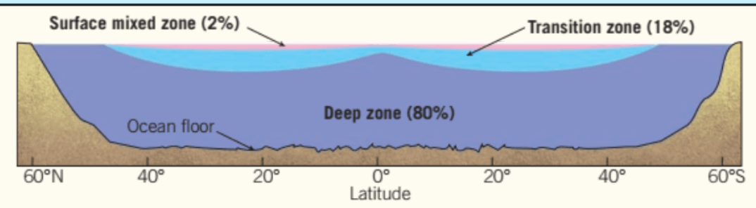
Ocean Layering
Surface Mixed Zone: Warm and uniform temperatures.
Transition Zone: Includes a thermocline (transition between the warmer mixed zone water and cooler deep zone water.) and a pycnocline (separation between the two densities of the liquids.)
Deep Zone: Cold and deep, 80% of all ocean water depth.
Freshwater sources
Usually in inaccessible areas such as high mountain tops and polar regions (glaciers). Readily available sources are found in surface water and ground water reservoirs.
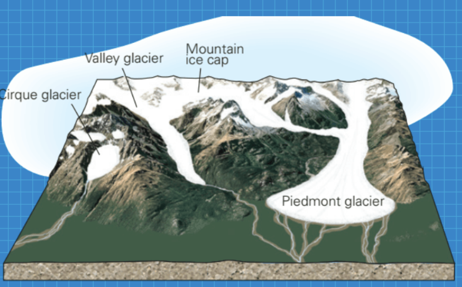
Glaciers
Glaciers are formed from long lasting compaction of ice and snow that forms on land masses.
Ice Shelf
A floating extension of land ice.
Mountain Glaciers
A type of glacier that is formed on a mountain. There are different types of them, Cirque, Valley, Mountain Ice Cap, and Piedmont.
Continental Glacier
A type of glacier that covers a very, very, large mass of land (More than 50,000 square km) Only exists in Greenland and Antartica.
Surface Water
It is the lakes, streams, rivers, where water from rainfall and melting snow flows to.
Permafrost
A permanently frozen layer of ice on or under Earth’s surface.
Stream & River
Natural bodies of water that flow continuously in a channel into larger bodies of water such as oceans or lakes, usually down a slope.
Rivers are large streams that get water flown in through smaller streams called tributaries.
Meandering River
A river that is a continuous flow with twists and turns.
Braided River
A river channel that is made of smaller channels.
Lakes
A large body of water usually enclosed by land masses. It occupies the depression of a land mass.
Lake water comes from rain, melting snow and ice, and streams.
They contain freshwater
Oligotrophic Lake
A deep like that lacks nutrients and is made of pure water, so it does not have many living life forms.
Eutrophic lake
A lake that contains an abundance of nutrients, sustaining living organisms.
Wetlands
Biologically diverse environments that sustain many living organisms. It remains flooded or soaked either through the year or in specific seasons. Includes:
Swamps, marshes, mudflats, floodplains, Estuary
Swamps
A type of wetland that is dominated by lush trees and vegetation. It is found in low lying areas beside slow moving rivers.
Estuary
A wetland coastal area where freshwater from the river/stream meat saltwater from the ocean.
Marsh
A shallow wetland near lakes that are covered in grasses and weeds are dominant in vegetation.
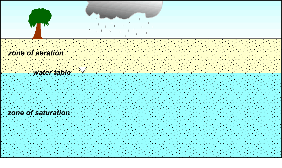
Groundwater
Largest reservoir of freshwater for humans to use. Found underground. Comes from rain or snow, or water seeping into the ground
Zone of Saturation: At the bottom where the water is located. It fills the pores and rock fractures.
Zone of Aeration: Above the water table where the soil is mostly filled with air.
Water Table: The boundary that separates groundwater from the surface
Porosity
The empty spaces between rock pores. High porosity = larger pores
Permeability
Ability of a rock for water or sediments to pass through. High permeability = more passes through
Aquifers
A body of rock that can hold a large quantity of groundwater. It has to be both porous and permeable.
Artesian Wells
A well drilled into a contained aquifer so waters can rise without pressure, and sometimes flow to the top for human consumption
Springs
When ground water’s water table is at the land surface, so it seeps to the surface and creates streams or small bodies of water.
Clean water act
The Philippines Clean Water act aims to protect natural bodies of water from pollution.
Order of the Earth’s layer
Crust
Mantle
Lithosphere
Asthenosphere
Core
Crust
The outermost layer of the earth
Mantle
Hot, slow flowing solid layer between the crust and the core
Lithosphere
The rigid outer layer of the Earth which consists of the crust and upper mantle
Asthenosphere
A zone in the mantle just below the lithosphere that behaves like a viscous fluid, which cause the mantle rock to be softest and weakest.
Core
The center of the Earth. The inner core is solid, the outer core is liquid.
Continental drift
Alfred Wegener suggested the theory that the super continent Pangea (which comprised of every continent stuck together) slowly drifted apart throughout millions of years. This movement is driven by tectonic forces and results in the current positions of continents.
Jigsaw Puzzle Piece
An evidence of the super continental drift theory | The coast of continents such as South America, Africa, and North America fit together like puzzle pieces. In theory, it demonstrates how they were once connected
Distribution of Fossils
An evidence of the super continental drift theory | Similar or same fossil types were found on different continents. It suggest that these animals were able to freely roam around the “Pangea” land mass.
Rock Type and Geological Features
An evidence of the super continental drift theory | Where coastlines are facing one another, mountain belts and similar geological structures appear across these continents.
Paleoclimate
An evidence of the super continental drift theory | Coal deposits have been found in areas that do not have tropical climate, proving that these continents have been moving around.
Rejection of the continental drift
No credible mechanism for the drift
Continents do not break through ocean floor
Tidal energy is too weak to displace large land masses
Theory of Tectonic plates
It is the theory that the lithosphere is divided into 7 major tectonic plates, and they move relative to each other on top of the asthenosphere.
Earth’s Major Plates
7 Large plates, 7 mid sized plates, and many small sized plates. They meet at boundaries that may either be divergent, convergent, or transform
Divergent Plate Boundaries (Constructive)
These are regions that move AWAY from each other, allowing magma from the inner Earth and generate new slivers of sea floor. However, this can also happen on land and not just the sea floor. They are characterized by volcanic activity and the formation of new crust as tectonic plates separate.
Convergent Plate Boundaries (Destructive)
Two plates that move against EACH OTHER. The leading edge slides on top while the other one is slide beneath it. There are three types, Ocean-ocean, Ocean-continental, and Continental-continental convergence
Oceanic-oceanic Convergence
A type of convergence that happens when two oceanic plates collide. The older one slides under, into the lithosphere. This process form volcanic island arcs.
Oceanic-Continental Convergence
A type of convergence that occurs when an oceanic plate and a continental plate collide. The oceanic one slides underneath, and volcanoes form on the continental plate.
Continental-Continental Convergence
A type of convergence that happens when two continental plates collide, forming a new mountain belt.
Transform Plate boundaries
Lithospheric plates that slide against each other, side to side as divergence or convergence happens.
Testing the plate tectonics model
Includes ocean drilling, mantle plume and hotspot, and paleomagnetism.
Ocean Drillng
A method that has found out that age of the sea floor increases with distance from a mid-ocean ridge. It involves extracting core samples from the ocean floor to study geological and biological processes.
Mantle Plume & Hotspot
Hotspot: An area of volcanic activity where a mantle plume reaches the surface. Volcanism provides evidence of both the direction and rate of plate movement over time.
Paleomagnetism
Rock layers which change relative to the Earth’s magnetic field and poles over time.
Why do great slabs of lithosphere move
They move due to convection. Convection refers to the circulating fluid in response to heating and cooling. Convection in the mantle move the fluid in different direction, moving the lithosphere in a process called subduction. The cooler, older, denser edge of the lithosphere sinks back into the mantle.
Earthquake
The ground shaking as a result of the sudden and rapid movement of tectonic plates rubbing against each other along fractures in the Earth’s crust (faults)
Hypocenter
Location in the Earth’s crust where an earthquake originates. AKA Focus.
Epicenter
The point on the Earth’s surface directly above the hypocenter.
Directions of fault movements
Faults: fractures in a rock with movement along them can occur in several directions, including horizontal, vertical, or oblique movements.
Causes of Earthquakes
Elastic rebound: Stress of rocks which cause it to fracture, and rebound as soon as it is broken.
Seismology
The study of Earthquakes and Earth’s interior based on evidence from seismic waves
Seismograph
Records seismic waves.
Seismograph
Physical or digital record of earthquake waves as measured by a seismograph.
Seismic waves
Waves of energy generated by earthquakes. Two types, namely: Surface and body waves.
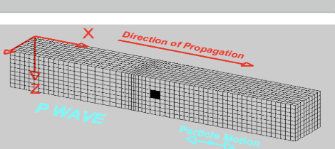
Body waves
Seismic waves that travel through the Earth's interior, including primary (P) waves and secondary (S) waves. Faster than Surface waves
P waves
A type of body wave. When rocks are compressed in the direction of travel. CAN travel through solid, liquid, and gas. Fastest wave
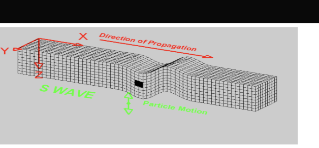
S Waves
A type of body wave. Moves in the perpendicular direction of travel. Like a snake motion. Can ONLY pass through solids, not liquids and gases.
Surface waves
Only move through the Earth’s surface. Include Rayleigh waves and love waves. They are responsible for most of the damage during an earthquake due to their amplitude and duration.
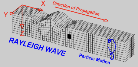
Rayleigh Waves
A type of surface wave. Compress and dialate near the surface. Perpendicular to direction of travel.
Love waves
A type of surface wave that causes back and forth shear motion in a horizontal plane, moving side to side.
Modified Mercalli Scale
A scale that measures the intensity of an earthquake based on the damage it causes to buildings and people.
Richter Scale
Measures an earthquake’s intensity based on the amplitude of the largest seismic wave recorded on the seismogram
Tectonic Stress
The force exerted against an object. Rocks can deform elastically or plastically. Creates three structures: Folds, faults, and joints
Compressional Stress:
Squeezes rock together.
Tensional Stress
Stretches rock apart
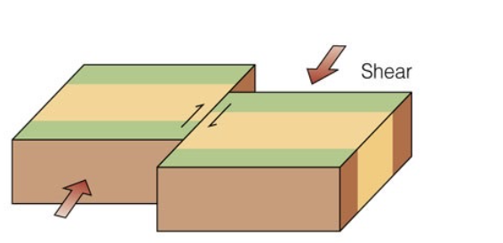
Shear Stress
Causes sliding and tearing of rock mass.
Folds
A bend in rock layers caused by compressional stress, resulting in various shapes and structures. Parts:
Limbs: Side of a fold in a rock
Anticline: Fold in a rock that arches upward
Syncline: Fold that arches downward
Fault
A fracture in rock where movement has occurred, typically caused by stress, resulting in displacement of the rock on either side.
Joints
Fractures in rock where no movement has occurred, often leading to secondary processes like weathering and erosion.
Volcanism
The process of magma movement from beneath the Earth's surface to create volcanic eruptions, including the formation of volcanoes and lava flows.
Viscosity of lava
Differences based on silica content; high silica = more viscous.
Types of Lava Flows
Pahoehoe: Smooth, ropy lava.
Aa: Rough, jagged lava flow.
Magma Formation and Eruptions
Magma formation occurs when heat and pressure cause rocks in the Earth's mantle to melt, leading to volcanic eruptions when magma reaches the surface.
Conditions for Melting
Increase in temperature, lower pressure, and addition of water can lead to melting of solid rock.These conditions decrease the melting point of rocks, facilitating magma formation.
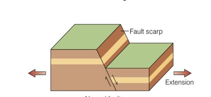
Normal fault
Reverse Fault

Thrust Fault
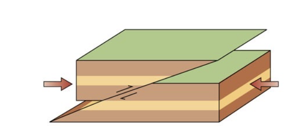
Right-Lateral-Strike-Slip fault
Erosion
It is the process where weathered sediments are transported after weathering by agents of erosion.
Main agents of erosion
Water, wind, glacier
Splash erosion
A water agent of erosion | When raindrops cause soil to detach from its main mass, and jump out into another area
Sheet erosion
A water agent of erosion | Raindrops break apart the soil structure and create a thin layer of soil loss across a large area, often moving down a slope
Gully erosion
A water agent of erosion | After heavy rain, water flows into small channels, further eroding it and forming a deeper dent into the Earth.
Valley erosion
A water agent of erosion | Downward movement of water along multiple slopes into a common ditch, further deepening the valley.
Bank erosion
A water agent of erosion | When the continuous flow of water erodes the banks (edge/side) of streams and rivers.
Coastline erosion
A water agent of erosion | When waves from the sea crash into a coastline, breaking it down into rocks and carrying the sediments into the ocean.
Seaside cliff erosion
A water agent of erosion | When ocean waves batter the base of seaside cliffs, boring holes into the rock, creating waves
Glacier Erosion
When rocks embedded into the ice scrape bedrock, cutting deep parallel grooves. Can erode land through plucking and abrasion