SC 211 Earth and Space - Test 2
1/76
There's no tags or description
Looks like no tags are added yet.
Name | Mastery | Learn | Test | Matching | Spaced | Call with Kai |
|---|
No analytics yet
Send a link to your students to track their progress
77 Terms
Tectonic movement: Types of deformation
Fault
Folding
Fault
A fracture surface which has had motion
Abrupt ending and displacement of sediments
Types of faults
Normal: hanging wall slips downward relative to the footwall
Reverse: hanging wall moving upward relative to the footwall
Strike-slip: rock masses moving horizontally
Footwall: underneath the fault line
Hanging wall: above fault line
Fault scarps
Cliffs along normal or reverse faults
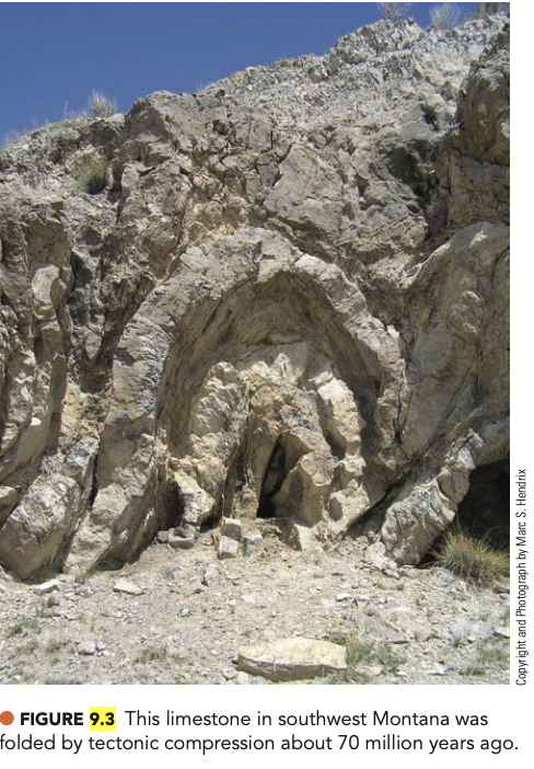
Folding
Caused by slow continuous movement
Types of folding
Syncline: trough - fold downward
Anticline: arch - fold upward
Volcanic mountains
Come produced by volcanic deposits
Mauna Ka
gunung paling tinggi di Hawaii and North America, lbih tinge dri Everest klo dihitung dri bawa air laut
Fault-block mountains
Formed by normal and reverse faults
Teton mountains (contoh pegunungan)
Folded mountains
Folding of continental (formed Karena)
Rocky mountains (contoh pegunungan)
Continental drift
The shape of plates and sediments indicates there was once supercontinent, Pangea
Pangea broke apart into Laurasia and Gondwana
dulu bumi ada 1 tanah api continentnya drift apart
These changes occurred during the flood
Continental drift: the flood - Catastrophic Plate Tectonics
Rapid movements of continental and oceanic crust producing tsunamis and global erosion sedimentation (krn ada rapid mantle movement)
Blankets of water-lain, extensive fossil-bearing sedimentary packages across the continents
buktinya banyak marine creatures buried with dinosaurs
Antonio Sneider proposed continents separating because of the flood
Wegener proposed continents were once connected in a single supercontinent, Pangaea, before breaking apart
Antonio sneider
proposed continents separating because of the flood
(Alfred) Wegener
suggesting continents were once connected in a single supercontinent, Pangaea, before breaking apart
Plate tectonics: Lithosphere
Crust and outermost part of the mantle
Rigid
Plate tectonics: Asthenosphere
dibawah lithosphere, asthenia = weak
Soft rock below the lithosphere in the upper mantle
Solid rock that flow (kyk silly putty)
carries the lithosphere on top while it flow, hear within the core drags the continent apart
The seafloor spreading hypothesis
Very young (formed during the flood)
Features that indicate the ocean floors have spread out
Features that indicate the ocean flows have spread out
Mid-ocean ridges (divergent)
underwater (volcanic) mountain chain.Trenches (convergent)
deepest trench everest gbkl keliatan dari atas air, convergent = traveling towards each otherIsland arcs (convergent)
island formed from volcanoesMagnetic ridges (divergent)
seafloor spread showed by ridges (magnetic minerals solidifies) evidencing that the magnetic field (north & south) have changed
Plate tectonics
Study of crustal movement as a result of ocean floor expansion
Lithosphere is broken into 7 major plates
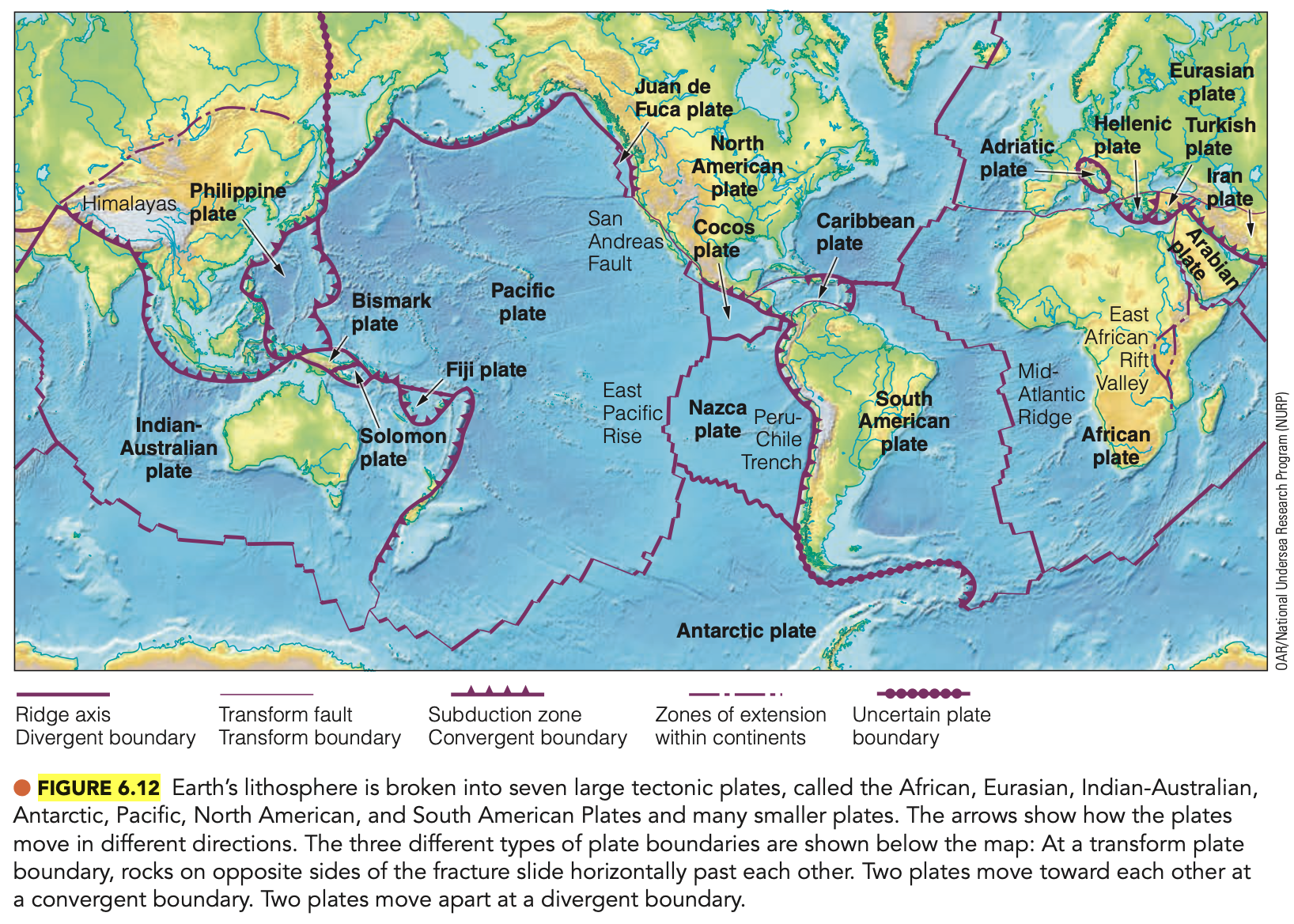
Plate tectonics: the lithosphere
Oceanic: basalt (denser, heavier than granite)
Continental: granite
Plate collisions
Oceanic continental plate collision
Oceanic-oceanic plate collision
Continental-continental plate collision
Plate collision - oceanic continental plate collision
Subduction zones
when collide, oceanic slides underneath
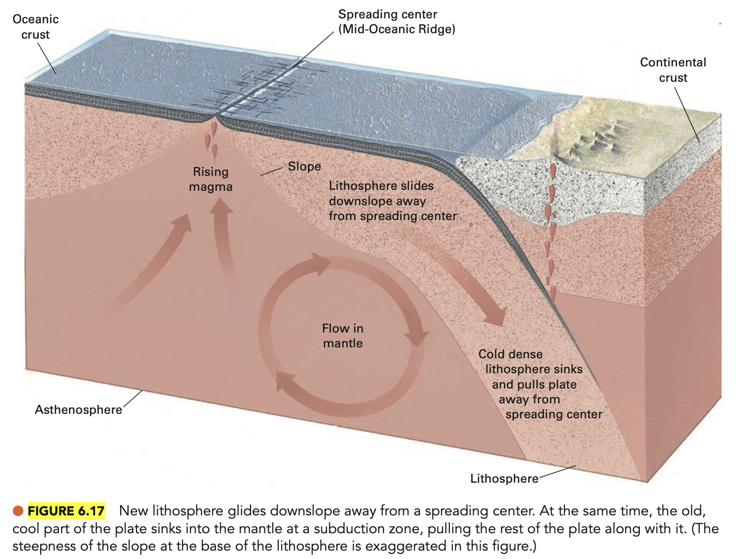
Plate collision - oceanic-oceanic plate collision
Island arcs
which one is older = further than the sea floor is older, the older is more compact and has more time to cool = will subduct (slide under)
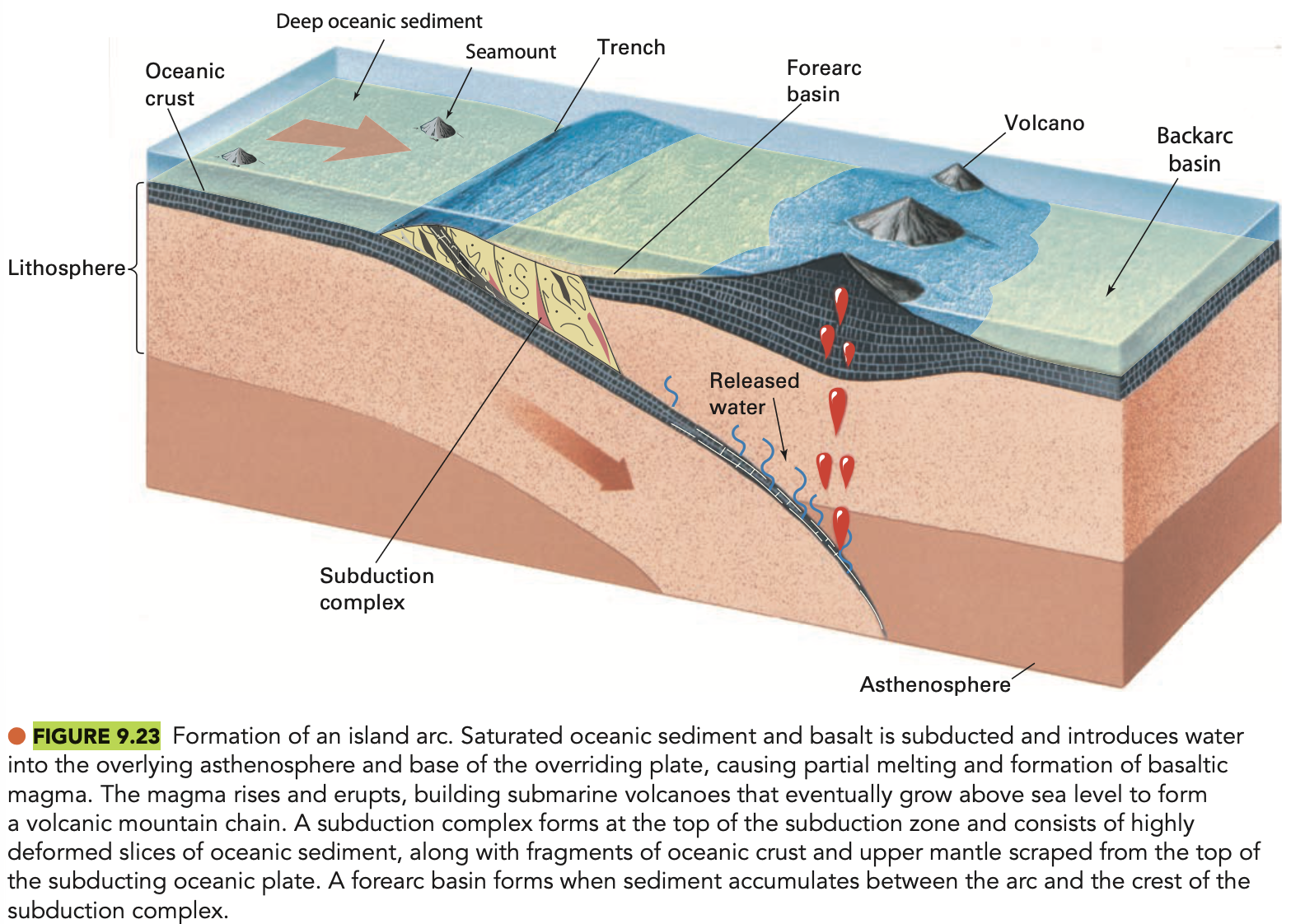
Plate collision - continental-continental plate collisions
Folded mountains
from 3 types of mountain, folded mountains are formed from continental-continental collisions,
Plate tectonics: Transform faults
San Andreas faults
a special variety of a strike slip fault: occurs when two plates slip against each other
Plate tectonics: The future
Book’s perspective: Continents will gradually change
Biblical perspective: The earth will never see the same type of crustal changes that we see evidence of
będą karena the global flood gabakal kejadian lagi
(Georges) Cuvier
dia French scientist
Studies fossils
Concluded catastrophes had killed out each successive fossil layer
New creatures were created supernaturally
Hutton
dia Scottish Geologis
“I see no vestige of a beginning, no prospect of an end”
Used vast amount of time to explain away special creation
Lyell
tulis one of the first geology book “Principles of Geology”
“Explain the former changes of the earth’s surface by forces now in operation”
Uniformitarianism
“The present is the key to understanding the past”
Darwin
Theory of evolution
provided the mechanism of evolutionAllowed a supernatural creation of the creatures in the fossil record to be discarded
Rock formation: Principles of reading the rocks
Lowest is oldest
Beds were laid horizontally
Movement took place after being laid
Igneous intrusions are younger
karena in order to be an igneous intrusion, there has to be something to intrude
Rock formation: Unconformity
An irregular surface, separation two series of rocks
Unconformity: Evolutionary perspective
Evolutionary perspective: a significant time gap int he rock record where sediment was not deposited or was eroded
Unconformity: Biblical perspective
Sediments were laid down by the flood from different areas and cut through floodwaters
Biblical perspective: bukti flood
Deep and wide erosion
Marine animals far above sea level and throughout continents
Sand carried across continents
Radiometric dating - Radiometric decay
A clock based on radioactive decay
Change of parent element into a daughter element
Happens at a particular rate (Half-life)
By comparing the parent element to the daughter element, a date is assigned
Organic material uses C-14 dating
Other rocks use Rb-Sr, U-Pb, K-Ar
Radiometric decay: organic material dating
C-14 dating
Radiometric decay: other rocks dating
Rb-Sr, U-Pb, K-Ar
Radiometric dating - Assumptions
Assume constant rate of decay
Assume nothing comes into or leaves the system
Assume no daughter element present at beginning
Assume initial conditions can be predicted
All of these assumptions are contrary to natural world observations
Radiometric decay - Testing the ages
Radiometric data never used on sedimentary rock surrounding fossils or on fossils presumed to be older than 60,000 years
a. All fossils ever tested have 14C
b. Implications: all fossils are younger than 60,000 yearsRocks of known ages measures significantly older than what they are
a. Implication: daughter element present as the beginning
b. Measured ages cannot be trusted
Fossils
Organisms buried in rock layers (permineralization)
95% of fossils are marine creatures
Organisms buried in rock layers through the process of…
Permineralization
Fossils - shows progressive change through the rock layers
Complexity seems to decrease in rock layers
The Geologic Time Scale - Extinction
One type of organism rapidly decreases to be replaced by another (ini evolutionist view)
Indicates a change in location as the floodwaters prevailed
one extinction event, but ada different layers krn floodnya ga cmn 1 hari
The Geologic Time Scale - Periods
Times between the extinction
Similar creatures that remain unchanged that abruptly end in the next period (evolutionist view)
Indicated the life found in specific regions of the pre-flood world (biblical view)
Geologic time
Eon → Era → Period → Epoch → Age
Order of the earth / flood history
Precambrian time
Paleozoic era
Mezazoic era
Cenozoic
Ecological zones
layers nunjukin dmn organism lived, and then buried (dasar laut ke gunung”)
Earth History / Flood History - Precambrian Time
Mostly vacant rock with occasional microscopic bacteria
Rock deposited before the flood
cambrian explosion
Cambrian explosion
evidence of the flood against evolutionist
Earth History / Flood History - Paleozoic Era
Marine invertebrates, plants, and small land animals
tpi gaada tanda” mata evolusi (lgsg muncul tanpa transitional)
Creatures buried early in the flood
Earth History / Flood History - Mezazoic Era
Dinosaurs, small mammals
Asteroid impact
Accompanying volcanic activity
Creatures buried when the flood started covering the land
Coelacanth: Transitional form?
Coelacanth
ikan yg dipercaya transitional form evolusi krn ada bones di fins (transitional dri fins ke legs), tpi ikannya diketemuin dan ga punah
Cenozoic era
A. Tectonic disturbance
mountains rising, valley sinking, continents shifting into place
B. Large meals, birds
kuda bisa lari kenceng ke tempat tinggi, burung bisa terbang, makanya matinya lebih lama banding dinosaurs
C. Final stages of earth being covered in water
ketemu wooly mammoth di layer ini
Human History - Evolutionary perspective
Humans have gradually gotten more advanced in their growth
buktinya ketemu lukisan” di goa, humans lived in caves after the flood karena dingin (evolutionist blg ini jaman ice age)
Human history - shows growth of civilization since the flood
cave drawings buktiin kalo humans ga gitu primitive (referring ke lukisan dri ice age era)
Atmosphere
Envelope of gases around the earth
gasses have mass, we are pressed by the air pressure that surrounds us
Hydrosphere
The total amount of water on earth
Composition of air in the atmosphere
Hemisphere (troposphere to mesosphere)
1. Nitrogen N2
2. Oxygen O2
3. Argon Ar
4. Carbon dioxide Co2Thermosphere
Single oxygen atoms
In the homosphere: Nitrogen
N2
78% of the modern atmosphere composition
standard atmosphere pressure: 14.7 psi
In the homosphere: Oxygen
O2
21% of the modern atmosphere composition
In the homosphere: Argon
Ar
<1% of the modern atmosphere composition
In the homosphere: Carbon dioxide
Co2
<1% of the modern atmosphere condition, ada untuk stabilize
Regions of the atmosphere
Troposphere
Stratosphere
Mesosphere
Thermosphere
Regions of the atmosphere - Troposphere
Extends up to 7 miles (11 km) above surface
Contains the earth’s weather
dia moisture banyak makanya ada tornado dkk
increase altitude, decrease temperature (makin tinggi makin dingin)Temperatures decrease to -55C
terminal velocity 120 miles per hour
higher, hotter
Regions of the atmosphere - Statosphere
Extends from 11 km to 10 km (30 miles) above the surface
No clouds or weather
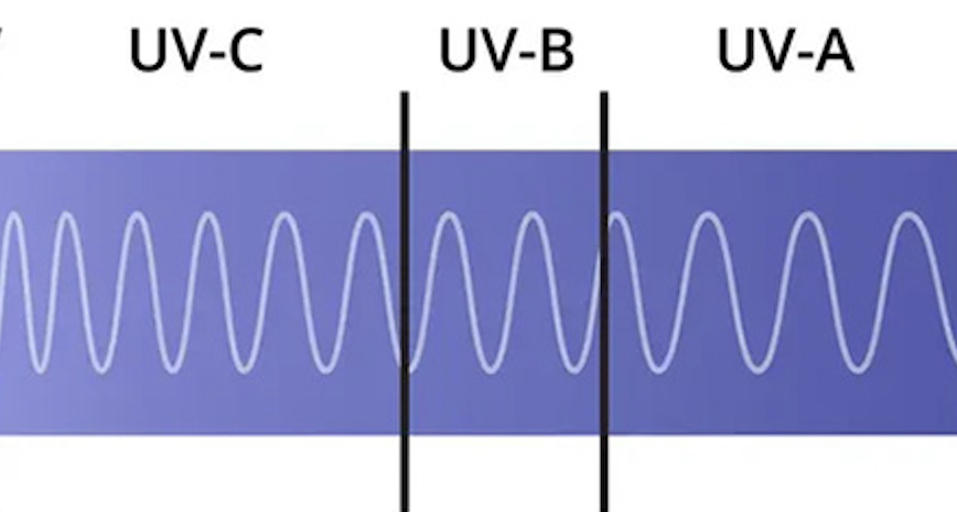
Ozone in the upper layer traps UV light
This ozone causes a temperature rise to 10C
higher, hotter / makin tinggi, makin panas
Stratosphere: UV light trapped in ozone
UVA - least damaging
UVB - causes burns
UVC - most damaging
Regions of the atmosphere - Mesosphere
Extends from 50 to 80 km (50 miles)
Temperature decrease to -75C
Coldest layer of the atmosphere
walopun cold, meteor burns up in this layer
least studied layer of the atmosphere
higher, colder / makin tinggi, makin dingin
Regions of the atmosphere - Thermosphere
Extends from 80 km to 600 km (400 miles)
Contains the ionosphere
a. Layers of oxygen ions
b. Absorbs high-energy radiation from the sun
c. Produces aurorasTemperature increases to 2000C (3600F)
higher, colder / makin tinggi, makin dingin
Ionosphere (contained in the thermosphere)
a. Layers of oxygen ions
b. Absorbs high-energy radiation from the sun
c. Produces auroras
Figure 4.18
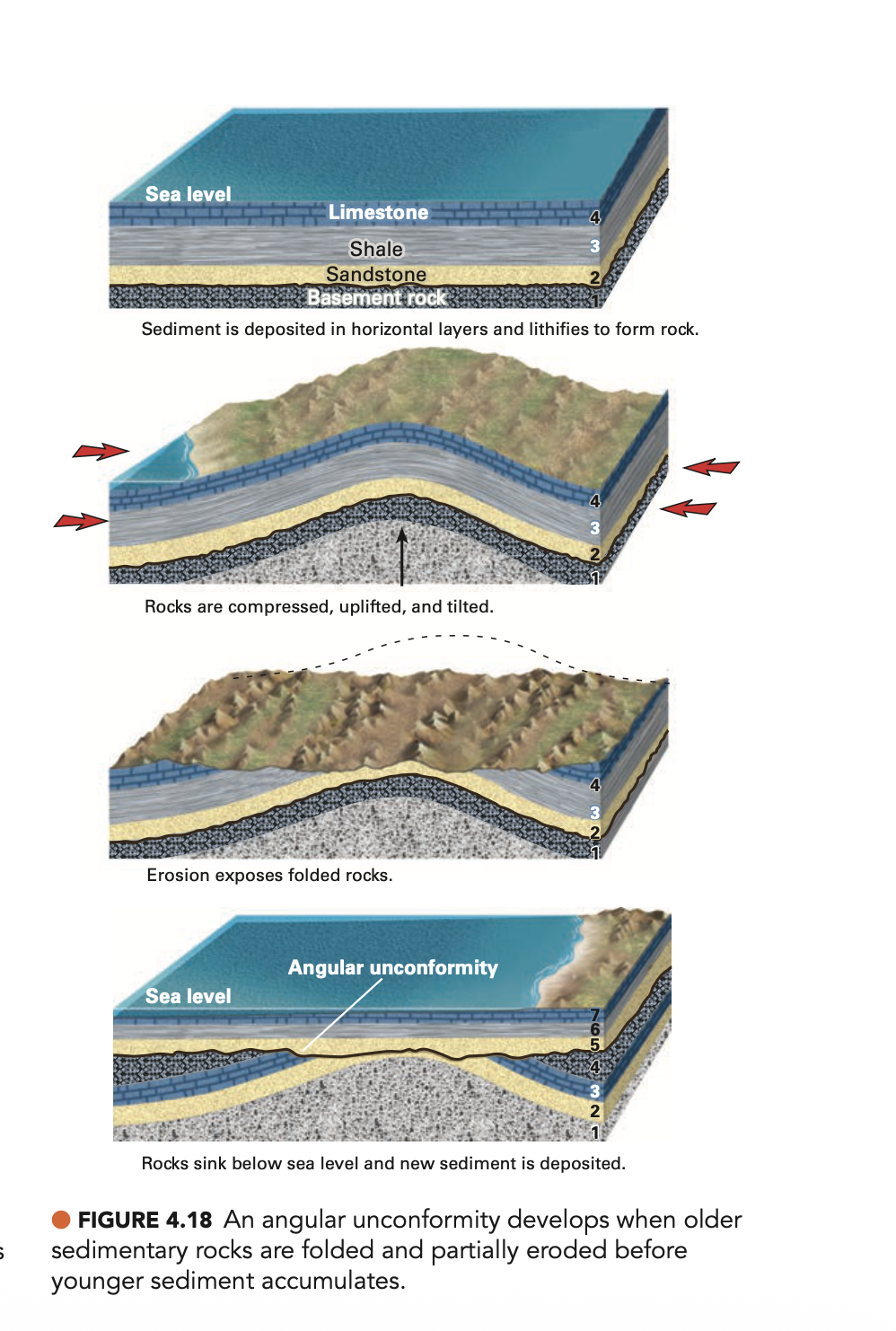
Figure 4.29
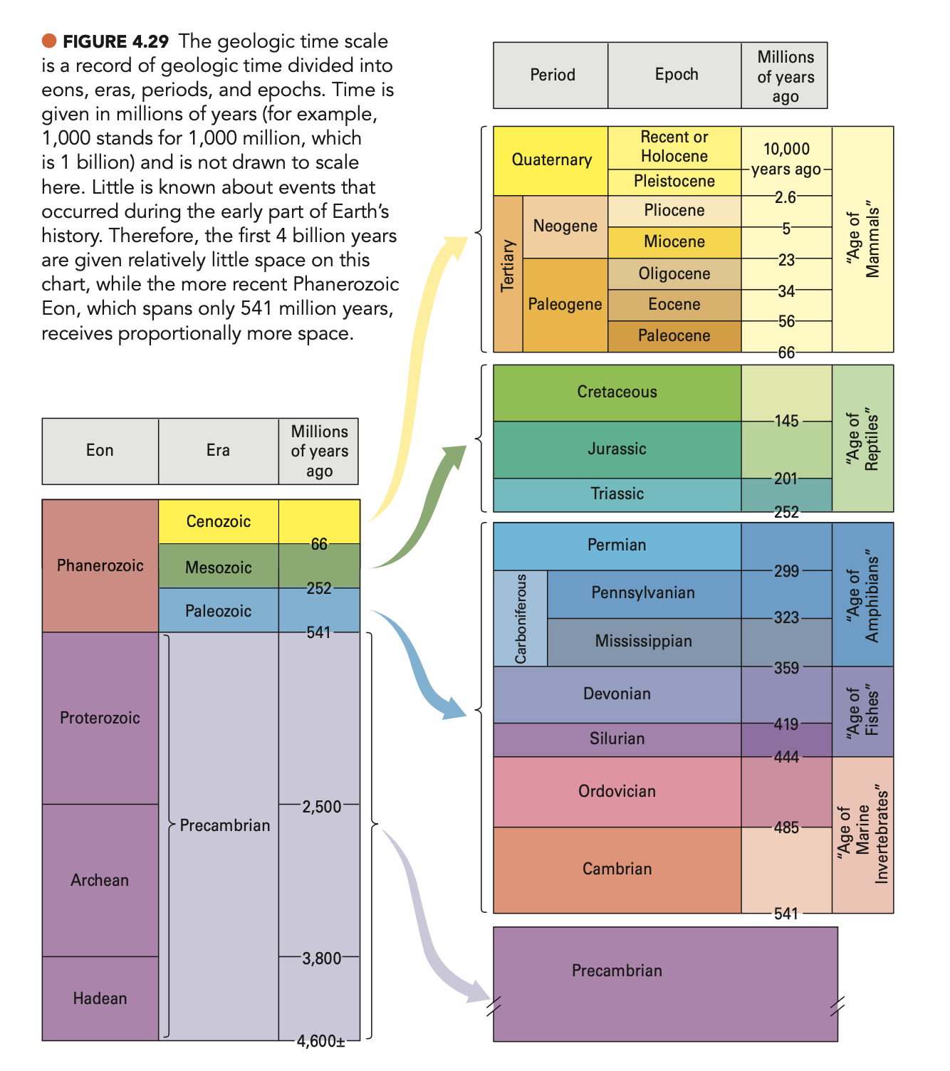
Figure 6.11
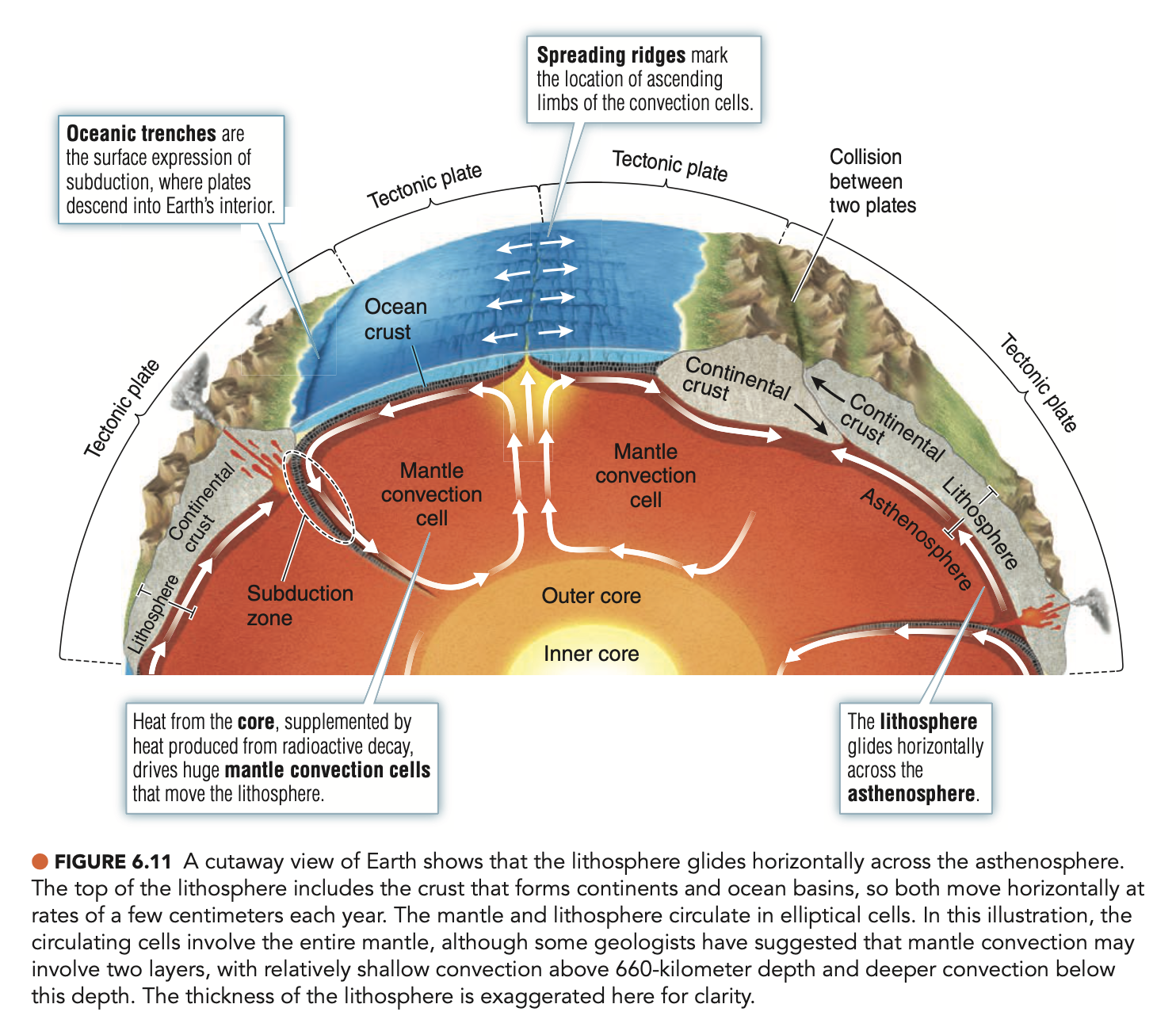
Figure 6.13
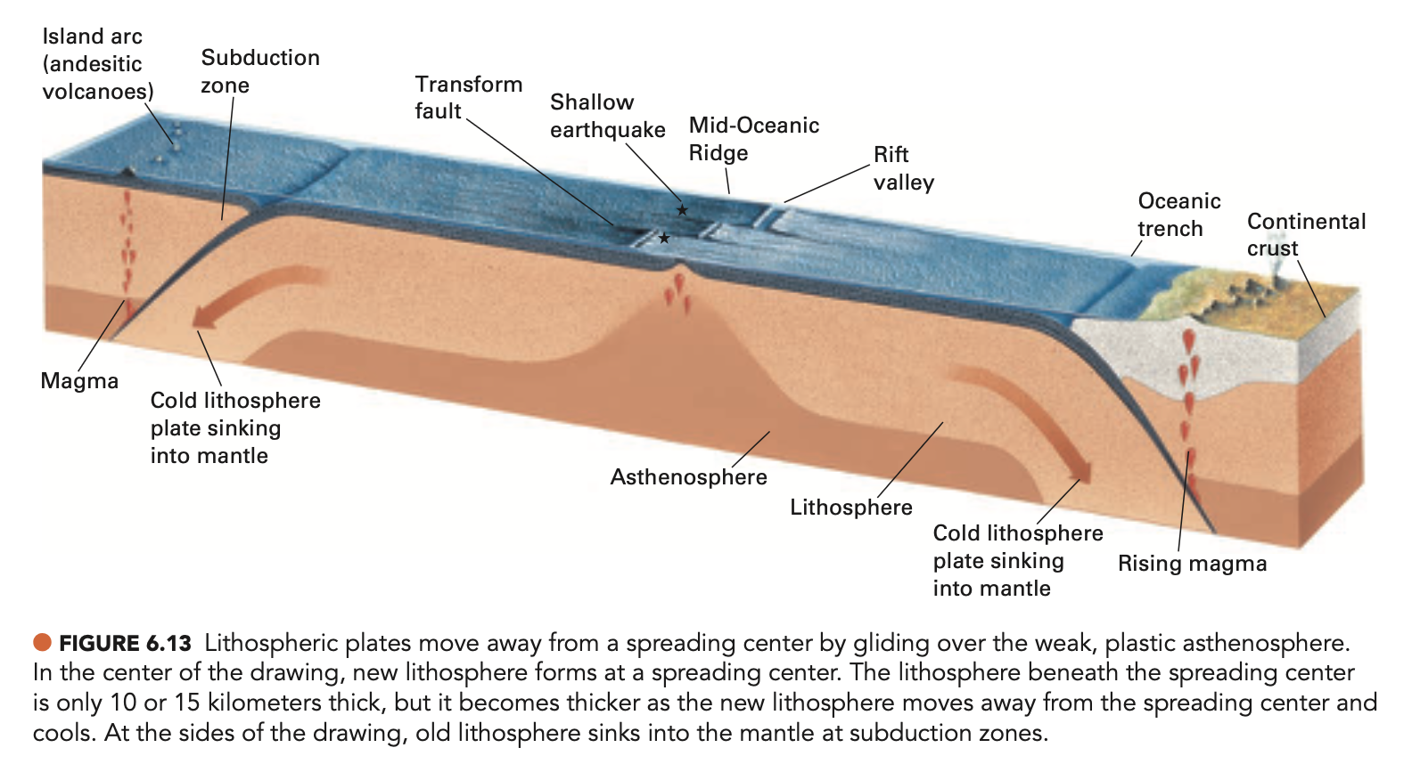
Figure 6.17
Figure 9.11
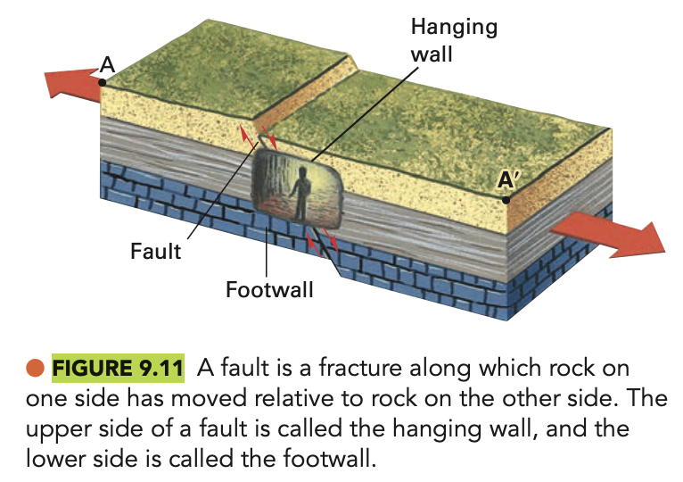
Figure 9.23
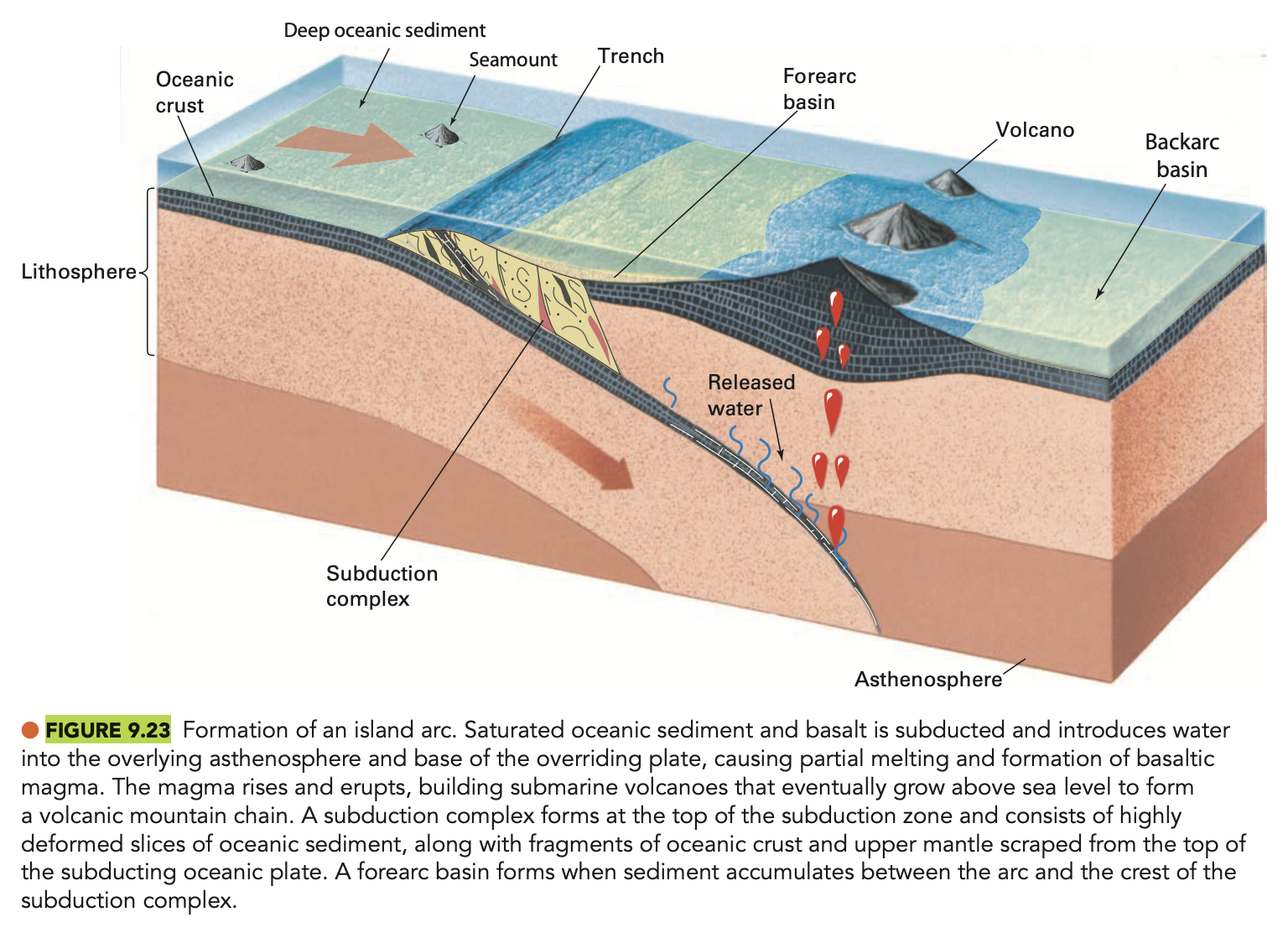
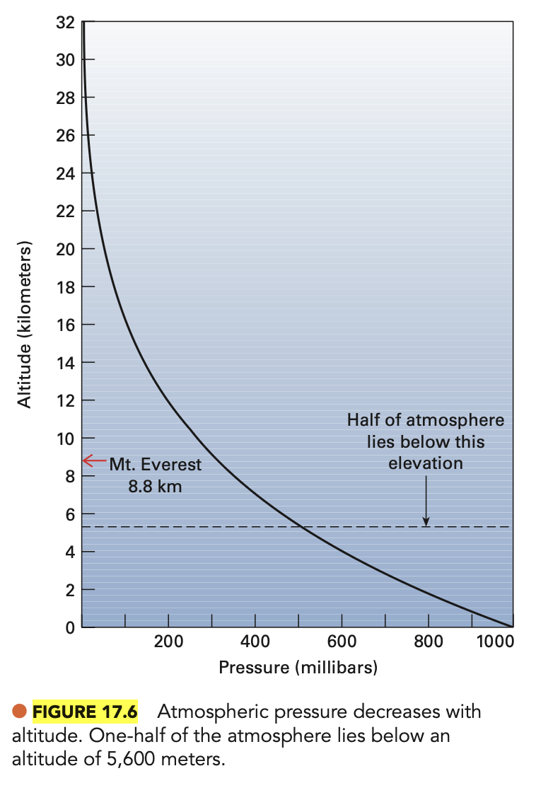
Figure 17.6