Erosion and Weathering / Glaciers
 Call Kai
 Learn
Learn Practice Test
 Spaced Repetition
 Match
Match Flashcards
 Knowt Play
1/167

Earn XP
Description and Tags
mleziva core
Name | Mastery | Learn | Test | Matching | Spaced | Call with Kai | Chat |
|---|
No analytics yet
Send a link to your students to track their progress
168 Terms
What distinguishes erosion from weathering?
Erosion refers to the transportation of weathered rock fragments, while weathering involves only breaking up rock masses
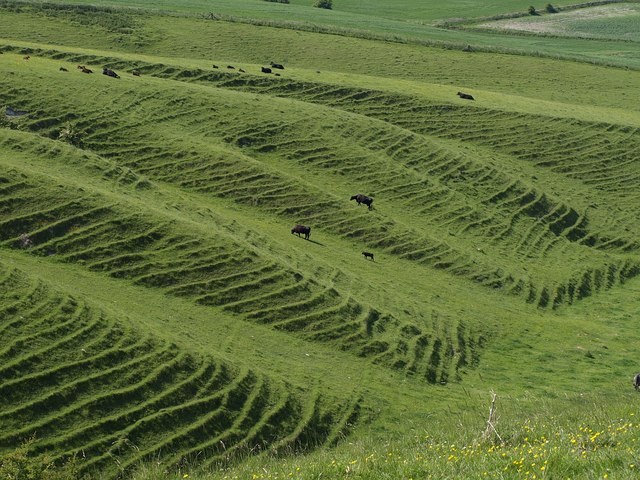
Terracettes
Lines of small ridges on the side of a hill
Formed by soil creep
What does mechanical weathering mean? list 3 types
It involves breaking up rocks into smaller fragments without changing their chemical composition
aka physical weathering
frost action/freeze-thaw
root wedging
exfoliation
Mudflow
high moisture + rapid form of mass wasting
→ Glacial melting adds a massive amount of meltwater to the land. When this water rapidly flows down a slope with soil, it can cause powerful waves of debris + mud → lahars
i.e. lahars can be caused by volcanic eruptions bc glaciers on the volcanoes get melted
Avalanche
Rapid downward fall of snow/ice
Not a type of mass wasting bc mass wasting must be weathered rock material
Caused by excessive snow fall, sudden temp. changes, skiers
Leaching
Process of stripping nutrients from soil where groundwater/rainwater dissolves too many nutrients/minerals out of the soil.
Remedy: add fertilizer in smaller amounts, more often; add organic matter; have a better irrigation system to reduce waterlogging
Granular disintegration/spherification
The physical weathering of the outer surface of a coarse-grained rock so that it becomes rounded
Pervious + give examples
Type of rock that allows water + air to pass through
(Conglomerate, limestone, sandstone)
similar to permeable
Impervious rocks + examples
Type of rock that does not allow water + air to pass through (clay, though clay is porous)
Granite, marble, slate, shale
similar to impermeable
Porous
Rock that is able to hold water
e.g. vesicular external igneous rocks like pumice, scoria
Clay is porous although it is impervious (i.e. it can hold water, but it doesn’t let the water flow through easily)
Imporous
Rock that is unable to hold water
Milanchovitch Cycles
Eccentricity: how much orbit deviates from circle
Precession: wobble/direction of axial tilt
Obliquity: Angle of axial tilt
How do glaciers affect North America in the Ice Ages, present and future?
Ice Age:
Weight of glaciers pushed land down → isostatic depression
(pro)Glacial Lake Missoula → later led to the Scablands
Erosional forces carved out the Great Lakes + other glacial landforms
Abrasion from glaciers scraped off most fertile topsoil from Canadian Shield, but exposed mineral-rich veins
Glacial till deposits, esp those from ground moraine, loess deposits, glacier lake beds, etc, are fertile
Present:
Modern glaciers are rapidly in retreat/melting (Greenland + Antarctica + alpine glaciers)
Immediately after the ice age, some coastal areas were flooded due to eustatic (global) rise in sea level bc of high volume of meltwater
Eventually, the land rose up again after the pressure from glaciers was lifted → isostatic glacial rebound
Future:
Disappearance of some ice caps
water shortages in arid areas
thawed permafrost can cause instability in building foundations
Isostatic rebound/readjustment
the rise of the land after the weight of the glacier is taken off. very slow + isolated to a specific area, not global
this forms a raised beach
Eustatic Sea Level Rise
global rise in sea level after the ice age
What is meant by chemical weathering? list 3 types
It involves the alteration of rock through actual chemical changes in the minerals' composition.
carbonation/solution
oxidation
hydrolysis
hydration (this is both)
plant/animal (potential for both sides)
What is mass wasting? list 5 types
The downhill movement of weathered rock materials through creeping, sliding, slumping, flowing or falling.
Types:
Rock fall
Soil creep
landslide
slump
solifluction
What are the features of loess deposits?
light dun/yellow colour
fine-grained silt (although up to 1/3 can be clay, which is even smaller than silt)
carried into outwash plain by meltwaters as glacier melts/ablates → fluvial transport
wind then carries these powder-like deposits beyond the outwash plain → aeolian transport
when dry, can maintain steep slopes bc of its angular fragments
**it is sorted, but unstratified bc the final depositor is wind, not water → does not form neat layers, but only smaller particles can be picked up causing it to be sorted
What does denudation mean?
the forces that lower the level of the land
i.e. weathering + erosion
What are the three main processes in glacial erosion?
abrasion
plucking
freeze-thaw
What features are associated with alpine glaciation?
horn/pyramidal peaks, tarns, cirques, aretes, u-shaped valley, hanging valleys, ice falls, col, alps?, finger or ribbon lakes, truncated spurs, waterfalls
What’s the difference btwn glacial till and sediments from outwash plains
glacial till is unsorted + big jumbled mix of rocks bc it was carried by solid ice
stratified deposits were sorted by meltwaters and carried into the outwash plains
What defines a drumlin?
a tear-shaped slope of glacial till
indicates direction of movement as glacier deposits
**glacial till = unsorted sediment!!

What constitutes an outwash plain?
This is a flat area formed by morainic sediments deposited by meltwater flowing from a glacial front, producing sorted and stratified sediments.
(sorted = filtered by size of sediment, stratified = the different sizes have been clearly settled in different layers)
What defines a kame?
both continental & alpine
a) a steep mound of deposits formed by meltwater streams
b) a flat-topped mound of deposits formed by meltwater that evens out existing lateral moraines → gradation
all kame is sorted and stratified because it is deposited by meltwater → fluvial transport
What is an erratic in glacial contexts?
This term refers to a solo rock carried and deposited by a glacier, which often differs in size and type from the local bedrock. It is a mix of different kinds of sediment & rock.(unsorted)
What does neve refer to?
It describes the granular snow that compacts and transforms into glacial ice over time, found in the upper regions of a glacier.
What is abrasion in the context of glaciers?
type of physical erosion
scraping or grinding of a bedrock by an ice sheet
example of a feature produced by this action is striations
What is meant by plucking in glacial contexts?
type of physical erosion
This process refers to the removal of pieces of bedrock by ice, leading to the formation of features such as U-shaped valleys.
happens bc the rock freezes onto the ice
What are striations?
These are scratch marks or grooves found on bedrock, created by the abrasional action of debris embedded in the glacier's base.
What are ribbon lakes?
both continental and alpine
They are long, narrow lakes that were created by glaciers cutting through ground that is composed of bands of soft and hard rock outcrops. the soft rock gets eroded into long narrow depressions that turn into lakes after the glacier melts. on a map these often look like claws
→ the hard bedrock is known as a rock bar
can also be formed by damming behind a reccesional or temrinal moraine

What is roche moutonnee?
both alpine & continental
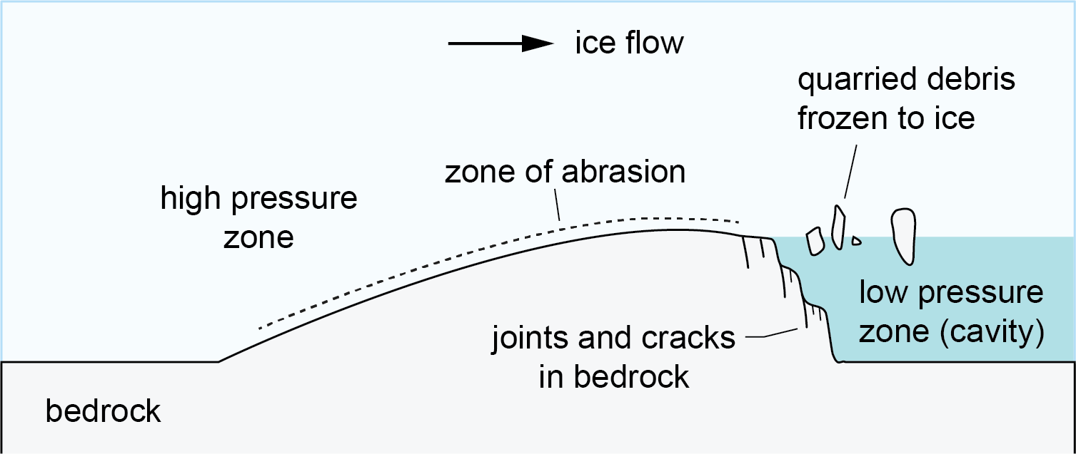
a sloped outcrop of bedrock that is smooth on the end that the ice flow came from (upstream), and rough on the end the ice flow left (downstream)
upstream end: higher pressure caused abrasion which grinded the bedrock smooth + created striations
downstream end: lower pressure caused meltwater to freeze → freeze-thaw → plucking
occurs bc glacier flows over a bedrock
What is a Graduational Force?
A force that levels out rock structures.
Why do Ice Ages occur?
a) volcanic eruptions lower global avg temp bc the ash prevents UV rays from getting into the earth
b) variation in solar energy emitted from Sun
c) Milankovitch Cycles:
Eccentricity: Variation in orbit shape (spherical vs elliptical)
Tilt: Variations in angle of earth’s tilt
Precession: Variation in wobble, aka direction of tilt
d) reduction in CO2 on Earth
What is the difference between alpine and continental glaciation?
alpine is formed at high altitudes; continental is widespread and occurs across over a large land mass
Where do alpine glaciers tend to form?
on fold mountains near the coast (high precipitation) so that snow can accumulate enough to squash into ice
onshore winds bring wind directly to the mountains
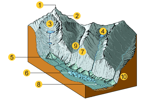
List all the glacial landforms in this photo + the type of glacier that produces them.
1 is a Pyramidal Peak; 2 is an Arête; 3 is a Cirque; 4 is a Tarn; 5 is an Alluvial Fan; 6 is a Ribbon Lake; 7 is a Truncated Spur; 8 is a Misfit Stream; 9 is a Hanging Valley; 10 is a 'U' Shaped Valley
alpine glacier (except misfit stream is more continental)
Cirque
a deep spherical depression in the side of a mountain formed by a glacier.
As the glacier builds in the depression, freeze-thaw causes rocks from the outer layer of the mountain face to break off and become embedded in the glacier
As the weight of the glacier causes it to slide around, more rocks get integrated and plucked
Finally, the rocks in the glacier deepen and widen the depression through abrasion.
Tarn
if the cirque becomes full of water, this lake is called a ___.
Horn/mountain peak
sharp top of a mountain formed by multiple cirques cutting out the sides
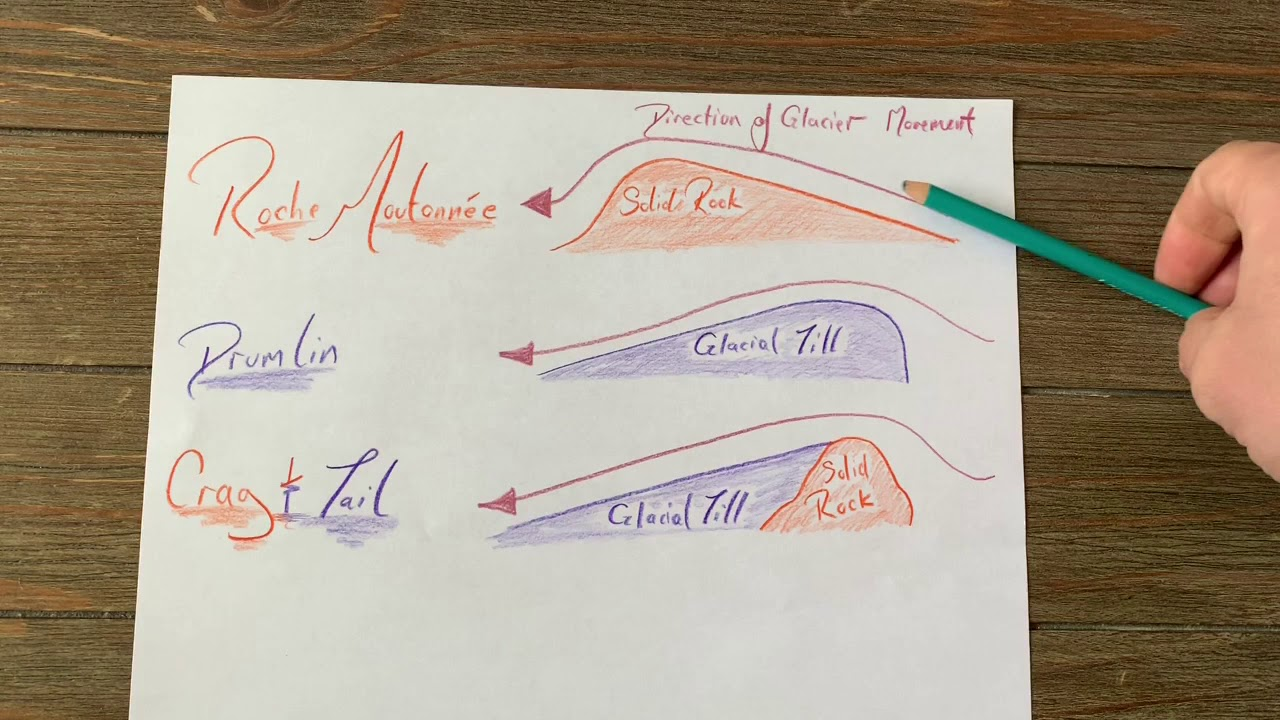
What’s the difference between a drumlin and a roche mountonee?
glacial till in drumlins vs bedrock in roche moutonee
direction of skew as glacier approaches
roche mountonee
approaches from a sloped, smooth side (abrasion) and ends on a jagged, steeper side (plucking)
glacier flows over bedrock
drumlin
approaches from the steep side, leaves on the sloped tail → caused by change in upstream/downstream movement
glacier flows over glacial till
spillway
valley formed by meltwater (continental glaciation)
usually wide and shallow bc meltwaters carry a LOT of sediment
misfit streams
both continental + alpine
streams that occupy spillways formed by meltwater from glaciers. these streams are so much smaller than the og glacial river that formed the spillway that they look out of place.
can also occupy u-shaped valleys
eskers
long winding ‘snakes’ of sorted deposits left by meltwater
super for road building bc of its permeability + porosity
its skinny bc its formed by substreams in, on or beside the glacier
sorted and layered bc fluvial transport
glacial ponding
body of water that forms from leftover glacial meltwater that is unable to flow away
Which glacial features are both alpine and continental?
For sure: striations, erratics, crevasses, moraines, glacial till,
Maybe: eskers, drumlins, roche moutonnee, ribbon lakes, kame, misfit streams
Difference between striations and crevasse
Striation: a scratch left on the rock below the glacier
Crevasse: a crack in the glacier itself
How have glaciers benefited North America?
Canadian Shield, abrasion exposed valuable minerals to the surface (although it also scraped away most fertile topsoil)
Post-ice age isostatic rebound → new land resurfaced
Fjords used as sheltered harbours
Tourism
Great Lakes
The Rockies
Skiiing & snowboarding on mountains
mountain lakes (tarns)
Energy
Hydroelectric power
Great Lakes
Waterfalls from hanging valleys
Transport
Great Lakes
St. Lawrence River
The Rockies
Hudson-Mohawk Gap - a glacial-cut channel that connects to New York
Freshwater/drinking water
Great Lakes
St. Lawrence River
Fertile land:
Fertile soil deposits in Prairies + boulder clay plains around Canadian Shield (from glacial till)
Good drainage + quality soil + gentle rolling hills from glacial till South Ontario
Build-in fertilizer in till from limestone-rich bedrock
glacial lake beds are fertile
Transhumance → migration of herds/flocks
Ridges with pastures on the sides of mountains are good for raising cattle during warmer seasons
Ablation
loss of material from a glacier
How do glaciers move? Describe the process.
Glacial creep. The weight of the glacier causes slow movement, especially near the center of the glacier where it is the thickest → ice crystals inside the glacier shift and creep from the pressure of its own weight
Basal sliding. Internal streams (meltwater) + warmth of earth along the bottom of the glacier causes fast sliding. (less common)
accumulation
addition of material to a glacier
How do you know if a glacier will retreat or advance?
accumulation > ablation → advance
accumulation < ablation → retreat
accumulation = ablation → net movement zero, internal streams exist
col
a cirque that separates an otherwise continuous mountain ridge
arete
sharp ridge that separates cirques
How are cirques formed?
Snow fills a depression on a mountain, compacts into neve, later into ice → forms a glacier
freeze thaw on mountain expands and contracts the rock, causing fragments to break off
abrasion as glacier moves around the cirque in a circular motion (bc its so heavy)
plucking deepens + widens the cirque
Glacier grows and continues to expand the depression, until it is too heavy to stay on the side of the mountain and starts to creep out.
The hollow left behind is a cirque.
alluvial fan
special formation of deposit formed when a high-pressure, fast stream suddenly enters a flat, open plain and loses velocity.
creates a large ‘fan’ of alluvial deposits
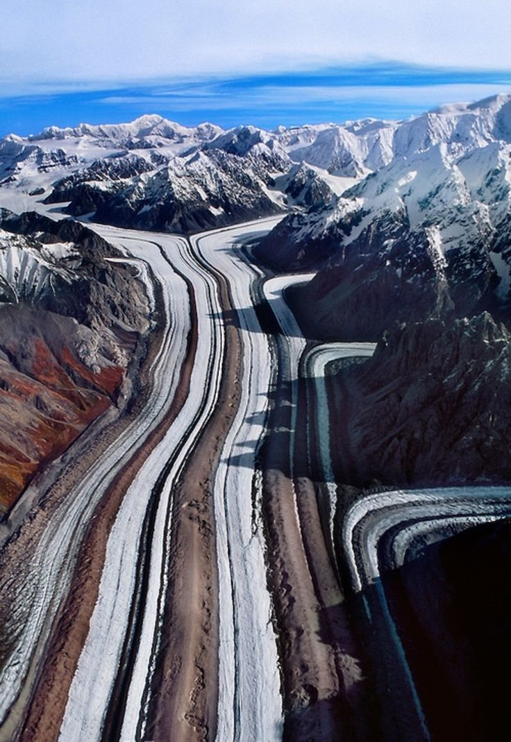
find 8+ glacial features (click on photo to zoom)
medial moraine (ii) truncated spur (iii) hanging valley (iv) cirque (v) pyramidal peak (vi) arête (vii) snow field (viii) lateral moraine.
What are the key features produced by continental glaciation?
smoothed/rounded hills
hollows, which form lakes (in soft outcrop of rock)
roche moutonnée (harder outcrop of rock)
entirely bedrock
craig and tail (e.g. volcanic rocks)
part bedrock, part glacial till
drumlin
entirely glacial till
moraine
terminal, lateral, medial, ground moraine
kettle lakes
outwash plains
erratics
potholes?
alp
a nook on the side of a valley glacier that provides fertile grass for grazing cattle during the summer
during the winter, cattle get moved to the pastures at the bottom of the valley
transhumance
its below the snow line but above the valley line
Switzerland, Norway, other mountainous countries
transhumance
movement of cattle from higher glacial pastures to lower pastures at the bottom of a glaciated valley, and vice versa
these valleys have rich pastures for grazing
ice fall vs crevasse
crevasse:
both alpine & continental
both meltwater & solid ice
→ bc meltwater widens the crack after it is formed in the ice
Definition: a deep crack in a glacier caused by stress, a change in direction, steepness of ground, or entrance into a wider valley
ice fall:
looks like a frozen waterfall; glacier has many crevasses and cracks all over in this area bc the glacier had to squish into a narrower channel or experience a change in steepness
which part of the glacier moves the fastest, and why?
center of the glacier
sides experience more friction
basal sliding:
immense pressure lowers melting point of ice → more meltwater at bottom of glacier → faster movement in center
glacier creep:
ice crystals melt and refreeze in a cycle that causes it to crawl down a slope
exacerbated by higher pressure + temp
freeze thaw weathering
physical
water enters cracks in rock, freezes, expands → widens cracks
if water melts and refreezes, over time this can split the rock into pieces
forms angular fragments which accumulate at the bottom of a hill → talus/scree
exfoliation/spheroidal weathering
physical
most common in arid areas w/ high temperature fluctuation (aka hot deserts)
rapid swing in temp causes different minerals in the rock to contract + expand at different rates → outer layer separates from the inside
over time, layers of rock peel off
Related to spheroidal weathering bc:
water (rain) erodes rock into a round shape over time by peeling off the weakened outer layers
bc water rounds off any surface features and smooths the rock out
root action/root wedging
physical weathering:
vegetation grows in the cracks of a rock → widens the crack as the plant grows
eg: tree roots, lichens, mosses, bush roots
**NOTE: vegetation could also reduce soil erosion because it regulates the temperature + binds soil together → both positives and negatives with plants on rocks
carbonation or solution weathering
chemical weathering
limestone most common
slightly acidic rain is made when CO2 dissolves into rainwater (H2CO3 or carbonic acid)
the carbonic acid reacts with limestone to produce a new compound that is soluble in water → easily eroded
affects joints & bedding planes in the rock
causes karst topography
caverns, underground rivers, sinkholes, poljes, uvalas, etc
oxidation weathering
chemical
Iron → rust → forms red coloured rocks
rusted rocks more susceptible to erosion
hydrolysis weathering
chemical
common with granite (anything with feldspar mineral)
slightly acidic rainwater reacts with feldspar
creates clay (softer, smaller granules, susceptible to physical erosion)
hydration weathering
combination of mechanical & chemical weathering
mainly affects rocks with salt minerals
water seeps into rocks and attaches to anhydrous salt minerals (mr yoo’s lab!!)
increases pressure + causes swelling
→ internal stress, fractures, physical breakdown of rock
What is the typical rule for which type of weathering affects the dif types of rocks?
sedimentary → physical/mechanical
igneous or metamorphic → chemical
limestone exception!
which type of climate is chemical weathering most commonly in?
warm + humid bc chemical reactions occur faster at higher temps & moisture levels
karst topography + features created by it
a landscape formed by the dissolution of soluble rock through chemical weathering
usually limestone
creates underground rivers, sinkholes, caverns
stalactites
hang down from ceiling of cave
stalagmites
protrude upwards from ground
pillar
mineral deposit that connects the floor and the ceiling in a cavern
sinkhole
forms when a cave/cavern reaches the surface
aka doline
uvala
a larger depression
polijes
a collapsed cave
hum
a small, steep mound that is formed in the final stages of karst topography. it was able to resist chemical weathering bc it is a piece of sturdy bedrock
*common in the Rockies

what affects the severity of mass wasting?
angle of slope of hill
gravity
water presence
human factors: deforestation, mining, farming, urban development
aquifer
underground layer of permeable rocks that store groundwater (water from rain + precipitation over the years that collects underground)
must be above a layer of impermeable rock
extremely good quality source of water
source of wells + springs
clint
flat topped ridge in limestone after carbonation
grike
deep + narrow groove in limestone caused by carbonation
plant/animal chemical weathering
plants absorb minerals from soil
bacteria break down minerals when in water
decaying plants produce organic acids → breaks down minerals further
**chemical weathering most common in humid + warm climates
grike vs clint vs joint
clint: flat topped ridge in limestone after carbonation
grike: deep + narrow groove in limestone caused by carbonation
joint: crack in the rock where the rain enters (dif. from faults bc joints are stationary wheras faults always move)
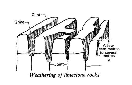
what is a joint and how is it created
crack in the rock (dif. from faults bc joints are stationary wheras faults always move)
created by tectonic processes + release of pressure (exfoliation) + thermal contraction (basaltic columns)
which human activities affect mass wasting, and why?
deforestation
mining
farming
urbanization (construction of towns)
all of these increase the instability in slopes.
how can humans reduce their effect on mass wasting?
deforestation:
if we cut trees, replant them
sustainable usage of natural resources
settlement:
build on solid foundations/bedrock → not limestone!!!!
don’t build on steep slopes
proper drainage systems to not oversaturate our soil
terraces (aka stairs) instead of flat slopes may help reduce gravity’s weathering of soil
mining:
if we close a mine, restore it back to the way that it was as closely as possible
remove heavy metals + pollutants from mine water before reintroducing into the ecosystem
farming:
improve drainage systems to redirect excess water away from the soil
replant trees or shrubs with deep roots on slopes to hold the soil together
landslide
medium moisture, fast form of mass wasting
→ debris falls in planear fashion (completely straight)
→ more moisture than rock fall
→ en masse
rock fall
fast + dry type of mass wasting
→ weathering causes rock fragments to fall off the side of a cliff and accumulate in piles (taluses/screes)
→ commonly caused by freeze thaw
slump
forms GULLIES
a slow speed, medium-humidity type of mass wasting
→ caused by heavy rain
→ water reduces friction btwn soil particles + adds weight to soil
→ debris falls in a curved path
soil creep
slow and dry type of mass wasting
→ causes leaning in the objects/land above (trees, buildings, infrastructure)
→ creates terracettes too
→ less than 1-2 cm/yr
solifluction
slow + high moisture type of mass wasting
slow movement of water-saturated soil down a non-permeable surface
eg. permafrost in Arctic tundra
forms lobes

another word for sinkhole
doline
spring
body of water fed by an underground aquifer that has at least 1 end where the water table is exposed at the surface and that emits a constant flow of water outside
artesian well
high → low pressure gradient of water on a slope naturally pushes water up a tube to allow for constant water flow
the aquifer must be a shallow syncline with impermeable rock underneath and above, and one or more ends of permeable rock exposed at the surface to allow water to enter
→ called an artesian basin
permeable rock
rock that allows water to pass through its joints
very similar to pervious except i think pervious rocks allow water to pass through their pores??
pretty interchangable imo
impervious rock
rock that is non-permeable; forms bottom and top of an aquifer
i.e. it doesn’t allow water or air to flow through
why is groundwater important for humans? 4 reasons
springs + wells decide settlement locations, especially in arid areas like deserts
provide water for cattle
has a role in irrigation
provides large source of drinkable water
what is a gully
a deep channel formed by slumps or water erosion
→ usually on hillsides with low vegetation so that the water can erode the hill without roots holding the soil together

terracette
formed by soil creep
looks like mini-steps/ridges on a hill

stalactite
deposits of mineral that build up into a structure that hangs down from the ceiling of a cave
stalagmite
deposits of mineral that build up into a structure that protrudes up from the floor of a cave
pillar
deposits of mineral (calcium carbonate) that build up into a structure that connects the floor of a cave to the ceiling
caused by karst topography
hum
small hills left in a cave by karst topography after the cave has gone
poljes
caused by collapse of a cave due to karst topography
→ different from sinkholes bc these are much wider and flat-bottomed. they also have extremely steep walls
uvala
a large depression caused by karst topography
→ usually the combination of multiple sinkholes/dolines