AP Human Geography Unit 4 exam
1/53
There's no tags or description
Looks like no tags are added yet.
Name | Mastery | Learn | Test | Matching | Spaced |
|---|
No study sessions yet.
54 Terms
A primate city
A good example of a centripetal force in political geography is
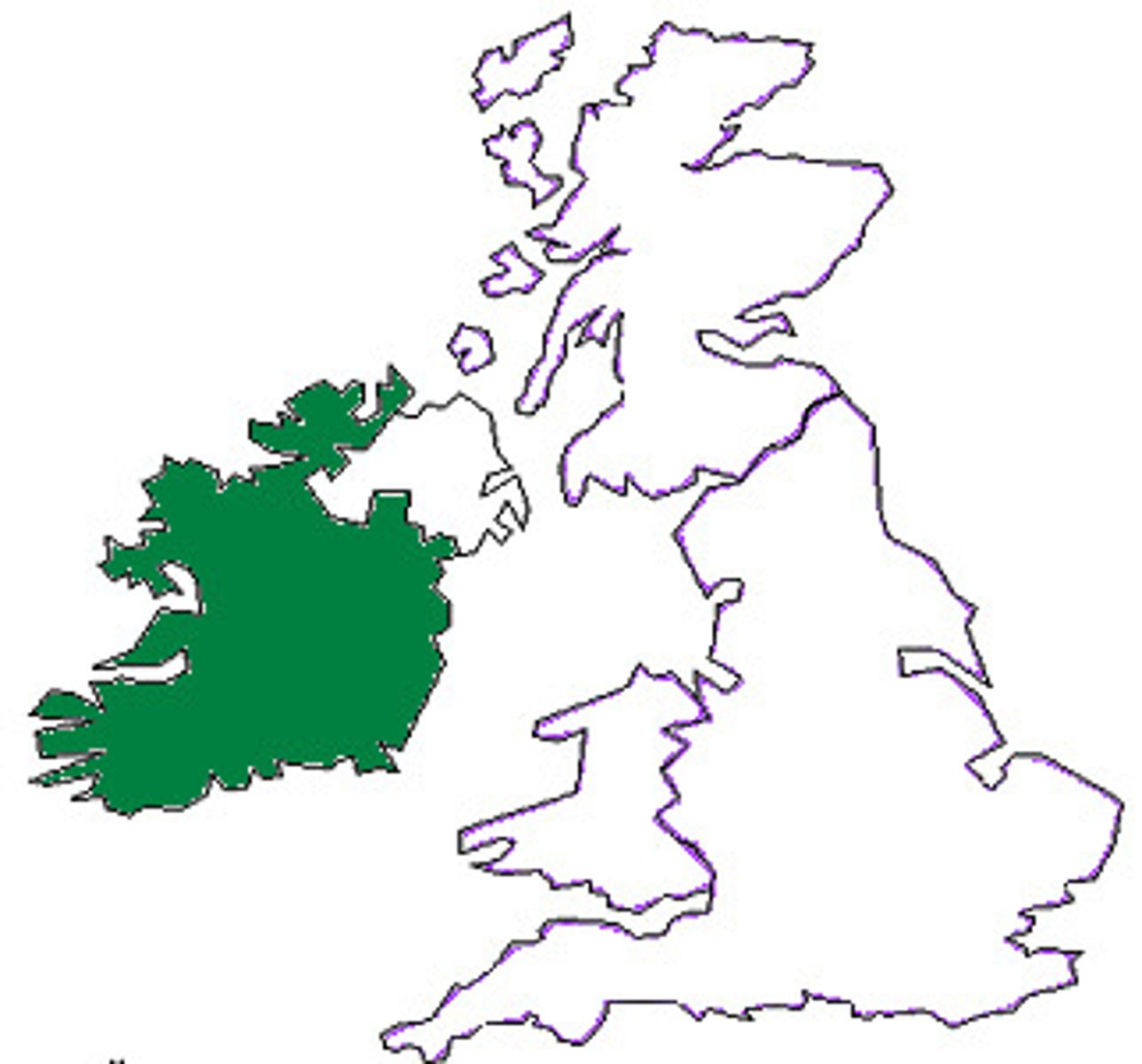
It is physically separate from the rest of the United Kingdom, a multinational state.
Based on the map, which of the following can be identified as a true statement about Northern Ireland?
Japan
At some point in their recent history, all of the following countries became divided into two political entities as a result of cultural or ideological conflict EXCEPT
Catalonia is well developed economically compared to other regions in Spain.
Which of the following best explains why the region of Catalonia in Spain could be a viable country?
Geometric with straight lines, disregarding physical features or tribal cultural different of the area
The Berlin Conference established the borders of North African countries including Egypt, Libya, and Sudan. The landscape of these countries influenced the types of boundaries imposed by the European colonial powers. Which of the following boundary types best explains the influence of landscape on the political borders of the North African region?
bodies of water
Boundaries based on the median-line principle are generally associated with
a relict boundary
The former international border between East Germany and West Germany is best described as
Centripetal forces at both the local scale and the national scale may lead to increased cultural colesion
Which of the following correctly compares the impact of centripetal forces at the local scale with the impact of centripetal forces at the national scale?
A large land area and multiple ethnic groups
Which of the following describes typical characteristics of federal states?
The claims to the Spratly Islands by both the Philippines and Malaysia overlap due to exclusive economic zones up to 200 nautical miles from their coasts.
Which of the following best explains how the United Nations Convention on the Law of the Sea (UNCLOS) influences claims to the islands by both
countries?
Netherlands-Belgium
Crossing which of the following borders requires few, if any, formalities and thus encourages the free flow of people and products?
A state has a strong central government with no power given to regions
Which of the following describes a unitary form of governance?
There is an economic aspect to the Catalan independence movement, while the Quebecois focus mainly on cultural differences
Which of the following is an accurate comparison of devolutionary movements in Spain and Canada?
Nation-state
Historically, Iceland had only one period of human migration. The country has never been invaded and possesses a common culture and language. As a result, Iceland is regarded as a good example of which of the following concepts?
Global communications technology may bring in new ideas that act has centrifugal forces, whereas state-controlled media is utilized as a centripetal force to present a common message.
Which of the following compares the impact of increased global communications technology to the impact of state-controlled media?
French language and culture act as a centrifugal force in Canada because independence movements in Quebec have attempted to secede the province from Canada.
Which of the following best explains the effect of French language and culture on the federal state of Canada's political power?
These areas show where indigenous peoples have a limited amount of self-government at a national scale.
Which of the following best explains the governance of the shaded areas shown on the map.
Canada created the province of Nunavut to provide greater autonomy of the First Nations.
Which of the following describes an example of a consequent boundary.
Supranational
Which of the following is the correct organizational scale for the Economic Community of West African States (ECOWAS)?
Ethnicity and religion lead to devolutionary pressures in the country by politically dividing regions.
Based on the data in the table, which of the following is a possible impact of ethnic and religious diversity in Iraq?
Japan
Which of the following best represents the concept of the nation-state in its internal cultural-political makeup and spatial organization?
Russia
Which of the following best illustrates the geographical concept of the nation-state?
A multinational trade zone in which most tariffs have been eliminated
Which of the following best describes the North American Free Trade Agreement (NAFTA) between the United States, Canada, and Mexico?
They all claim the right to extract natural resources out to the edge of the continental shelf, beyond their exclusive economic zones
What is the source of dispute between Canada, Russia, Norway, Denmark and the United States over political boundaries in the Arctic Ocean and ownership of the North Pole?
claim national economic jurisdiction over 200 nautical miles of water extending from its coast
United Nations recognition of a state's "exclusive economic zone" allows the state to
Admittance into a supranational organization such as the European Union
Which of the following events could be a threat to a state's sovereignty at the national scale, while holding a region together at the global scale?
gerrymandering
The shape of North Carolina's Twelfth Congressional District, shown above, is most likely the result of
twelve-nautical mile territorial sea zone
The Provisions of the United Nations Conference on the Law of the Sea give coastal countries navigational and economic sovereignty over which of the following zones?
Irredentism
The map above shows the countries in Africa where private investors and foreign governments have leased farmland for large-scale commercial farming. Usually much of the food produced is bound for wealthier nations . This practice is an example of -
supranational organizations
The European Union, the Arab League, and the United Nations are all examples of
Recognize the territorial rights of indigenous people in the area
The Canadian government created the new territory of Nunavut in order to
The Kurdish people, seeking a state of their own with a majority Kurdish population, might secede from or rebel against the states labeled on the map.
Based on the information in the map, what is the most likely outcome of the possible establishment of an independent Kurdistan for the Kurdish people?
nation-states
Owing to their localized geography or their locations on islands or peninsulas, many small political entities such as those labeled on the political map of the world can be identified as
The geometric boundary between the United States and Canada
Which of the following is an example of a superimposed boundary?
Relict Boundary
The Berlin Wall fell in 1989, but people in the former East and West Germany still feel its influence. Geographers would say that where the wall once stood now acts as a...
Redrawn every ten years
The boundaries of congressional districts of the United States are
Semiautonomous regions
Which of the following terms identifies the type of regions shown in the dark gray-shaded areas on the map?
Even in areas with a Kurdish majority population, are landlocked and therefore dependent on good relationships with their neighbors in order to access trade and prosper economically
Based on the map, which of the following best explains the implications of physical geography as the Kurds continue to struggle for an independent state in their
ethnic homeland?
National
In the United States House of Representatives there are a fixed number of 435 seats divided among the states based upon each state's relative population size. Changes in the number of representatives, as shown on the map, affect politics at which of the following scales?
European colonial powers in the late nineteenth century
Most of Africa's political boundaries were originally drawn by
it created centripetal forces at both local and national scales
Nunavut in Canada is a semiautonomous region that allows an indigenous group within Canada to maintain their own culture and local government, reducing the threat of fragmentation. Which of the following best compares the impact of the creation of Nunavu at both local and national scales?
Fragmented
Indonesia is an example of which of the following types of states?
Korea and Vietnam experienced conflict due to a dispute between global powers.
Which of the following explains why Korea and Vietnam were viewed as shatterbelts during the cold war?
Shatterbelt
Which of the following terms refers to an area of instability located between regions with opposing political and cultural values?
Gerrymandering
Which of the following is the name for political redistricting that produces unusually shaped districts to create a political advantage?
a common language
Which of the following is NOT part of the definition of a state?
Apartheid
Which of the following is South Africa's former state-sanctioned policy of segregating the races?
Yugoslavia
Which of the following is an example of Balkanization?
The European Union
Which of the following is an example of a supranational organization with the main mission of increasing economic integration?
eastern europe
Which of the following is an example of a shatterbelt region?
Kurds
Which of the following groups represents a nation without a state?
Germany
Which of the following countries did NOT have a significant, long-lasting colonial presence in Africa after 1920 ?
Empire, nation-state, province, county
Which of the correctly lists the usual hierarchy of political-administrative units in order from largest to smallest?
Low population growth
Which of the following characteristics is currently shared by Switzerland, Canada, and New Zealand?