FAA Part 107 Drone Test (Practice Questions)
1/108
There's no tags or description
Looks like no tags are added yet.
Name | Mastery | Learn | Test | Matching | Spaced |
|---|
No study sessions yet.
109 Terms
Registration requirements for small unmanned aircraft systems. Under what condition would a small UA not have to be registered before it is operated in the United States?
When the aircraft weighs less than .55 pounds on takeoff, including everything that is on-board or attached to the aircraft.
Registration requirements for small unmanned aircraft systems. According to 14 CFR part 48, when must a person register a small UA with the Federal Aviation Administration?
The owner is less than 13 years of age.
[48.25 says, "(b) A small unmanned aircraft must be registered by its owner using the legal name of its owner, unless the owner is less than 13 years of age. If the owner is less than 13 years of age, then the small unmanned aircraft must be registered by a person who is at least 13 years of age." Keep in mind that they are trying to make you know Part 48. There are other answers as to why a person could not register via Part 47 such as being a foreign citizen.]
A small UA must be operated in a manner which...
does not endanger the life or property of another.
After having dinner and wine, your client asks you to go outside to demonstrate the small UAs capabilities. You must..
not operate a small UA within 8 hours of consuming any alcoholic beverage.
Daylight operation. According to 14 CFR part 107, what is required to operate a small UA within 30 minutes after official sunset?
Use of anti-collision lights.
During a flight of your small UA, you observe a hot air balloon entering the area. You should
yield the right-of-way to the hot air balloon.
[107.37 says, "(a) Each small unmanned aircraft must yield the right of way to all aircraft, airborne vehicles, and launch and reentry vehicles. Yielding the right of way means that the small unmanned aircraft must give way to the aircraft or vehicle and may not pass over, under, or ahead of it unless well clear."]
Prior authorization required for operation in certain airspace. According to 14 CFR part 107, how may a remote pilot operate an unmanned aircraft in class C airspace?
The remote pilot must have prior authorization from the Air Traffic Control (ATC) facility having jurisdiction over that airspace.
[You are going to have to have an airspace waiver. §107.41 says, "No person may operate a small unmanned aircraft in Class B, Class C, or Class D airspace or within the lateral boundaries of the surface area of Class E airspace designated for an airport unless that person has prior authorization from Air Traffic Control (ATC)." The FAA is handling those authorizations via a waiver process currently. Let me know if you need one! ]
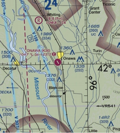
(Refer to FAA-CT-8080-2H, Figure 78.) You have been hired to use your small UAS to inspect the railroad tracks from Blencoe (SE of Sioux City) to Onawa. Will ATC authorization be required?
No, your entire flight is in Class G airspace.
Preflight familiarization, inspection, and actions for aircraft operations. According to 14 CFR part 107, who is responsible for determining the performance of a small unmanned aircraft?
Remote pilot-in-command.
[See 107.19. Learn the short version of this regulation. “If anything goes wrong, it is most likely the PIC’s fault.” You shouldn’t let anyone force you into flying somewhere or doing something you feel is unsafe. You are getting the whacking if anything goes wrong, not them.]
According to 14 CFR part 107, what is the maximum groundspeed for a small UA?
A) 87 knots. [87 knots is 100 MPH]
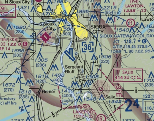
(Refer to FAA-CT-8080-2H, Figure 78.) You have been contracted to inspect towers located approximately 4NM southwest of the Sioux Gateway (SUX) airport operating an unmanned aircraft. What is the maximum altitude above ground level (AGL) that you are authorized to operate over the top of the towers?
C) 802 feet AGL.
[This is Class D airspace and you would have to get a COA to operate here. I have NEVER seen one been given out for over 400ft. Yes, you could technically get a 400ft+ waiver and a COA to exercise it or get a special COA to operate within 400ft of a structure but it is extremely rare. Technically, under 107, if you are within 400ft of the structure you can go up to 400ft above the top of it (402 AGL is what the map says) which makes it 802 AGL.]
Upon request by the FAA, the remote pilot-in-command must provide
a remote pilot certificate with a small UAS rating.
[107.7 Inspection, testing, and demonstration of compliance. (a) A remote pilot in command, owner, or person manipulating the flight controls of a small unmanned aircraft system must, upon request, make available to the Administrator: (1) The remote pilot certificate with a small UAS rating[.]"]
The refusal of a remote PIC to submit to a blood alcohol test when requested by a law enforcement officer
is grounds for suspension of revocation of their remote pilot certificate
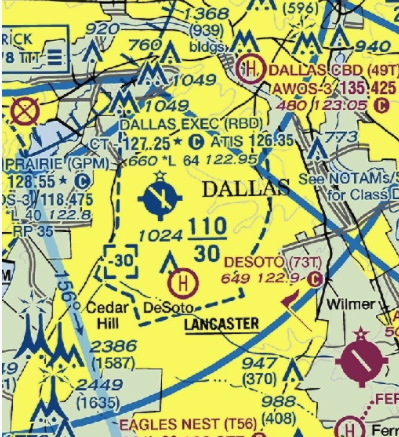
(Refer to FAA-CT-8080-2H, Figure 25, Area 3.) The floor of Class B airspace at Dallas Executive (RBD) is
3,000 feet MSL.
[Class B airports are huge up side down wedding cakes. The B overhangs the Class D airspace. If you see the Class D top says [-30]. The minus means up to but NOT including 3,000. Right near it you see the 110/30 which means Class B is 3,000-11,000 ft.
UA.II.A.K1b General airspace: Class C controlled airspace. (Refer to FAA-CT-8080-2H, Figure 23, area 3.) What is the floor of the Savannah Class C airspace at the shelf area (outer circle)?
1,300 feet MSL.
[Remember the two zeros are chopped off. SFC means surface. Why is this important? Because you might need to do a job under the Class C shelf. If you don’t know this right off the top of your head, you are leaving money on the table. Remember that Class C operations require a waiver (COA). You need to be able to say quickly, “Yes, we can do that job” or “No, we can’t do that job and I’ll have to file a COA to fly in Class C airspace.”
General airspace: Class C controlled airspace. According to 14 CFR part 107 the remote pilot in command (PIC) of a small unmanned aircraft planning to operate within Class C airspace
is required to receive ATC authorization.
[Bingo. Why? Because the FAA ATC wants to make sure you can fly in certain locations. ]

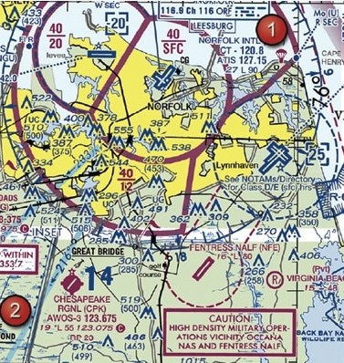
(Refer to FAA-CT-8080-2H, Figure 20, Area 1.) The Fentress NALF Airport (NFE) is in what type of airspace?
Class E [You can tell this based upon the dashed magenta line which indicated E at the surface.]
Special use within airspace. (Prohibited, restricted, warning, military operations, alert, and controlled firing.) (Refer to FAA-CT-8080-2H, Figure 59, area 2.) The chart shows a gray line with "VR1667, VR1617, VR1638, and VR1668." Could this area present a hazard to the operations of a small UA?
Yes, this is a Military Training Route from 1,500 feet AGL.
[It is extremely important to know this so you can expect low-flying military helicopters flying this route. Some of which may be at 400ft or below. Here is what the AIM says: “(a) MTRs with no segment above 1,500 feet AGL must be identified by four number characters; e.g., IR1206, VR1207. (b) MTRs that include one or more segments above 1,500 feet AGL must be identified by three number characters; e.g., IR206, VR207.” What does this mean? They can ALWAYS be flying in your airspace.]
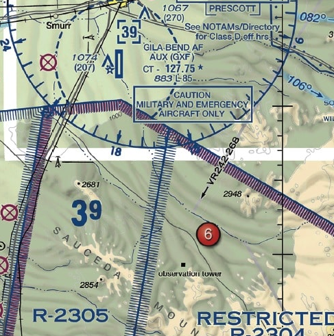
(Refer to FAA-CT-8080-2H, Figure 75, Area 6.) During preflight planning, you plan to operate in R-2305. Where would you find additional information regarding this airspace?
In the Charts Supplements U.S.
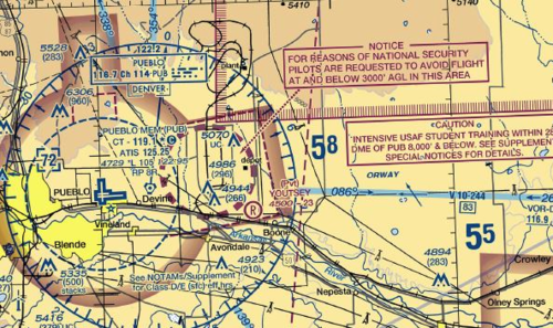
What is the dashed magenta line in a circle east of the Pueblo Airport represent?
This is a national security area.
[This is NOT Class E at the surface. The dashed circle is a national security area. The thinner dashed line in the shape of a box is Class E at the surface extension.]
(Refer to FAA-CT-8080-2H, Figure 23, Area 4.) What is the required flight visibility for a remote pilot operating an unmanned aircraft near the Plantation Airport (JYL)?
C) 3 statute miles.
[I think this is trying to confuse the manned aircraft guys because visibility for Class G operations for manned aircraft is 1 mile of visibility and 3 for E airspace (starts at 700ft AGL around Plantation). Part 107 has visibility at 3 SM of visibility.]
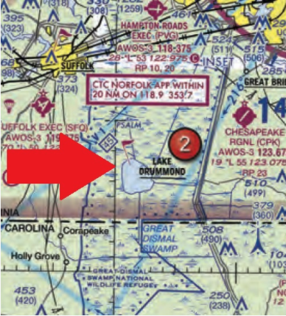
Why would the small flag at Lake Drummond of the sectional chart be important to a remote pilot?
This is a VFR check point for manned aircraft, and a higher volume of air traffic should be expected there.
[Lots of aircraft means greater chance for mid-air collision.]
NOTAM system including how to obtain an established NOTAM through Flight Service. (Refer to FAA-CT-8080-2H, Figure 20, area 5.) How would a remote PIC “CHECK NOTAMS” as noted in the CAUTION box regarding the unmarked balloon?
By obtaining a briefing via an online source such as: 1800WXBrief.com.
[You could do this. I suggest reading my article on 5 Ways to Prove You Did a Pre-Flight Briefing.]
[METAR KLAX 121852Z 25004KT 6SM BR SCT007 SCT250 16/15 A2991
SPECI KMDW 121856Z 32005KT 1 1/2SM RA OVC007 17/16 A2980 RMK RAB35]
Aviation routine weather reports (METAR). (Refer to FAA-CT-8080-2H Figure 12.) What are the current conditions for Chicago Midway Airport (KMDW)?
Sky 700 feet overcast, visibility 1-1/2SM, rain.
[Time, wind direction and speed, visibility in SM, clouds, Temperature/ dew point, altimeter in inches of mercury. It is almost always the same format. Just go through and find the two wrong answers.]
[SPECI KJFK 121853Z 18004KT 1/2SM FG R04/2200 OVC005 20/18 A3006]
Aviation routine weather reports (METAR). (Refer to FAA-CT-8080-2H, Figure 12.) The wind direction and velocity at KJFK is from...
180° true at 4 knots.
[This is how you remember if something is true or magnetic. "If it is in print, it must be true." The only exceptions are for runways, VOR compass rose, and AWOS/ASOS headings when you call from a phone.]
UA.III.B.K1a Weather theory: Density altitude. What effect does high density altitude have on the efficiency of a UA propeller?
Propeller efficiency is decreased.
[A high density altitude decreases the power output of a normal aspirated engine because there are less air molecules in the combustion. Most drones are electric so I'm taking this out of the equation. There are fewer air molecules flying over the wing (the propeller) which results in a decrease in lift.]
Weather theory: Atmospheric stability, pressure, and temperature. What are the characteristics of stable air?
Poor visibility and steady precipitation.
[Yes! stratiform clouds, smooth air, poor visibility in haze and smoke, and continuous precipitation.]
Weather theory: Air masses and fronts. What are characteristics of a moist, unstable air mass?
Turbulence and showery precipitation.
[Cumuliform clouds, turbulent air, good visibility, and showery precipitation are all characteristics of unstable air.]
Weather theory: Fog. You have received an outlook briefing from flight service through 1800wxbrief.com. The briefing indicates you can expect a low-level temperature inversion with high relative humidity. What weather conditions would you expect?
Smooth air, poor visibility, fog, haze, or low clouds.
[A temperature inversion means some warm air on top of some cold air. The cold air underneath on the ground, along with a high relative humidity, means you are expecting fog in the cooler area. The air will be smooth because there is little convection.]
To ensure that the unmanned aircraft center of gravity (CG) limits are not exceeded, follow the aircraft loading instructions specified in the
Pilot’s Operating Handbook or UAS Flight Manual.
A stall occurs when the smooth airflow over the unmanned airplane's wing is disrupted, and the lift degenerates rapidly. This is caused when the wing
exceeds its critical angle of attack.
When operating an unmanned airplane, the remote pilot should consider that the load factor on the wings may be increased anytime
the airplane is subjected to maneuvers other than straight and level flight.
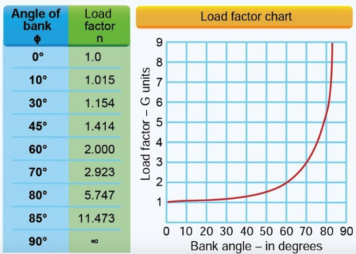
If an unmanned airplane weighs 33 pounds, what approximate weight would the airplane structure be required to support during a 30° banked turn while maintaining altitude?
38 pounds.
[Explanation: In a turn of 30 degrees of bank and while maintaining level flight (no altitude loss because you slightly pitched up), you will have a 1.154 load factor. This means that in this turn you will be feeling like you are pulling 1.154 G's. 33 pounds x 1.154 = 38.082 pounds].

(Refer to FAA-CT-8080-2H, Figure 21, Area 1.) After receiving authorization from ATC to operate a small UA near Minot International airport (MOT) while the control tower is operational, which radio communication frequency could be used to monitor manned aircraft and ATC communications?
CT-118.2.
[This is the control frequency and also is the CTAF frequency.]
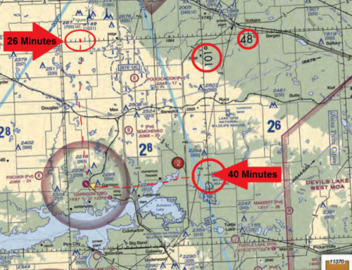
(Refer to FAA-CT-8080-2H, Figure 21.) What airport is located approximately 47 (degrees) 40 (minutes) N latitude and 101 (degrees) 26 (minutes) W longitude?
Garrison Airport.
[Let's make this simple. Ladder sounds kind of like latitude. You climb the ladder going north. (Keep in mind it is north only if you are in the Northern Hemisphere) For minutes, just think of them as tick marks. There is a box with 30 tick marks in it, a line, and then another 30 tick marks. Total you get 60 minutes.]
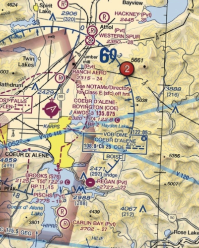
At Coeur D`Alene which frequency should be used as a Common Traffic Advisory Frequency (CTAF) to monitor airport traffic?
122.8 MHz.

A small UA is being launched 2 NM northeast of the town of Hertford. What is the height of the highest obstacle?
500 feet AGL.
[This is a very sneaky question. If you read carefully in the aeronautical chart user's guide on page 12 it says, "Whenever possible, the FAA depicts specific obstacles on charts. However, in high-density areas like city complexes, only the highest obstacle is represented on the chart using the group obstacle symbol to maximize legibility."]
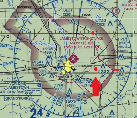
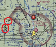
Refer to FAA-CT-8080-2H, Figure 26, area 4.) You have been hired to inspect the tower under construction at 46.9N and 98.6W, near Jamestown Regional (JMS). What must you receive prior to flying your unmanned aircraft in this area?
Authorization from ATC.
[This is Class E airspace going to the surface ASSOCIATED with an airport. The magenta dashes indicate this. According to Part 107, you'll need authorization to operate within Class E at the surface airspace. ]
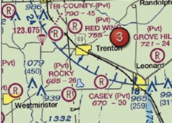
For information about the parachute operations at Tri-County Airport, refer to
Chart Supplements U.S.
[The parachute sign is next to the airport. Legend 1 clues you in to look at the chart supplement even.]
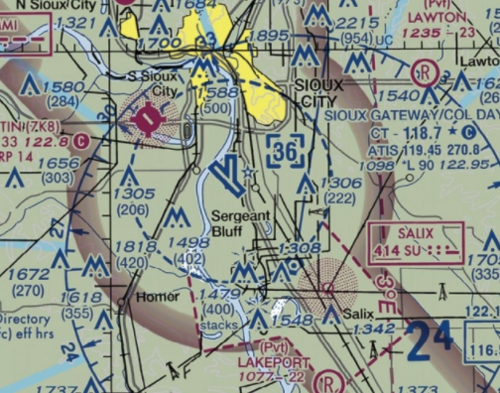
(Refer to FAA-CT-8080-2H, Figure 78. Near the center of the figure.) What class of airspace is associated with SIOUX GATEWAY/COL DAY (SUX) Airport?
Class D airspace.
[This is evidenced by the blue dashes. Technically, it also have some E at the surface airspace extensions which are marked by the dashed magenta lines.]
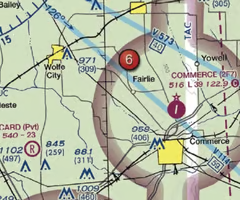
UA.V.B.K6a (Refer to FAA-CT-8080-2H, Figure 24, Area 6.) What type of airport is Card Airport?UA.V.B.K6a (Refer to FAA-CT-8080-2H, Figure 24, Area 6.) What type of airport is Card Airport?
Private non-towered.
[It is private because it has a big R on it. You can tell it is not towered because it is magenta and not blue.]
(Refer to FAA-CT-8080-2H, Figure 26.) What does the line of latitude at area 4 measure?
The degrees of latitude north and south from the equator.
[Like you are climbing a later going up or down. Just remember which hemisphere you are in. 99% of you guys aren’t going below the equator so it will be north most of the time.]
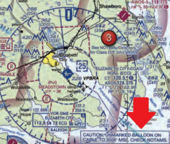
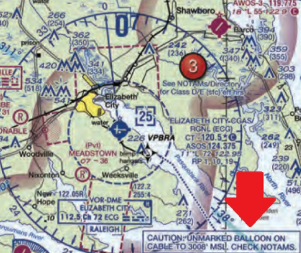
UA.V.B.K6a Sources for airport data: Aeronautical charts. (Refer to FAA-CT-8080-2H, Figure 20, area 3.) With ATC authorization, you are operating your small unmanned aircraft approximately 4 SM southeast of Elizabeth City Regional Airport (ECG). What hazard is indicated to be in that area?
Unmarked balloon on a cable up to 3,008 feet MSL.
[Pilots flying don't have a good way of determining AGL so they use MSL. Keep in mind that if you are flying 4SM from the airport, you are within 4 nautical miles from the airport. Class D airports generally have a radius of 4NM. You would need an airspace waiver to operate in this area.]
The most comprehensive information on a given airport is provided by
the Chart Supplements U.S. (formerly Airport Facility Directory).
[This will tell you all sorts of things. Ever wonder how you get the phone number of the airport manager to make phone calls if you are flying recreationally within 5nm of an airport? This is how!]
When using a small UA in a commercial operation, who is responsible for briefing the participants about emergency procedures?
The remote PIC
To avoid a possible collision with a manned airplane, you estimate that your small UA climbed to an altitude greater than 600 feet AGL. To whom must you report the deviation?
Upon request of the Federal Aviation Administration.
What precautions should a remote PIC do to prevent possible inflight emergencies when using lithium-based batteries?
Follow the manufacturers recommendations for safe battery handling.
Safety is an important element for a remote pilot to consider prior to operating an unmanned aircraft system. To prevent the final "link" in the accident chain, a remote pilot must consider which methodology?
Risk Management.
[This is the part of the decision making process which relies on situational awareness, problem recognition, and good judgment to reduce risks associated with each flight.]
A local TV station has hired a remote pilot to operate their small UA to cover breaking news stories. The remote pilot has had multiple near misses with obstacles on the ground and two small UAS accidents. What would be a solution for the news station to improve their operating safety culture?
The news station should recognize hazardous attitudes and situations and develop standard operating procedures that emphasize safety.
When adapting crew resource management (CRM) concepts to the operation of a small UA, CRM must be integrated into
all phases of the operation.
When a remote pilot-in-command and a visual observer define their roles and responsibilities prior to and during the operation of a small UA is a good use of
A) Crew Resource Management.
[CRM is really the effective use of all available resources: human, hardware, and information. This is highlighting the human portion.]
You have been hired as a remote pilot by a local TV news station to film breaking news with a small UA. You expressed a safety concern and the station manager has instructed you to "fly first, ask questions later." What type of hazardous attitude does this attitude represent?
Impulsivity
Which is true regarding the presence of alcohol within the human body?
Judgment and decision-making abilities can be adversely affected by even small amounts of alcohol.
Identify the hazardous attitude or characteristic a remote pilot displays while taking risks in order to impress others?
Macho
You are a remote pilot for a co-op energy service provider. You are to use your UA to inspect power lines in a remote area 15 hours away from your home office. After the drive, fatigue impacts your abilities to complete your assignment on time. Fatigue can be recognized.
as being in an impaired state.
Which technique should a remote pilot use to scan for traffic? A remote pilot should
systematically focus on different segments of the sky for short intervals.
Under what condition should the operator of a small UA establish scheduled maintenance protocol?
When the manufacturer does not provide a maintenance schedule.
[Yes, because you should know what the mean time between failures is or have an idea on what are the typical problems certain drones encounter so you can PREVENT crashes.]
What actions should the operator of an sUAS do if the manufacturer does not provide information about scheduled maintenance?
The operator should establish a scheduled maintenance protocol.
According to 14 CFR part 107, the responsibility to inspect the small UAS to ensure it is in a safe operating condition rests with the
remote pilot-in-command.
[107.19 says, "(b) The remote pilot in command is directly responsible for and is the final authority as to the operation of the small unmanned aircraft system.]
Under what condition should the operator of a small UA establish scheduled maintenance protocol?
When the manufacturer does not provide a maintenance schedule.
[Yes, because you should know what the mean time between failures is or have an idea on what are the typical problems certain drones encounter so you can PREVENT crashes.]
Class A airspace
18,000ft and above
Class B Airspace
SFC - 10,000 ft MSL
Surrounding nation's busiest airports; upside-down wedding cake; ATC clearance required
Class C Airspace
SFC - 4,000 ft MSL
5 NM radius
A remote pilot must receive authorization
Class D Airspace
SFC-2,500ft MSL
4nm radius
Class E Airspace
Class E airspace is the controlled airspace not classified as Class A, B, C, or D airspace.
In most cases a remote pilot will not need authorization
Class G airspace
Uncontrolled airspace
MTR
Military Training Route
Identified by four number characters (e.g., IR1206, VR1207).
NOTAM
Notice to Airmen
Begins with the phrase "FLIGHT RESTRICTIONS" followed by the location of the temporary restriction, effective time period, area defined in statute miles, and altitudes affected
Explain the METAR report:
(ex. METAR KGGG 161753Z AUTO 14021G26KT 3/4SM +TSRA BR BKN008 OVC012CB 18/17 A2970 RMK PRESFR)
Routine METAR for Gregg County Airport (KGGG) for the 16th day of the month at 1753Z automated source. Winds are 140 at 21 knots gusting to 26. Visibility is 3/4 statute mile. Thunderstorms with heavy rain and mist. Ceiling is broken at 800ft, overcast at 1,200 feet with cumulonimbus clouds. Temperature at 18 C and a dew point 17 C. Barometric pressure is 29.70 "Hg and falling rapidly
TAF
Terminal Aerodrome Forecasts (TAF): is a report established for the five statute miles around the airports. TAF are usually given for larger airports and valid for a 24-30 hour time period with four updates a day (0000Z, 0600Z, 1200Z, and 1800Z) TAF uses the same descriptors and abbreviation as used in METAR
Microburst
the most severe type of low-level wind shear
inversion
As air rises and expands, the temperature decreases
Temperature / Dew Point Relationship
defines the concept of relative humidity. The dew point is the temperature at which the air can hold no more moisture. When temperature reduces to the dew point, the air is completely saturated and moisture begins to condense out of the air in the form of fog, dew, frost, clouds, rain, or snow
Standing Lenticular Altocumulus Clouds
These clouds show little movement, hence the name standing. They are characterized by their smooth, polished edges. Its presence indicates very strong turbulence
What are the characteristics of unstable air?
Cumuliform, showery precipitation, rough air (turbulence), good visibility
usually tends to be hot & humid air
What are the characteristics of stable air?
Stratiform clouds and fog, steady precipitation, smooth air, fair to poor visibility in haze and smoke
cumulonimbus clouds
the most dangerous type of clouds for pilots, usually indicate severe thunderstorms
How many feet below clouds can you legally fly a drone?
must be 500 ft below clouds
How many feet horizontally must you be from clouds?
2,000 ft
Whats the maximum legal speed for a drone?
100 mph
What is the minimum SM visibility permitted to fly a drone?
3 SM
How many hours after drinking alcohol do you have to wait before flying your drone?
8 Hourse
Whats the legal blood alcohol level (BAL) you must have before you can fly?
0.04 BAL
If flying before sunrise or after sunset how many minutes of sunlight must there be?
30 minutes
must have anti collision lights
How many days prior to an accident do you have to file a report with the FAA?
10 days
MSL and AGL
2049 <----MSL
(1149) <--- AGL
What does the red flag represent?
VFR checkpoint (Military)
True vs. Magnetic
on the maps its usually true north
TS life cycle
1. Cumulus
2. Mature (very dangerous)
3. Dissipating
Nimbus clouds
big heavy clouds
stratus clouds
high wispy clouds
CRM
Crew resource management must be integrated into ALL areas
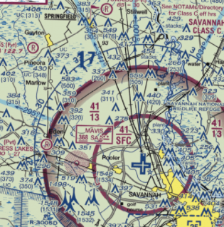
(Refer to FAA-CT-8080-2H, Figure 23, area 3) A client has hired you to inspect a tower on Tuesday. The tower to be inspected is the lighted tower 6 NM SW of Savannah/Hilton Head Intl (SAV). At the highest allowable flight altitude above the tower, what airspace would you be in?
Class C
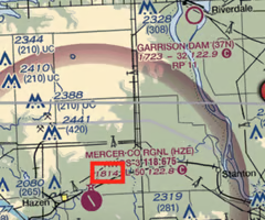
(Refer to FAA-CT-8080-2H, Figure 21, area 3) What is the floor of the Class E airspace surrounding Mercer Co Rgnl (HZE)?
2,514 MSL
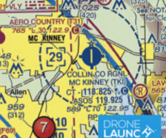
(Refer to FAA-CT-8080-2H, Figure 25, area 7) What is the ceiling of controlled airspace at Collin Co Rgnl McKinney (TKI)?
2,900 MSL
(Refer to FAA-CT-8080-2H, Figure 74, area 3) Where would you go to obtain more information about restricted airspace R-2531?
Notes to Sectional Charts
At what altitude does wind shear occur?
At any altitude
To find out more information about parachute operations in the vicinity of an airport, what would you look at?
Chart Supplements/Airport facilities directory
During a crash, the lithium battery in your UAV is dislodged from its compartment and is found on the ground, 5 feet from the aircraft. You notice a dent in the battery, what should you do?
Assess the condition of the battery and cautiously proceed, following manufacturer's recommendations
It is 7:00 am. Official sunrise is at 7:40 am. Your UAV does not have any anti-collision lighting. How long do you need to wait before you can fly under Part 107?
40 minutes