Earth Science Final
0.0(0)
Studied by 0 peopleCard Sorting
1/310
Earn XP
Last updated 4:23 PM on 4/12/23
Name | Mastery | Learn | Test | Matching | Spaced | Call with Kai |
|---|
No analytics yet
Send a link to your students to track their progress
311 Terms
1
New cards
Earth System Science
everything is connected to everything else on earth - a complex web of energy and matter transfers: connections between the geosphere, hydrosphere, biosphere, and atmosphere.
2
New cards
The influence of human activity on earth systems is significant: how we are impacting systems negatively:
* Deforestation
* Construction of Infrastructure
* Increased gas emission
* Extraction of natural resources
* Overfishing
* Dams
* Changes to natural slopes
* Construction of Infrastructure
* Increased gas emission
* Extraction of natural resources
* Overfishing
* Dams
* Changes to natural slopes
3
New cards
Earth’s interior divided by composition:
* Crust
* Mantle
* Core
* Mantle
* Core
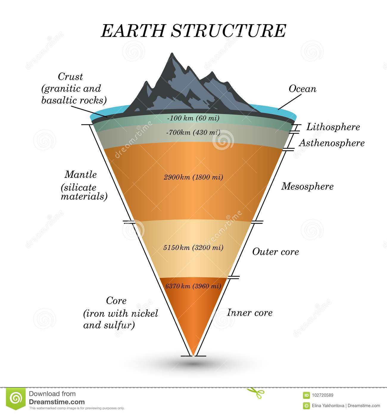
4
New cards
Earth’s interior divided by mechanical properties (rheology):
* Lithosphere
* Asthenosphere
* Mesosphere
* Core
Outer liquid core
Inner solid core
* Asthenosphere
* Mesosphere
* Core
Outer liquid core
Inner solid core

5
New cards
Crust (Oceanic)
* Thin (7km)
* Denser
* Mg-Fe rich
* Denser
* Mg-Fe rich
6
New cards
Crust (Continental)
* Thicker but varies (avg. 30 km, up to 70 km at mountain ranges)
* Lighter
* Si-Al rich
* Lighter
* Si-Al rich
7
New cards
Mantle
* Mg-Fe-Si rich
8
New cards
Core
* metallic
* Ni-Fe rich
* Ni-Fe rich
9
New cards
How do we know the Earth’s compositional structure?
Samples delivered to the surface from the mantle, meteorites, density calculations and composition of the solar nebula
10
New cards
Lithosphere
* Crust & rigid mantle
11
New cards
Asthenosphere
* Plastically flowing, hot, ductile rock
12
New cards
Mesosphere
* Solid but not rigid
* The material becomes less ductile with depth
* The material becomes less ductile with depth
13
New cards
Core
* Outer liquid core
* Inner solid core
High pressure favours solid state
* Inner solid core
High pressure favours solid state
14
New cards
How do we know the Earth’s mechanical structure?
Seismic data provides direct evidence for the earth's internal structure (Velocity, reflection
and refraction of Primary and Secondary seismic waves)
and refraction of Primary and Secondary seismic waves)
15
New cards
Temperature profile (Earths Composition)
Lithosphere
* The temperature rises quite rapidly
* Heat transfer by conduction
• Asthenosphere
* Temperature close to or slightly above melting temperature = some partially molten rock
* Convecting
• Mesosphere
* Convecting slowly
• Core
* Liquid outer core convects
* because the core is metallic, this generates the Earth’s magnetic field
* Solid inner core - heat transfer by conduction
16
New cards
Mantle Plumes
* Column of hot, buoyant mantle rock (not magma) rises from near the core-mantle boundary or from the mid-mantle region and reaches the upper mantle just below the crust.
* Partial melting near the surface = volcanism
* Partial melting near the surface = volcanism
17
New cards
Lithosphere... on the move?
* Broken into large, rigid pieces = plates
* These plates move relative to one another: convection in the mantle is the key driver of plate motions.
* Plates move in different directions and at different rates
* The process associated with plates origin, movement, interactions & destruction known as plate tectonics
* These plates move relative to one another: convection in the mantle is the key driver of plate motions.
* Plates move in different directions and at different rates
* The process associated with plates origin, movement, interactions & destruction known as plate tectonics
18
New cards
Plate Tectonics
7 major plates: North America, Eurasia, Pacific, Africa, Indo-Australian, South American, & Antarctic Plate
* Plate motion ranges from \~ 1-10 cm/yr
* Plate motion ranges from \~ 1-10 cm/yr
19
New cards
Types of plate motion at plate boundaries:
* Convergent
* Divergent
* Transform
Plate boundaries are geologically active!
* Earthquakes
* Volcanic activity
* Divergent
* Transform
Plate boundaries are geologically active!
* Earthquakes
* Volcanic activity
20
New cards
Convergent Plate Motion
where plates collide (subduction zone)
Subtypes:
1. Ocean-continent: ex. Andes or Cascades
2. Ocean-ocean: ex. Japan
3. Continent-Continent: ex. Himalayas'
Implications:
* Friction between plates = periodic earthquakes
* Crustal deformation & thickening
* Sediments accumulated along continent edges pushed up, forming fold-belt mountains: older crustal rocks also get deformed and pushed up.
21
New cards
Divergent Plate Motion
where plates separate (rift)
1. Ocean-ocean: ex. Mid-Atlantic Ridge
2. Continent-continent: ex. East African Rift
Implications:
* Continental break-up
* The new lithosphere is formed at mid-ocean ridges
* Some magma erupts on the seafloor = volcanism
1. Ocean-ocean: ex. Mid-Atlantic Ridge
2. Continent-continent: ex. East African Rift
Implications:
* Continental break-up
* The new lithosphere is formed at mid-ocean ridges
* Some magma erupts on the seafloor = volcanism
22
New cards
Transform Plate Motion
Where plates slide past each other
* San Andreas fault
* Offset segments of mid-ocean ridges
Implications:
* Plates sliding past each other is not smooth ...more like a stick-slip process & when it slips, it generates earthquakes!
* San Andreas fault
* Offset segments of mid-ocean ridges
Implications:
* Plates sliding past each other is not smooth ...more like a stick-slip process & when it slips, it generates earthquakes!
23
New cards
Mineral:
* Made up of atoms
* Specific chemical composition or range of compositions
* **Crystalline solid** - atoms are arranged in a regular, repeating structure
* Naturally occurring
* Specific chemical composition or range of compositions
* **Crystalline solid** - atoms are arranged in a regular, repeating structure
* Naturally occurring
24
New cards
Crystallization:
* a process that forms minerals where atoms bond into an orderly, three-dimensional crystal structure
* Crystal shape is determined by the arrangement of atoms, but... not all crystals show “well-developed” crystal faces which require space to grow.
* Crystal shape is determined by the arrangement of atoms, but... not all crystals show “well-developed” crystal faces which require space to grow.
25
New cards
Silicates
Rock-forming minerals
* Silicon & oxygen are abundant in Earth’s crust and mantle (75% of the crust by weight!)
* Silica tetrahedrons (SiO 4) are the building block of silicate minerals
* Silicates are the most abundant rock-forming minerals
Types:
1. Quartz
2. Feldspars
3. Ferromagnesian minerals
* Silicon & oxygen are abundant in Earth’s crust and mantle (75% of the crust by weight!)
* Silica tetrahedrons (SiO 4) are the building block of silicate minerals
* Silicates are the most abundant rock-forming minerals
Types:
1. Quartz
2. Feldspars
3. Ferromagnesian minerals
26
New cards
Quartz
a form of silicon dioxide (SiO 2)
* Hard
* Glassy
* Fractures conchoidally
* Colourless (impurities make crystals white, purple, grey etc.)
* One of the most abundant minerals on Earth
* Hard
* Glassy
* Fractures conchoidally
* Colourless (impurities make crystals white, purple, grey etc.)
* One of the most abundant minerals on Earth
27
New cards
Feldspars
aluminosilicates
* White, greyish or pinkish
* Blocky
* Will break down to form clays
* White, greyish or pinkish
* Blocky
* Will break down to form clays
28
New cards
Ferromagnesian minerals
* Dark minerals (mostly)
* Not very resistant to weathering
* Different structures
* Examples: olivine, amphibole, pyroxene & mica
* Not very resistant to weathering
* Different structures
* Examples: olivine, amphibole, pyroxene & mica
29
New cards
Other environmentally important rock-forming minerals:
Oxides – bonded with oxygen
* Examples: hematite (iron-oxide – Fe 2 O 3 ) or bauxite (Al 2 O 3 )
* Important metals to industry
Calcite – calcium-carbonate (CaCO3 )
* White or clear
* Softer than quartz
* Reacts with acidic fluids
Gypsum – hydrated sulphate (CaSO 4·H 2O)
* White to clear
* Soft
* Partially soluble in water
Native (pure) elements – only one element
* Examples: gold (Au), silver (Ag), copper (Cu) & diamond (C)
* Generally occur in small accumulations, but occasionally sufficient quantities to produce an economic deposit
\n
30
New cards
What is a rock?
An aggregate of one or more minerals
Rocks are classified into 3 general types based on how they were formed.
Igneous
Sedimentary
Metamorphic
Rocks are classified into 3 general types based on how they were formed.
Igneous
Sedimentary
Metamorphic
31
New cards
Igneous
crystallization of magma
* Slowly at depth (intrusive – up to millions of years)
* Quickly at the surface (extrusive – seconds to minutes)
* Classified based on texture & composition
* Texture: Cooling rate dictates crystal size: Extrusive - small crystals, Intrusive - large crystals
* Composition: Felsic (light minerals) vs Mafic (dark minerals)
* Mafic extrusive rocks – typically form from less explosive volcanism = Lava flows are common (think Hawaii...)
* Felsic extrusive rocks – typically form from explosive volcanism = Ash deposits & ejected volcanic debris
\
Generally hard
Rarely layered
Intrusive igneous rocks, such as granite, are typically coarse-grained and hard; if relatively unfractured, make good construction material
Extrusive igneous rocks, such as basalt, can be highly fractured (fractures upon fast cooling) and/or contain voids created gas bubbles reducing the strength of the rock
32
New cards
Sedimentary
formed from fragmented rocks & minerals or dissolved ions that have been transported, deposited & lithified (cemented or compressed together to form a rock)
1. Clastic sedimentary rocks - Accumulation of rock or mineral fragments (clast or sedimentary grain)
Clast size or grain size can range from:
* Coarse (gravel), ex: conglomerate
* Medium (sand), ex: sandstone
* Fine (silt), ex: siltstone
* Very fine (clay), ex: shale
Layering = sedimentary bedding
\
2. Chemical sedimentary rocks – chemical or biochemical processes cause solid material form from the dissolved material
* Evaporites - when minerals form from the evaporation of water in an inland sea or lake such as **gypsum** or halite (rock salt!)
* Shells & coral (biological - marine organisms extract bicarbonate and calcium ions (HCO 3– and Ca2+) from ocean-water to make calcite shells (CaCO 3)) and/or calcite grains (non-biological) accumulate on the seafloor + buried = Limestone
\
3. Organic sedimentary rocks – accumulation of plant remains
* ex: coal
\
Generally not as hard as igneous & metamorphic rocks
Often layered
Chemical sedimentary rocks contain soluble or partially soluble minerals à water or acidic fluids.
33
New cards
Metamorphic
formed from pre-existing rocks
* Temperature and/or pressure
* Burial
* Crustal deformation & thickening (mountain building)
* Contact with heat source (hot fluids, magma)
* Effects of changing temperature/pressure conditions:
Changes in mineralogy:
* Minerals to become unstable & alter (convert to different mineral)
Changes in texture:
* Larger crystals of the same type
* Foliation: alignment of crystals to due to direction of pressure (metamorphic layering)
\
Foliated metamorphic rocks are layered
* Schist made of soft minerals (micas)
* Gneiss & slate much harder & make good construction materials
Not all metamorphic rocks develop a foliation (massive texture)
* Quartzite (metamorphosed sandstone): crystals grow larger forming a very hard with interlocking crystals
34
New cards
Environmental Considerations: Rocks
1. Mineralogy (mineral composition)
Does it readily break down? (weather to clays?)
Solubility of minerals or metals?
2. Texture (size, shape, arrangement of grains or crystals)
Porosity - the percentage of open space within a rock
Permeability - permeability is related to the sizes of open spaces and how they are shaped and interconnected
How hard a rock is (relative ... sandstone vs granite)
3. Structure
Layers – bedding (sedimentary) & foliation planes (metamorphic)
Folding
Faulting – active or not?
Jointing
35
New cards
Weathering
when a body of rock is exposed to the weather - forces and conditions that exist on earth's surface
But: most rocks form at significant depth and experience relatively constant conditions of high pressure and temperature.
Uplift and erosion of overlaying rocks cause conditions to change drastically:
* Temperature reduces and varies widely
* Pressure is reduced
* Exposed to the atmosphere (oxygen and other gases)
* Water is abundant
\n
36
New cards
Types of weathering:
1. mechanical weathering
* Breakdown of rocks into smaller fragments
* Product: sedimentary clasts, unconsolidated materials
2. Chemical weathering
* Chemical change of minerals within the rock to forms that are stable in the surface environment
* Product: new materials, ions in solution
37
New cards
Mechanical/Chemical weathering interactions:
Mechanical weathering can expose fresh surfaces that can now be chemically weathered
Chemical weathering can weaken the rock, making it more susceptible to mechanical weathering
Important in the production of sediments and necessary ingredients for soil
Chemical weathering can weaken the rock, making it more susceptible to mechanical weathering
Important in the production of sediments and necessary ingredients for soil
38
New cards
Types of mechanical weathering:
1. Exfoliation
* Removal of overlaying rock = decrease in confining pressure
* As a result, the rock expands
* Granitic rock (igneous) = exfoliate parallel to exposed surface
* Why? Tend not to have predetermined planes along which to fracture
* Sedimentary and metamorphic tend to exfoliate along predetermined planes
2. Frost Wedging
* Water seeps into cracks, freezes (expands)
* Result: enlarges the crack and eventually will be wedged away from the outcrop
* Effective where frequent freeze/thaw episodes occur
* Ie: climate where temperatures are close to freezing
* Common feature in areas with effective frost wedging is a talus slope
* Talus slope: fan shaped deposit of fragments removed by mechanical weathering from a steep rocky slope above
3. Salt weathering
* Salt crystal growth pushes rock apart and weakens the rock
* Forms a positive feedback loop - the now larger holes will collect more salt water
* Typically:
* Forms in sandstone or granites
* Costal enviroments
* sunny side of outcrop (south-facing)
* Honeycomb (small) or Tafoni (large)
4. Plants and Animals
* Roots can force their way into cracks = widen cracks and break the rock
* Animals can nindirectly influence weathering
* Burrow in soil and can expose rock to weathering
\n
39
New cards
Weathering vs Erosion
Weathering: breaks down existing rock
Erosion: rocks, rock fragments, or weathered products carried away (removed) from original location
Example: weathering is rock fragments broken off steep face by wedging, erosion is gravity carrying the fragments down the slope
Erosion: rocks, rock fragments, or weathered products carried away (removed) from original location
Example: weathering is rock fragments broken off steep face by wedging, erosion is gravity carrying the fragments down the slope
40
New cards
Agents of erosion:
* Gravity
* Water/waves
* Ice (glaciers)
* Wind
* Water/waves
* Ice (glaciers)
* Wind
41
New cards
Types of Chemical Weathering
Nature of the change highly specific to the material and environmental conditions
* Quartz: unaffected
* Feldspar: readily altered
Important characteristics that lead to chemical weathering:
* Abundance of 02
* Presence of water
* Presence of co2
Water and co2 make carbonic acid
Two main types of chemical weathering:
* Mineral altered to other minerals:
* Ex. feldspar is altered to clay materials by hydrolysis
* Oxidation reactions, such as pyrite, reacting with water and 02 to make sulfuric acid and iron oxide minerals
* Runoff from areas where this is occurring = acid rock drainage (ARD)
* Even rocks with little pyrite (1-2%) can produce significant ARD
* Amplified by mining processes or construction where pyrite-bearing rock is brought to the surface
* Mineral dissolved completely
* Ex. calcite soluble in acidic solutions
\n
42
New cards
Clay:
Clay has two meanings:
* Sediment grain size (,0.004mm) can be a fragment of any material
* Mineral type: clay mineral - sheet silicates with water in the structure, very fine crystals
* Sediment grain size (,0.004mm) can be a fragment of any material
* Mineral type: clay mineral - sheet silicates with water in the structure, very fine crystals
43
New cards
Clay mineral formation:
Clay minerals form through weathering of silicate minerals (ex: feldspar)
* Hydrolysis reaction = water reacts with potassium feldspar to produce clay minerals and ions
* Type of clay mineral that will form depends on what silicate mineral is being altered & temperature, pressure, chemistry of the solutions that are reacting with the mineral
Can also form through other processes:
* Hydrothermal alteration (hot fluids in earth’s crust)
* Burial & lithification of sediments
* Metamorphism
44
New cards
Clay minerals properties:
Soft, weak, erode easily
Implications:
* Slope failure
* Earthquakes: slides smoothly, less likely to cause stick and cause a large earthquake
Small crystals (fine-grained)
Implications:
* Small pores, high surface tension = impermeable
* Prevent dispersal of contaminants
Absorbs water
Implications:
* Swell or expand when wet (weak = slope failure)
* Shrink when dry = cracking pattern
Implications:
* Slope failure
* Earthquakes: slides smoothly, less likely to cause stick and cause a large earthquake
Small crystals (fine-grained)
Implications:
* Small pores, high surface tension = impermeable
* Prevent dispersal of contaminants
Absorbs water
Implications:
* Swell or expand when wet (weak = slope failure)
* Shrink when dry = cracking pattern
45
New cards
Soil formation
Soil is (geologically speaking):
* Loose material that lies in the top few 10’s of cm of the surface
* Includes organic matter
* important in sustaining plant growth
Components:
* 45% mix of minerals (clay minerals, quartz, feldspars, rock fragments)
* 5% organic matter
* 50% empty space (filled with air or water)
We can describe soil texture by the relative proportions of clay, silt and sand
Weathering and accumulation & decay of organic matter are key processes in the formation of soil!
46
New cards
Soil Formation Variables:
Climate:
Average temperature & precipitation amounts play a big factor & affects the rate or presence of:
* Chemical & mechanical weathering
* Plant growth
* Biological activity (decomposition)
* Dissolved materials
* Erosion
Soil forms readily:
* Temperate to tropic conditions
* Moderate amounts of precipitation
\
Parent Material
Different types of bedrock & unconsolidated sediments
* Quartz-rich parent material, (granite, sandstone, or loose sand) = development of sandy soils
* Quartz-poor material (such as shale or basalt) = soils with little sand, and in some cases with elevated clay levels.
Provide important nutrients
* Apatite (calcium phosphate mineral) = source of P to soil
Influences pH of soil
\
Time
Soil needs time to develop (1000’s of years!)
\
Organisms
Animals, microorganisms, fungi, plants
* Increase weathering rates
* Stabilize soil
* Contribute organic matter
\
Topography (relief)
Soil can only develop where surface material can remain in place
Cannot develop in a region where rate of formation is less than rate of erosion (think steepness & slope shape)
\
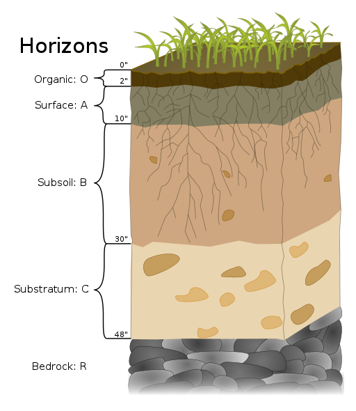
Soil Horizons
O – a layer of organic matter,
A – a layer of partially decayed organic matter mixed with mineral material
E – an eluviated (leached) layer from which some of the clay, dissolved material & other minerals have been removed = a pale layer (may be sandier than the other layers)
B – a layer of accumulation of clay, minerals, and other elements from the overlying soil
C – a layer of incomplete weathering, which grades down into unaltered parent material (R horizon)
R – bedrock
Average temperature & precipitation amounts play a big factor & affects the rate or presence of:
* Chemical & mechanical weathering
* Plant growth
* Biological activity (decomposition)
* Dissolved materials
* Erosion
Soil forms readily:
* Temperate to tropic conditions
* Moderate amounts of precipitation
\
Parent Material
Different types of bedrock & unconsolidated sediments
* Quartz-rich parent material, (granite, sandstone, or loose sand) = development of sandy soils
* Quartz-poor material (such as shale or basalt) = soils with little sand, and in some cases with elevated clay levels.
Provide important nutrients
* Apatite (calcium phosphate mineral) = source of P to soil
Influences pH of soil
\
Time
Soil needs time to develop (1000’s of years!)
\
Organisms
Animals, microorganisms, fungi, plants
* Increase weathering rates
* Stabilize soil
* Contribute organic matter
\
Topography (relief)
Soil can only develop where surface material can remain in place
Cannot develop in a region where rate of formation is less than rate of erosion (think steepness & slope shape)
\
Soil Horizons
O – a layer of organic matter,
A – a layer of partially decayed organic matter mixed with mineral material
E – an eluviated (leached) layer from which some of the clay, dissolved material & other minerals have been removed = a pale layer (may be sandier than the other layers)
B – a layer of accumulation of clay, minerals, and other elements from the overlying soil
C – a layer of incomplete weathering, which grades down into unaltered parent material (R horizon)
R – bedrock
47
New cards
Soil Erosion
Soils held in place by vegetation
Agents of erosion:
1. Water
* Exacerbated on sloped surfaces (fast flowing water greater eroding power)
* Raindrops
* Sheet wash: unchanneled flow across a surface, carrying material away
2. Wind
* Exacerbated by the removal of trees which can act as a windbreak
Agents of erosion:
1. Water
* Exacerbated on sloped surfaces (fast flowing water greater eroding power)
* Raindrops
* Sheet wash: unchanneled flow across a surface, carrying material away
2. Wind
* Exacerbated by the removal of trees which can act as a windbreak
48
New cards
Soils of Canada
1. Podsol
* Well developed A & B horizons
* Forms in cool & humid climates
2. Chernozemic
* Dark-brown, organic-rich, thick A horizon
* Common in grasslands in dry southern prairies
3. Organic
* Areas with poor drainage (swamp)
* Rich supply of organic matter
* Mineral horizon typically absent
4. Cryosols
* In permafrost regions, where glacial retreat recent
* Soil formation short - mostly C horizon
49
New cards
Metals in the Environment
Characteristically hazardous elements :
* As (arsenic), Cd (cadmium), Cr (chromium), Cu (copper), Pb (lead), Zn (zinc), Se (selenium), Hg (mercury), Mn (manganese), U(uranium)
Some elements are essential = it’s the dose that matters
* Nutrient or contaminant?
* Except for ... Pb, As, Hg. No known benefits.
Concentrated elements can lead to...
* Mining & anthropogenic contamination
* Or natural contamination
A concentrated element may pose a risk in one area but not another
Metals don’t get destroyed!
* Released during weathering
* Geologic environment may be the source, pathway or sink for nutrients or contaminants
* As it moves through the environment it interacts with hydrosphere, biosphere, atmosphere
50
New cards
Metal Geoavailability vs Bioavailability
Geo: the amount of a metal that can be liberated during weathering
Bio: the amount of a material that is available for uptake by an organism
Bio: the amount of a material that is available for uptake by an organism
51
New cards
Common elements based on rock type:
* Black shale: As, Zn, Cd, U
* Mafic volcanics: Fe, Mg, Ti, V, Ni, Co
* Felsic intrusives: Si, P, K, Al, Ti, Mn, U, Rn
* Mafic volcanics: Fe, Mg, Ti, V, Ni, Co
* Felsic intrusives: Si, P, K, Al, Ti, Mn, U, Rn
52
New cards
geochemical maps
understand these hazards of metals
* Shows the distribution of elements, in this case for soils
* Often variability in soil chemistry is related to variability in bedrock type
ex: Nova Scotia
* Shows the distribution of elements, in this case for soils
* Often variability in soil chemistry is related to variability in bedrock type
ex: Nova Scotia
53
New cards
What environments are metals more likely to be released?
Mining: brings rocks to surface & processing
Waste disposal: concentrates contaminants
Road construction/building: disruption of surface
Locations of natural weathering
Coastal region: high erosion
Glacial: can transport metals from one area to another & retreat exposes new material to weathering
Waste disposal: concentrates contaminants
Road construction/building: disruption of surface
Locations of natural weathering
Coastal region: high erosion
Glacial: can transport metals from one area to another & retreat exposes new material to weathering
54
New cards
Glacier
long-lasting (decades or more) body of ice on land that is large enough (at least tens of metres thick and at least hundreds of metres in extent) to move under its own weight
* represent largest repository of freshwater on Earth (\~ 69%)
* Glaciation cycles have been approx 100 000 years apart.
* represent largest repository of freshwater on Earth (\~ 69%)
* Glaciation cycles have been approx 100 000 years apart.
55
New cards
Wisconsin Glaciation
* last glaciation
* massive ice sheets covered mostly all of Canada and northern USA
* Laurentide Ice Sheet covered most of eastern Canada as far west as the Rockies
* smaller Cordilleran Ice Sheet covered most of western region
* massive ice sheets covered mostly all of Canada and northern USA
* Laurentide Ice Sheet covered most of eastern Canada as far west as the Rockies
* smaller Cordilleran Ice Sheet covered most of western region
56
New cards
Glacial Ice
• \~ 10% of the Earth’s land surface is currently covered with glacial ice
• most is in Antarctica and Greenland
• many glaciers in other places
• during the past million years, glacial ice was more extensive than it is now covered as much as 30% of the land surface
• most is in Antarctica and Greenland
• many glaciers in other places
• during the past million years, glacial ice was more extensive than it is now covered as much as 30% of the land surface
57
New cards
Glacier Types
Continental glaciers:
* (i.e., ice sheets): cover vast areas of land and only exist in extreme polar regions (Antarctica, Greenland)
Alpine glaciers:
* (i.e., valley glaciers): originate on mountains, mostly in temperate and polar regions, but even in tropical regions if the mountains are high enough typically confined to valleys
58
New cards
Antarctic and Greenland Ice Sheets
• comprise \~ 99% of all of the world’s glacial ice
• comprise \~ 68% of all of the Earth’s fresh water
• comprise \~ 68% of all of the Earth’s fresh water
59
New cards
Glacier Flow Continental Glaciers
• do not flow “downhill” because the large areas they cover are generally flat
• ice flows from the region where it is thickest towards the edges where it is thinner
• thickest parts: areas where rate of snowfall and ice accumulation are highest
• ice flows from the region where it is thickest towards the edges where it is thinner
• thickest parts: areas where rate of snowfall and ice accumulation are highest
60
New cards
Glacier Flow Alpine Glaciers
• controlled by slope of the land beneath
Zone of accumulation: rate of snowfall greater than rate of melting
Zone of ablation: more ice melts than accumulates as snow
Zone of accumulation: rate of snowfall greater than rate of melting
Zone of ablation: more ice melts than accumulates as snow
61
New cards
Equilibrium Line
Feature of Glaciers
Changes each year
Function of the balance between snow accumulation and snow melt
Changes each year
Function of the balance between snow accumulation and snow melt
62
New cards
Glacial Ice Formation
• above equilibrium line, not all of the winter snow melts in the following summer
• therefore snow gradually accumulates
• snow layer from each year is covered and compacted
by subsequent snow
• gradually gets compressed from the weight of overlying snow
• turns into firn within which snowflakes lose delicate shapes and become granules
• granules pushed together and air squeezed out with more compression
• eventually granules are “welded” together to create glacial ice
63
New cards
Glacier Movement
• gravity causes glacial ice to move downhill (or down from an area of thicker ice in the case of continental glaciers)
• front edge is usually melting or calving into water (shedding icebergs)
• front edge is usually melting or calving into water (shedding icebergs)
64
New cards
Glacial Erosion
• glaciers are effective agents of erosion, especially where ice is not frozen to its base and can slide over the bedrock or other sediment
• ice itself it not particularly effective at erosion because it is soft
• erosion caused by the rock fragments embedded in the ice that are pushed down onto
underlying surfaces
• differences between continental and alpine glaciation
• ice itself it not particularly effective at erosion because it is soft
• erosion caused by the rock fragments embedded in the ice that are pushed down onto
underlying surfaces
• differences between continental and alpine glaciation
65
New cards
Glacial Erosion: Continental
• produces relatively flat bedrock surfaces
• in areas with different rock strengths, glacier will erode softer and weaker rock more effectively than harder and stronger rock
• much of central and eastern Canada, which was completely covered by the huge Laurentide Ice Sheet, has been eroded to a relatively flat surface
• in the mountainous regions of western Canada, the Cordilleran Ice Sheet eroded and accentuated deep valleys and plateaus
66
New cards
Glacial Erosion: Alpine
• causes topographic variability of mountains in temperate regions
• glaciers erode more at bases than their sides, so they form wide valleys with relatively flat bottoms and steep sides, known as U-shaped valleys
• Howe Sound, north of Vancouver was occupied by a large glacier that originated in the Squamish, Whistler, and Pemberton areas (then joined much larger glacier in the Strait of Georgia)
67
New cards
Glaciation Key Terms
**arêtes:** sharp ridges between U- shaped glacial valleys
**cols:** low points along arêtes that constitute passes between glacial valleys
**horns**: steep peaks that have been glacially and freeze-thaw eroded on three or more sides
**cirques**: bowl-shaped basins that form at the head of a glacial valley
**hanging valleys**: U-shaped valleys of tributary glaciers that hang above the main valley because the larger main-valley glacier eroded more deeply into the terrain
**truncated spurs:** the ends of arêtes (a.k.a. “spurs”) that have been eroded into steep triangle-shaped cliffs by the glacier in the corresponding main valley
**Drumlin:** elongated feature that is streamlined at the down-ice end. Drumlins made of glacial sediments common in some areas of continental glaciation
**Roche moutonée:** elongated erosional feature that has a steep and sometimes jagged down-ice end
**Glacial grooves** (10s of cm to m wide) and glacial striae (mm to cm wide) are created by fragments of rock embedded in the ice at the base of a glacier
**Glacial striae** are very common on rock surfaces eroded by both alpine and continental glaciers
\n
Lakes: typical glacial environment features
**tarn** = lake confined to a glacial cirque, common in areas of alpine glaciation because ice that forms cirque carves out a depression that fills with water
**finger lake** = lake not confined to a glacial cirque, can be confined by a dam formed by an end moraine (moraine lake)
68
New cards
Glacial Flooding
• crust depressed by weight of glacial ice
• basins form along edges of continental glaciers that fill with glacial melt water
Example: Glacial Lake Missoula
• ice retreated enough to allow some of the lake water to start flowing out
• this escalated into a massive and rapid outflow (over days to weeks)
• much of the lake volume drained into the Columbia River and Pacific Ocean
• rate of outflow was equivalent to the discharge of all of the Earth’s current rivers combined
69
New cards
Glacial Deposits
Ice surface is partially or completely covered with rocky debris that fell from surrounding steep rock faces = Muddy rivers coming from the glacier in several locations that deposit sediment
• on land
• into Vitus Lake
• directly into ocean
Dirty icebergs shed sediment into the lake
Sediments are moved beneath the ice
Massive amounts of water flow on the surface, within the glacier, at the base of the glacier
• water moves sediments
• most material is washed out of the lower end of the glacier and deposited as outwash sediments
• sediments accumulate in proglacial region (area in front of glacier) most in fluvial (river environments) also in lakes and oceans
70
New cards
Sediments in Glacial Environments
supraglacial = on top of ice
englacial = within the ice
These sediments slide off the melting front of a stationary glacier and can form a ridge of unsorted sediments called an end moraine.
terminal moraine = the end moraine that represents the furthest advance of glacier
englacial = within the ice
These sediments slide off the melting front of a stationary glacier and can form a ridge of unsorted sediments called an end moraine.
terminal moraine = the end moraine that represents the furthest advance of glacier
71
New cards
Sub-glacial Till
• material eroded from underlying rock by ice
• moved by ice
• emplaced on the bed by friction generated by weight of overlying ice
• wide range of grain sizes
• high proportion of silt and clay
• larger clasts (pebbles to boulders in size) tend to get partly rounded by abrasion
• moved by ice
• emplaced on the bed by friction generated by weight of overlying ice
• wide range of grain sizes
• high proportion of silt and clay
• larger clasts (pebbles to boulders in size) tend to get partly rounded by abrasion
72
New cards
Lodgement Till
Deposits beneath the glacier that are forced into the bed below
• exposed as sheet of well-compacted sediment when glacier melts
• several cm to many metres in thickness
• exposed as sheet of well-compacted sediment when glacier melts
• several cm to many metres in thickness
73
New cards
Ablation Till
• most of the material is deposited on the ground when the ice melts (ablation till)
ablation till:
• mixture of fine and coarse angular rock fragments
• typically has less sand, silt, and clay than lodgement till
• less well compacted than lodgement till
ablation till:
• mixture of fine and coarse angular rock fragments
• typically has less sand, silt, and clay than lodgement till
• less well compacted than lodgement till
74
New cards
Supra-glacial Sediments
• primarily derived from freeze- thaw eroded material that fell onto ice from rocky slopes above
• form lateral moraines
• form medial moraines where two glaciers meet
When supraglacial sediments get incorporated into the body of the glacier they are known as englacial sediments
• form lateral moraines
• form medial moraines where two glaciers meet
When supraglacial sediments get incorporated into the body of the glacier they are known as englacial sediments
75
New cards
A Sandur
• large proglacial plain of sediment deposition
• glacio-fluvial deposits can be tens of metres thick
• glacio-fluvial deposits can be tens of metres thick
76
New cards
Glacio-fluvial Sediments
• generally similar to sediments deposited in normal fluvial environments
• dominated by silt, sand and gravel
• grains tend to be moderately well rounded
• sediments have sedimentary structures that are similar to those formed by non-glacial streams
• dominated by silt, sand and gravel
• grains tend to be moderately well rounded
• sediments have sedimentary structures that are similar to those formed by non-glacial streams
77
New cards
Kettle Lakes
When a glacier is receding, a block of ice might become separated from the main ice sheet and then could get buried in glacio-fluvial sediments.
• when the ice block eventually melts, a depression will form
• if this fills with water it is a kettle lake.
• when the ice block eventually melts, a depression will form
• if this fills with water it is a kettle lake.
78
New cards
Eskers
• subglacial stream will create its own channel within the ice
• sediments transported and deposited by the stream will build up within that channel
• when ice recedes, that sediment will remain to form a long sinuous ridge (esker)
• most common in areas of continental glaciation
• can be several metres high, tens of metres wide, tens of kilometres long
• sediments transported and deposited by the stream will build up within that channel
• when ice recedes, that sediment will remain to form a long sinuous ridge (esker)
• most common in areas of continental glaciation
• can be several metres high, tens of metres wide, tens of kilometres long
79
New cards
Proglacial Lake Processes
• outwash streams flow into proglacial lakes where glacio-lacustrine sediments deposit
• dominated by silt- and clay-sized particles (mm scale)
• varves can develop (series of beds that each has distinctive summer and winter layers)
summer: high melt discharge -> coarse sediments deposit winter: low discharge -> finer sediments deposit
• icebergs common on proglacial lakes
• most contain englacial sediments
• as icebergs melt, the released clasts sink to the bottom and get incorporated into the glacio-lacustrine layers as drop stones
The processes that occur in proglacial lakes can also take place where a glacier terminates in the ocean; these are called glacio-marine sediments.
80
New cards
Glaciers and Climate Change
• glaciers are highly sensitive to changes in climate
• in the current warming climate, glaciers everywhere are melting rapidly
• some of the larger glacial masses will still last for centuries
• many smaller glaciers will be gone within decades, in some cases within years
• in the current warming climate, glaciers everywhere are melting rapidly
• some of the larger glacial masses will still last for centuries
• many smaller glaciers will be gone within decades, in some cases within years
81
New cards
Receding Glaciers
• globally, most glaciers are receding
• total glacial ice loss has been several hundred Gt/y for most of the past three decades
• as climate has continued to warm, rate has increased
• total glacial ice loss has been several hundred Gt/y for most of the past three decades
• as climate has continued to warm, rate has increased
82
New cards
Glacier Loss in Glacier National Park
• four of the largest park’s glaciers lost 20 – 50% of their area over the past 50 years
• smaller parks lost 45 – 85%
• smaller parks lost 45 – 85%
83
New cards
Alpine and Ice-Sheet Outflow Glaciers
• loss of mass increasing by about 20% per year
• thinning rates have doubled over the past two decades
• some of the greatest losses are in the area of Alaska, Yukon and British Columbia
• Asian glacier loss rates are amongst the lowest
• thinning rates have doubled over the past two decades
• some of the greatest losses are in the area of Alaska, Yukon and British Columbia
• Asian glacier loss rates are amongst the lowest
84
New cards
Consequences of Ice Loss
• when glaciers shrink, bare rock is exposed (albedo changes)
• sea level rise
• contribution of high fresh water levels to oceans (changes to ocean salinity affect surface and deep ocean currents)
• melting permafrost -> CO2 and methane release -> more warming
• enlarged lakes -> increased risk of glacial outburst floods
• increased risk of slope failure (lack of ice on slopes)
• less reliable sources of drinking and irrigation water
• effects on fish and other aquatic life
• threatened economic opportunities from tourists and recreation
• less reliable sources of drinking and irrigation water
• billions of people depend on glacial meltwater for drinking and for agriculture (especially in dry summers)
• example: Berg Glacier contributes to flow of the Fraser River (water source for many communities in BC)
as glaciers lose volume, summertime flow of rivers decreases and less water is available
\n
85
New cards
Glaciers and Water Storage
• glaciers store water that would otherwise flow quickly through the hydrological system
• significant implications for flow rates at different times of year
• significant implications for flow rates at different times of year
86
New cards
Glaciers and Sea Levels
• glaciers (esp. large continental ice sheets) contain a lot of frozen water
• strong control on sea level
• periods of extensive glaciation: avg sea level can be > 100 m lower than it is now
• when there is little or no glacial ice, sea level would be \~ 70 m higher than it is now • variations lead to changes in coastal processes
• albedo changes (reflective ice and non-reflective sea water)
87
New cards
Other Contributions of Glaciers to Earth System Processes
• glaciers play an important role in shaping mountainous areas into steep slopes
• leads to slope failures and enhanced erosion
• produce a tremendous amount of sediment which has implications for biological processes on land and in the ocean
• leads to slope failures and enhanced erosion
• produce a tremendous amount of sediment which has implications for biological processes on land and in the ocean
88
New cards
Karst
landscape or terrain that results from the weathering of bedrock types that are soluble in water
Bedrock types are primarily limestone and marble dolostone (or dolomite), gypsum, halite sandstone and quartzite (rarer cases)
Bedrock types are primarily limestone and marble dolostone (or dolomite), gypsum, halite sandstone and quartzite (rarer cases)
89
New cards
Karst Landscapes:
Characterized by surface features such as:
* sinkholes
* lack of surface streams
* subsurface network of openings or cavities
Characteristics depend on:
* soluble bedrock type
* climatic environment (precipitation, temperature)
* geographic position (global and local)
* overlying soil materials
* vegetation cover
* sinkholes
* lack of surface streams
* subsurface network of openings or cavities
Characteristics depend on:
* soluble bedrock type
* climatic environment (precipitation, temperature)
* geographic position (global and local)
* overlying soil materials
* vegetation cover
90
New cards
Karstification:
Process dominated by chemical dissolution of soluble bedrock
1. Co2 from atmosphere dissolves in rainwater falling to the surface
2. Water becomes further enriched in co2 as it infiltrates soil
3. Results in slightly acidic water
* Contracts soluble bedrock (limestone)
* Promotes a chemical reaction that slowly dissolves bedrock
Existing rock fractures/crevices preferentially widen and form larger cracks, allowing more water flow and dissolution
* Cracks widen, and mechanical erosion occurs as loose rock fragments transported by water rub against the sides of the openings, some of which form caves
Other factors: bedrock attributes, thickness and type of soil cover, elevation
91
New cards
Bedrock attributes:
1. Chemical purity
* example: more calcite in a limestone -> greater dissolution potential
2. Fracturing
* enhances water flow
* provides preferential sites for conduit development
3. Thickness
4. Geometrical shape
* tilted, folded, interbedded
92
New cards
Soils
1. Soils rich in organic matter (e.g., forest floor or swamp) have higher levels of CO2
* Acidic rainfall or surface waters more acidic = enhances dissolution proccess
2. thick, relatively impermeable soils (e.g., compacted glacial till drift cover) can protect soluble bedrock types from dissolution
93
New cards
Elevation (Karst development)
1. Hydraulic head: elevation change in the topography
* Drives water flow
2. A soluble bedrock unit that extends from a high elevation to a low elevation (great topographic relief ) is likely to have a greater potential for karst development than one at a uniform lower elevation
94
New cards
Karst Importance
* 15-20% of earth's surface is underlain by soluble bedrock types (limestone) that can form karst
* Human interaction: karst aquifers provide main water source in many areas (25% of US groundwater comes from Karst)
* Caves are depositories for critical information on past life forms, (fossils) ancient cultures, and paleoclimates
* Human interaction: karst aquifers provide main water source in many areas (25% of US groundwater comes from Karst)
* Caves are depositories for critical information on past life forms, (fossils) ancient cultures, and paleoclimates
95
New cards
Karst System:
3D landscape composed of
* Interlinked sub-components of the karst geosphere (bedrock and soil)
* Karst hydrosphere
* Karst atmosphere
* Karst biosphere
* Continuous interchange of materials and energy between the components
* Interlinked sub-components of the karst geosphere (bedrock and soil)
* Karst hydrosphere
* Karst atmosphere
* Karst biosphere
* Continuous interchange of materials and energy between the components
96
New cards
Karst ecosystem:
* all plants and animals living in or using karst
* some species are highly specialized
* other species opportunistically colonize karst environments or use karst features
Examples:
* bats use caves for roosts or sites of hibernation
* deer and bears use sinkholes and cave entrance zones for thermoregulation sites = cooler in heat of summer and warmer in winter
* aquatic systems can be highly productive
* fishes use cave and karst conduit systems for spawning, shade, as protection from predators
97
New cards
Karst around the world:
\~20% of land area underlain by carbonate bedrock has potential to form karst
BUT \~1/3 of that is unsuitable for present day karst development because of unfavourable climate burial with overlying materials low relief
BUT \~1/3 of that is unsuitable for present day karst development because of unfavourable climate burial with overlying materials low relief
98
New cards
Karst in North America
* karst of some form or another can be found in almost all the provinces, territories, and states
* Canada has one of the widest ranges of karst types in the world
* \~ 10-15% of Canada is underlain by limestone, dolomite and evaporate rocks (halite and gypsum)
* examples of karst types include gypsum karst in Nova Scotia, halite (or rock salt) karst in Saskatchewan, forested karst in coastal British Columbia, alpine karst in the Canadian Rockies, and arctic karst in the far north
99
New cards
Karst Surface Features (small-scale)
Most small-scale karst features (mm to cm in size) are associated with linear channels, furrows, or grooves forming on soluble rock outcrops or rock faces (especially limestone)
Karren: complex array of solutional forms and patterns generally found on limestone surfaces
ex.
rillen karren (shallow channels with sharp ridges 2 - 3 cm apart)
rund karren (rounded channels separated by rounded ridges)
rinnen karren (flat bottom grooves a few cm deep)
spitz karren (large groves extending down steep spires)
* Based on morphological characteristics and sizes
100
New cards
Karst Surface Features (large-scale)
Karst feature classification usually based on morphological characteristics (shape, dimensions) rather than their genetic origin
In some cases, the function (e.g., input /output of water and air) of karst features is also used as part of the classification
In some cases, the function (e.g., input /output of water and air) of karst features is also used as part of the classification