Sed Strat Week 8
1/37
Earn XP
Description and Tags
fluvial (river) and alluvial environments
Name | Mastery | Learn | Test | Matching | Spaced | Call with Kai |
|---|
No analytics yet
Send a link to your students to track their progress
38 Terms

Erosion zone
streams are actively downcutting, removing bedrock from the valley floor and from the valley sides

Transfer zone
gradient is lower and streams and rivers are not actively eroding, but this is not a site of deposition
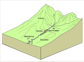
Depositional zone
sediment is deposited in the river channels and on the floodplains of a fluvial system or on the surface of an alluvial fan
Drainage basin (catchment)
area of ground that supplies water to a river system
Perennial fluvial systems (high water table)
Large river systems with catchment areas that experience year-round rainfall, with discharge showing only moderate fluctuations through the year
Ephemeral rivers (low water table)
Rivers that have smaller drainage basins and/or seasonal rainfall with variable discharge
Low flow stage
water level is well below the level of the channel banks
High flow stage
River with water flowing close to or at the level of the bank
As water flows in a channel, it is slowed down by…
Friction with the channel floor, banks, and air above. These effects decrease moving away from the sides, where velocity is fastest in the middle of the river
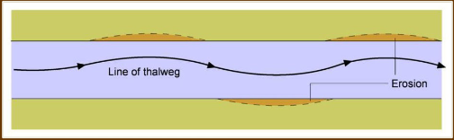
Thalweg
line of the deepest part of the channel
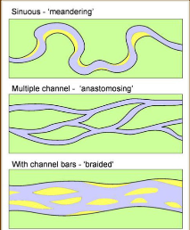
Braided river
Excessive sediment input exceeds river capacity, causing channels to split. Contains mid-channel, migratory bars that are covered at high flow stage; shallow channels interconnect. Weak upward fining
Characterized by highly variable discharge; may be temporary

Anastomosing river
Contains mid-channel bars with sinuous channels that flow around them, but the bars do not migrate like those of a braided river, often due to vegetation. Occur on low-gradient slopes w/ fine grained sediment
Characterized by stable discharge

Meandering river
Sinuous river with depositional bars only on the insides of the bends.
Characterized by stable discharge
Competence
grain size of sediment that can be transported, and relates to the strength of flow (velocity, shear stress
Capacity
total volume of sediment that can be moved, and is a reflection of the magnitude of the discharge
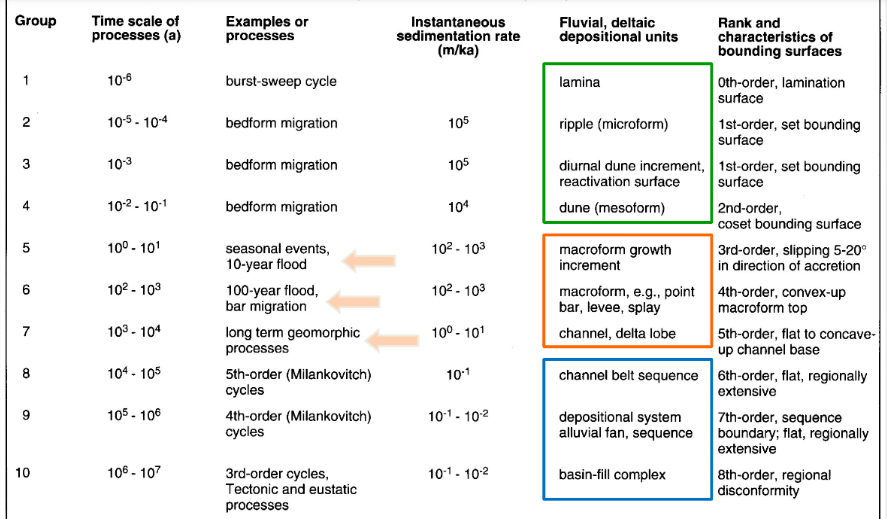
Bounding discontinuities
Erosional surfaces (discontinuities) representing a period of non-deposition that separate and define one sedimentary unit from another. Mark contacts of units
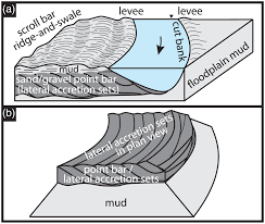
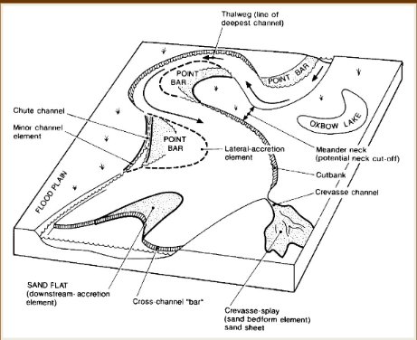
Lateral accretion deposits
River flow piles up on the cutbank, eroding it and causing sediment to deposit on the point bar further downstream. As a result, the bar migrates laterally (horizontally). Upward fining due to decreasing velocity up the point bar
develop on inside of meander bends
Burst-sweep event
low speed fluid ejections (bursts) lifting away from the wall followed by high velocity flow that sweeps grains along on the bottom of the channel
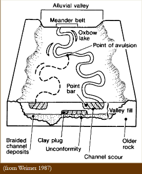
Avulsion
Sudden, high velocity flow causes the river to jump its channels and spill into the steeper floodplain, creating a crevasse splay or diverging channel.
Happens when river channel aggrades above the floodplain
Lag deposit
accumulation of coarse-grained material (gravel, pebbles, boulders) left behind after finer particles are removed by water erosion
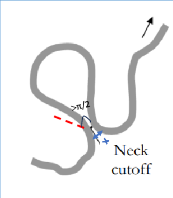
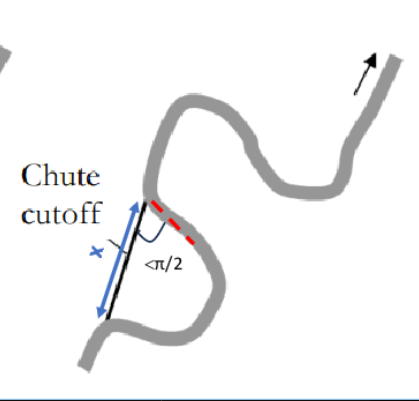
Neck cutoff
fast-flowing meander bend erodes through the narrow strip of land (the neck) separating two adjacent bends, usually during floods. Creates oxbow lakes
Chute cutoff
High-energy floodwaters carve a new, straight channel across the floodplain inside a meander bend. Also creates oxbows
Braided river bars
Lateral bar, longitudinal bar, transverse bar
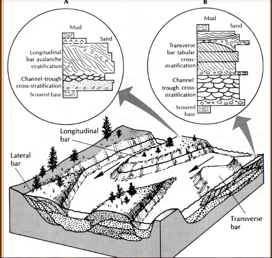
Bar accretion types
Upstream, downstream, or lateral to current
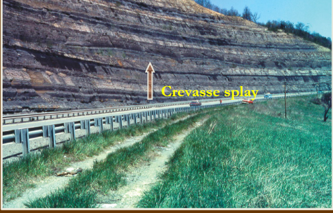
Crevasse splay deposits
Initial upward coarsening. Often sandy, fan-shaped bedforms which accrete into the floodplain due to breaks in the channel/levee
Laminated sand sheets
Tabular units characterized by primary current lineation. Thickest near channel bank because coarse suspended load is dumped quickly by floodwaters. Result of upper regime flow, may form in swash zones
Overbank fines (floodplain deposits)
Highly variable; in tropical climates, coal may develop in a raised mire, while in arid climates, nodular calcretes and silcretes may develop due to alternating periods of rain and evaporation
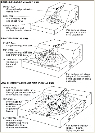
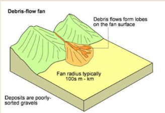
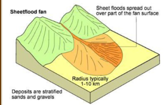
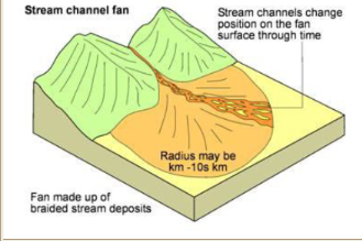
Alluvial fan
Fan-shaped splay formed when rivers spill out from a confined mountain valley onto the basin floor. Avulsion happens as floods occur, and splitting streams divert to the steepest slope. Characterized by upward thickening/coarsening
formed through braided streams, debris flows, and meandering
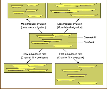
Architecture of fluvial deposits
determined by subsidence rate and avulsion frequency. High subsidence w/ high avulsion means deposits are smaller and more isolated. Low subsidence w/ low avulsion means more lateral accretion and wider, interconnected deposits
Debris flow
Poorly sorted, mud-dominated matrix with possible inverted grading. Larger angular clasts are often carried on top of the flow; travels due to strength of matrix
Sheetflood
Surges of sediment-laden water. Well-sorted sheetlike deposits of gravel, sand, or silt. May be cross-bedded, laminated, or structureless
Stream channel
Long, narrow bodies consisting of the coarsest, most poorly sorted sediments. Common in braided river flow
Fan delta
Alluvial fan that grades directly into a standing water body
Oligotrophic
Lakes that have a narrow band of shore vegetation and low concentration of nutrients/plankton. Sparse fish population, steep shoreline
Eutrophic
Dense, wide band of vegetation on shoreline with high concentration of nutrients/plankton. Dense fish population with gentle slope, decomposition causes fish to stay closer to the surface
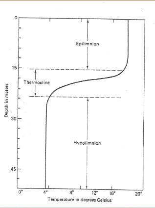
Thermocline
Distinct, thin layer in oceans/deep lakes separating warm, mixed surface water from cold, dense water, where temperature drops rapidly with depth
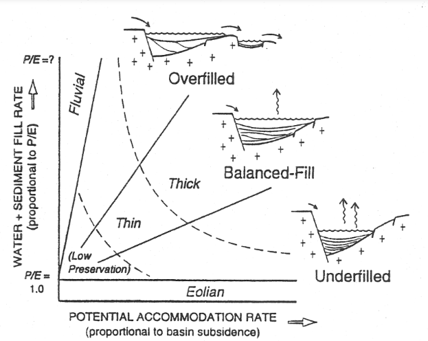
Lake model (based on subsidence and fill rate)
Accommodation space increases with more arid conditions while fill rate increases with more fluvial environments
Ridge and swale topography
alternating parallel ridges and low-lying, marshy depressions (swales) formed by receding water levels, such as shifting rivers (scroll bars) or retreating lake/ocean shorelines