6) Fire Hazards
1/35
There's no tags or description
Looks like no tags are added yet.
Name | Mastery | Learn | Test | Matching | Spaced |
|---|
No study sessions yet.
36 Terms
wildfires
SPECIFICATION
Nature of wildfires. Conditions favouring intense wild fires: vegetation type, fuel characteristics, climate and recent weather and fire behaviour. Causes of fires: natural and human agency. Impacts: primary/secondary, environmental, social, economic, political. Short and long-term responses; risk management designed to reduce the impacts of the hazard through preparedness, mitigation, prevention and adaptation.
Impact and human responses as evidenced by a recent wild fire event.
- brush fires (low-lying desert vegetation)
- bush fires (australia)
- forest fire
- desert fire
- grass fire
- hill fire
- peat fire
- vegetation fire
- veld fire (South Africa)
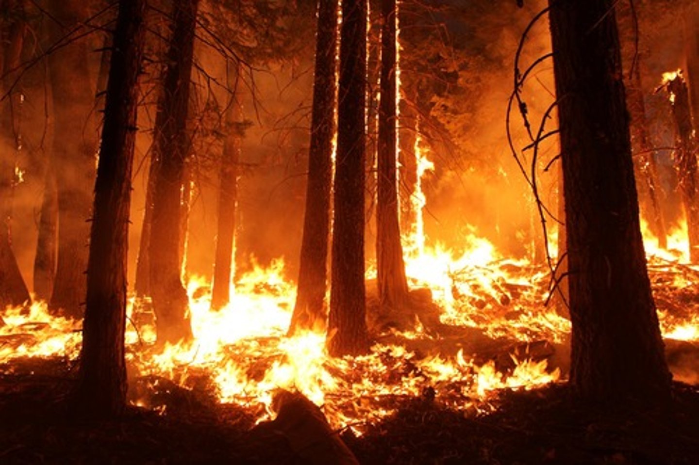
USA wildfires
more than 100,000 wildfires clear 2 million hectares of land every year
... a wildfire moves at speeds of up to 20km/h, consuming everything it its path
(trees, brush, homes, human life all lost)
fires in LA have bee burning for at least 2 months
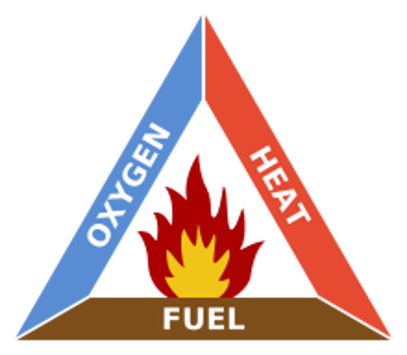
the fire triangle
... 3 conditions that need to be present in order for a wildfire to burn
fuel = any flammable material surrounding a fire (trees, grasses, brush, homes)
... the greater an area's fuel load, the more intense the fire
air = supplies the oxygen a fire needs to burn (16% oxygen is required)
heat = sources that help spark the wildfire and bring fuel to temperatures hot enough to ignite
Australia's wildfires: September 2019 - March 2020
- 24.3 million hectares burned
- over 3,000 homes destroyed
- at least 34 people killed
conditions favouring intense wildfires
Fire behaviour
source of ignition
malicious ignition = arson
accidental human activity = barbeque's, campfires
natural = lightning, volcanic activity
fuel characteristics and vegetation types
... leaf litter, has to be dry to be able to ignite
... the more leaf litter/vegetation, the more fuel available to catch fire
...type and amount influence the intensity and rate of spread
climate and recent weather conditions
... warm and wet enough for vegetation to grow, then a long period of warm dry weather is needed to dry out the fuel
... moisture content is also a significant factor in wildfire formation as reflect the seasonal variation in rainfall and the dry and wet seasons
...Strong winds are also needed to fan the fire
e.g.,
Black Saturday fires in Australia (2009) were driven by winds of up to 125km/h
why does Australia frequently suffer from wildfires
Australia suffers from so many wildfires because they have a lot of fuel:
...common trees like eucalyptus are fire promoting
... during intense fires, highly volatile oils within the leaves can explode and add to the combustion
Causes of wildfires
only 10% are naturally caused (lightning, volcanic activity)
90% are directly caused by people
4/5 wildfires started by humans
o Nature helps to fan the flames with dry weather and drought covert green vegetation into bone-dry flammable fuel
- Strong winds spread fire quickly over land
- Warm temperatures encourage combustion
victoria bushfires causes
(20 year average)
- 25% were deliberately started by arson
- 69% were started by human activity (known)
impact of human activity in causing wildfires
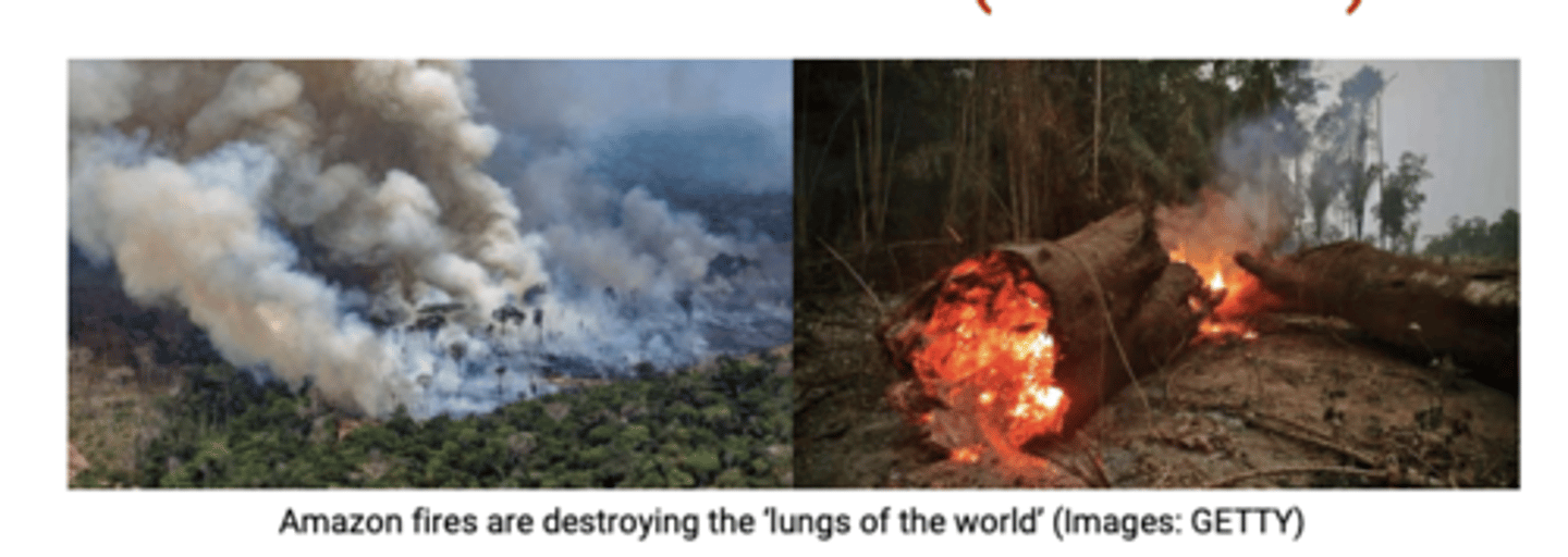
Many naturally fire-resistant ecosystems are being disturbed by human activities, reducing their natural fire resistant's by changing their climates and making them more flammable
e.g., Amazon Rainforest, Malaysian Peat Swamps
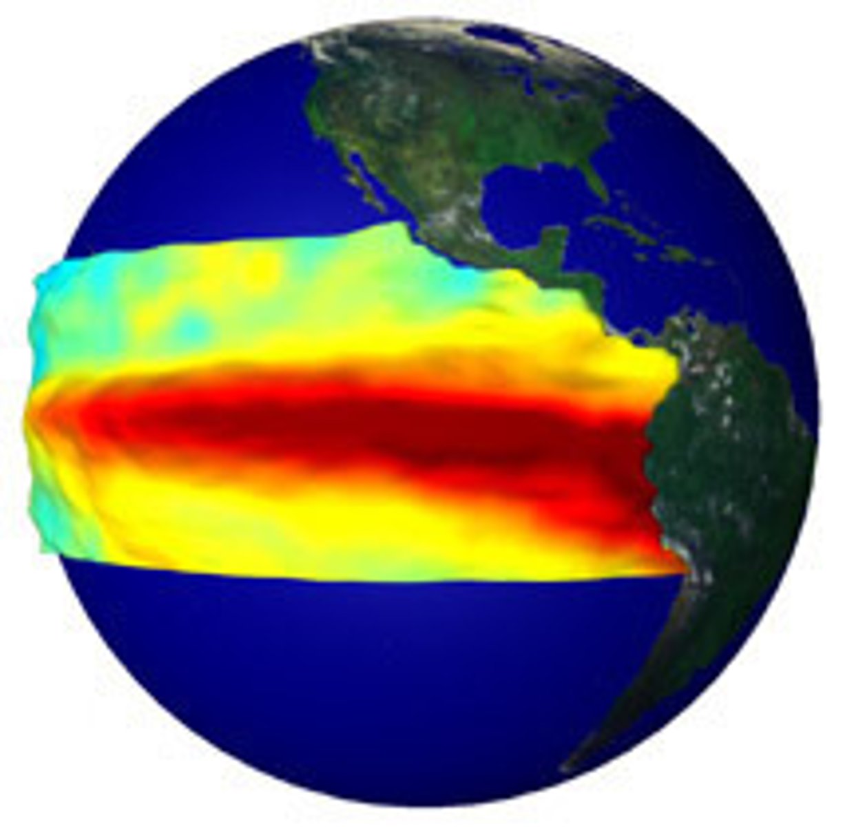
El Nino
= a cyclical climatic condition that occurs on average every 7 years
... Extreme weather conditions caused by the reversal of the "normal" ocean currents
=> Atmospheric and oceanic circulation in the Pacific
- Affects global patterns of temperature and rainfall
- west of current suffer from devastating floods (Peru, LA)
- east of current are affected by prolonged periods of drought (Australia, Indonesia)
2016 Alberta Wildfire, Canada, and Australia's Ash Wednesday fire 1983 were partly attributed to strong El Nino events
- NASA research on Indonesian Forest Fires in 1990's suggested there were clear links between El Nino warming events and Carbon Monoxide pollution plumes associated with forest fires
... also a reduction in rainfall in Indonesia which coincided with an increase in forest fires
Stages of weather conditions leading to Southern California wildfires
1. Santa Ana desert winds originate from a clockwise flow of air around a high-pressure system east of the Sierra Nevada Mountains
2. Air from the mountains was compressed and warmed, becoming less humid
3. Lower humidity dried out vegetation and fanned existing fires
4. Winds squeezed through canyons with gusts between 65-95km/h
5. Strong winds create turbulence and can make interstate travel difficult
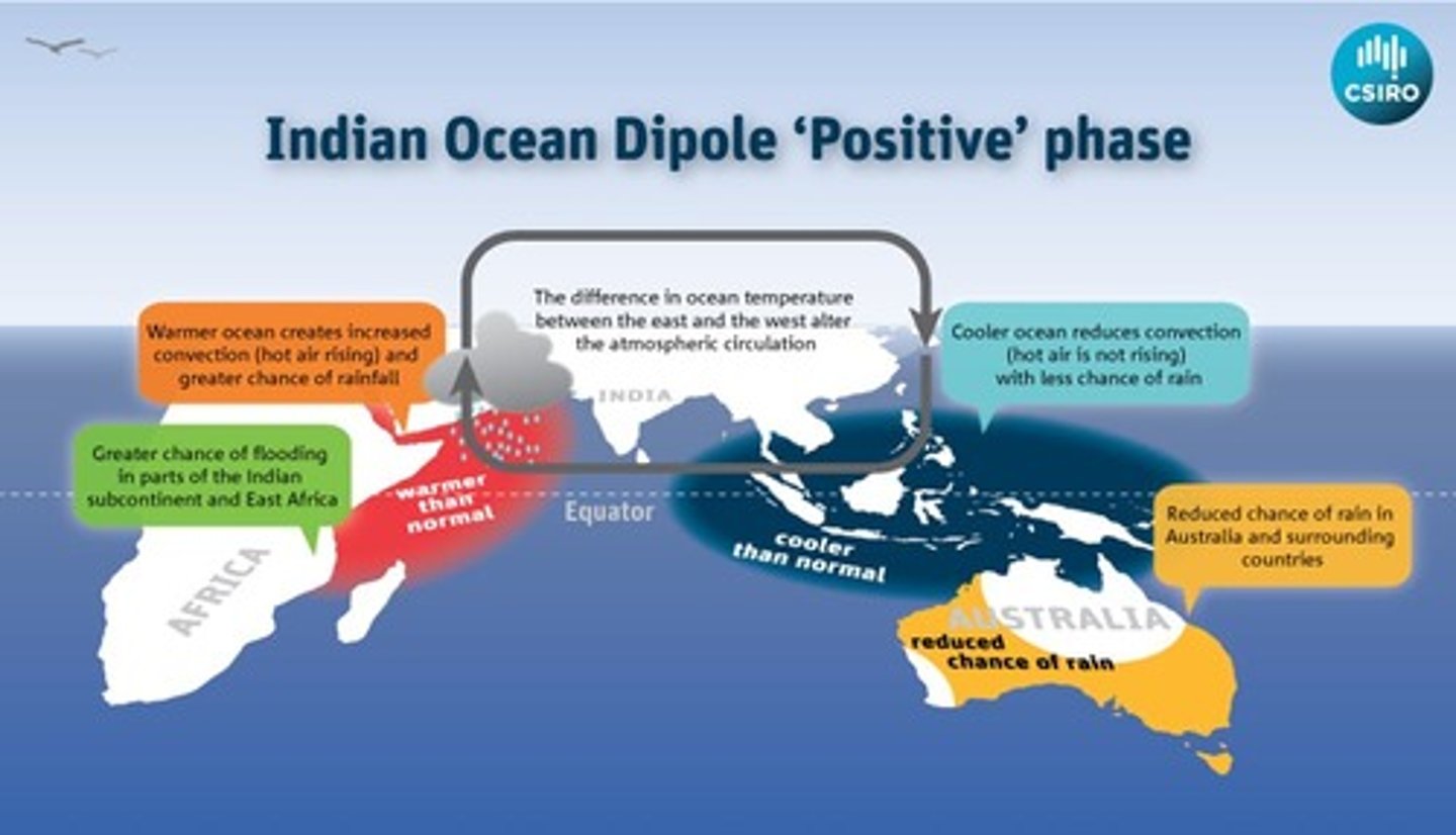
the Indian Ocean Dipole
... also contributed to Australia's Black Saturday wildfire
- IOD = an ocean and atmosphere phenomenon that affects the climate of countries that surround the Indian Ocean basin
- During a positive IOD period, with cooler than normal water in the tropical east and warmer than normal water in the tropical west, there tends to be a decrease in rainfall over parts of central and southern Australia
... therefore increasing risk of wildfires
Predictions of wildfires
... make use of mapping/statistical techniques and focus on the atmospheric and fuel conditions
- Fire danger maps
- Dead fuel moisture/live fuel moisture "greenness" maps
- Drought maps
- Atmospheric stability maps (synoptic weather charts)
- The Haines Index
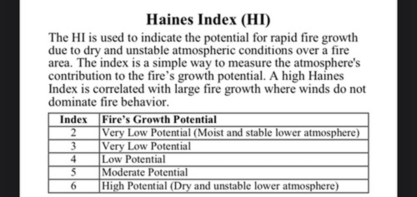
The Haines Index
= a weather index developed by meteorologist Donald Haines in 1988
... measures the potential for dry, unstable air to contribute to the development of large or erratic wild land fires
- Index is derived from the stability (the temperature different between different levels of the atmosphere) and the moisture content (dew point depression) of the lower atmosphere
Haines index of 6 means there is a high potential for an existing fire to become large or exhibit erratic fire behaviour
5 means medium potential
4 means low potential
Anything less than 4 means very low potential
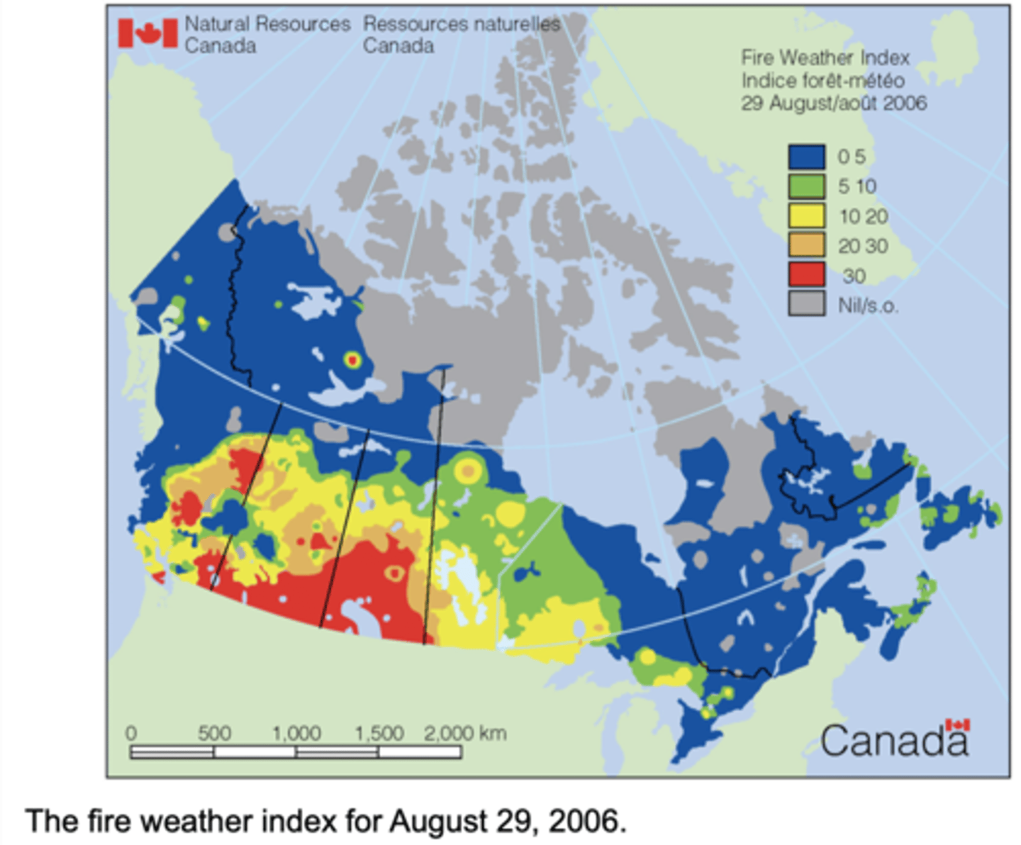
The Fire Weather Index
Indicates fire intensity by combining the rate of fire spread with the amount of fuel being consumed
... calculated using the Canadian Forest Service Fire Weather Index Rating System (FWI)
The higher the FWI, the more favourable the conditions to trigger a wildfire
How fires spread
1. Discarded cigarettes, poorly controlled campfires, etc. ignite a fire
(most common in wildland-urban interfaces - woodland close to urban areas)
2. Heat transfer processes (radiation, conduction, convection) preheat vegetation ahead of the flames preparing them for ignition and rapid spread of fire
... most effective in preheating material above the fire as heat rises, causing advances of the fire front vertically
3. Burning fragments of vegetation (firebrands) can be carried ahead of the fire front by convection currents and strong winds
4. Firebrands ignite isolated spot fires and gravity causes firebrands to roll downslopes to start fires elsewhere away from the front fire
methods of fire spreading
Fire can spread as crown, ground, or spot fires:
Ground fires = spread via dead leaves, twigs and smalls shrubs that catch fire on the ground
Crown fires = where wind spreads the fire through crowns/tops of trees
- Mild crown fires can spread at up to 3m/minute
- Massive crown fires can reach over 100m/minute
Spot fires = where embers of fire fall to the ground
Brush Fire = spreads along low-lying vegetation, moss, and liches
- Trees remain unaffected
(surface fire)
Impacts of wildfires - PRIMARY SOCIAL
Loss of life and injury
Displacement
Disruption to power supplies from strong winds
Damage to mobile phone stations and telephone exchanges affecting communications
Impacts of wildfires - PRIMARY ECONOMIC
Damage/destruction of structures (homes, public buildings, schools, fences, field boundaries)
Financial loss (loss of earnings, damage costs)
Destruction of businesses
Loss of livestock
Impacts of wildfires - PRIMARY ENVIRONMENTAL
Destruction of habitats and ecosystems
Death and injury of animals which impacts on food chains and food webs
Short term surge of CO2 due to the burning of carbon stores (trees)
Atmospheric pollution resulting from smoke and water pollution as toxic ash gets washed into water sources
Impacts of wildfires - PRIMARY POLITICAL
Actions of emergency services
Responses of local and national government (state of emergency status)
Pressure on local authorities and emergency services to coordinate and prioritise response in the immediate aftermath
Impacts of wildfires - SECONDARY ECONOMIC
Costs of rebuilding or possible relocation
Replacement of farm infrastructure, crops, fruit trees, livestock, etc.
Costs of future preparedness and mitigation strategies
Impacts of wildfires - SECONDARY SOCIAL
Possible need for new employment and income stream
Behavioural adaptations based on wildfire experience - people may have to abide by new rules and regulations
Impacts of wildfires - SECONDARY ENVIRONMENTAL
Lack of trees and vegetation causes depletion of nutrient stores, increased leaching, and increased risk of flooding
Increased carbon emissions impact on the greenhouse effect and climate change
Effects on ecosystem development such as secondary succession
Loss of vegetation will affect water cycle, reducing humidity and altering processes of surface runoff, evaporation, and infiltration
Nutrient cycle impacted as biomass and litter stores are burned
Impacts of wildfires - SECONDARY POLITICAL
Develop strategies for preparedness and mitigation
Decisions about replanting forests, compensation, future regulations, etc.
Review laws/advice regarding use of the countryside for leisure
Managing Wildfires
Adaptation = learning to live with the threat
Mitigation = reducing the severity of an event by direct interventions
Pre disaster = Prevention + Preparedness
Disaster = Crisis + Response
Preparedness
1. Community preparedness in the form of early detection and suppression of wildfires is an important element in reducing the spread and the impact of wildfires
(Volunteer firefighters)
2. Warnings released via social media and fire bans introduced when fire risk is high
3. National weather service issue warnings to alert fire departments and residents of critical weather conditions that could lead to increases in wildfire activity
- Red flag warnings issued when weather conditions for extreme fire behaviour may be met within next 24 hours (highest level warning)
- Fire weather watch is used when such weather conditions could exist in the next 24-48 hours
4. Evacuation routes established
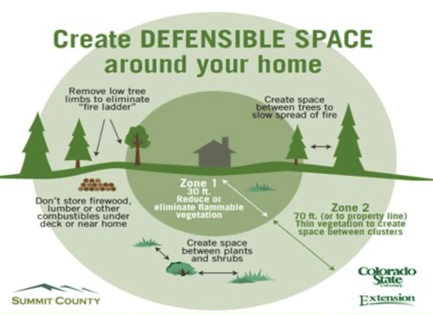
5. People may be able to establish firebreaks or a "defensible space" around their property
e.g.,
- clean roof and gutter
- mow dry grasses and weeds
- remove dead limbs, leaves and other litter
Mitigation
1. Satellites/infrared sensory/cameras can detect thermal variation so fires can be detected early
2. NASA drone technology can survey vast area (e.g., Great Dismal Swamp on Virginia-North Carolina border, USA) fully equipped drones with a 2m wingspan has a range of about 13km and can fly for about an hour
o Can be used to track the spread of wildfires and predicts it path, combined with local meteorological, vegetation, and landscape data to track its spread
e.g.,
UK satellites from ESA provided data on recent Scotland wildfires
USA National Weather Service provides specially trained incident meteorologists to help authorities who are tackling the wildfire, giving weather forecast to help predict fire behaviour
3. Management organisation to manage risk of wildfires
... The Home Office overseas agencies such as:
- The Chief Fire Officers Association (CFOA)
- The England and Wales Wildlife Forum (EWWF)
- The Scottish Wildlife Forum (SWF)
... bodies work together with local agencies to reduce the impact of wildfires
... in the USA national organisations like FEMA (federal emergency management agency) and the US Forest Service work together with state-based department such as the California Department of Forestry and Fire Protection (CAL FIRE) to protect and manage fires
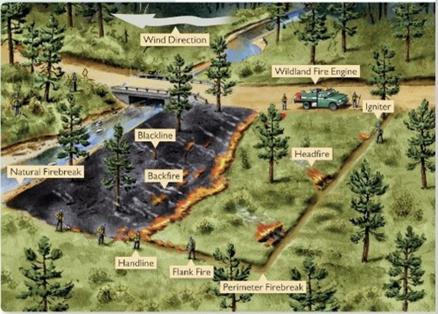
main principles of controlling a wildfire
e.g.,
- removing vegetation
- backburning to control the spread of a fire
- natural fire breakers
- wildland fire engines
- establishing win direction
o Air tankers and helicopters can carry and then drop water and fire retardants to aim to put out the flames
o Smoke jumpers can parachute into affected areas to help fight the fire or Helitack crews can be lowered into the region
o Firefighters work in groups of 20 on the hottest part of the fire, using a range of equipment like chainsaws, bulldozers, etc. to create a fire break
... an area free of flammable materials made around edge of fire zones or in lines through it to take the source of fuel away to limit the ability of the fire to spread
o Fires are named to help fire services track and manage them, as well as raised public awareness of the incident to the public
Management - Disaster Aid
Disaster aid and fire insurance can mitigate the effects of wildfire
e.g., 1983 Ash Wednesday fires in Australia raised AUS$12 million in disaster aid for those affected
Prevention of wildfires
1. Controlled burning can be used to reduce the amount of fuel there is available in a forest but can also become dangerous if they get out of control
... also impact on natural ecosystem and nutrient cycle by reducing litter stores and releasing CO2 into atmosphere
2. Public awareness in campsite and public areas where rules regarding the use of campfires/barbeques have to be strictly enforced
... many countries operate "fire bans" during times of high risk
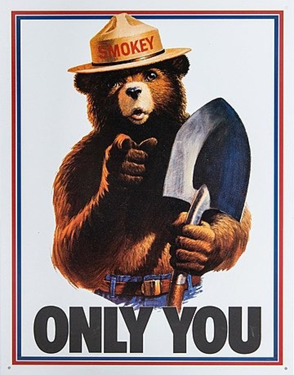
e.g., Smokey Bear (1944)
smokey bear (1944)
... has been used to urge Americans to behave responsibly to fire, with 96% of Americans recognising the icon and 70% recalling his fire safety message
average hectares lost to wildfires annually has fallen from 54 million (1944) to 16.5 million
Adaptation to wildfires
... whilst wildfires play a role in ecosystem development by burning away old and diseased wood, which enables fresh growth + directly stimulates germination of certain species, they can be a threat to human and natural life
1. Planning regulations can be used to reduce the hazard associated with wildfires by restricting access to areas of risk during the fire season
2. Building designs and strategies can be used, with buildings being made out of cheap, simple, natural products that won't cause pollution if they burn down
- Non-combustible building materials, home maintenance to remove leaf debris, waste management removes fuel sources
- Keep gardens healthy as green plants struggle to ignite, use rocky materials in landscape, maintain areas around property, mow lawn
Responses to Black Saturday Wildfires (2009)
Australian government contributed more than AUS$465 million towards reconstruction and recovery
· Also announced a comprehensive recovery assistance package to address the psychosocial, economical infrastructure and environmental impacts
· Assistance was provided to individuals, families, communities, businesses, primary producers, and local governments
· Australian and Victorian governments jointly released the "Rebuilding together: a state-wide plan for reconstruction and recovery" (2009), which granted AUS$193 million to:
- replace major community facilities that were damaged or destroyed in the fires
- support people to rebuild their lives and homes
- kick-start the economic and environmental recovery of these communities