Coasts (AQA Geography A Level)
1/84
There's no tags or description
Looks like no tags are added yet.
Name | Mastery | Learn | Test | Matching | Spaced | Call with Kai |
|---|
No analytics yet
Send a link to your students to track their progress
85 Terms
Fetch
Distance over which the wind blew.
Swash
When a wave breaks, water is washed up the beach and can deposit sediment.
Backwash
Water runs back down the beach and is capable of removing sediment from a beach.
Constructive Waves
Add sediment to the shallow gradient beach and have high swash and low backwash. Longer wavelength, lower height, low wave frequency, and elliptical orbit.
Destructive Waves
Take sediment from the steep beach and have high backwash and low swash. Shorter wavelength, higher height, more frequent wave frequency, and circular orbit.
Sediment Cell
A length of coastline, which is relatively self-contained as far as the movement of sand or shingle is concerned, and where interruption to such movement should not have a significant effect on adjacent ones.
Tides
Regular rising and falling movements of the surface of the sea and caused by the effects of the gravitational pull of the moon and sun on the oceans.
Spring Tides
Sun, moon and earth all in one straight line --> highest high tides and lowest low tides = largest tidal range.
Neap Tides
Sun and moon 90 degrees out of phase --> highest low tides and lowest low tides = smallest tidal range.
Biological Weathering
Weathering from organic agents, e.g. marine animals (secrete acids/clams burrow), land animals (such as rabbits burrowing), birds., plant roots.
Chemical Weathering
Oxidation, carbonation, solution, acid rain.
Mass Movement
Gravity causing downhill movement of material. E.g. Soil creep, mudflows, landslide, rockfall, landslip/slump, runoff, solifluction.
Marine Erosion causes
- Waves (Waves that break at the foot of the cliff cause the most erosion)
- Beaches (sandy beaches have lower gradient than shingle beaches)
- Geology (types of rocks and structures of the rocks)
- Human Activity (defences)
Revetments
Concrete or wooden barriers ('walls') at angles placed along the beach to take the full force of wave energy.
Rock Armour or Rip-Rap
Large boulders dumped in front of a cliff or sea wall to take the full force of the waves. Gabions work on sort of the same way but in metal cages.
Cliff Fixing
Driving iron bars into cliff face to stabilise it and absorb some wave power, sometimes metal mesh netting.
Offshore barriers
Encourage waves to break offshore to reduce their impact on the base of cliffs.
Hard Enginering
Controlled disruption of natural processes by using man-made structures. E.g. Groynes, sea walls, rip rap, revetments, offshore barrier.
Soft Engineering
Use of methods to reduce erosion and achieve stabilisation/safety of coastlines, while enhancing the habitat and saving money. E.g. Beach nourishment, cliff regrading and drainage, dune stabilisation, marsh creation.
Managed Retreat
Abandoning current line of sea defences and then developing the exposed land in some way (possibly salt marshes to reduce wave energy. Newly flooded areas, limited maintenance, attractive wetlands habitats created. Loss of agricultural and residential land, interruption of communications.
Environment Agency
Responsible for around 1400km of over 13,000km of Britain's coastline.
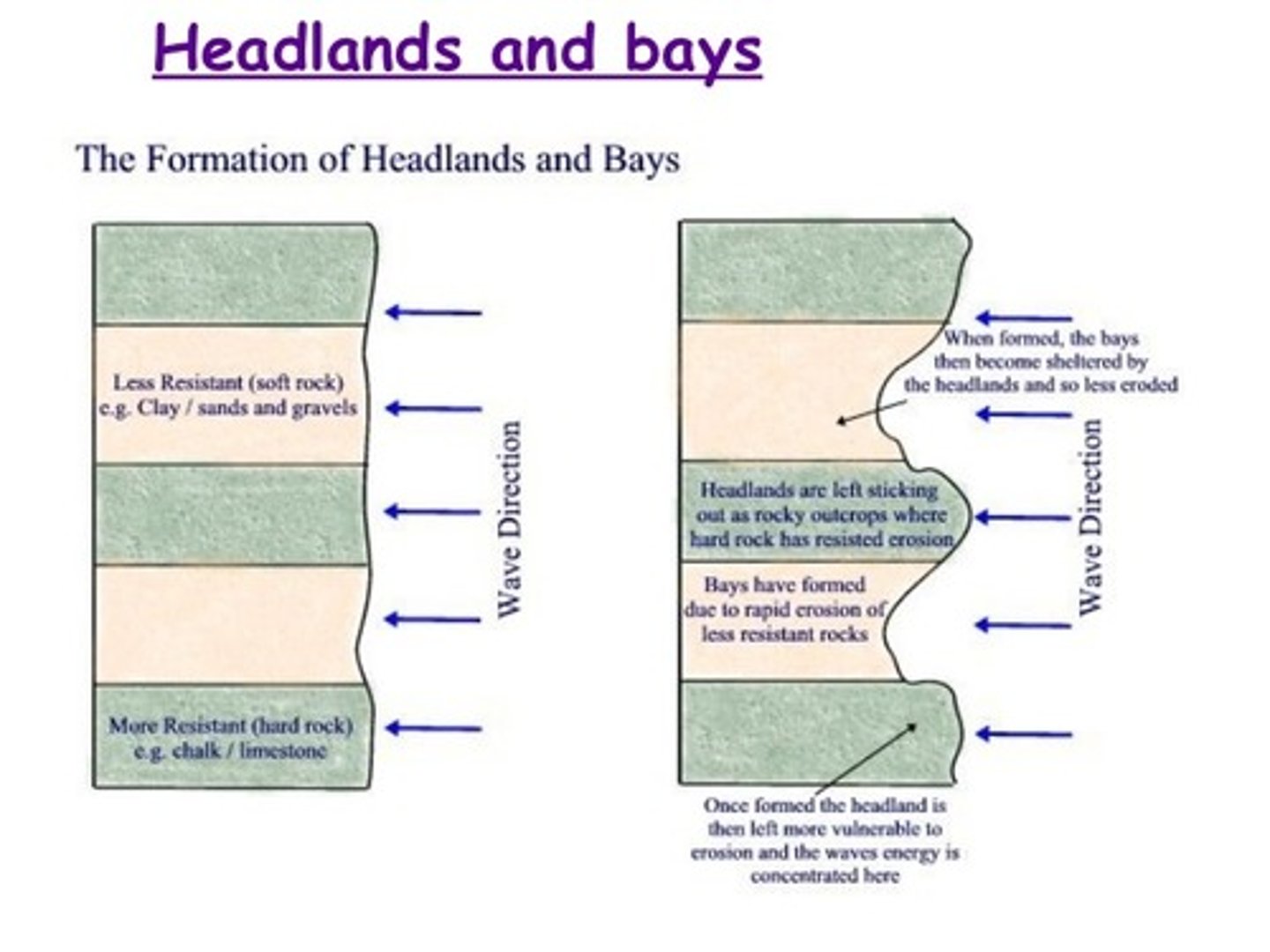
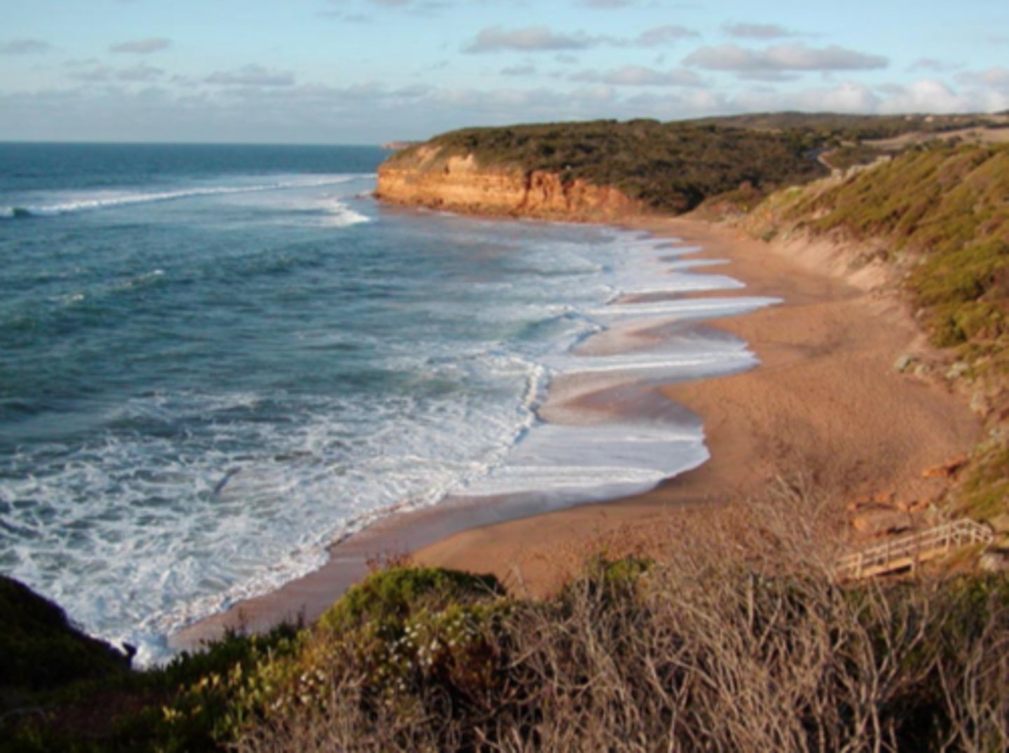
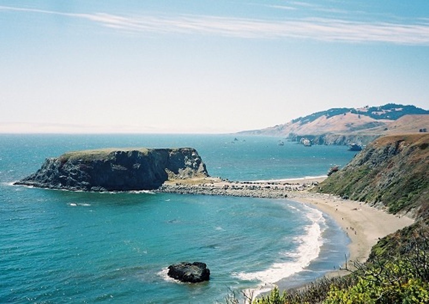
Bays and Headlands
Form due to varying resistances of rocks.
Caves, arches, stacks and stumps
Hydraulic action and abrasion causes crack in cliff which eventually forms cave. Cave widens and deepens until it erodes through to other side of cliff forming an arch. Sub-aerial processes wear away the top of the arch, thinning it over time. Eventually arch collapses, leaving a detached stack. The stack is eroded by hydraulic action so it collapses to form a stump.
Wave-Cut Platforms
Wave-cut notch at the foot of a cliff and as it develops the overlying beds are undermined and eventually collapse.
Offshore bar e.g.
Strong backwash usually leads to these in the sand running parallel to the shoreline at the low-water mark. sediment transported on/off beach e.g Christchurch Bay
Berms
Shingle ridges constructed by swash as tide goes out.
shows in HT
Des waves destroy beach, ridge left
E.g sheringham, norfolk
simple Spit
Long, narrow piece of sand or shingle that has one end joined to the mainland and projects out into the sea or part of the way across an estuary. Longshore drift and wind directions.
Sediment deposited where coast changes direction
E.g. spurn head, humber
Barrier beach
Changes in coast direction. If spit develops to close off an embayment it may create a lagoon which is what this is.
Saltmarshes
Behind spits, areas of mudflats exposed at low tides, vegetation will develop and in time trap more sediment causing growth.. Usually form in estuaries where there is a lot of sediment and it is on a landward side of a spit.
E.g. Hurst Castle.
Sand Dunes
Concentrations of mound-like landforms composed of sand that has blown off the beach by onshore winds. Created by processes of: saltation, LSD depositon/wind direction, and vegetation fixing (MARRAM GRASS). Need: lots of sand, wind, flat area and dry beach.
E.g. Studland.
Isostatic Change
Changes in the land level causes sea level change. E.g. Land height increases --> sea levels fall.
Eustatic Change
Changes in the sea level. Usually due to change in ocean volume.
Fjords
Submergent landform. Drowning of glacial troughs and result in very deep, steep-sided inlets of the sea that typically maintain significant depth for a considerable way inland. E.g. New Zealand
Rias
Submergent landform. Formed when valleys in a dissected upland are submerged. Deep water near the mouth and shallower water inland, with irregular shorelines. Basically land around a river flooded?. E.g. Devon.
Raised Beaches
Emergent landform. Former wave-cut platforms or beach material - now vegetated. Can often see old wave cut notch and fossil sea cave. A small cliff separates raised beach and present beach. E.g. West Scotland.
Dalmatian Coasts
Submergent landform. Rising sea levels cause valleys to flood, often leaving tops of ridges exposed. E.g. Croatia.
Physical weathering
Salt crystallisation, frost shattering, thermal expansion, raindrop impact, wetting and drying.
Hydraulic action
Motion of water against a rock surface produces erosion.
Abrasion
Bits of rock and sand in waves grind down cliff surfaces like sandpaper.
Attrition
Waves smash rocks and pebbles on the shore into each other, and they break and become smoother.
Solution
Acids contained in sea water dissolves some rocks, and then this is carried along in the water.
Suspension
Fine light material is carried along in water.
Saltation
Small pebbles and stones are bounced along the river bed.
Traction
Large boulders and rocks are rolled along the river bed.
Wave quarrying
When waves break against unconsolidated materials, such as sand, they can scoop out loose material.
Cavitation
Vapour bubbles put under pressure in the rock by breaking waves and create an extra force so that the bubble implodes, becoming liquid, giving off various forms of energy that blast apart the rock.
Longshore drift
Swash moves sediment along the beach and the backwash, under gravity, pulls the material back down the beach at right angles to the coastline.
Drift-aligned beach
Sediment is transferred along the coast by longshore drift.
Swash-aligned beach
Sediment moves up and down the beach with little lateral (left/right) transfer.
Shoreline Management Plan (SMP)
Detailed documents for a sediment cell that talks about the intervention needed. They are an approach to coastal management that involves all stake-holders in making decisions about how coastal erosion and coastal flood risk should be managed.
Hold the line
Maintaining the current position of the coastline, usually by hard-engineering methods. Cheap but requires constant maintenance.
Advance the line
Extending the coastline out to sea, can be done by beach nourishment and groyne construction. Protects natural habitats but can be expensive and look unnatural.
No active intervention
Letting nature take its course and allowing the sea to erode cliffs and flood low-lying land and allowing existing defences to collapse. Cost free but land that could have homes and farmland on it is lost.
Integrated Coastal Zone Management (ICZM)
A process for the management of the coast using an integrated approach, regarding all aspects of the coastal zone, including geographical and political boundaries, in an attempt to achieve sustainability. I.e. Lots of areas join together rather than just one area acting alone like with SMP.
Barrier islands
Where parts of a barrier beach break apart from others to leave little parts.
Tombolo
Longshore drift causes an island to become joined to the mainland. A spit grows out from the mainland, which is due to the shape of the headland changing.
UK isostatic/eustatic change
North and West rising due to isostatic recovery --> sea levels falling. South and West sinking as rivers pour water sediment into Thames and English channel --> crust sinks --> sea levels rise --> more floods.
Positive feedback
Where a flow/transfer leads to increase or growth.
Negative feedback
Where a flow/transfer leads to decrease or decline..
Landform
Individual component of a landscape.
Waves
Caused by wind. Size depends on fetch, wind strength and wind duration.
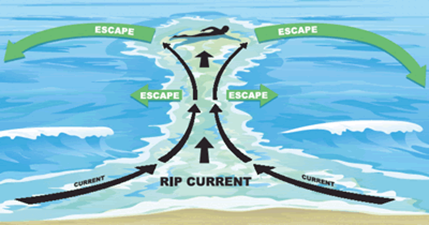
Rip currents
A rush of water that flows rapidly back to sea through a narrow opening in a sandbar. Speeds of 5 mph. 2-3 ft high waves. Calm days after storm. Need breaking waves, pier, or groynes.
Low energy coast
More deposition than erosion. Not powerful waves. Beaches and spits. E.g. Lincolnshire.
High energy coast
More erosion than deposition. Powerful waves. Headlands, cliffs and wave-cut platforms. E.g. Cornwall.
Weathering
Breakdown of rock 'in situ' or close to ground.
Recent sea level change
Last 10,000 years has been a period of global sea level rise following the end of the last glacial period. Some coastlines have experienced a rise in sea level whilst others have experienced a fall.
Beach zones
Offshore --> Nearshore --> Foreshore --> Backshore
UK ice coverage
Line from Cardiff to London but went about 10,000 years ago.
Predicted /recent changes
By 2100, sea levels rise by 30-100 cm
Between 1880-2010 global temps. rose by around 0.85 degrees celcius.
London casestudy
Risk of severe flooding. Building sea defences to stop damage to capital. Large Thames barrier needs replacing but expensive. Sinking due to sediment weighing down Thames and English channel.
Maldives casestudy
Risk of severe flooding and high powerful storm surges. Threatens biodiversity, economy and tourism.Pollutes fresh water supplies, and badly affects fishing.
Hold the line example
Sandbanks ferry slipway --> recharging beach to maintain access
Advance the line example
West cliff and Poole doing in future by 2105 --> have more control
Managed retreat example
Hamworthy common and Brownsea island --> will be controlled and maintained
No active intervention example
Holes Bay in future --> gain more animals habitats
Sundarbans of Bangladesh
South Bangladesh, next to Bay of Bengal. 1000km^2 coastal zone. Mangrove forests and swamps, these sustain local populations. Dense network of interconnecting river channels. Monsoon washes sand into banks to create dunes.
Sundarbans risks
Flooding. Cyclones. Fragile environment. Human-eating endangered Royal Bengal tigers. Resource exploitation. Harmful fishing. Wetlands being turned into farms.
Sundarbans resilience
Mangrove forests protect from storms, floods, tsunamis and erosion. Flooded areas used for fishing, gathering crustaceans or timber. 1 hectare of forest is more than $12,000, this can stop poverty and is good for sustainable development.
Sundarbans mitigation
Significant investment in infrastructure. Creates greater economic safety net. Not working as well now due to less resources, degrading ecosystems, corruption, land ownership conflict, and more tiger deaths.
Sundarbans adaptation
Increasing risks, adaptation more difficult. Floodwater not draining --> farmers learning new methods --> 30,000 people received farm training. Educating people for awareness of risks. New salt-tolerant rice. Built multipurpose cyclone shelters, currently schools. Toilets on higher ground. Installing storage tanks for rainwater --> can drink.
Hengistbury Head
Long groyne at end due to LSD --> caused problems further down coast e.g. Barton on sea. Building more groynes helped reduce erosion as well, and formed beach cusps.
Barton on sea
Holding the line. Have groynes, rip rap, beach nourishment, revetments. + Property saved, more tourism, park/beach huts protected. - Costly, needs maintenance, some properties lost.
Sudden storms will cause problems. Properties not allowed to park next to cliff.
Hurst Castle Spit
1.5 miles long. Salt marsh formed behind. Maintained by regular shingle top-up --> still shrinking. Salt marsh eroded by 3m per year. Protected by rip rap, and revetment.
Old Harry rocks
Cave arches and stack. Small wave-cut platform, and a headland.. Biological weathering (plants and animals), and hydraulic action.
Studland
Saltation forms sand dunes and vegetation fixes it in place.
Has marram grass, heather, moss and dandelions.
Regenerate dunes by replacing sand.
Managed retreat --> old protection broken but not being removed. Need lots of maintenance.