HASS Y9 Term 3
0.0(0)
Studied by 0 peopleCard Sorting
1/84
Earn XP
Last updated 4:37 AM on 8/7/23
Name | Mastery | Learn | Test | Matching | Spaced | Call with Kai |
|---|
No analytics yet
Send a link to your students to track their progress
85 Terms
1
New cards
Scale
Different perspectives and scopes
Global Warming is on a global scale (activity)
Watering your garden on local scale
Global Warming is on a global scale (activity)
Watering your garden on local scale
2
New cards
lithosphere
solid part of the earth’s crust, consisting of rocks and soil
3
New cards
Atmosphere
layers of gas surrounding the Earth
4
New cards
Structure
what makes up an ecosystem, the function
5
New cards
Dynamics
energy flow through system
6
New cards
Ecosystem
self-sustaining system of living organisms which interact with each other and the non-living components of the environment
7
New cards
Biotic factors
living components of an ecosystem
8
New cards
Abiotic factors
non-living components such as air, soil, and rocks
9
New cards
Autotrophs
self-feeding
10
New cards
Heterotrophs
consumers
11
New cards
Saprotrophs
decomposes
12
New cards
Components of an ecosystem
Biotic components: autotrophs, heterotrophs, saprotrophs
Abiotic: air, water, wind, soil, rocks, etc.
Abiotic: air, water, wind, soil, rocks, etc.
13
New cards
how do the 4 spheres interact?
energy (heat) + materials → flow through the atmosphere, lithosphere, and hydrosphere → supports the biosphere by creating the perfect conditions for life
14
New cards
Aquatic
in water
15
New cards
Terrestrial
on land
16
New cards
biome
A biome is a biogeographical unit consisting of a biological community that has formed in response to the physical environment in which they are found and a shared regional climate.
17
New cards
Biome vs. Ecosystem
Biomes are bigger. biomes are characterised by dominant vegetation while ecosystem is by interaction of different species.
18
New cards
tundra (detailed)
* north of the equator
* low temperatures
* high wind
* permafrost
* 150 - 250 ml of rain a year
* 18 to -40 degrees
* scarce vegetation
* animals have many adaptations to climate
* mainly mamals
* birds are migratory
* little insects
* hibernation, thick pelts, large body mass
* soil frozen due to permafrost
* low nutrients
* example - Russia
19
New cards
tropical forest (detailed)
* dominant vegetation trees
* tall trees form canopy
* despite high sun and wind
* lower level forest has smaller trees and moss
* around equator
* example amazon
* 21 - 30 degrees, can get higher
* 750 - 1500 ml of rain a year
* soils are infertile due to frequent rain leaching nutrients deeper
* decomposing plants are used as nutrients
* many animals due to large amounts of flora
* primary adaptation is camouflage
20
New cards
temperate forest (detailed)
* 4 seasons
* 30 to - 30 degrees
* 10 degrees average
* continous canopy of broad leaved trees
* such as oak, maple, chestnut
* high biodiversity
* 750 - 1500 ml of rain a year
* shallow with hard rock near the surface
* small plants on the floor
* grow in spring
* thick bark on trees to survive winter
* example: pacific temperate forests
21
New cards
savannah grasslands (detailed)
* Animals including elephants, giraffes, lions and cheetahs make their homes in the savanna
* . Due to its open environment, camouflage and mimicry are essential for animal survival in the savanna.
* Savannas have extreme wet seasons and dry seasons.
* Due to this lack of precipitation, it is very difficult for large plants like trees to grow in savannas.
* While savannas are located on six of the seven continents, the largest are found in equatorial Africa.
* key vegetation is small shrubs and trees
22
New cards
temperate grasslands (detailed)
* 500 to 900 millimeters
* generally open and continuous, fairly flat areas of grass
* The height of grass correlates with the amount of rainfall it receives
* average temperatures are about -20°C to 30°C
* Temperate grasslands have cold winters and warm summers with some rain
* The grasses die back to their roots annually and the soil and the sod protect the roots and the new buds from the cold of winter or dry conditions.
* A few trees may be found in this biome along the streams, but not many due to the lack of rainfall.
23
New cards
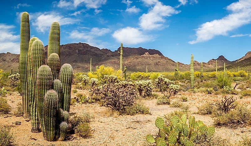
desert (detailed)
* A layer of soil that can either be sandy, gravelly, or stony
* at most 50 centimeters (20 inches) of rainfall a year
* organisms that live in deserts are adapted to this extremely dry climate.
* Plants in deserts have adaptations to conserve water.
* at most 50 centimeters (20 inches) of rainfall a year
* organisms that live in deserts are adapted to this extremely dry climate.
* Plants in deserts have adaptations to conserve water.
24
New cards
alpine (detailed)
* ecosystem that doesn’t contain trees due to its high altitude.
* found in mountainous regions across the globe. Their elevation normally ranges between 10,000 feet (3,000 meters) and the area where a mountain’s snow line begins.
* only about 200 plant species, as their dynamic conditions are not favorable for plant growth
* characterized by cold and windy conditions, as well as harsh sunlight
* extreme temperatures and low humidity.
* high elevation and low precipitation
* temperatures can typically drop from warm to freezing within a day.
* 30 cm) of precipitation annually. Nevertheless, snow may remain on the ground for an extended period, thanks to the consistently low temperatures.
* The soil found in alpine biomes is usually nutrient-poor and acidic. It is mainly made up of rocks and minerals that have been broken down by bacteria. In the winter months, the soil freezes and becomes covered in a layer of frost.
* characterized by small groundcover plants
25
New cards
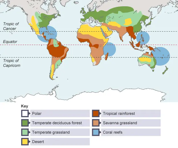
spatial distribution
Spatial distribution is the arrangement of a phenomenon across the Earth's surface
26
New cards
spatial distribution of biomes
\
27
New cards
climate
Climate refers to the average weather conditions of a specific location over an extended period of time. A location’s climate consists of:
The temperature of an area.
The amount of precipitation of an area
The temperature of an area.
The amount of precipitation of an area
28
New cards
biome
a biome is a large area/landmass with similar flora and fauna and a common climate.
29
New cards
weather
Weather refers to the short-term conditions of the atmosphere, i.e. the specific weather conditions being experienced at one moment in time
30
New cards
distribution of biomes
The distribution of biomes is influenced by factors such as climate, topography, and soil conditions.
Biomes are large-scale ecological communities characterized by distinct vegetation and animal life.
Some major biomes include tropical rainforests, deserts, grasslands, temperate forests, and tundra.
The distribution of these biomes is determined by factors like temperature, precipitation, and latitude. For example, tropical rainforests are found near the equator where it is warm and receives high rainfall, while deserts are typically found in areas with low precipitation and high temperatures.
The specific distribution of biomes can vary globally and within regions due to local conditions and human activities.
31
New cards
koppen system of classification
divides climates into five main climate groups, with each group being divided based on patterns of seasonal precipitation and temperature.
32
New cards
5 categories of biomes (according to KSC scheme 1)
**A - Tropical – Exceeds 18C and significant rainfall**
**B - Arid/Dry - Low rainfall**
**C - Temperate – At least one month is between 0-18C and at least one month in which the average temperature exceeds 10C**
**D - Continental – At least one month averaging below 0C**
**E - Polar - Every month of the year with an average temperature below 10 °C.**
**B - Arid/Dry - Low rainfall**
**C - Temperate – At least one month is between 0-18C and at least one month in which the average temperature exceeds 10C**
**D - Continental – At least one month averaging below 0C**
**E - Polar - Every month of the year with an average temperature below 10 °C.**
33
New cards
subcategories according to KSC
each letter (apart from E) is assigned a subcategory based on precipitation and temperature
34
New cards
scheme 2 of KSC
w - dry winter
f - no dry season
s - dry summer (can apply to anything but polar)
f - no dry season
s - dry summer (can apply to anything but polar)
35
New cards
scheme 3 of KSC
h (Hot) (only dry)
k (Cold) (only dry)
a (Hot summer)
b (Warm summer)
c (Cold summer) \\n d (Very cold winter) (only temperate or continental)
T (Tundra) (only polar) \\n F (Ice cap) (only polar)
no TROPICAL
k (Cold) (only dry)
a (Hot summer)
b (Warm summer)
c (Cold summer) \\n d (Very cold winter) (only temperate or continental)
T (Tundra) (only polar) \\n F (Ice cap) (only polar)
no TROPICAL
36
New cards
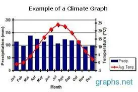
climate graph
* displays yearly temperature and precipitation statistics for a particular location
* Temperature (C) is measured using the numbers on the left hand side of the chart.
* The average temperature for each month is plotted on the graph with a red dot and the dots are then connected in a smooth, red line.
* precipitation is shown as a bar graph with the amount of precipitation each month
* precipitation - blue
* temperature - red
* x axis is time over a year
* y axis is number / amount
37
New cards
climate graph purpose
to illustrate the average temperature and rainfall experienced at a particular place over the course of a year.
38
New cards
example of a climate graph
39
New cards
6 factors that influence climate
L - latitude
A - altitude
P - prevailing winds
D - distance from sea
O - ocean currents
G - geographic barriers
A - altitude
P - prevailing winds
D - distance from sea
O - ocean currents
G - geographic barriers
40
New cards
acronym for things that influence climate
LAPDOG
41
New cards
altitude (detailed)
* measure of height above sea level
* the higher above, the lower the temperature
* this is because of decreased air pressure, which means particles are further apart, and because of that heat energy is lost
* 1000 metres above sea level - falls 6.5 degrees
* the higher above, the lower the temperature
* this is because of decreased air pressure, which means particles are further apart, and because of that heat energy is lost
* 1000 metres above sea level - falls 6.5 degrees
42
New cards
prevailing winds (detailed)
* wind patterns over specific region
* carry climate of area they came from
* two patterns are
* prevailing trade winds (tropical)
* prevailing westerlies (subpolar)
* winds from cooler places = cooler climate
* winds from warm places = warmer climate
* carry climate of area they came from
* two patterns are
* prevailing trade winds (tropical)
* prevailing westerlies (subpolar)
* winds from cooler places = cooler climate
* winds from warm places = warmer climate
43
New cards
distance from ocean (detailed)
* ocean has more consistent temperature than land, as it takes longer to change temperature
* coastal locations have more temperate season climates
* less temperature fluctuation between day and night
* coastal locations have more temperate season climates
* less temperature fluctuation between day and night
44
New cards
ocean currents (detailed)
* continuous and directed movement of ocean water through the earth
* carry hot or cold water from one area of the world, which affects the climate of those regions
* warm ocean currents:
* increase temperature
* increase rainfall
* cold ocean currents:
* lower temperature
* lower rainfall
* example: cities in america/europe along the same latitude can have varying temperatures due to different ocean currents
45
New cards
geographic barriers (detailed)
* mountains can affect rainfall by creating barriers for passing clouds and rainfall
* force moist air to rise, which causes air to cool and condense, creating rain
* windward side of the mountain receives most of the rainfall, and other side receives less rainfall (dry and hot)
* force moist air to rise, which causes air to cool and condense, creating rain
* windward side of the mountain receives most of the rainfall, and other side receives less rainfall (dry and hot)
46
New cards
Perth climate
\
* temperate mediterranean climate characterised by hot, dry summers and cool, wet winters
* receive around 700 mm of rainfall a year
* temperature ranges from 7 - 32 (winter summer)
* 30 degrees south
* located south of the tropic of capricorn, outside tropical belt
* creates temperate climate between tropical and subpolar (mild temperature and rainfall)
* at sea level no mountain ranges
* no significant altitude based temperature range
* higher rainfall levels at the foot of the darling ranges
* flat apart from DR, rainfall spread evenly
* prevailing winds in perth are seasonal
* strong westerlies during winter bring antarctic air
* dry air comes from inland
* every day in summer, breeze from the ocean called Fremantle Doctor cools perth by upto 10 degrees
* occurs because of the pressure difference between land and sea
* receives cool ocean currents from antarctica (WA Current)
* keeps climate mild in summer and wet during winter, and a dry weather climate rather than humid
47
New cards
Space
How areas are used and organised on the earth
48
New cards
Place
Where something is located
49
New cards
Interconnection
How people and things are connected to other people and things.
Example: Factory gives jobs to people but pollutes places
Example: Factory gives jobs to people but pollutes places
50
New cards
Change
Perth has more buildings and roadworks, and population compared to before.
51
New cards
Environment
Living and non-living features of a particular part of the earth.
Non-Living: Water, Footpaths, Bridges, Buildings, Statues, Rocks
Living: Plantation, Human, Birds Fish, Snakes, Ducks, Trees
Non-Living: Water, Footpaths, Bridges, Buildings, Statues, Rocks
Living: Plantation, Human, Birds Fish, Snakes, Ducks, Trees
52
New cards
Sustainability
How long we are able to sustain a particular object or an event for the future generation.
Building buildings may not be sustainable for the future and resource use.
Building buildings may not be sustainable for the future and resource use.
53
New cards
Colombian Amazon Rainforest - **Insolation & Climate**
* Abiotic Factor
* Humid and Warm
* E.G. Temperatures usually average 27.9 °C during the dry season, and 25.8 °C during the rainy season. Relative humidity is quite high at an average of 88% in the rainy season and 77% in the dry season.
* Humid and Warm
* E.G. Temperatures usually average 27.9 °C during the dry season, and 25.8 °C during the rainy season. Relative humidity is quite high at an average of 88% in the rainy season and 77% in the dry season.
54
New cards
Colombian Amazon Rainforest - **Rocks**
* Abiotic Factor
* Pre-Cambrian and Bauxite
* The Amazon basin is formed by the depression of pre-Cambrian bedrock and is surrounded on three sides by the Andes to the West, and the Brazilian and Guyana shields to the South and North, respectively. The earth of this basin is made up of sedimentary layers of soft clay and sand deposits over 13,000 feet (4,000 m) thick.
55
New cards
Colombian Amazon Rainforest - **Soils**
* Abiotic Factor
* Soil in the rainforest is shallow and low in nutrients, most of the nutrients are being carried in the bodies of the many organisms living in the forest.
* The soil is mostly made up of small particles of rock (sand and clay) mixed with decomposed plants and animals. Plants use the roots to get water and nutrients from the soil.
56
New cards
Abiotic Factors
All the nonliving components of an ecosystem.
57
New cards
Alpine Biomes
Biomes that are found on or at the base of mountains that are characterised by high altitude and cool temperatures.
58
New cards
Altitude
A measurement of height above sea level. As this increases, temperature decreases.
59
New cards
Aquatic Biomes
Biomes that exist in the water, and are one of the two main types of Biomes (e.g. Coral Reefs, Estuaries, Oceans).
60
New cards
Arid Climate
A climate type that is very cold and low-moderate rainfall amounts.
61
New cards
Biodiversity
The variety of plant and animal life living in a particular habitat.
62
New cards
Biome
An area or region that contains similar flora and fauna as a result of having a common climate.
63
New cards
Biosphere
The sphere of the earth containing all living organisms.
64
New cards
Biotic Factors
All the living organisms that inhabit an ecosystem.
65
New cards
Boreal Forest
Dense forest of evergreens located in the upper regions of the Northern Hemisphere.
66
New cards
Climate
The average weather conditions for an area over an extended period of time. It is measured primarily by temperature and rainfall.
67
New cards
Continental Climate
The climate found at the centre of continents, with cold winters and warm summers
68
New cards
Desert Biome
A terrestrial biome characterised by limited wildlife, extreme temperatures, and low (less than 250mm) of rainfall.
69
New cards
Distance from Ocean
A measure of how far a location is from the ocean. Coastal locations have cooler summers and warmer winters due to consistency in ocean temperature.
70
New cards
Geographic Barriers
A physical barriers that limits the movement of air and clouds.
71
New cards
Geosphere
The mostly solid, rocky part of the Earth.
72
New cards
Hydropshere
All of the water on and near Earth's surface including lakes, rivers, streams, oceans, ground water, and ice caps.
73
New cards
Latitude
A measure of distance from the equator (measured in degrees). As this increases, climate tends to get colder.
74
New cards
Ocean Currents
The continuous and directed movement of ocean water around the earth. They impact climate based on the heat of the water of the current.
75
New cards
Polar Climate
A type of climate found in the areas around the north and south pole, where the weather is cold.
76
New cards
Prevailing Winds
Global winds that blow constantly from the same direction, bringing the climate with them.
77
New cards
Savanna Grassland Biome
A terrestrial biome located in tropical and sub-tropical regions that is characterised by moderate rainfall and moderate temperatures. Due to the ideal climate and limited vegetation, it is favoured for agriculture.
78
New cards
Temperate Climate
A mild climate located just outside the tropics with moderate rainfall and temperatures.
79
New cards
Temperate Forest Biomes
A terrestrial biome located in the temperate belt that is characterised by diverse wildlife, high rainfall, and moderate temperatures (e.g. Boranup Forest).
80
New cards
Temperate Grassland Biome
A terrestrial biome located in temperate regions that is characterised by moderate rainfall and moderate temperatures. Due to the ideal climate and limited vegetation, it is favoured for agriculture.
81
New cards
Terrestrial Biomes
Biomes that exist on land, are one of the two main types of Biomes (e.g. Deserts, Forests, Tundra)
82
New cards
Tropical Climate
A type of climate found in the areas just north or south of the equator, where climate is usually hot and wet.
83
New cards
Tropical Forest Biome
A terrestrial biome located near the equator that is characterised by highly diverse wildlife and a consistently warm and wet climate (e.g. Daintree Rainforest).
84
New cards
Tundra Biome
A terrestrial biome located in a polar or mountainous region that is characterised by very sparse wildlife, cold climate, and limited rainfall. Often covered in permafrost (frozen soil). (E.g. Mount Kosciusko).
85
New cards
Woodlands Biome
A biome that is characterised by large tree populations and moderate rainfall and temperature.