2.1 Earthquakes and volcanoes
1/41
There's no tags or description
Looks like no tags are added yet.
Name | Mastery | Learn | Test | Matching | Spaced | Call with Kai |
|---|
No analytics yet
Send a link to your students to track their progress
42 Terms
What is a volcano
opening in the Earth’s crust through which hot molten magma (lava), molten rock and ash are erupted onto the land
Magma
molten materials inside the Earth’s interior
Lava
when molten material is ejected at the Earth’s surface through a volcano or crack
Types of volcano
shield volcanoes - produced by very hot, runny lava
associated with constructive boundaries and hotspots
cone volcanoes - produced by thick material
associated with destructive plate boundaries
chamber
the reservoir of magma located deep inside the volcano
crater
depression at the top of a volcano following a volcanic eruption. may contain a lake
vent
channel that allows magma within the volcano to reach the surface in a volcanic eruption
active volcanoes
those that have erupted in recent times, such as Mt Pinatubo in 1991 and Montessart in 1997, and could erupt again
dormant volcanoes
volcanoes that have not erupted for many centuries, but may erupt again
e.g. Mt. Rainier in the USA
Extinct volcanoes
not expected to erupt again
e.g. Kilimanjaro in Tanzania
What is an earthquake
an earthquake involves sudden, violent shaking of the Earth’s surface
occur after a build-up of pressure causes rocks and other materials to give way.
most of this pressure occurs at plate boundaries when one plate is moving against another.
focus
the place beneath the ground where the earthquake takes place
Deep-focus vs. shallow-focus earthquakes
deep-focus earthquakes are associated with subduction zones.
shallow-focus earthquakes are generally located along constructive boundaries and along conservative boundaries.
epicentre
the point on the ground surface immediately above the focus
what human activities could cause earthquakes
nuclear testing
building large dams
drilling for oil/natural gas
coal mining
The Richter scale
measures the magnitude (strength or force) of earthquakes
measured on a seismometer and shown on a seismograph
logarithmic scale
means that an earthquake of 6.0 is ten times grater than one of 5.0, and one hundred times greater than one of 4.0
the Mercalli scale
relates ground movement to things that you would notice happening around you
its advantage is that it allows ordinary eyewitnesses to provide information on the strength of the earthquake
Distribution of earthquakes
very uneven
mostly along plate boundaries which are regions of crustal instability and tectonic activity
500,000 earthquakes are detected every year
most occur in linear chains along all types of plate boundary
some appear in areas away from plate boundaries, such as in the mid-west of the USA
Distribution of volcanoes
there are over 1300 active volcanoes in the world
many of them are under the ocean
three quarters of the world’s active volcanoes are located in the ‘Pacific Ring of Fire’, the area around the Pacific Ocean
e.g. Mt Pinatubo, Krakatoa
plate tectonics
set of ideas that describe and explain the global distributino of earthquakes, volcanoes, fold mountains and rift valleys.
the cause of earth movement is huge convection currents in the Earth’s interior, which rise towards the Earth’s surface, drag continents apart and cause them to collide
these events happen because the Earth’s interior consists of semi-molten layers (magma), so the crust moves around on the magma
the main plates are: Pacific, Indo-Australian, Antarctic, North American, South American, African and Eurasian
structure of the Earth
there are four main layers
the inner core: solid, 5 times denser than surface rocks
outer core - semi-molten
mantle - semi-molten and about 2900 km thick
crust - solid and is divided into two main types: oceanic and continental. the depth of the crust varies between 10km and 70 km
continental crust is mostly formed of granite, it is less dense than the oceanic crust.
the oceanic crust (more denser) plunges beneath the continental crust when they come together
constructive (divergent) boundaries
the two plates move AWAY from each other
new oceanic crust is formed
volvanic activity is common
destructive (convergent) boundaries
the oceanic cruts moves towards the continental crust and sinks beneath it due to its greater density
deep sea trenches and island arcs are formed
the continental crust is folded into fold mountains
volcanic activity is common
collision zones
two continental crusts collide
as neither can sink they are folded up into fold mountains
plates are folded and crumpled
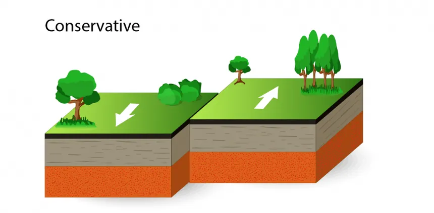
conservative plates
two plates slip sideways past each other but land is neither destroyed nor created
earthquakes can occur
causes of earthquakes
caused by the build-up of pressure that results from plate movement
so many earthquakes are found close to plate boundaries
what is the shit that comes out of volcanoes
many diff. types of material
pyroclastic flows are superhot (700*) flows of ash and pumice moving at speeds of over 500km/hour
cinders are small rocks and coarse volcanic materials
volcanic strength
measured by the volcanic explosive index (VEI)
based on the amount of material ejected in the explosion, the height of the cloud it causes and the amount of damage caused
any explosion above level 5 is considered very large and violent
the scale is logarithmic, so VEI8 is ten times more powerful than VEI7
supervolcanoes
have VEI8
tend to be much larger than normal volcanoes
the likely impacts of a VEI8 eruption include:
almost complete loss of life within about 1000 km of the eruption
destruction of all crops and livestock, leading to a global famine
economic and social devastation
natural hazard
a natural event that causes damage to property and/or disruption to normal life, and may caues loss of life
involve hydrological, atmospheric and geological events
caused by the impact of natural events on the social and economic cenv. in which people live
some groups of people are more vulnerable to them/have greater exposure
since the 1960s, more people have been affected by natural hazards. What are the reasons for this?
a rapid increase in population, especially in developing countries
increased levels of urbanisation, including more shanty towns, which are often located in hazardous env.
changing land use in rural areas, which results in flash floods, soil erosion and landslides
inc. number of people living in poverty who lack the resources to cope w natural hazards
changes in the natural env. causing inc. frequency and intensity of storms, floods and droughts
hazard, disaster, risk
hazard: potentially dangerous event or process
disaster: when the hazard affects people and their proerty
risk: there is possibility of loss of life or damage
risk assessment is the study of the costs and benefits of living in a particular env.
two ways of looking at people’s vulnerability
people choose to live in hazardous env. because they understand the env. people choose to live in an area because they feel the benefits outweigh the risks (wrong)
people live in hazardous env. because they have very little choice over where they live, as they are too poor to move (right)
why are volcanic eruptions useful
some countries were created by volcanic activity
volcanic soils are rich, deep and fertile, allowing intensive agriculture to take place
volcanic areas are imp. for tourism
some areas are seen by people as symbolic and part of the national identity
what affects the extent of earthquake damage
strength of the earthquake and number of aftershocks
population density
type of buildings
time of day
distance from the epicentre of the earthquake
types of rocks and sediments
secondary hazards
`
managing volcanoes
spraying lava flows with water to cool them down and solidify
digging diversion channels to divert lava flows away from settlements
adding ‘cold’ boulders to lava flow in attempt to cool the lava and stop it moving
but if the eruption is a pyroclastic flow, there is little that can be done to prevent the impacts apart from evacuation
predicting volcanoes
main methods:
seismometers, to record swarms of tiny earthquakes that occur as the magma rises
chemical sensors, to measure increased sulfur levels
lasers, to detect the physical swelling of the volcano
measurement of small-scale uplift or subsidence, changes in rock stress and changes in radon gas concentration
ultrasound, to monitor low-frequency waves in the magma, resulting from the serge of gas and molten rock
how do people cope with earthquakes
three basic options
do nothing and accept the hazard (LMAO???)
adjust to living in a hazardous env. - strengthen the home
leave the area
how to deal with earthquakes
better forecasting and warning
building design, location and emergency procedures
how to predict and monitor earthquakes
measuring crustal movement - small-scale movement of plates
recording changes in electrical conductivity
noting strange and unusual animal behaviour, e.g. among carp (fish)
checking historical evidence - there are possibly trends in the timing of earthquakes in some regions
building design for earthquakes
a single-story building responds quickly to earthquake forces.
high-rise building responds slowly and shock waves are increased as they move up the building
if buildings are too close together, vibrations may be amplified b/w buildings and increase damage
weakest part of the building is where diff. elements meet
elevated motorways are vulnerable in earthquakes bc. they have many connecting parts
certain areas are at risk from earthquake damage - areas with weak rocks, broken rocks and soft soils
many oil and water pipelines in tectonically active areas are built on rollers so that they can move with earthquake rather than fracture
safe houses
safe houses can be built cheaply using straw, adobe or old tyres
e.g. in India, a concrete house reinforced with bamboo has been successfully tested by researchers