Private Pilot Book Exam 3 - Airspace and Airport Operations
1/143
There's no tags or description
Looks like no tags are added yet.
Name | Mastery | Learn | Test | Matching | Spaced | Call with Kai |
|---|
No analytics yet
Send a link to your students to track their progress
144 Terms
122.9 MHz
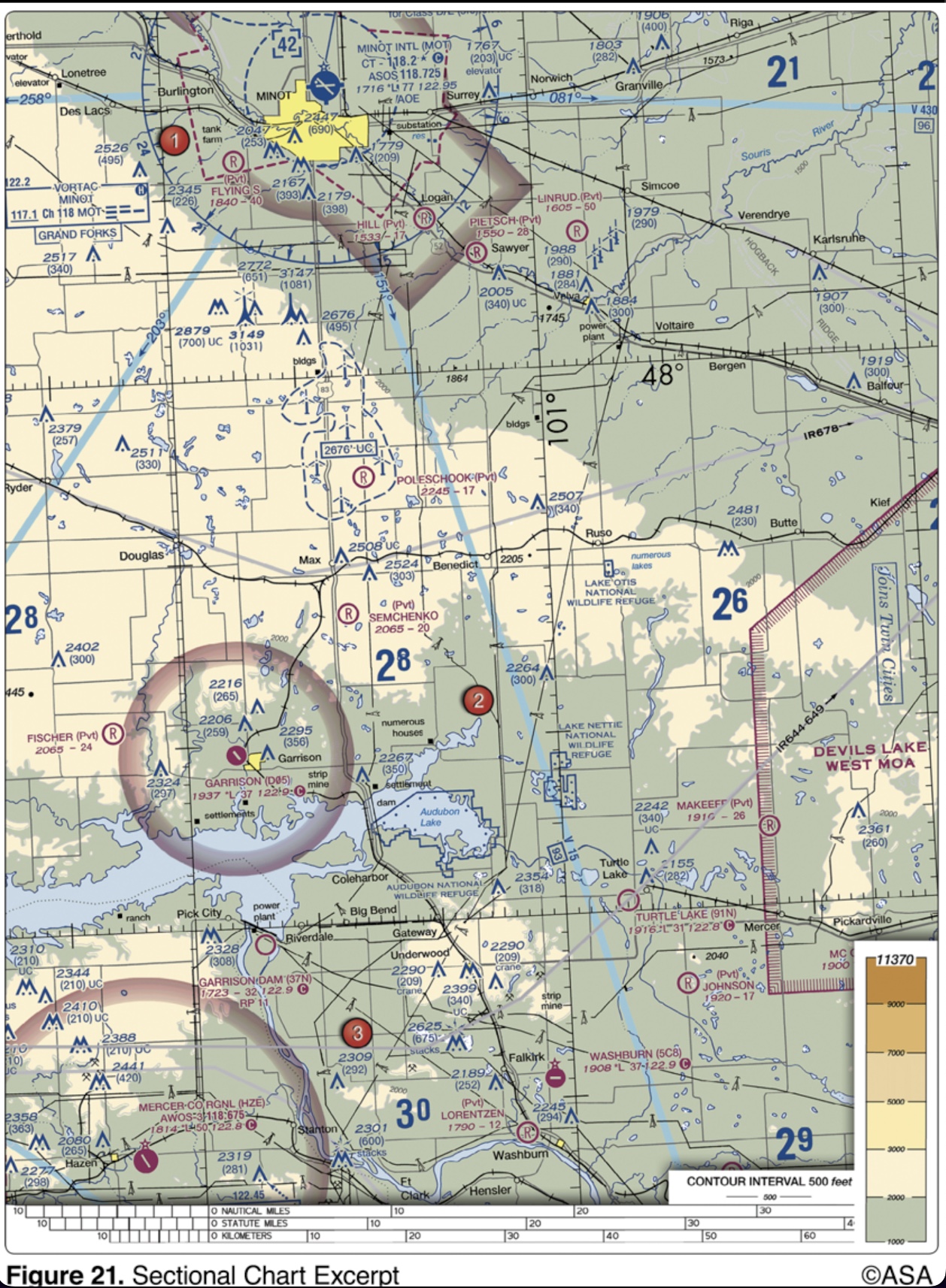
(Refer to Figure 21, area 2.) The CTAF/MULTICOM frequency for Garrison Airport is
green, yellow, and white rotating beacon
A lighted heliport may be identified by a
private pilot certificiate or student pilot certificate with appropriate logbook endorsements
What minimum pilot certification is required for operation within Class B airspace?
10 miles
As standard operating practice, all inbound traffic to an airport without a control tower should continuously monitor the appropriate facility from a distance of
1,200 feet AGL to 17,999 MSL
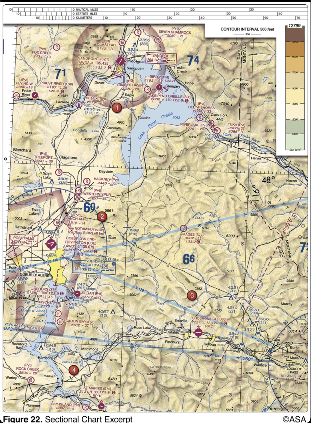
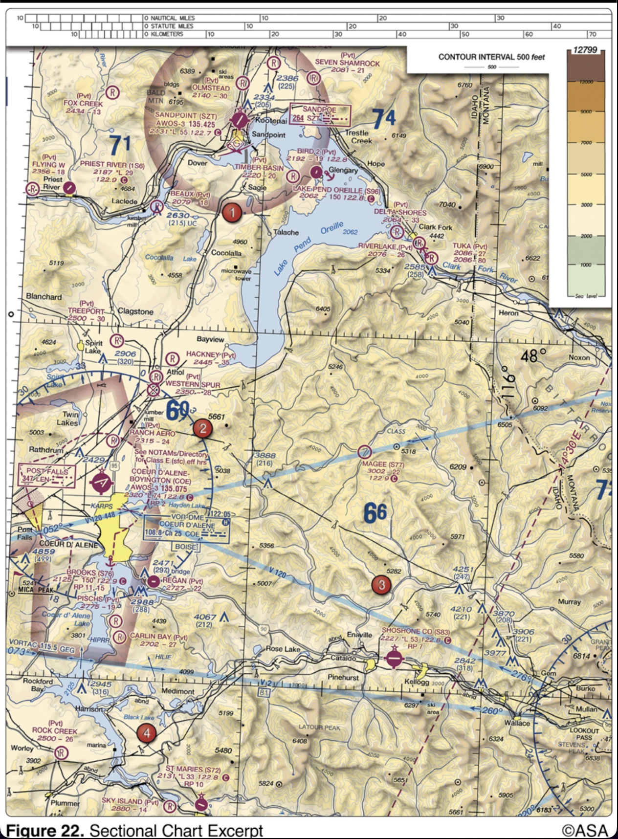
(Refer to Figure 22, area 3.) The vertical limits of that portion of Class E airspace designated as a Federal Airway over Magee Airport are
aileron up on the side from which the wind is blowing
Which aileron positions should a pilot generally use when taxiing in strong quartering headwinds?
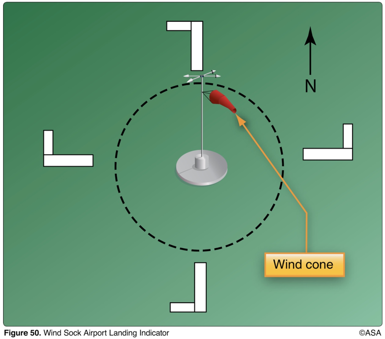
left-hand traffic on runway 36
(Refer to Figure 50.) Which runway and traffic pattern should be used as indicated by the wind cone in the segmented circle?
080° and 260° magnetic
The numbers 8 and 26 on the approach ends of the runway indicate that the runway is orientated approximately
cannot be used for landing, but may be used for taxiing and takeoff
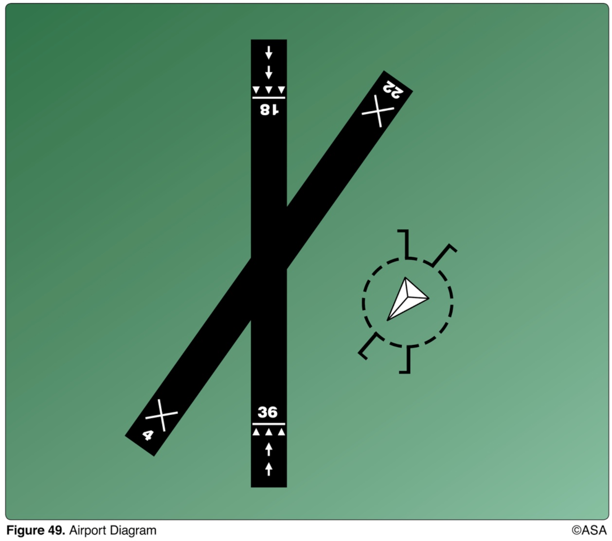
(Refer to Figure 49.) The arrows that appear on the end of the north/south runway indicate that the area
noncontrol information in selected high-activity terminal areas
Automatic Terminal Information Service (ATIS) is the continuous broadcast of recorded information concerning
Class G airspace—surface up to but not including 1,200 feet AGL, Class E airspace—1,200 feet AGL up to but not including 18,000 feet MSL
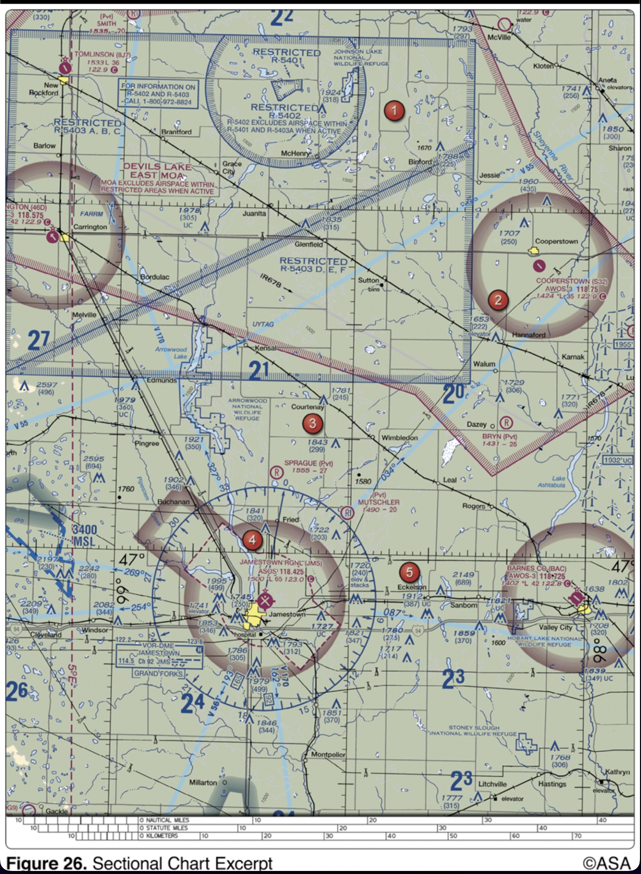
(Refer to Figure 26, area 1.) Identify the airspace over Tomlinson Airport.
the same as during daytime
VFR approaches to land at night should be accomplished
dual peaked (two quick) white flashes between green flashes
How can a military airport be identified at night?
1,200 feet above the surface up to and including 17,999 feet MSL
Unless otherwise specified, Federal Airways include that Class E airspace extending upward from
exercise extreme caution when military activity is being conducted
What action should a pilot take when operating under VFR in a Military Operations Area (MOA)?
Chat Supplements U.S.
Information concerning parachute jumping sites may be found in the
primary airport’s control tower
A non-tower satellite airport, within the same Class D airspace as that designated for the primary airport, requires radio communications be established and maintained with the
Class E
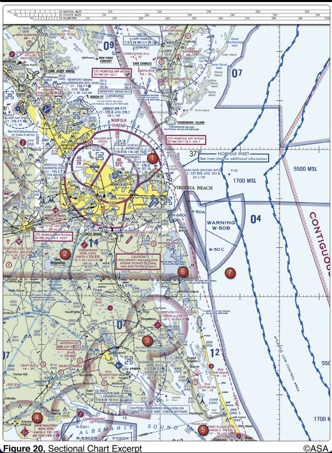
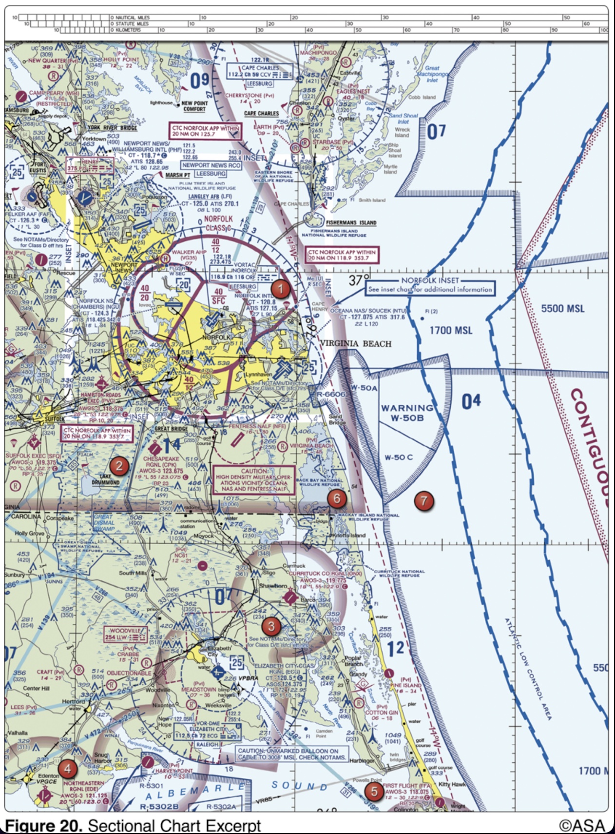
(Refer to figure 20, area 1.) The NALF Fentress (NFE) Airport is in what type of airspace?
at all tower controlled airports regardless of weather conditions
Unless otherwise authorized, two-way radio communications with Air Traffic Control are required for landings or takeoffs
2,000 feet AGL
Pilots flying over a national wildlife refuge are requested to fly no lower than
123.05 and 123.075 MHz
Select the UNICOM frequencies normally assigned to stations at landing areas used exclusively as heliports.
an aircraft equipped with a 4096-code transponder with Mode C encoding capability
All operations within Class C airspace must be in
return to the starting point on the airport
A flashing white light signal from the control tower to a taxiing aircraft is an indication to
steady red
If the control tower uses a light signal to direct a pilot to give way to other aircraft and continue circling, the light will be
two-way radio communication equipment, a 4096-code transponder, and an encoding altimeter
What minimum radio equipment is required for operation within Class C airspace?
Class A
In which type of airspace are VFR flights prohibited?
longitudinal axis of the aircraft parallel to the direction of its motion
To minimize the side loads placed on the landing gear during touchdown, the pilot should keep the
20 NM
The radius of the procedural Outer Area of Class C airspace is normally
126.0 MHz
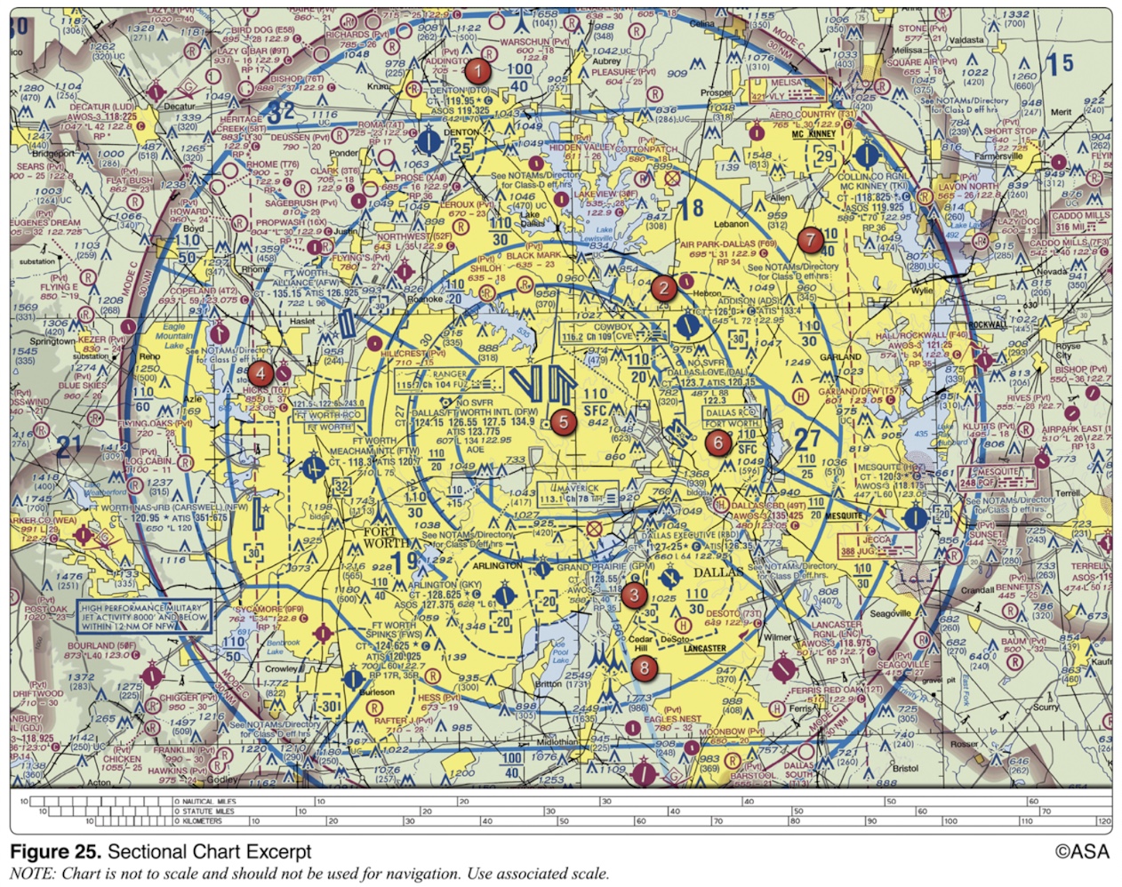
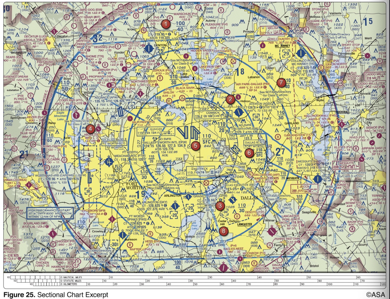
(Refer to Figure 25, area 2.) The control tower frequency for Addison Airport is
18,000 feet MSL
With certain exceptions, Class E airspace extends upward from either 700 feet or 1,200 feet AGL to, but does not include,
maintain an altitude at or above the glide slope until a lower altitude is necessary for a safe landing
While operating in Class D airspace, each pilot of an aircraft approaching to land on a runway served by a visual approach slope indicator (VASI) shall
left-hand for Runway 36 and right-hand for Runway 18
(Refer to Figure 50.) The segmented circle indicates that the airport traffic is

G
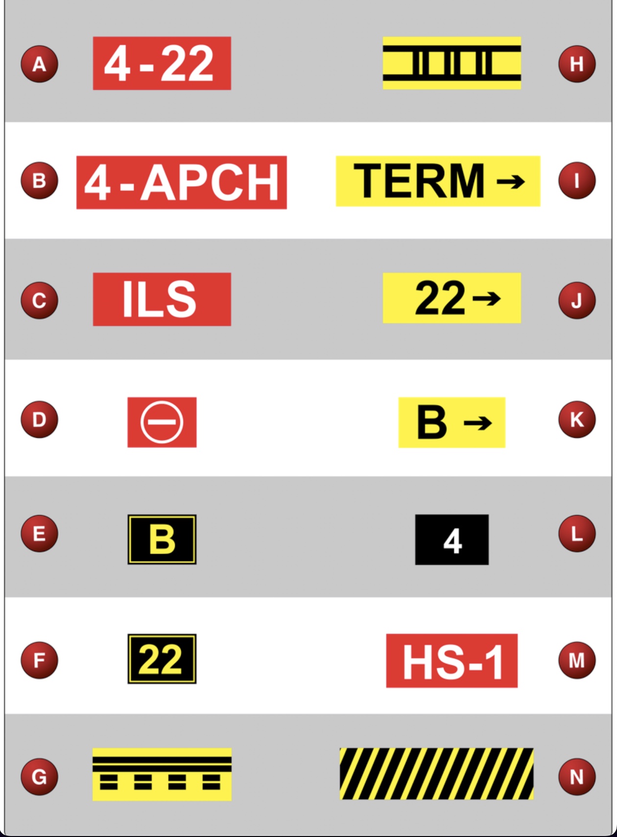
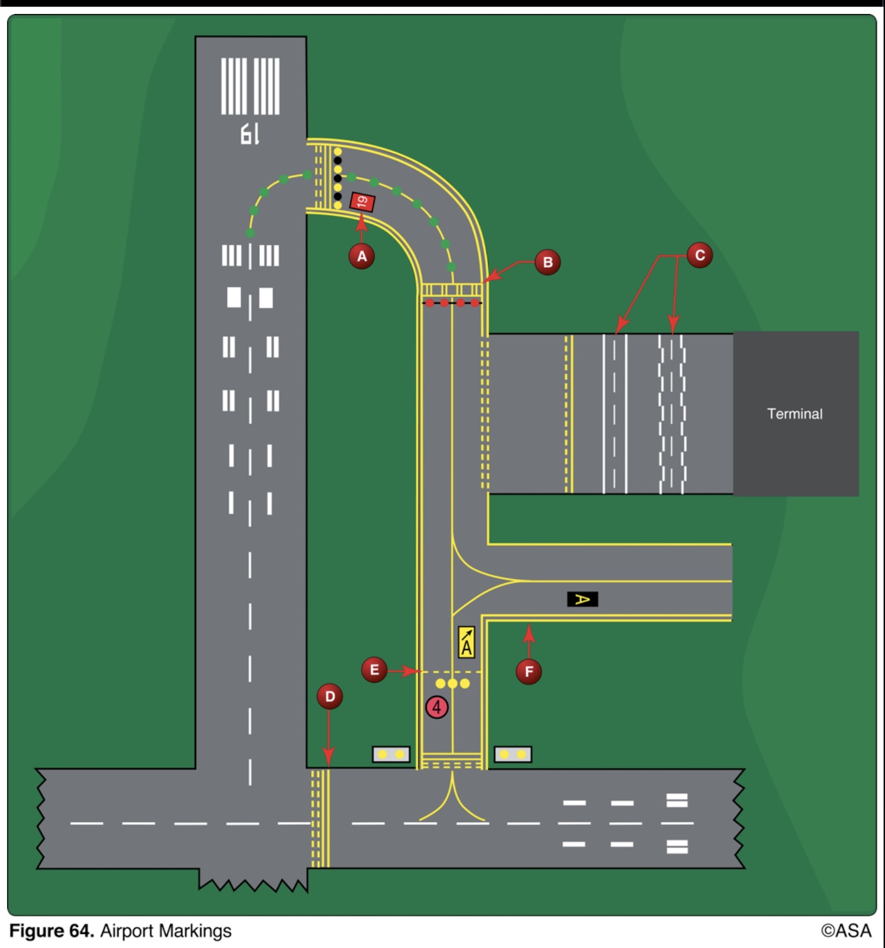
(Refer to Figure 65.) Which airport marking is a runway safety area/obstacle free zone boundary?
denotes intersecting runways
What is the purpose of the runway/runway hold position sign?
received prior authorization from the controlling agency
Flight through a restricted area should not be accomplished unless the pilot has
student pilots
Who should not participate in the Land and Hold Short Operations (LAHSO) program?
is cleared to land
A steady green light signal directed from the control tower to an aircraft in flight is a signal that the pilot
122.8 MHz
(Refer to Figure 22, area 2; and Figure 31.) At Coeur D'Alene, which frequency should be used as a Common Traffic Advisory Frequency (CTAF) to self-announce position and intentions?
when it will compromise safety
When should pilots decline a land and hold short (LAHSO) clearance?
South
An ATC radar facility issues the following advisory to a pilot flying on a heading of 090°:
'TRAFFIC THREE O'CLOCK, 2 MILES, WESTBOUND...'
Where should the pilot look for this traffic?
Ground control, on initial contact
From whom should a departing VFR aircraft request radar traffic information during ground operations?
Runway 22
(Refer to Figure 65.) Sign F confirms your position on

to the right Runway 18 and Runway 35; to the left on Runway 36
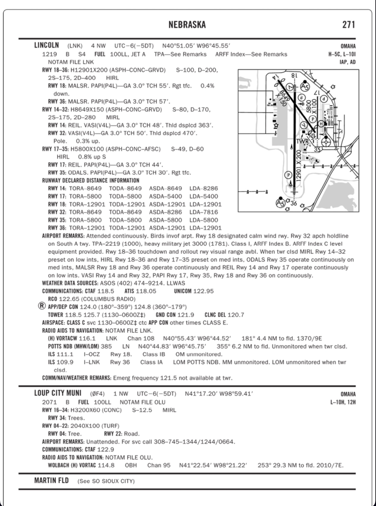
(Refer to Figure 52.) Traffic patterns in effect at Lincoln Municipal are

on a runway, about to clear
(Refer to Figure 65.) From the flight deck, marking G confirms the aircraft to be

C
(Refer to Figure 64.) Which marking indicates a vehicle lane?
‘ONE ZERO THOUSAND, FIVE HUNDRED.’
The correct method of stating 10,500 feet MSL to ATC is
122.8 MHz
(Refer to Figure 22, area 2; and Figure 31.) What is the correct UNICOM frequency to be used at Coeur D'Alene to request fuel?
three white lights and one red light
A slightly high glide slope indication from a precision approach path indicator is
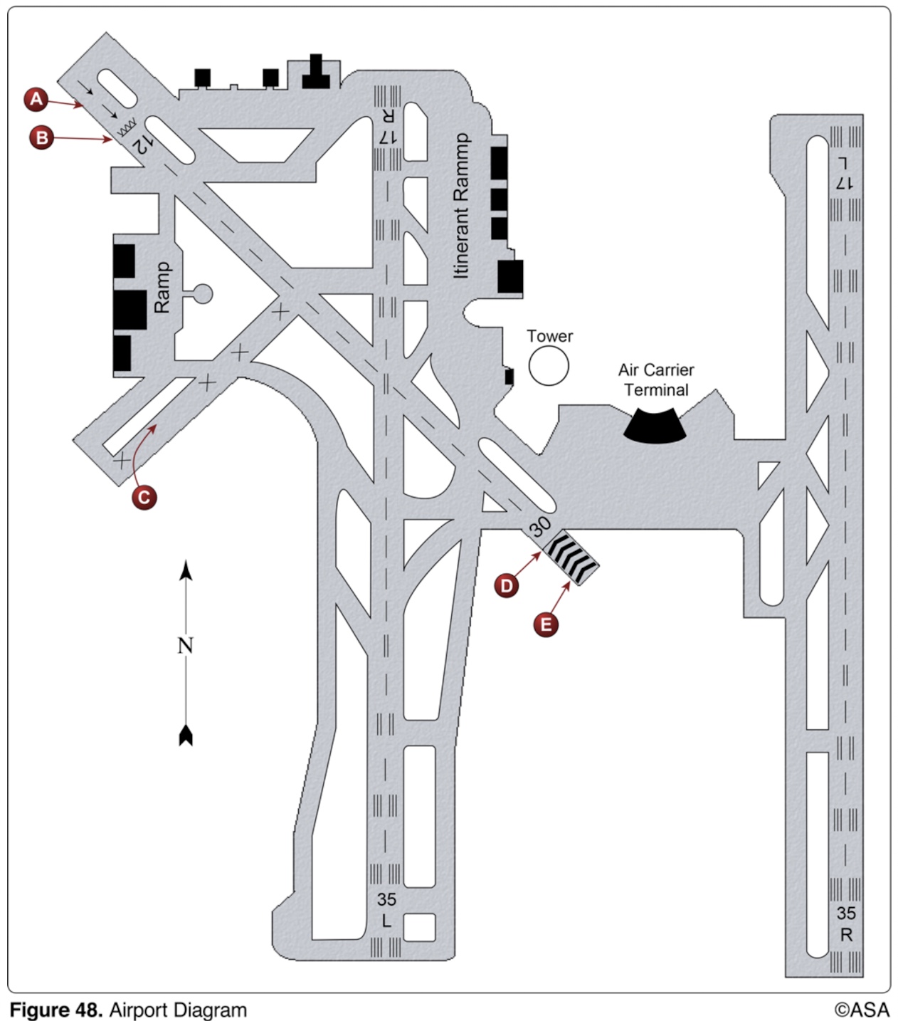
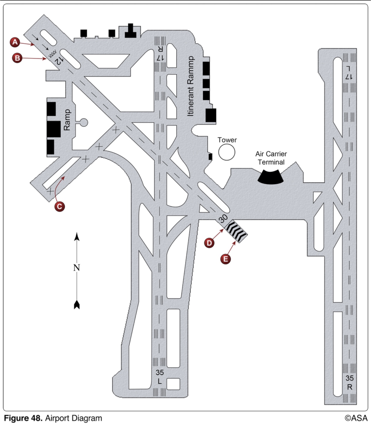
takeoffs may be started at position A on Runway 12, and the landing portion of this runway begins at position B
(Refer to Figure 48.) According to the airport diagram, which statement is true?
observe the traffic flow, enter the pattern, and look for a flight signal from the tower
If the aircraft's radio fails, what is the recommended procedure when landing at a controlled airport?
sequencing and separation from participating VFR aircraft
TRSA Service in the terminal radar program provides
two-way radio communications equipment, a 4096-code transponder, and an encoding altimeter
What minimum radio equipment is required for VFR operation within Class B airspace?
military training activities that necessitate acrobatic or abrupt flight maneuvers
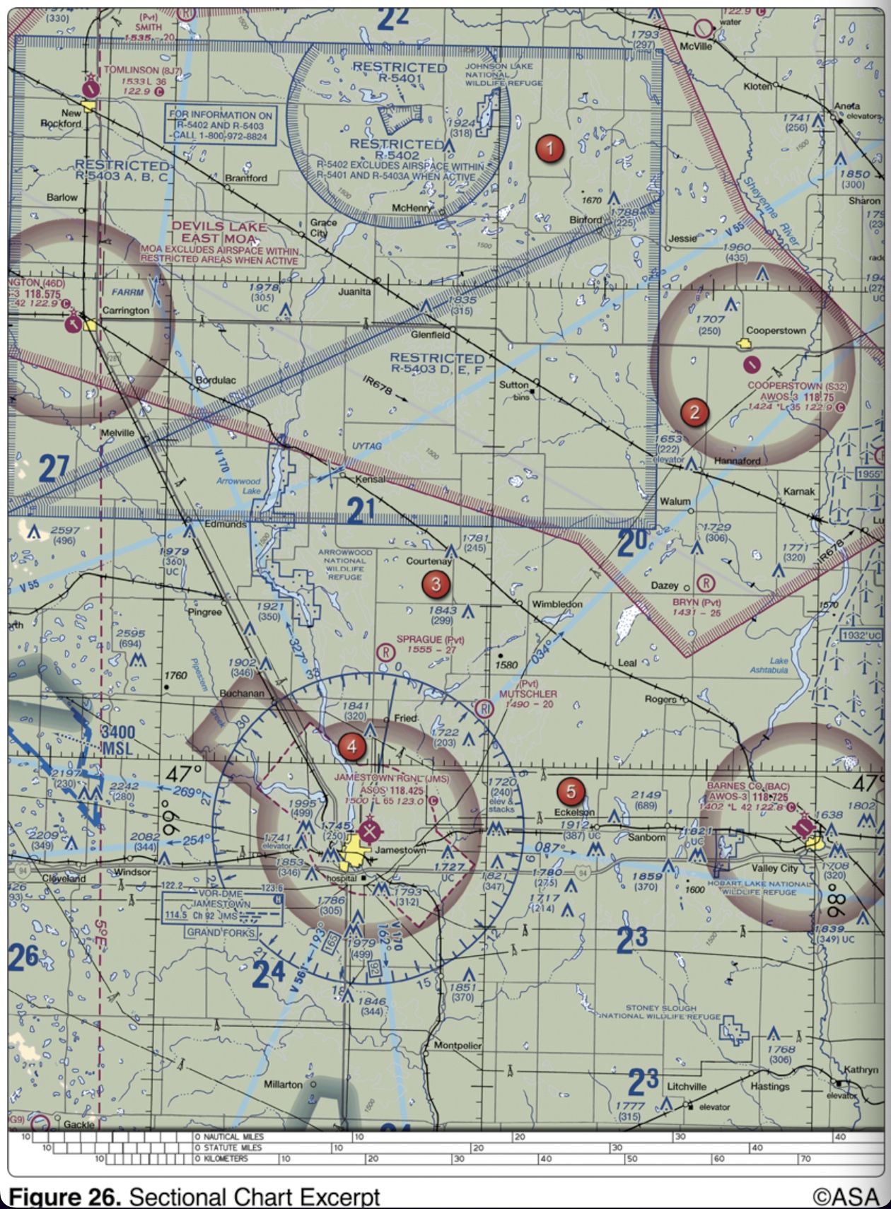
(Refer to Figure 26, area 2.) What hazards to aircraft may exist in areas such as Devils Lake East MOA?

blue omnidirectional lights
Airport taxiway edge lights are identified at night by
1,300 feet MSL
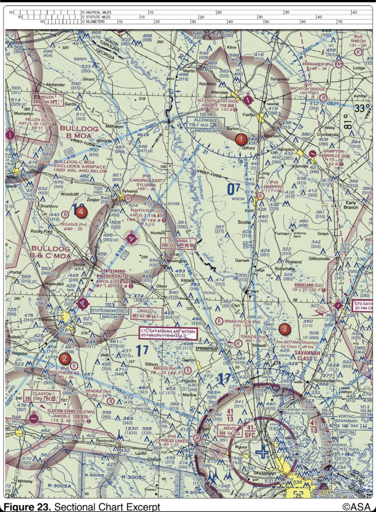
(Refer to Figure 23, area 3.) What is the floor of the Savannah Class C airspace at the shelf area (outer circle)?
maintain an altitude at or above the glide slope
When approaching to land on a runway served by a visual approach slope indicator (VASI), the pilot shall
5 (Five)
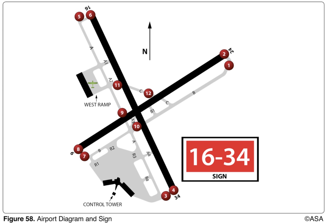
(Refer to Figure Commercial 58.) You have requested taxi instructions for takeoff using Runway 16. The controller issues the following taxi instructions: "N123, Taxi to Runway 16." Where are you required to stop in order to be in compliance with the controller's instructions
unusual, often invisible, hazards such as aerial gunnery or guided missiles
(Refer to Figure 20 area 4.) What hazards to aircraft may exist in restricted areas such as R-5302B?
On the Sectional Chart in the Special Use Airspace area
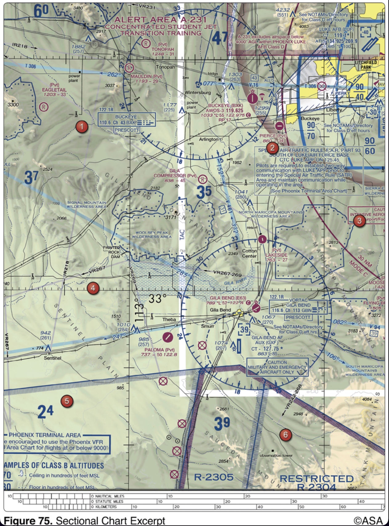
(Refer to Figure 75, west of Area 6.) During preflight planning, your course is plotted to fly through R-2305. Where would you find additional information regarding this airspace?
closed runway
(Refer to Figure 48.) Area C on the airport depicted is classified as a

all pilots
Responsibility for collision avoidance in an alert area rests with
Special Notices section of the Chart Supplements U.S.
Where is the Available Landing Distance (ALD) data published for an airport that utilizes Land and Hold Short Operations (LAHSO)?
Class G airspace from the surface to 700 feet AGL
(Refer to Figure 26, area 5.) The airspace overlying and within 5 miles of Barnes County Airport is

the instrument procedures for which the controlled airspace is established
The lateral dimensions of Class D airspace are based on
southeast of the airport
(Refer to Figure 50.) The traffic patterns indicated in the segmented circle have been arranged to avoid flights over an area to the

ground track
When an air traffic controller issues radar traffic information in relation to the 12-hour clock, the reference the controller uses is the aircraft`s
Runway 18 and except a crosswind from the right
(Refer to Figure 49.) If the wind is as shown by the landing direction indicator, the pilot should land on

Broadcast intentions when 10 miles out on the CTAF/MULTICOM frequency, 122.9 MHz
(Refer to Figure 26, area 2.) What is the recommended communication procedure when inbound to land at Cooperstown Airport?

when advised by the tower to do so
After landing at a tower-controlled airport, when should the pilot contact ground control?
right-quartering headwind
(Refer to Figure 50.) The segmented circle indicates that a landing on Runway 26 will be with a

identifies direction to take-off runways
What does the outbound destination sign identify?
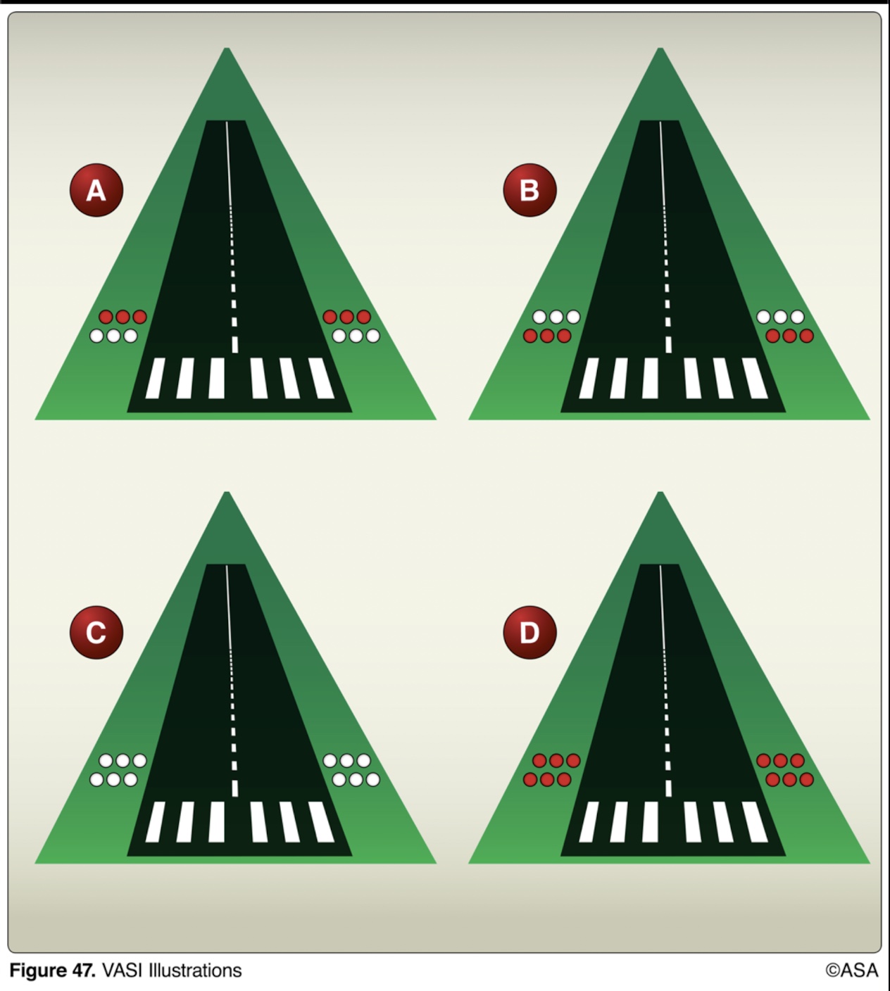
below the glide path
(Refer to Figure 47.) While on final approach to a runway equipped with a standard 2-bar VASI, the lights appear as shown by illustration D. This means that the aircraft is
4,000 feet MSL
(Refer to Figure 25, area 4.) The floor of Class B airspace overlying Hicks Airport (T67) north-northwest of Fort Worth Meacham Field is
090° and 270° magnetic
The numbers 9 and 27 on a runway indicate that the runway is oriented approximately
122.8 MHz
(Refer to Figure 26, area 5.) What is the CTAF/UNICOM frequency at Barnes County Airport?

123.0 MHz
(Refer to Figure 26, area 4.) The CTAF/UNICOM frequency at Jamestown Airport is

Two-way radio and Mode C transponder with altitude reporting equipment
(Refer to Figure 69.) What minimum equipment is required for a flight from Kleberg Co. Airport (area 7) to Corpus Christi Intl. Airport (area 3)?
Identifies a paved area where aircraft are prohibited from entering
What is the purpose of the no entry sign?
exercise extreme caution
An alternating red and green light signal directed from the control tower to an aircraft in flight is a signal to
the Chart Supplements U.S.
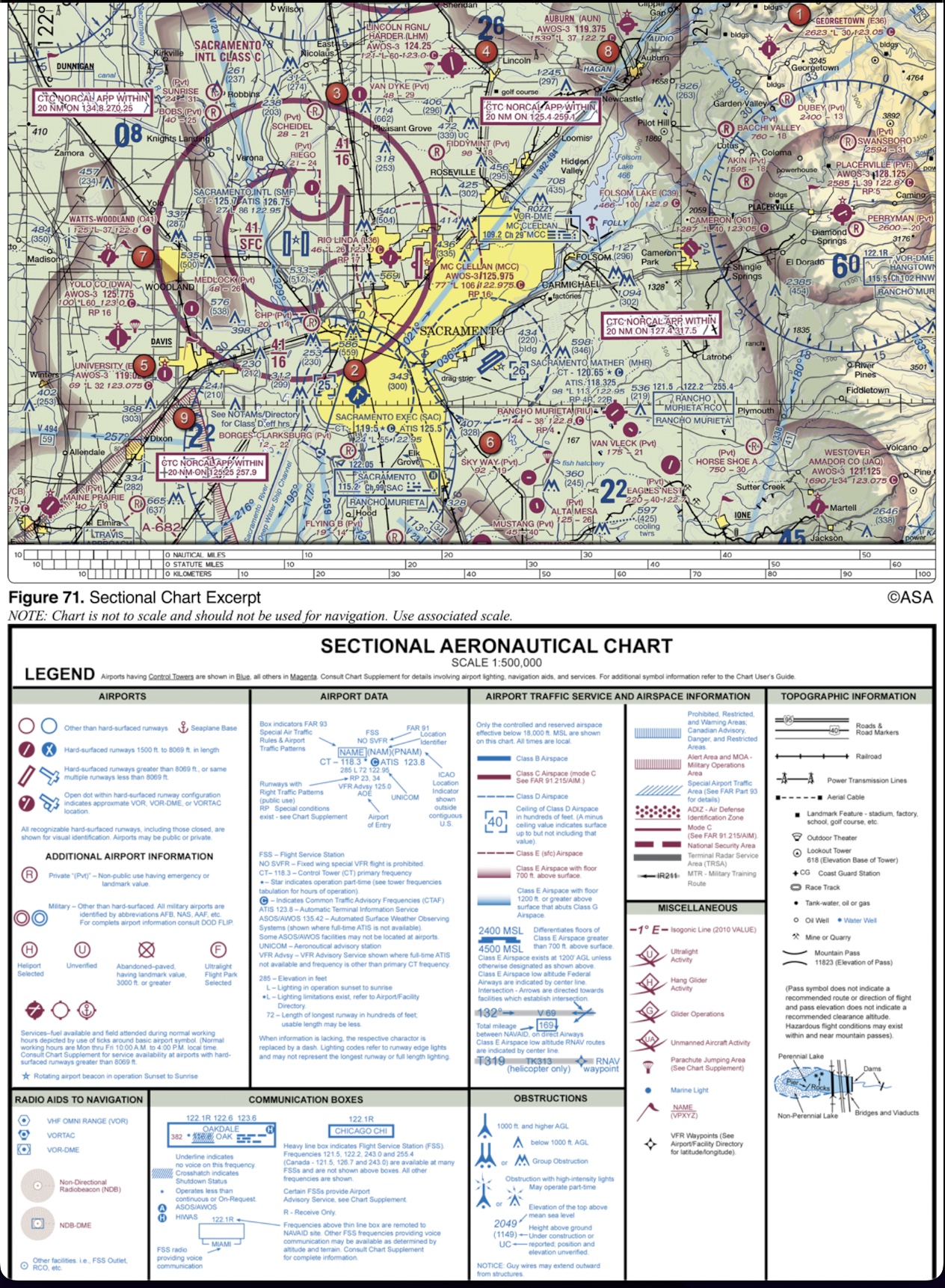
(Refer to Figure 71, area 4 and Legend 1.) For information about the parachute jumping operations at Lincoln Regional/ Harder (LHM) Airport, refer to
transmit intentions on 122.9 MHz when 10 miles out and give position reports in the traffic pattern
(Refer to Figure 20, area 3.) What is the recommended communications procedure for a landing at Currituck County Airport?

Northwest
An ATC radar facility issues the following advisory to a pilot flying on a heading of 360°:
'TRAFFIC TEN O'CLOCK, 2 MILES, SOUTHBOUND...'
Where should the pilot look for this traffic?
taxiing and takeoff
(Refer to Figure 48.) The portion of the runway identified by the letter A may be used for
indicates designation and direction of taxiway leading out of an intersection
When turning onto a taxiway from another taxiway, what is the purpose of the taxiway directional sign?
3,000 feet MSL
(Refer to Figure 25, area 2.) The floor of Class B airspace at Addison Airport is

contact approach control on the appropriate frequency
Which initial action should a pilot take prior to entering Class C airspace?
surface area Class E airspace
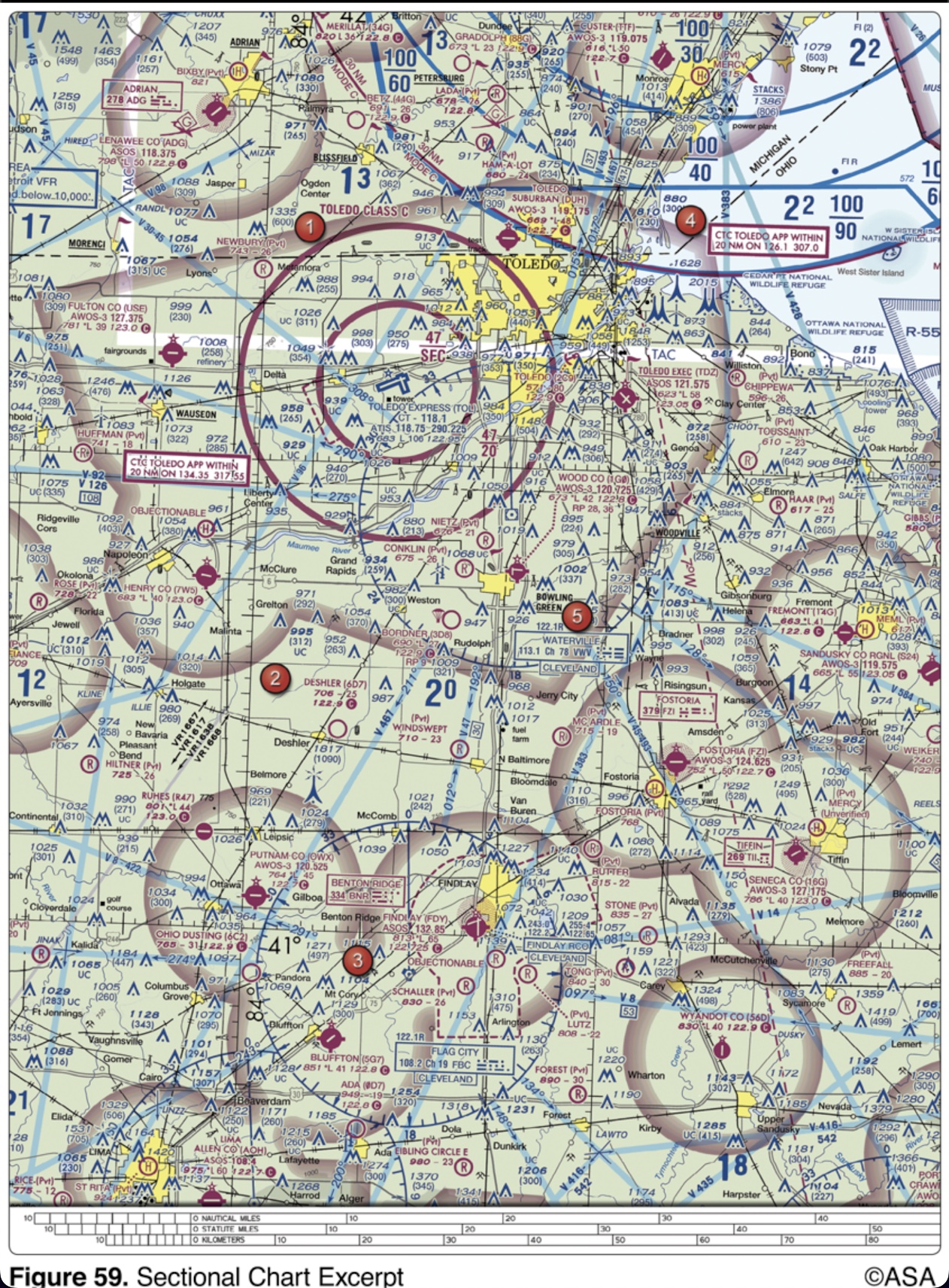
(Refer to Figure 59, area 3.) The airspace directly overlying the town of Findlay is
2,900 feet MSL
(Refer to figure 25, area 7.) The airspace overlying Collin Co RGL McKinney (TKI) is controlled from the surface to

1,000 feet and 3 miles
Normal VFR operations in Class D airspace with an operating control tower require the ceiling and visibility to be at least
‘FOUR THOUSAND FIVE HUNDRED.’
The correct method of stating 4,500 feet MSL to ATC is
3 statute miles
What is the minimum visibility for a pilot to receive a land and hold short (LAHSO) clearance?
the pilot must contact ATC as soon as practicable after takeoff
Under what condition may an aircraft operate from a satellite airport within Class C airspace?
ready for a Runway 22 intersection takeoff
(Refer to Figure 65.) A left turn at the intersection depicting sign A would place the aircraft
left aileron up, elevator neutral
(Refer to Figure 9, area A.) How should the flight controls be held while taxiing a tricycle-gear equipped airplane into a left quartering headwind?

2,000 feet AGL
(Refer to Figure 26, area 3.) When flying over Arrowwood National Wildlife Refuge, a pilot should fly no lower than
with the controlling agency’s authorization
Under what condition, if any, may pilots fly through a restricted area?
exercise extreme caution and abandon the approach, realizing the airport is unsafe for landing
While on final approach for landing, an alternating green and red light followed by a flashing red light is received from the control tower. Under these circumstances, the pilot should
Dallas-Fort Worth International and Dallas Love Field
(Refer to Figure 25.) At which airports is fixed-wing Special VFR not authorized?

Lincoln Approach Control on 124.0 MHz
(Refer to Figure 52.) When approaching Lincoln Municipal from the west at noon for the purpose of landing, initial communications should be with
quartering tailwind
Which wind condition would be most critical when taxiing a nosewheel equipped high-wing airplane?